682
9 roads in Russia, breathtaking
Russian roads — like the enchanted Princess. At first glance, ugly, but a little bit of perseverance — and it turns out that there is a hidden beauty which you will not find anywhere else.
Travel the roads of Russia, which like a fairy tale!
Explore Ural
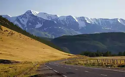
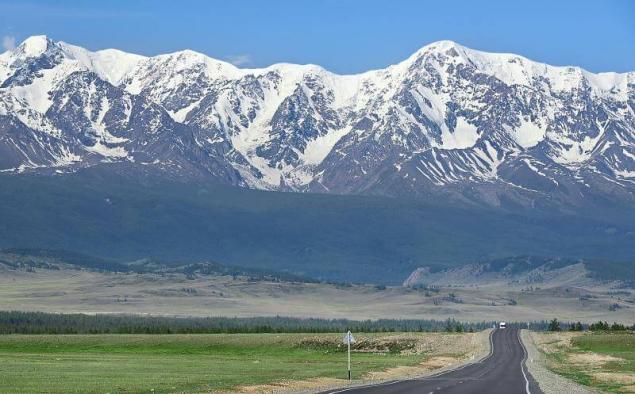
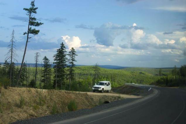
Ufa — Beloretsk — Abzakovo
Ural mountains visible from the Federal highway M-5. But it is rather a way to get from point a to point B than a real journey. More interesting to choose the road less, closer to nature, but not this loaded. For example, from Ufa to Abzakovo through Beloretsk. The drivers scare each other with potholes, switchbacks, and the famous 180-degree turn, which was called Teschin language. And everyone is sure he adds: "But the views are!".
It is a good idea to stop halfway in a mountain river Inzer in rest house or tent. To catch fish, sit around a campfire and stop at last nervous over every little thing.
After Beloretsk you can continue to ski resorts Abzakovo and Bannoe: snowy road similar to the large gallery in the ice Palace.
Another option is to roll to the side of a karst cave Shulgan-Tash, famous cave paintings of the Paleolithic era.
Another way to extend the pleasure to indulge in a detour to the village Tyuluk from which to climb the mountain Iremel.
Route length: 281 km
Start: Ufa
Finish: Abzakovo
The best time to travel: may-September and February-March
To overtake the caravan
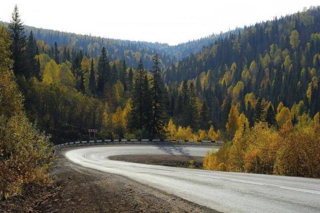
Chuysky trakt (M52 part of the track)
From Biysk to the South, the Altai mountains and the border with Mongolia, is blowin ' Chuyskiy trakt. The story of the main Altai of the road began in the days of the silk road when through the mountains carefully made their way the caravans with curiosities from distant countries.
The beauty of the Altai mountains then, thought little, were much more concerned with the Bohm — dangerous narrow places on the trail. The first wheeled road appeared here only in the beginning of the XX century, and the modern Chuysky tract — even later, in 1935.
Before leaving, examine the Museum of Chuiskiy trakt in Biysk — for inspiration. In the area of 510 km of the route taxied to the kennel and meet the Bialowieza bison. Climb to the highest point of the tchuisky highway, the Seminsky pass, and in my own way, reward yourself with hot pasties.
728 km look back: on the mountain Adyr-Kan-preserved ancient rock paintings, and nearby is a deer stone with the face of a warrior.
From the village of Aktash starts on the side of the road on the Teletskoe lake through spectacular and frightening mountain pass katu-Yaryk.
In short, the impressions from the trip Chuysk will bring no less than any of the Bavarian Alps.
The length of the route: from 571 km
Start: Biysk, Novosibirsk
Finish: the border with Mongolia
The best time to travel: June-September
Fall in love in Ladoga
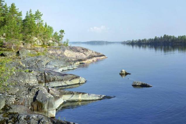
Olonets — Sortavala
In Karelia which road to take — all as a picture. Our favorite from Olonets to Sortavala on coast of Ladoga lake. Bays with sandy beaches on the East coast — our response to Turkey and Thailand. And the most entertaining plot winds along fjords and skerries of the Northern shore.
In the area of Rautalahti the road winds right along the edge of the Bay. The best thing to do is to get out of the car and climb the slope, as long as enough enthusiasm from the height of Ladoga even more wonderful.
In the season of navigation it is logical to continue the journey on the meteor from Sortavala to Valaam. In the winter, there goes the hovercraft.
Returning from a pilgrimage, go to the flooded marble quarries Ruskeala that turned into equipped mountain Park. Among the former mines, floating boats, flying to the trolls and dive with scuba — active entertainment especially pleasing after a long journey.
The length of the route: from 199 km
Start: Olonets and St. Petersburg
Finish: Sortavala
The best time to travel: may-October, January-March
Feel the romance of the mountains
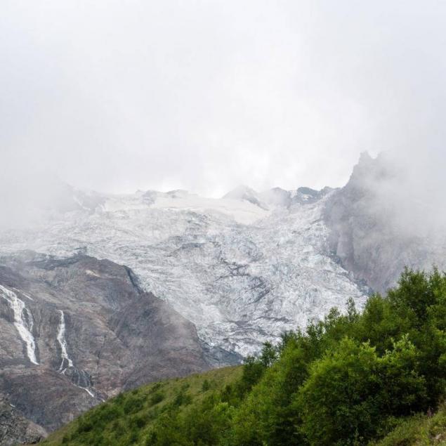
Alagir — Tseyskoe gorge
This white snow ski Academy — a Panacea for our troubles, We do not believe the words, but in camp "Hi" we All were happy partly.
So sang Yuri Vizbor, as thousands of climbers and outdoorsmen. Physics and poetry from the 60s until now sigh on the road that leads to Tseyskoe gorge. Today, the site of the camp is a mountain resort, where not only the hard men in helmets and ice axes, but simply lovers of the mountains. The road to "CEU" — in itself a tourist attraction. After leaving the city, it spreads along the river Ardon, and then suddenly jumps in Tseyskoe gorge. Behind the windshield — the enchanted pine forest, and even the sky as if getting closer. The last kilometer you will pass without asphalt and will be under clouds at a height of 2 thousand meters.
To a scary Sassomo the glacier can be reached by cable car and Tascosa leads to sustainable pathways.
Near the Top of the ceja behind a stone fence is a frame — Ossetian important sanctuary of rekom. Here worship wasgergi — the patron of men, warriors and travellers. Women Recomu near impossible, but a little further along the trail is the sanctuary, where there is no way men.
Route distance: 53 km
Start: Alagir or Vladikavkaz
Finish: Tsey
The best time to travel: all year round except November
Find the legendary path through the Caucasus
Cherkessk — Dombai, part of the former Military-Sukhumi highway
A long time ago through Klukhori pass to the Main Caucasian mountain range took place caravan trail. In the early twentieth century in its place built a road suitable for cars. She combined Cherkessk and Sukhumi and had all the chances to win the glory of the Georgian Military. It did not happen. In Soviet times, a cheerful tourists with guitars and huge backpacks were still able to quickly get of the mountain Dombai directly to the Black sea. Now through traffic for no cars, walking is also not allowed: after all the state border.
However, even in shortened form, from Cherkessk Dombay to the — this road is extremely picturesque. Steep turns, rococoa river, the thick forest on the slopes is a classic mountain road, which, despite the difficulties, I want to go and go. Alas, he Klukhori pass is now impossible under any circumstances.
But breath in Dombai, you can extend the familiarity with the Military-Sukhumi road to Trout lake. But if you previously issued the pass is the border, then a little further.
The length of the route: from 124 km
Start: Cherkessk, Stavropol or Mineral Water
Finish: Dombay
The best time to travel: all year round except November
To get to the Pacific ocean
Lidoga — Vanino, Khabarovsk Krai
Some roads are especially good when not up to the end built. Go hard — can't argue with that. But it will be tete-a-tete with the wildlife and feel almost a pioneer. Route from Lidoga to the port of Vanino on the sea of Japan began in the late 90s, connecting old logging roads, and officially has not yet completed. Something which is new asphalt, but many of the old, with potholes and pits, part of the route is unpaved. The journey is to dare if only because of the extraordinarily beautiful ridge of the Sikhote-Alin, which have to cross.
The first part of the journey — from Khabarovsk to Lidoga — driving on normal roads. Then she starts to zigzag through the hills and rises higher, revealing great views from the passes. Litovoi between Vanino and no villages and gas stations, the phone does not work, only one café, so prepare for a 6-hour road thoroughly. But when they finally descend to the Pacific ocean, is a feeling that it was a dream and not real road to the far East of Russia.
The length of the route: from 323 km
Start: Lidoga or Khabarovsk
Finish: Vanino
The best time to visit: may-June and September-October
Relax on the water
Tunka tract
Once on the lake, at least one eye look at the Tunka tract, reaching from the lake to the Mongolian border. Everything here is good: and the clear waters of the Irkut river, and villages of unpainted wooden houses and idyllic meadows, on which jingling bells, wandering cows, and the mountains around Paradise valley Tunkinskaya. To all this beauty keeps a great and almost empty road — a rare combination for our country.
The main attraction of Tunka valley — Arshan resort, where people come to receive medical treatment with mineral waters, and at the same time to wander along the mountain paths and to hand-feed chipmunks.
In the village of Kyren look at the Tushita Buddhist temple, the oldest in Buryatia.
In the village of khoyto-Gol will show you what for centuries was the life of the Buryat people. To heighten the entourage of the local historical Museum located in a wooden Yurt vosmitonny.
And pass the border you can drive to the foot of the beauties Munch-Sardyk — the highest peak of Sayan mountains.
Route length: 218 km from
Start: Kultuk or Irkutsk
Finish: the border with Mongolia
The best time to travel: all year round, except rainy seasons
Test yourself Kolyma
The Kolyma highway
To the highway "Kolyma" no one can remain indifferent. Especially if the day before to re-read "the Kolyma tales" Shalamov. Monument to the dead and the remains of the barracks among the austere landscapes do not give to forget that this road was built on the bones. Despite a terrible past, the Kolyma highway not repel, but, on the contrary, it attracts with its nastasescu and harsh beauty.
Bite into the permafrost, and picks Kyle started from Magadan. There is now a plot is an asphalt road is microscopic when compared with the countless miles of dusty primer. In autumn and spring in a straight line will not pass because not enough bridges. In the summer of the wheels rises in thick black dust. In the winter the road is covered with ice, and behind a Board — a terrible cold. Refills little cafes — also a signal only occasionally. And still come here: and in their cars, and hitchhiking. And then excitedly tell their friends that more impressive place it is difficult to find.
Route length: 2 032 km
Start: Yakutsk
Finish: Magadan
The best time to travel: mid June — September
Drive up to the volcano on the Kamchatka Peninsula
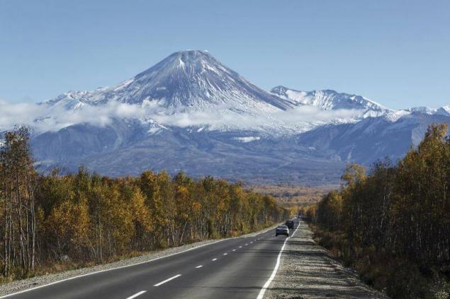
Petropavlovsk-Kamchatsky — Ust-Kamchatsk
Once on land, you are unlikely to pass the "road of life" connecting Petropavlovsk-Kamchatsky and Ust-Kamchatsk. As the flying carpet, she delivers another world — one ruled by majestic nature. Moreover, the rules literally: washed away part of the road is closed and it is unknown by how much. But if you're lucky with the weather, will look around big eyes: and volcanoes, which at first seem a Mirage, and a dense forest, and lakes, reflecting the hills.
It is better to go slowly, indulging the body and spirit in numerous hot springs. Photographers, keep at hand a telephoto lens: on the road there is the chance to see a hare, Fox, moose and even bear.
To stay in a familiar format suitable Esso — "Kamchatka Switzerland" and a picturesque lake Ikar.
A Mecca for lovers of active rest — volcanoes, the entrance to which change to "crane".
Also fun: 10 great routes for traveling by bike
Mysterious Kamchatka
However, anyone who decides to give up on Kamchatka, knows the iron rule: prohodila machine — the better.
Route length: 740 km
Start: Petropavlovsk-Kamchatsky
Finish: Ust ' -Kamchatsk
The best time to travel: the second half of July — first half of September. published
P. S. And remember, only by changing their consumption — together we change the world! ©
Source: www.skyscanner.ru/news/samye-krasivye-dorogi-rossii
Travel the roads of Russia, which like a fairy tale!
Explore Ural

Ufa — Beloretsk — Abzakovo
Ural mountains visible from the Federal highway M-5. But it is rather a way to get from point a to point B than a real journey. More interesting to choose the road less, closer to nature, but not this loaded. For example, from Ufa to Abzakovo through Beloretsk. The drivers scare each other with potholes, switchbacks, and the famous 180-degree turn, which was called Teschin language. And everyone is sure he adds: "But the views are!".
It is a good idea to stop halfway in a mountain river Inzer in rest house or tent. To catch fish, sit around a campfire and stop at last nervous over every little thing.
After Beloretsk you can continue to ski resorts Abzakovo and Bannoe: snowy road similar to the large gallery in the ice Palace.
Another option is to roll to the side of a karst cave Shulgan-Tash, famous cave paintings of the Paleolithic era.
Another way to extend the pleasure to indulge in a detour to the village Tyuluk from which to climb the mountain Iremel.
Route length: 281 km
Start: Ufa
Finish: Abzakovo
The best time to travel: may-September and February-March
To overtake the caravan

Chuysky trakt (M52 part of the track)
From Biysk to the South, the Altai mountains and the border with Mongolia, is blowin ' Chuyskiy trakt. The story of the main Altai of the road began in the days of the silk road when through the mountains carefully made their way the caravans with curiosities from distant countries.
The beauty of the Altai mountains then, thought little, were much more concerned with the Bohm — dangerous narrow places on the trail. The first wheeled road appeared here only in the beginning of the XX century, and the modern Chuysky tract — even later, in 1935.
Before leaving, examine the Museum of Chuiskiy trakt in Biysk — for inspiration. In the area of 510 km of the route taxied to the kennel and meet the Bialowieza bison. Climb to the highest point of the tchuisky highway, the Seminsky pass, and in my own way, reward yourself with hot pasties.
728 km look back: on the mountain Adyr-Kan-preserved ancient rock paintings, and nearby is a deer stone with the face of a warrior.
From the village of Aktash starts on the side of the road on the Teletskoe lake through spectacular and frightening mountain pass katu-Yaryk.
In short, the impressions from the trip Chuysk will bring no less than any of the Bavarian Alps.
The length of the route: from 571 km
Start: Biysk, Novosibirsk
Finish: the border with Mongolia
The best time to travel: June-September
Fall in love in Ladoga

Olonets — Sortavala
In Karelia which road to take — all as a picture. Our favorite from Olonets to Sortavala on coast of Ladoga lake. Bays with sandy beaches on the East coast — our response to Turkey and Thailand. And the most entertaining plot winds along fjords and skerries of the Northern shore.
In the area of Rautalahti the road winds right along the edge of the Bay. The best thing to do is to get out of the car and climb the slope, as long as enough enthusiasm from the height of Ladoga even more wonderful.
In the season of navigation it is logical to continue the journey on the meteor from Sortavala to Valaam. In the winter, there goes the hovercraft.
Returning from a pilgrimage, go to the flooded marble quarries Ruskeala that turned into equipped mountain Park. Among the former mines, floating boats, flying to the trolls and dive with scuba — active entertainment especially pleasing after a long journey.
The length of the route: from 199 km
Start: Olonets and St. Petersburg
Finish: Sortavala
The best time to travel: may-October, January-March
Feel the romance of the mountains

Alagir — Tseyskoe gorge
This white snow ski Academy — a Panacea for our troubles, We do not believe the words, but in camp "Hi" we All were happy partly.
So sang Yuri Vizbor, as thousands of climbers and outdoorsmen. Physics and poetry from the 60s until now sigh on the road that leads to Tseyskoe gorge. Today, the site of the camp is a mountain resort, where not only the hard men in helmets and ice axes, but simply lovers of the mountains. The road to "CEU" — in itself a tourist attraction. After leaving the city, it spreads along the river Ardon, and then suddenly jumps in Tseyskoe gorge. Behind the windshield — the enchanted pine forest, and even the sky as if getting closer. The last kilometer you will pass without asphalt and will be under clouds at a height of 2 thousand meters.
To a scary Sassomo the glacier can be reached by cable car and Tascosa leads to sustainable pathways.
Near the Top of the ceja behind a stone fence is a frame — Ossetian important sanctuary of rekom. Here worship wasgergi — the patron of men, warriors and travellers. Women Recomu near impossible, but a little further along the trail is the sanctuary, where there is no way men.
Route distance: 53 km
Start: Alagir or Vladikavkaz
Finish: Tsey
The best time to travel: all year round except November
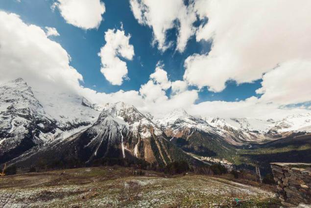
Find the legendary path through the Caucasus

Cherkessk — Dombai, part of the former Military-Sukhumi highway
A long time ago through Klukhori pass to the Main Caucasian mountain range took place caravan trail. In the early twentieth century in its place built a road suitable for cars. She combined Cherkessk and Sukhumi and had all the chances to win the glory of the Georgian Military. It did not happen. In Soviet times, a cheerful tourists with guitars and huge backpacks were still able to quickly get of the mountain Dombai directly to the Black sea. Now through traffic for no cars, walking is also not allowed: after all the state border.
However, even in shortened form, from Cherkessk Dombay to the — this road is extremely picturesque. Steep turns, rococoa river, the thick forest on the slopes is a classic mountain road, which, despite the difficulties, I want to go and go. Alas, he Klukhori pass is now impossible under any circumstances.
But breath in Dombai, you can extend the familiarity with the Military-Sukhumi road to Trout lake. But if you previously issued the pass is the border, then a little further.
The length of the route: from 124 km
Start: Cherkessk, Stavropol or Mineral Water
Finish: Dombay
The best time to travel: all year round except November
To get to the Pacific ocean

Lidoga — Vanino, Khabarovsk Krai
Some roads are especially good when not up to the end built. Go hard — can't argue with that. But it will be tete-a-tete with the wildlife and feel almost a pioneer. Route from Lidoga to the port of Vanino on the sea of Japan began in the late 90s, connecting old logging roads, and officially has not yet completed. Something which is new asphalt, but many of the old, with potholes and pits, part of the route is unpaved. The journey is to dare if only because of the extraordinarily beautiful ridge of the Sikhote-Alin, which have to cross.
The first part of the journey — from Khabarovsk to Lidoga — driving on normal roads. Then she starts to zigzag through the hills and rises higher, revealing great views from the passes. Litovoi between Vanino and no villages and gas stations, the phone does not work, only one café, so prepare for a 6-hour road thoroughly. But when they finally descend to the Pacific ocean, is a feeling that it was a dream and not real road to the far East of Russia.
The length of the route: from 323 km
Start: Lidoga or Khabarovsk
Finish: Vanino
The best time to visit: may-June and September-October
Relax on the water

Tunka tract
Once on the lake, at least one eye look at the Tunka tract, reaching from the lake to the Mongolian border. Everything here is good: and the clear waters of the Irkut river, and villages of unpainted wooden houses and idyllic meadows, on which jingling bells, wandering cows, and the mountains around Paradise valley Tunkinskaya. To all this beauty keeps a great and almost empty road — a rare combination for our country.
The main attraction of Tunka valley — Arshan resort, where people come to receive medical treatment with mineral waters, and at the same time to wander along the mountain paths and to hand-feed chipmunks.
In the village of Kyren look at the Tushita Buddhist temple, the oldest in Buryatia.
In the village of khoyto-Gol will show you what for centuries was the life of the Buryat people. To heighten the entourage of the local historical Museum located in a wooden Yurt vosmitonny.
And pass the border you can drive to the foot of the beauties Munch-Sardyk — the highest peak of Sayan mountains.
Route length: 218 km from
Start: Kultuk or Irkutsk
Finish: the border with Mongolia
The best time to travel: all year round, except rainy seasons
Test yourself Kolyma

The Kolyma highway
To the highway "Kolyma" no one can remain indifferent. Especially if the day before to re-read "the Kolyma tales" Shalamov. Monument to the dead and the remains of the barracks among the austere landscapes do not give to forget that this road was built on the bones. Despite a terrible past, the Kolyma highway not repel, but, on the contrary, it attracts with its nastasescu and harsh beauty.
Bite into the permafrost, and picks Kyle started from Magadan. There is now a plot is an asphalt road is microscopic when compared with the countless miles of dusty primer. In autumn and spring in a straight line will not pass because not enough bridges. In the summer of the wheels rises in thick black dust. In the winter the road is covered with ice, and behind a Board — a terrible cold. Refills little cafes — also a signal only occasionally. And still come here: and in their cars, and hitchhiking. And then excitedly tell their friends that more impressive place it is difficult to find.
Route length: 2 032 km
Start: Yakutsk
Finish: Magadan
The best time to travel: mid June — September
Drive up to the volcano on the Kamchatka Peninsula

Petropavlovsk-Kamchatsky — Ust-Kamchatsk
Once on land, you are unlikely to pass the "road of life" connecting Petropavlovsk-Kamchatsky and Ust-Kamchatsk. As the flying carpet, she delivers another world — one ruled by majestic nature. Moreover, the rules literally: washed away part of the road is closed and it is unknown by how much. But if you're lucky with the weather, will look around big eyes: and volcanoes, which at first seem a Mirage, and a dense forest, and lakes, reflecting the hills.
It is better to go slowly, indulging the body and spirit in numerous hot springs. Photographers, keep at hand a telephoto lens: on the road there is the chance to see a hare, Fox, moose and even bear.
To stay in a familiar format suitable Esso — "Kamchatka Switzerland" and a picturesque lake Ikar.
A Mecca for lovers of active rest — volcanoes, the entrance to which change to "crane".
Also fun: 10 great routes for traveling by bike
Mysterious Kamchatka
However, anyone who decides to give up on Kamchatka, knows the iron rule: prohodila machine — the better.
Route length: 740 km
Start: Petropavlovsk-Kamchatsky
Finish: Ust ' -Kamchatsk
The best time to travel: the second half of July — first half of September. published
P. S. And remember, only by changing their consumption — together we change the world! ©
Source: www.skyscanner.ru/news/samye-krasivye-dorogi-rossii