2530
The ends of Russia
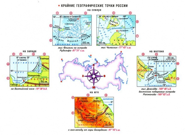
Russia is located in the north of Eurasia, occupies about a third of its territory (31, 5%). Extreme northern and eastern point of the mainland are both extremes of Russia. The country is in two parts of the world and occupies the eastern sector of Europe and northern Asia. Russia is washed by the seas of three oceans: the Atlantic, Arctic and Pacific.
The border between Europe and Asia within the Russian held the Ural mountains and the Kuma-Manych Depression. For Europe is only slightly more than 1/5 of the area of the country (about 22%). It is often under the European territory of Russia meant the whole territory lying west of the Urals (23% area). In any case, the share of the Asian part of Russia accounts for over 3/4 of the country. After Wrangel Island and Chukotka passes 180th meridian, hence the eastern edge of Russia lies in the Western Hemisphere. The geographical center of Russia located in the Krasnoyarsk Territory, Evenkia Autonomous District on Lake Vivi. In Tuva, near Kyzyl, it is the center of Asia.
The Russian Federation is the largest in size of territory country in the world, the area of the country is 17 million 75 thousand. 400 km2 (one-eighth of the area of the world). Area of Russia in 1, 7 times the size of Europe and in 1, 8 times the area of the US, 2 times the size of China's and 29 times the area of the largest European country - Ukraine.

The extreme northern point
The extreme northern point of mainland Russia is far above the Arctic Circle on the Chelyuskin Cape (77 ° 43 'N).
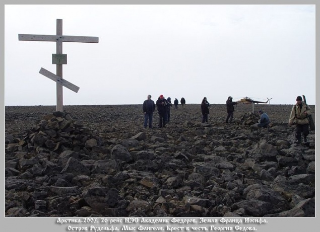
Cape Chelyuskin, which is the northernmost point of the Taimyr Peninsula and the mainland of Eurasia, man first reached in 1742. Then the team headed by Semyon Chelyuskin called the East Cape North. It was part of the Great Northern Expedition, which was approved by the Admiralty Board, believes that it is necessary to investigate in detail the north of Russia from the Pechora to Chukotka and to make the description of the places. In honor of Semyon Chelyuskin, polar explorer and researcher of northern Russia, the cape was named already in 1842, when the centenary of his expedition.
Track Log Chelyuskin, in which he shares his impressions of his journey by dog sled, difficult path it has carried out with his friends, and their arrival at the Cape, still kept in St. Petersburg, in the archives of the Navy.
The northernmost point of the Taimyr Peninsula is different harsh climate. The winter here is year-round, snow hardly melts and the temperature in July and August usually does not exceed ± 1C °.
The second person, who visited on the cape, became a geologist and geographer from Sweden Nils Nordenskiöld. The third was a Norwegian Fridtjof Nansen, which is September 9, 1893 sailed past Cape Chelyuskin in a strong snow storm on the ship "Fram».
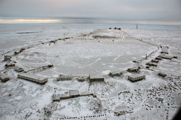
The station is called radio-meteorological center where winter from 8 to 10 people. It built a number of residential buildings and research pavilions. Some of the buildings abandoned and not maintained. It is also the most northern airport and continental Eurasia "Cape Chelyuskin", which served Khatanga associate airline. From the airport there was only a helipad, served the military.
In 1932 on the Cape was undeveloped polar station, which was later added to the observatory. Now the station is transferred to the status of the weather. She constantly winter about 10 people. Communication with the mainland and civilization provides airport "Cape Chelyuskin" with a helipad.
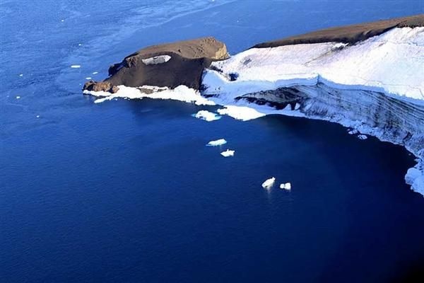
And one more point of the island: Cape Fligely on Rudolf Island in the archipelago of Franz Josef Land is located further north - 81 ° 49 'N, the distance from Cape Fligely to the North Pole is only 900 km.
Rudolf Island - the northernmost of the islands of Franz Josef Land. Cape Fligely Island - the northernmost point of land, owned by the Russian Federation, while the northernmost point of Europe. The island administratively belongs to the Arkhangelsk region. The area of 297 km² .. almost completely covered by a glacier.
The island, like the entire archipelago of Franz Josef Land, opened in 1873 by the Austro-Hungarian expedition researcher Yu Payer, was named Rudolf, Crown Prince of Austria. In 1936, the island base was established the first Soviet air expedition to the North Pole. From there, in May 1937, four heavy four-engine ANT-6 papanintsev delivered on top of the world.
Weather station on Rudolf Island was opened in August 1932 in the framework of the Second International Polar Year. In the first winter were 4 persons headed by N.F.Balabinym. A year later mothballed station, and again work continued in the summer of 1936. Initially, the station was equipped as an air base for an expedition in 1937 to the North Pole. Near the station and on the ice dome islands were equipped airfields. In the period from April 1942 until 1947 - it was again closed down. The last period of the 1947-1995 years.
The extreme southern point
In the first version of the extreme southernmost point is located southwest of Mount Bazarduzu in the eastern part of the Main, or Watershed, the ridge of the Greater Caucasus, on the border of Dagestan and Azerbaijan. Latitude point of 41 ° 11 'N The distance between the extreme northern and southern points above 40 ° meridian, and northernmost point is removed from the South at 36 to 5 °. It is just over 4 thousand. Km.
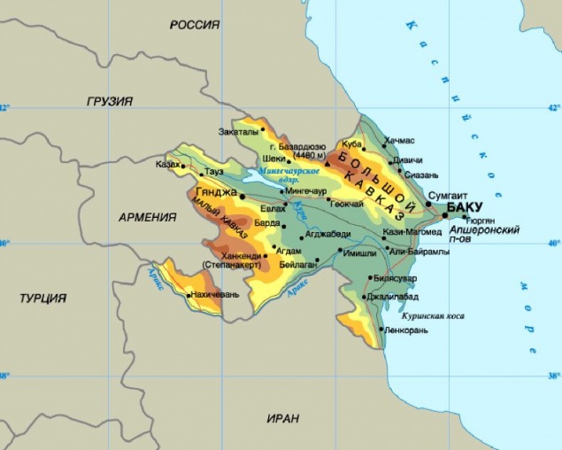
All directories specified - Bazarduzu (4466 m *) - the highest mountain peaks of the Republic of Dagestan and neighboring Azerbaijan. 41 ° 13'16 "with. w. 47 ° 51'29 "in. d.
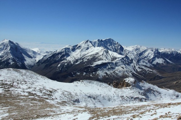
However, there is another version: Far southern bend of the border between Russia and Azerbaijan is located a few kilometers southwest of the peak Bazarduzu. For the southern part of Russia is closer to Mount Ragdan (41 ° 12 'N) A village Kurush the southernmost town ...
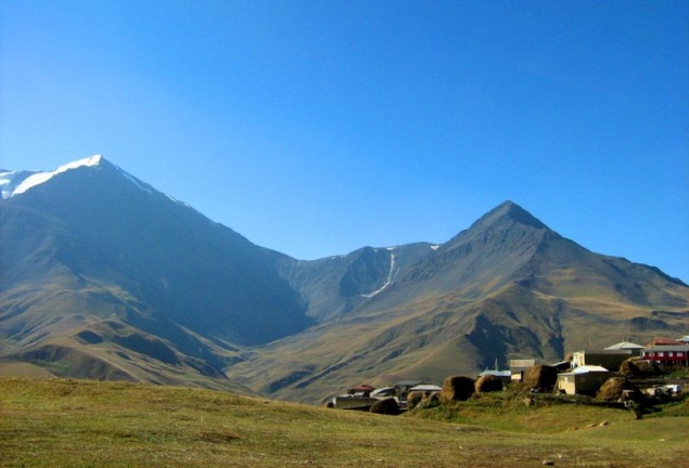
The top left - Bazarduzu right - Ragdan
Usuhchaya Valley is unique in the possession of the epithet "the best", "most", "most". It is the easternmost glacier of Dagestan - Tihitsar. And the southernmost glacier of Dagestan and Russia - Charyn also lies in the basin. Near the glacier towering mountain Charyn Ragdan - the southernmost point of the Russian Federation. One of the longest and high rock walls of the Caucasus is Erydag Western Wall - the pride of our climbers stenolaz. Finally, the highest peak of Dagestan - Bazarduzu (4466 m) and is adjacent to Valley Usuhchaya. It may be noted another natural phenomenon of the valley. From the crest of Erydag breaks down to a depth of 300 meters Charaur waterfall, the highest in Dagestan.
For the southern part of Russia is closer to Mount Ragdan (41 ° 12 'N), but it can be found only on large-scale maps.
This length of the territory from north to south in conjunction with pulse position is determined by the uneven flow of heat to the surface of the country and the formation within it three climatic zones (the Arctic, sub-Arctic and temperate), and ten natural areas (from deserts to the arctic deserts of the temperate zone). The main part of the territory of Russia is between 70 and 50 ° N About 20% of the territory lies above the Arctic Circle. The area of the northern regions is 10 million km2, in this respect can only serve analogue Canada.
The extreme western point
The extreme western point of Russia is located in the Kaliningrad region on the Baltic sandy spit of the Gulf of Gdansk in the Baltic Sea 19 ° 38 '30 & quot; East But due to the fact that the Kaliningrad region is separated from the rest of the area of Russian territory of other states and is an enclave, the westernmost point turned into a kind of "island" point.
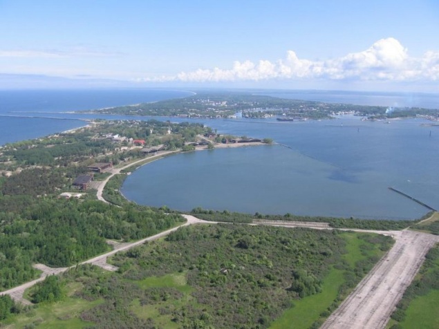
Also called the western point of the compact part of Russia, that is without taking into account the Kaliningrad region - in the Pskov region, just north of the junction of the borders of Estonia, Latvia and Russia (27 ° 17 'E).
Easternmost point
The extreme eastern point of Russia is on the mainland at Cape Dezhnev (169 ° 40 'W) - Ratmanova Island in the Bering Strait to the east is more - 169 ° 02' W
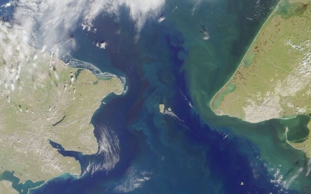
Cape Dezhnev, one of the most brutal places Chukotka Peninsula. Here the rocks are piled on one another, often fog and cold wind blowing constantly. From this point to the extreme western point of America - Cape Prince of Wales - 86 kilometers.
Despite the remoteness from civilization, in these places there are attractions. The lighthouse named Semyon Dezhnev and ancient cross set beside an abandoned whaling village of XVIII-XX centuries - Naukan (it was disbanded during the Soviet era). However, those who are taken in this region, go to look at the unique fauna: here are the numerous bird colonies, there are walrus and seals haul out in the spring, you can see the polar bears with cubs. Sometimes, very close to the shore and swim killer whales, gray whales.
Semyon Dezhnev in 1648 rounded the Chukotka Peninsula in the north and proved that from Europe to China and can be reached through the northern seas. He is 80 years ahead of Vitus Bering went through the strait that separates America from Eurasia, but about Russian pioneers in the Old World, then little known. Therefore, the glory went to Bering. However, in 1879, restoring justice, Swedish Arctic explorer Nils Nordenskiöld named the easternmost point of Eurasia - Cape Dezhnev, Russian explorer named. Until that time called Eastern Cape.
Getting there: The nearest settlement Whalen is 10 kilometers from Cape Dezhnev, and the nearest airport is located in Providence Bay, where planes fly from Anadyr.
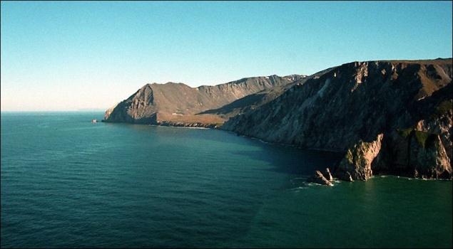
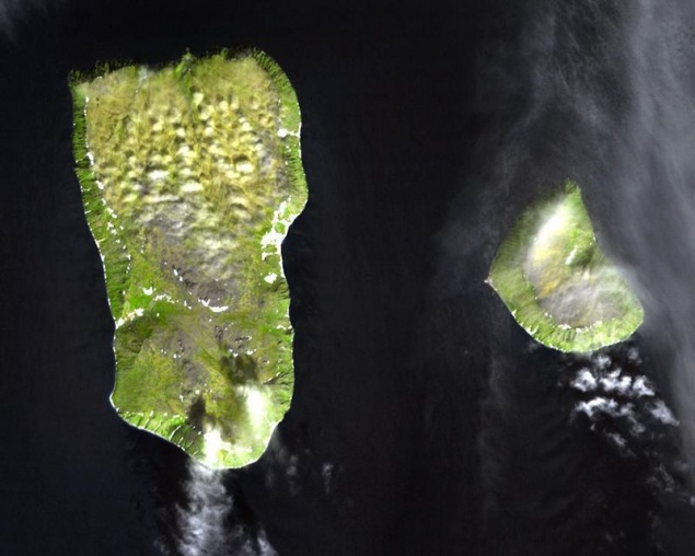
Island Ratmanovaimeet irregular shape (a length of about 9 km, width - 5 km) and an area of about 10 square meters. km; it is essentially a large rock with a flat top. Just 4 km 160 m Located Little Diomede Island (formerly Little Diomede), an area of about 5 square meters. km, which is owned by the USA. Immediately there is a rock Fairway. Name Diomede this archipelago gave Vitus Bering, who on the boat "St. Gabriel" came to the big island August 16, 1728 the day of St. Diomede. But even before this name Ratmanova island already had a name - Imaklik (translated from the Eskimo - "surrounded by water"), which gave him the Eskimos, who lived on it for more than two thousand years. By the way, Little Diomede Island (formerly Little Diomede) Ingalik called Eskimos, meaning "opposite."
The history of the island to give the name Ratmanova is. In 1816 the famous explorer Otto Kotzebue, exploring the Bering Strait, mistakenly counted in the archipelago Diomede not three (as applied to map more in 1732), and four islands. "Newly discovered" the island, he decided to give the name of his colleague - a naval officer Ratmanova Makara, which took part in the world expedition several years earlier. When an error is detected, we decided to leave the name Ratmanova on the map, and from the middle of the nineteenth century, Big Diomede changed its name.
Western (large) - Island Ratmanova
Island - like gable roof with extensive flatter northern slope. From south to north, as if bending the middle of it, flowing river with swampy shores and close to the raised edges begin scattering of bare rocks and bizarre outliers. South slope smaller but steeper. Buttes it numerous and steep banks above. Place the joint of both rays form a small mountain range, whose highest point is called - Roof Mount. The island occupies a key position on the border of Asia and North America and the two oceans - the Pacific and the Arctic. From it can be seen a huge area. In dozens of kilometers to the west, north and east is easy to follow movements of marine animals and the migration of birds.
On the island lived a bold sailors Eskimo inupik. Through them I was barter Asian and American Eskimos, they have been at the center of all the events of the Northern Bёringomorya and creating their own culture, perceived by many cultural traditions that have existed on both continents. In 1948, with the beginning of the Cold War between the Soviet Union and the United States have settled out inhabitants of the island to the mainland.
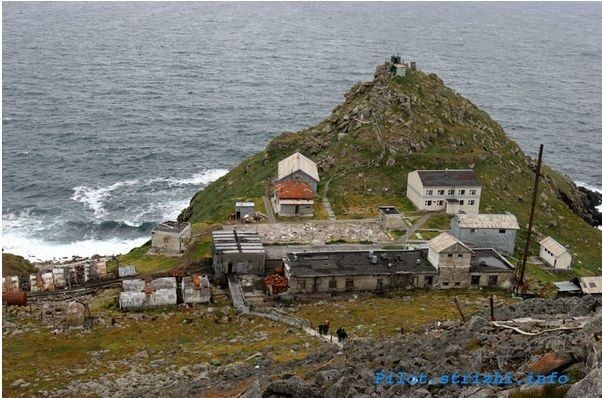
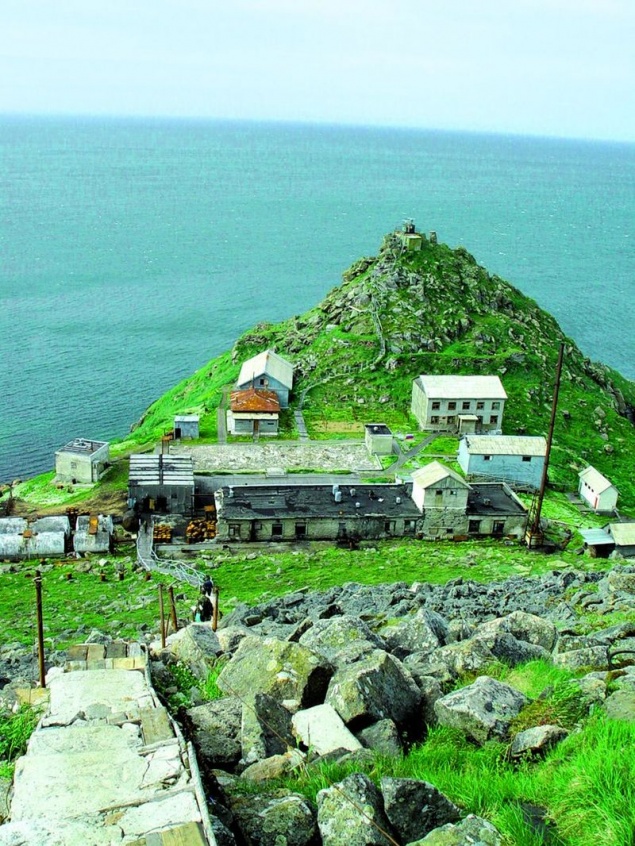
Now the island is Ratmanova Russian frontier. On the island there Kruzenshtern village with a population of 600 people. Between these islands runs the Russian-US border, as well as the international Date Line. To get to the island Ratmanova not just difficult, but daunting. And not just because it's actually the state border, but also the weather conditions - 300 days of the year the island is shrouded in a dense fog. The shortest path: from Anadyr helicopter through St. Lawrence. But it is only after receiving permission from SVRPU. But it's worth it!
The distance between the western and eastern border regions of Russia is 171 ° 20 ', or almost 10 thousand. Km. When the huge extent of the territory from west to east varying degrees of continental climate, which entails a change in the expression of the sectoral nature. Within the Russian Federation there are 10 time zones. The highest point is Mount Elbrus Russia (5642 m), located in the Karachay-Cherkess Republic on the border with the Kabardino-Balkar Republic. The lowest altitude is marked on the Caspian depression (- 28 m).
Source: masterok.livejournal.com
The border between Europe and Asia within the Russian held the Ural mountains and the Kuma-Manych Depression. For Europe is only slightly more than 1/5 of the area of the country (about 22%). It is often under the European territory of Russia meant the whole territory lying west of the Urals (23% area). In any case, the share of the Asian part of Russia accounts for over 3/4 of the country. After Wrangel Island and Chukotka passes 180th meridian, hence the eastern edge of Russia lies in the Western Hemisphere. The geographical center of Russia located in the Krasnoyarsk Territory, Evenkia Autonomous District on Lake Vivi. In Tuva, near Kyzyl, it is the center of Asia.
The Russian Federation is the largest in size of territory country in the world, the area of the country is 17 million 75 thousand. 400 km2 (one-eighth of the area of the world). Area of Russia in 1, 7 times the size of Europe and in 1, 8 times the area of the US, 2 times the size of China's and 29 times the area of the largest European country - Ukraine.


The extreme northern point
The extreme northern point of mainland Russia is far above the Arctic Circle on the Chelyuskin Cape (77 ° 43 'N).
Cape Chelyuskin, which is the northernmost point of the Taimyr Peninsula and the mainland of Eurasia, man first reached in 1742. Then the team headed by Semyon Chelyuskin called the East Cape North. It was part of the Great Northern Expedition, which was approved by the Admiralty Board, believes that it is necessary to investigate in detail the north of Russia from the Pechora to Chukotka and to make the description of the places. In honor of Semyon Chelyuskin, polar explorer and researcher of northern Russia, the cape was named already in 1842, when the centenary of his expedition.

Track Log Chelyuskin, in which he shares his impressions of his journey by dog sled, difficult path it has carried out with his friends, and their arrival at the Cape, still kept in St. Petersburg, in the archives of the Navy.
The northernmost point of the Taimyr Peninsula is different harsh climate. The winter here is year-round, snow hardly melts and the temperature in July and August usually does not exceed ± 1C °.
The second person, who visited on the cape, became a geologist and geographer from Sweden Nils Nordenskiöld. The third was a Norwegian Fridtjof Nansen, which is September 9, 1893 sailed past Cape Chelyuskin in a strong snow storm on the ship "Fram».

The station is called radio-meteorological center where winter from 8 to 10 people. It built a number of residential buildings and research pavilions. Some of the buildings abandoned and not maintained. It is also the most northern airport and continental Eurasia "Cape Chelyuskin", which served Khatanga associate airline. From the airport there was only a helipad, served the military.
In 1932 on the Cape was undeveloped polar station, which was later added to the observatory. Now the station is transferred to the status of the weather. She constantly winter about 10 people. Communication with the mainland and civilization provides airport "Cape Chelyuskin" with a helipad.

And one more point of the island: Cape Fligely on Rudolf Island in the archipelago of Franz Josef Land is located further north - 81 ° 49 'N, the distance from Cape Fligely to the North Pole is only 900 km.
Rudolf Island - the northernmost of the islands of Franz Josef Land. Cape Fligely Island - the northernmost point of land, owned by the Russian Federation, while the northernmost point of Europe. The island administratively belongs to the Arkhangelsk region. The area of 297 km² .. almost completely covered by a glacier.

The island, like the entire archipelago of Franz Josef Land, opened in 1873 by the Austro-Hungarian expedition researcher Yu Payer, was named Rudolf, Crown Prince of Austria. In 1936, the island base was established the first Soviet air expedition to the North Pole. From there, in May 1937, four heavy four-engine ANT-6 papanintsev delivered on top of the world.
Weather station on Rudolf Island was opened in August 1932 in the framework of the Second International Polar Year. In the first winter were 4 persons headed by N.F.Balabinym. A year later mothballed station, and again work continued in the summer of 1936. Initially, the station was equipped as an air base for an expedition in 1937 to the North Pole. Near the station and on the ice dome islands were equipped airfields. In the period from April 1942 until 1947 - it was again closed down. The last period of the 1947-1995 years.
The extreme southern point
In the first version of the extreme southernmost point is located southwest of Mount Bazarduzu in the eastern part of the Main, or Watershed, the ridge of the Greater Caucasus, on the border of Dagestan and Azerbaijan. Latitude point of 41 ° 11 'N The distance between the extreme northern and southern points above 40 ° meridian, and northernmost point is removed from the South at 36 to 5 °. It is just over 4 thousand. Km.

All directories specified - Bazarduzu (4466 m *) - the highest mountain peaks of the Republic of Dagestan and neighboring Azerbaijan. 41 ° 13'16 "with. w. 47 ° 51'29 "in. d.

However, there is another version: Far southern bend of the border between Russia and Azerbaijan is located a few kilometers southwest of the peak Bazarduzu. For the southern part of Russia is closer to Mount Ragdan (41 ° 12 'N) A village Kurush the southernmost town ...

The top left - Bazarduzu right - Ragdan
Usuhchaya Valley is unique in the possession of the epithet "the best", "most", "most". It is the easternmost glacier of Dagestan - Tihitsar. And the southernmost glacier of Dagestan and Russia - Charyn also lies in the basin. Near the glacier towering mountain Charyn Ragdan - the southernmost point of the Russian Federation. One of the longest and high rock walls of the Caucasus is Erydag Western Wall - the pride of our climbers stenolaz. Finally, the highest peak of Dagestan - Bazarduzu (4466 m) and is adjacent to Valley Usuhchaya. It may be noted another natural phenomenon of the valley. From the crest of Erydag breaks down to a depth of 300 meters Charaur waterfall, the highest in Dagestan.

For the southern part of Russia is closer to Mount Ragdan (41 ° 12 'N), but it can be found only on large-scale maps.
This length of the territory from north to south in conjunction with pulse position is determined by the uneven flow of heat to the surface of the country and the formation within it three climatic zones (the Arctic, sub-Arctic and temperate), and ten natural areas (from deserts to the arctic deserts of the temperate zone). The main part of the territory of Russia is between 70 and 50 ° N About 20% of the territory lies above the Arctic Circle. The area of the northern regions is 10 million km2, in this respect can only serve analogue Canada.
The extreme western point
The extreme western point of Russia is located in the Kaliningrad region on the Baltic sandy spit of the Gulf of Gdansk in the Baltic Sea 19 ° 38 '30 & quot; East But due to the fact that the Kaliningrad region is separated from the rest of the area of Russian territory of other states and is an enclave, the westernmost point turned into a kind of "island" point.

Also called the western point of the compact part of Russia, that is without taking into account the Kaliningrad region - in the Pskov region, just north of the junction of the borders of Estonia, Latvia and Russia (27 ° 17 'E).
Easternmost point
The extreme eastern point of Russia is on the mainland at Cape Dezhnev (169 ° 40 'W) - Ratmanova Island in the Bering Strait to the east is more - 169 ° 02' W

Cape Dezhnev, one of the most brutal places Chukotka Peninsula. Here the rocks are piled on one another, often fog and cold wind blowing constantly. From this point to the extreme western point of America - Cape Prince of Wales - 86 kilometers.
Despite the remoteness from civilization, in these places there are attractions. The lighthouse named Semyon Dezhnev and ancient cross set beside an abandoned whaling village of XVIII-XX centuries - Naukan (it was disbanded during the Soviet era). However, those who are taken in this region, go to look at the unique fauna: here are the numerous bird colonies, there are walrus and seals haul out in the spring, you can see the polar bears with cubs. Sometimes, very close to the shore and swim killer whales, gray whales.

Semyon Dezhnev in 1648 rounded the Chukotka Peninsula in the north and proved that from Europe to China and can be reached through the northern seas. He is 80 years ahead of Vitus Bering went through the strait that separates America from Eurasia, but about Russian pioneers in the Old World, then little known. Therefore, the glory went to Bering. However, in 1879, restoring justice, Swedish Arctic explorer Nils Nordenskiöld named the easternmost point of Eurasia - Cape Dezhnev, Russian explorer named. Until that time called Eastern Cape.
Getting there: The nearest settlement Whalen is 10 kilometers from Cape Dezhnev, and the nearest airport is located in Providence Bay, where planes fly from Anadyr.

Island Ratmanovaimeet irregular shape (a length of about 9 km, width - 5 km) and an area of about 10 square meters. km; it is essentially a large rock with a flat top. Just 4 km 160 m Located Little Diomede Island (formerly Little Diomede), an area of about 5 square meters. km, which is owned by the USA. Immediately there is a rock Fairway. Name Diomede this archipelago gave Vitus Bering, who on the boat "St. Gabriel" came to the big island August 16, 1728 the day of St. Diomede. But even before this name Ratmanova island already had a name - Imaklik (translated from the Eskimo - "surrounded by water"), which gave him the Eskimos, who lived on it for more than two thousand years. By the way, Little Diomede Island (formerly Little Diomede) Ingalik called Eskimos, meaning "opposite."
The history of the island to give the name Ratmanova is. In 1816 the famous explorer Otto Kotzebue, exploring the Bering Strait, mistakenly counted in the archipelago Diomede not three (as applied to map more in 1732), and four islands. "Newly discovered" the island, he decided to give the name of his colleague - a naval officer Ratmanova Makara, which took part in the world expedition several years earlier. When an error is detected, we decided to leave the name Ratmanova on the map, and from the middle of the nineteenth century, Big Diomede changed its name.

Western (large) - Island Ratmanova
Island - like gable roof with extensive flatter northern slope. From south to north, as if bending the middle of it, flowing river with swampy shores and close to the raised edges begin scattering of bare rocks and bizarre outliers. South slope smaller but steeper. Buttes it numerous and steep banks above. Place the joint of both rays form a small mountain range, whose highest point is called - Roof Mount. The island occupies a key position on the border of Asia and North America and the two oceans - the Pacific and the Arctic. From it can be seen a huge area. In dozens of kilometers to the west, north and east is easy to follow movements of marine animals and the migration of birds.
On the island lived a bold sailors Eskimo inupik. Through them I was barter Asian and American Eskimos, they have been at the center of all the events of the Northern Bёringomorya and creating their own culture, perceived by many cultural traditions that have existed on both continents. In 1948, with the beginning of the Cold War between the Soviet Union and the United States have settled out inhabitants of the island to the mainland.

Now the island is Ratmanova Russian frontier. On the island there Kruzenshtern village with a population of 600 people. Between these islands runs the Russian-US border, as well as the international Date Line. To get to the island Ratmanova not just difficult, but daunting. And not just because it's actually the state border, but also the weather conditions - 300 days of the year the island is shrouded in a dense fog. The shortest path: from Anadyr helicopter through St. Lawrence. But it is only after receiving permission from SVRPU. But it's worth it!
The distance between the western and eastern border regions of Russia is 171 ° 20 ', or almost 10 thousand. Km. When the huge extent of the territory from west to east varying degrees of continental climate, which entails a change in the expression of the sectoral nature. Within the Russian Federation there are 10 time zones. The highest point is Mount Elbrus Russia (5642 m), located in the Karachay-Cherkess Republic on the border with the Kabardino-Balkar Republic. The lowest altitude is marked on the Caspian depression (- 28 m).
Source: masterok.livejournal.com