3377
Land, Russia and Moscow on the old maps
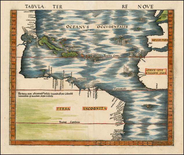
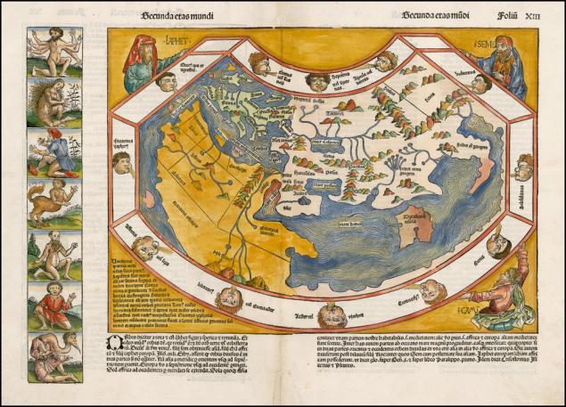
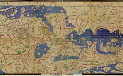
It looked like the world before Columbus. 1493, Admiral has not yet returned to Spain, and therefore not on the map of the West the way to India. There Arabia, India, something like China, Africa, the Ural Mountains, and some very scanty Europe. Keep the card Japheth, Shem, and Ham, and in the fields - mythical peoples, legless centaurs and other many-eyed monster. Psiglavtsev somehow not.
But the beginning of the 16th century. Columbus and his followers returned with detailed outline of the island of Hispaniola (Cuba) and the east coast of America (indeed, some of the words had not yet been invented).
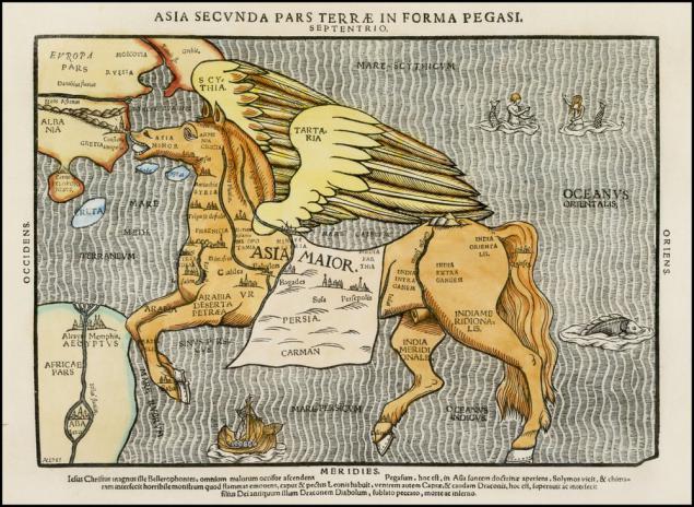
Nostrum mappers antiquity - to depict the world as an allegory. Asia - a pegasus. China - is the tail. Istanbul - horse nostril. Northern India and Pakistan - you know that.
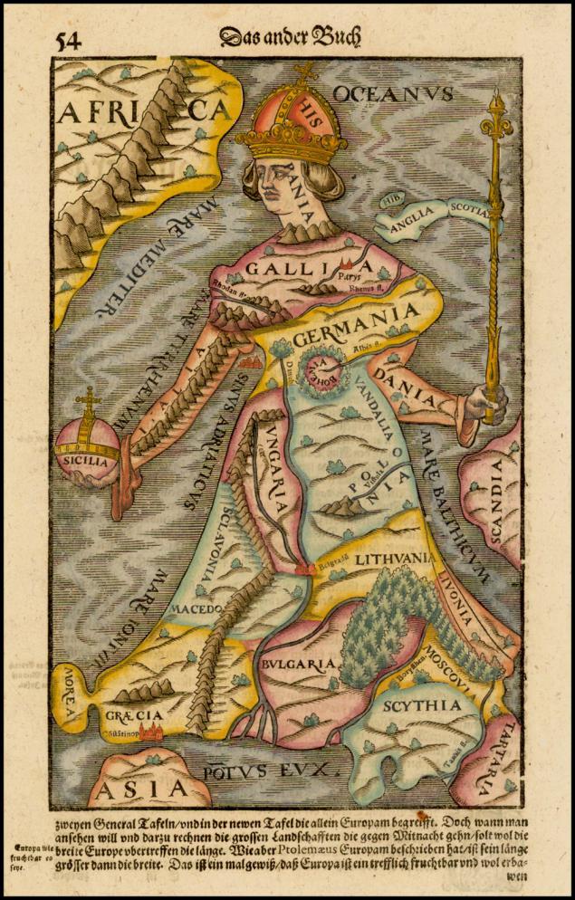
In fact, the card in the form of living beings were drawn not from ignorance. It is investigated Europe can also be depicted as a queen. Spain - the crown (the most powerful country 16 - early 17th century, so that all this is no accident, Muscovy somewhere in the legs, a wonderful Bohemia (now Czech Republic) - whether the heart, or stomach).
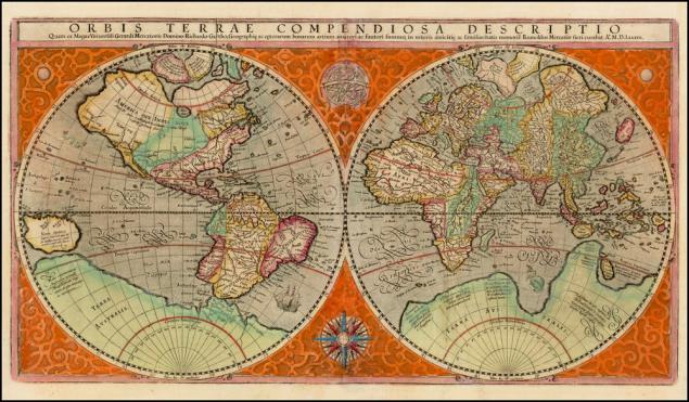
Amount of knowledge increases, cartography developed, and the world takes almost modern shape. This is the famous Orbis Terrae, Mercator globe, one of the inventors of modern cartography, the man who, in particular, gave the word "atlas" meaning - "a collection of cards." White spot in place of Antarctica, Australia yet, but the Mediterranean coast outlined extremely accurately. Incidentally, the Mediterranean Europeans explored the "from" and "to" in prehistoric times, but the same card with errors redraw almost two thousand years, from the time of Ptolemy.
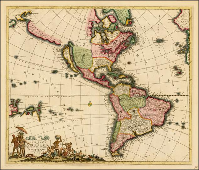
Map of America Nikolaus Visskhera 1658. A fairly accurate description of the east coast and throughout the Spanish in South America, but for some reason California is shown as an island. Sometimes involuntarily thought: there would be more interesting to live in the world corresponding to these cards?
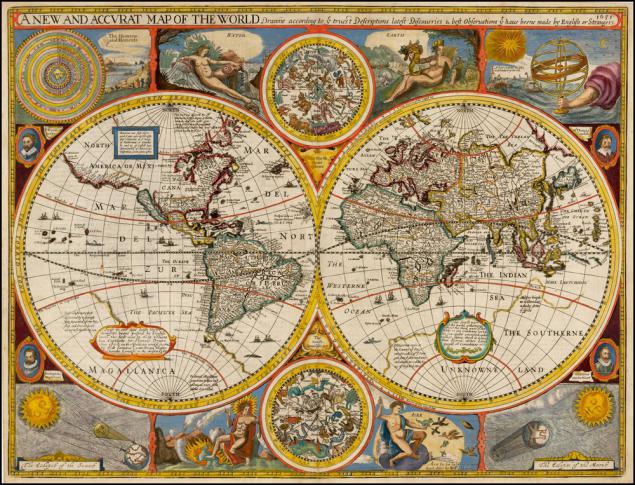
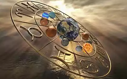
1651. "A new and accurate map of the world" virtually the same which appeared almost a hundred years before the Mercator map. Among other things, here are drawn four elements of alchemy planets, zodiac signs and the Lord's hand, which holds the solar system.
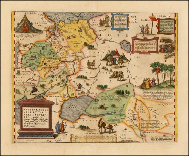
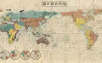
In fact, all these beautiful cards had more general educational character. Been there and traveled to other atlases, much less extensive and detailed. For example, on this map Rousseau, Muscovy and Tartary simply shows that somewhere north of the Black and Caspian Seas live Muscovites, which is surrounded on all sides by savage tribes - Tartarus, Samoyed, Molgomzaya and Biden and their camels. African humped, by the way, not two-humped Bactrian our Asian. This is one of the cards Abraham Ortelius, one of the greatest geographers, travelers and compilers of its time. Just about Russia he knew little more than about Australia.
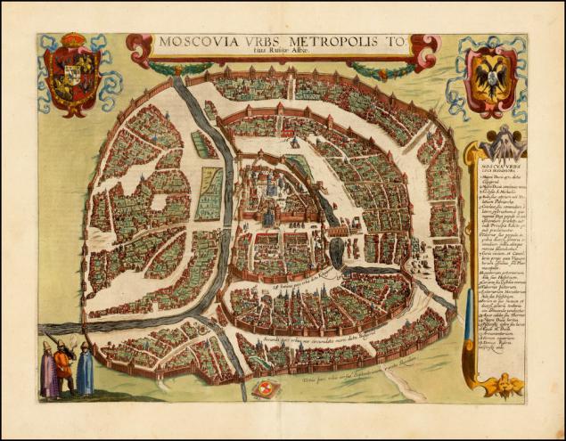
Sheet of satin world cities Civitates Orbis Terrarum Dutch Brown and Hogerberga .. Horizon swamped, north somehow right-bottom, but do not know the city impossible. In the center - the Kremlin, to the east of it - the wall of China-town, around - Belt White City (now Boulevard Ring), and another ring of walls - the current Garden. A little confusing river flowing envelope Kremlin and Moscow. This Neglinnaja, she's gravity. The river has been taken into the pipe at the beginning of the 19th century. But on this map shows that the Kuznetsk bridge and in fact was once a bridge.

But the beginning of the 16th century. Columbus and his followers returned with detailed outline of the island of Hispaniola (Cuba) and the east coast of America (indeed, some of the words had not yet been invented).

Nostrum mappers antiquity - to depict the world as an allegory. Asia - a pegasus. China - is the tail. Istanbul - horse nostril. Northern India and Pakistan - you know that.

In fact, the card in the form of living beings were drawn not from ignorance. It is investigated Europe can also be depicted as a queen. Spain - the crown (the most powerful country 16 - early 17th century, so that all this is no accident, Muscovy somewhere in the legs, a wonderful Bohemia (now Czech Republic) - whether the heart, or stomach).

Amount of knowledge increases, cartography developed, and the world takes almost modern shape. This is the famous Orbis Terrae, Mercator globe, one of the inventors of modern cartography, the man who, in particular, gave the word "atlas" meaning - "a collection of cards." White spot in place of Antarctica, Australia yet, but the Mediterranean coast outlined extremely accurately. Incidentally, the Mediterranean Europeans explored the "from" and "to" in prehistoric times, but the same card with errors redraw almost two thousand years, from the time of Ptolemy.

Map of America Nikolaus Visskhera 1658. A fairly accurate description of the east coast and throughout the Spanish in South America, but for some reason California is shown as an island. Sometimes involuntarily thought: there would be more interesting to live in the world corresponding to these cards?

1651. "A new and accurate map of the world" virtually the same which appeared almost a hundred years before the Mercator map. Among other things, here are drawn four elements of alchemy planets, zodiac signs and the Lord's hand, which holds the solar system.

In fact, all these beautiful cards had more general educational character. Been there and traveled to other atlases, much less extensive and detailed. For example, on this map Rousseau, Muscovy and Tartary simply shows that somewhere north of the Black and Caspian Seas live Muscovites, which is surrounded on all sides by savage tribes - Tartarus, Samoyed, Molgomzaya and Biden and their camels. African humped, by the way, not two-humped Bactrian our Asian. This is one of the cards Abraham Ortelius, one of the greatest geographers, travelers and compilers of its time. Just about Russia he knew little more than about Australia.

Sheet of satin world cities Civitates Orbis Terrarum Dutch Brown and Hogerberga .. Horizon swamped, north somehow right-bottom, but do not know the city impossible. In the center - the Kremlin, to the east of it - the wall of China-town, around - Belt White City (now Boulevard Ring), and another ring of walls - the current Garden. A little confusing river flowing envelope Kremlin and Moscow. This Neglinnaja, she's gravity. The river has been taken into the pipe at the beginning of the 19th century. But on this map shows that the Kuznetsk bridge and in fact was once a bridge.


30 things that took us online
Odessans - unique people. Their humor is certainly with what can not be confused!