768
Map Creator — relief map, the age of which 120 million years
The truth did not suffer from
if anyone recognizes her
The discovery, made by scientists of Bashkiria, contrary to the traditional views about human history. On a stone slab, whose age is about 120 million years, there is a relief map of the Ural region.
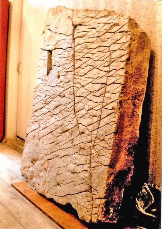
A stone slab found in the village of chandar. According to scientists, it is part of a relief map of the Ural region. Researchers believe that in the vicinity Chandara may be other portions of the map.
It may seem incredible. Scientists of Bashkir state University have found irrefutable evidence of the existence of an ancient advanced civilization. We are talking about was found in 1999, a huge stone slab with the image of the area, taken by an unknown method. This is a real relief map. About such have with the military. On a stone map shows the waterworks: a system of channels with a length of 12 thousand kilometers, dams, powerful dams. Near the channels marked with the diamond pad, the purpose of which is unclear. There are on the map and labels. Many inscriptions. At first thought it was old Chinese language. It turned out there. Signs hieroglyph-syllabic language of unknown origin, the reading until...
"The more I learn, the more you realize you know nothing", — says doctor of physical and mathematical Sciences, Professor Bashkir state University, Alexander Chuvyrov. It Chuvyrov made a sensational discovery. In 1995, the Professor and his graduate student from China Huang Hun decided to study the possible migration of Ancient China on the modern territory of Siberia and the Urals. In one of the expeditions to Bashkiria, they found several rock carvings done in old Chinese language, which confirmed the suspicion of Chinese immigrants. The inscription has been read. They mostly contained information about trade bargains, marriage registration and death.
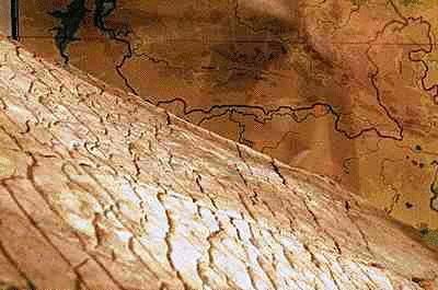
On a stone map, scientists were able to consider the shape of rivers, hills and waterworks. According to them, a depression in the center of the plate — ancient Ufa canyon, and later disappeared due to the movement of tectonic plates
However, in the process of scientific research in the archives of the Governor-General of Ufa found the notes Dating from the late eighteenth century. They said about two hundred unusual white stone slabs, supposedly located near the village of chandar nurimanovskiy district. The idea arose that these plates may have against the Chinese immigrants. Alexander Chuvyrov found in the archives also mention that in XVII-XVIII centuries, expeditions of Russian scientists who investigated Ural, recorded that they had examined 200 white slabs with signs and patterns, and in the early twentieth century, archaeologist A. Schmidt also had seen on the territory of Bashkiria six some white plates. This prompted the scientist to start the search. In 1998, having formed a team of his friends and students, Chuvyrov set to work. He hired a helicopter, the first expedition circled the places where allegedly there could be plate. But, despite all efforts to find the ancient slabs were not found. Desperate Chuvyrov thought that the existence of stone slabs — no more than a beautiful legend.
Good fortune came unexpectedly. During one of the visits to the village of chandar to Chuvirova approached the former Chairman of the local village Council, Vladimir Krainov, in the father's house which, by the way, stopped the archaeologist Schmidt: "You are here plate some are looking for? That is a strange plate lies." "At first I did not take this information seriously, says Chuvyrov, but still decided to go see it. I remember exactly this day, 21 July 1999. Under the porch of the house was a stove, but it had suffered some scratches. To get this plate for the two of us were clearly not under force, and I rushed for help to Ufa".
After a week in Candara work started. Digging up the slab, the searchers were amazed at its size: height — 148 cm, width — 106, thickness — 16. Its weight was no less than tons. The owner of the house for a few hours made out of wood with special rollers with which the plate and rolled out of the pit. The discovery has been called "dashkin Kamen" in honor of born on the eve of Alexander Chuvyrov granddaughter and transported to the University for research. Cleansed from the earth... and could not believe their eyes. "At first sight, says Chuvyrov, I realized that this is not just a piece of stone, but a real map, and also not simple, but voluminous. Yes, you see for yourself".
"How it was possible to identify the area? We initially thought did not allow that map to be so ancient. Fortunately, over many millions of years changes in topography of modern Bashkortostan are not global in nature. Easily recognizable Ufa height, while Ufa canyon is the most important point of our proof, because we carried out geological studies and found its track where it should be, according to the ancient map. Displacement of the canyon happened because of tectonic plates, nadvinetsya from the East. The group of Russian and Chinese specialists working in the field of cartography, physics, mathematics, Geology, geography, chemistry, and old Chinese language managed to make it on the stove caused volumetric map of the Ural region with rivers Belaya, Ufimka, Sutolka, Alexander Chuvyrov shows correspondents "Results" lines on the stone. On the map, look, we can clearly see Ufa canyon — the break of the earth's crust, stretching from Ufa to Sterlitamak. At the moment, the former river canyon Urshak. Here it is." The image on the plate surface is a map in scale 1:1.1 km.
Alexander Chuvyrov as a physicist used to trust only the facts and results of research. The facts today are as follows.
Managed to establish the geological composition of the plate. As it turned out, it consists of three layers. The base is 14 centimeters — is a solid dolomite. The second layer is perhaps the most interesting — and I want to say "made" of diopside glass. The technology of its processing is unknown to science. Actually, on this layer and applied the image. The third layer in 2 mm calcium porcelain protecting the map from external impact. "Special notice, says Professor Chuvyrov — that relief is on the stove in no case do not cut manually some ancient stonemason. It is simply impossible. It is obvious that the conducted machining of stone." X-ray analysis confirmed that the plate has an artificial origin and was created using some of the exact mechanisms.
At first, scientists thought that ancient slab may have a Chinese origin. Misled the vertical inscriptions on the map. As is known, the vertical script was used in the ancient Chinese language to the III century. Professor Chuvyrov to test this hypothesis, flew to China, where, not without difficulty, obtained permission to visit the Imperial library. 40 minutes allotted to him by the guardians to view rare books, he was convinced that the specimens vertical writing on the stone slab like nothing on one of the options of ancient Chinese writing. Meeting with colleagues from Hunan University finally buried the version about "Chinese track". Scientists concluded that the porcelain part of the plate in China has never been used. Also yielded nothing, and attempts to decipher the inscriptions, but managed to establish the nature of the letter — hieroglyph-syllabic. However, Chuvyrov says: "I think I was able to decipher a single icon on the map. He stands for the latitude of modern Ufa".
As the study of plate puzzles just added. The map is clearly visible to the huge irrigation system of the region is a miracle of engineering. In addition to rivers, shows two channel system width of 500 meters, 12 dams 300-500 meters wide, with a length of 10 kilometers and a depth of 3 km each. The dams were allowed to rotate the water in one direction or another, and for their creation has been moved more than a quadrillion cubic meters of earth. Compared to them, the Volga-don canal on the modern relief may seem like a scratch. As a physicist, Alexander Chuvyrov believes that in modern conditions, humanity is able to build only a small part of what is shown on the map. If you believe the map, the river White was initially artificial.
It was difficult to determine at least the approximate age of the plate. Held alternately radiocarbon analysis and scanning layers of uranium chronometer led to contradictory results and to clarify about the age of the plate is not made. During the inspection of the stone on the surface were found two sinks. Age of one of them — Navicopsina munitus of Gyrodeidae family — is about 50 million years, and the second — Ecculiomphalus princeps subfamily Ecculiomphalinae — 120 million years. It is this age and it was adopted as a working version. "Maybe the map was created just at the time when the magnetic pole of the Earth was in the modern area of Franz Josef, and it was just about 120 million years ago — says Professor Chuvyrov. — What appeared in front of us, is beyond of traditional perception of mankind and requires long-term habituation. We also got used to our miracle. At first, we believed that the stone is somewhere around 3000 years. Gradually, this age was postponed until, not yet identified shells, are embedded in the plate to denote some objects. And who can guarantee that the shell was embedded in the layer of plate is still alive? Maybe the Creator used a petrified find? And if so, the age of the plate might be older".
What could be a giant map? And here begins perhaps the most interesting. Materials of the Bashkir find were already studies in the Center of historical cartography in the American state of Wisconsin. The Americans were amazed. According to them, such three-dimensional map has only one purpose — navigation, and can be made exclusively for aerospace survey. Moreover, it is now in the United States are working on the project of creating such a three-dimensional map of the world. And it is planned to complete this work only to 2010! The fact that in the preparation of three-dimensional maps needs to handle a huge array of numbers. "Try to oscarthegrouch at least one mountain, says Chuvyrov, is crazy! The technology of compiling such maps demands super-computers and aerospace imagery with Shuttle. Who, then, created a map? Himself Chuvyrov, speaking about the unknown cartographers, is cautious: "I don't like when they start talking about some aliens, aliens. Let's call the person who made the map simply — the Creator.“
Probably those who then lived and built, flew — no roads on the map. Or use waterways. There is the assumption that the authors of the ancient map did not live here, and prepared a place for future settlement, draining his land. This we can say with a high degree of confidence, but of course, nothing can assert unequivocally. Why not assume that the authors of the maps might be people of some pre-existing civilization?
A recent study "card Creator" bring sensation after sensation. Scientists have no doubts that found in Kandare plate — only a small fragment of a large map of the Earth. It is believed that only fragments was 348. It is not excluded that there may be other fragments of the map. In the vicinity of Chandara, the scientists took over 400 samples of the soil and found out that most likely the whole map was located in the gorge of Sokolinaya Gora. However, during the ice age tore her to pieces. If the "mosaic" will be able to rebuild, according to scientists, the size of the stone maps should be about 340 by 340 meters. Once again immersed in the study of archival materials, Chuvyrov have been able to approximate the location of four fragments. One can hide under the rural house in Candara, the other in the same village under the former house of merchant Khasanov, the third under one of the village baths, the fourth — under the bridge support the local narrow gauge railway.
Meanwhile, Bashkir scientists hit the ground running and try, as they say, to "stake a claim". Send information about the discovery of the largest scientific centers of the world, spoke at several international conferences with a presentation on the topic: "Map of waterworks is unknown civilizations of the southern Urals".
From what I have found the Bashkir scientists, the earth is not unique. However, with one exception. When research was in full swing on the table to the Professor Chuvyrov got a small stone — chalcedony, to which were applied the same relief that was found on the plate. Perhaps someone who saw the stove, I decided to copy the relief. But who did it and why — is also a big mystery. History "Mishkinogo stone" continues... posted
Source: alexfl.ru/vechnoe/vechnoe_ist1.html
if anyone recognizes her
The discovery, made by scientists of Bashkiria, contrary to the traditional views about human history. On a stone slab, whose age is about 120 million years, there is a relief map of the Ural region.

A stone slab found in the village of chandar. According to scientists, it is part of a relief map of the Ural region. Researchers believe that in the vicinity Chandara may be other portions of the map.
It may seem incredible. Scientists of Bashkir state University have found irrefutable evidence of the existence of an ancient advanced civilization. We are talking about was found in 1999, a huge stone slab with the image of the area, taken by an unknown method. This is a real relief map. About such have with the military. On a stone map shows the waterworks: a system of channels with a length of 12 thousand kilometers, dams, powerful dams. Near the channels marked with the diamond pad, the purpose of which is unclear. There are on the map and labels. Many inscriptions. At first thought it was old Chinese language. It turned out there. Signs hieroglyph-syllabic language of unknown origin, the reading until...
"The more I learn, the more you realize you know nothing", — says doctor of physical and mathematical Sciences, Professor Bashkir state University, Alexander Chuvyrov. It Chuvyrov made a sensational discovery. In 1995, the Professor and his graduate student from China Huang Hun decided to study the possible migration of Ancient China on the modern territory of Siberia and the Urals. In one of the expeditions to Bashkiria, they found several rock carvings done in old Chinese language, which confirmed the suspicion of Chinese immigrants. The inscription has been read. They mostly contained information about trade bargains, marriage registration and death.

On a stone map, scientists were able to consider the shape of rivers, hills and waterworks. According to them, a depression in the center of the plate — ancient Ufa canyon, and later disappeared due to the movement of tectonic plates
However, in the process of scientific research in the archives of the Governor-General of Ufa found the notes Dating from the late eighteenth century. They said about two hundred unusual white stone slabs, supposedly located near the village of chandar nurimanovskiy district. The idea arose that these plates may have against the Chinese immigrants. Alexander Chuvyrov found in the archives also mention that in XVII-XVIII centuries, expeditions of Russian scientists who investigated Ural, recorded that they had examined 200 white slabs with signs and patterns, and in the early twentieth century, archaeologist A. Schmidt also had seen on the territory of Bashkiria six some white plates. This prompted the scientist to start the search. In 1998, having formed a team of his friends and students, Chuvyrov set to work. He hired a helicopter, the first expedition circled the places where allegedly there could be plate. But, despite all efforts to find the ancient slabs were not found. Desperate Chuvyrov thought that the existence of stone slabs — no more than a beautiful legend.
Good fortune came unexpectedly. During one of the visits to the village of chandar to Chuvirova approached the former Chairman of the local village Council, Vladimir Krainov, in the father's house which, by the way, stopped the archaeologist Schmidt: "You are here plate some are looking for? That is a strange plate lies." "At first I did not take this information seriously, says Chuvyrov, but still decided to go see it. I remember exactly this day, 21 July 1999. Under the porch of the house was a stove, but it had suffered some scratches. To get this plate for the two of us were clearly not under force, and I rushed for help to Ufa".
After a week in Candara work started. Digging up the slab, the searchers were amazed at its size: height — 148 cm, width — 106, thickness — 16. Its weight was no less than tons. The owner of the house for a few hours made out of wood with special rollers with which the plate and rolled out of the pit. The discovery has been called "dashkin Kamen" in honor of born on the eve of Alexander Chuvyrov granddaughter and transported to the University for research. Cleansed from the earth... and could not believe their eyes. "At first sight, says Chuvyrov, I realized that this is not just a piece of stone, but a real map, and also not simple, but voluminous. Yes, you see for yourself".
"How it was possible to identify the area? We initially thought did not allow that map to be so ancient. Fortunately, over many millions of years changes in topography of modern Bashkortostan are not global in nature. Easily recognizable Ufa height, while Ufa canyon is the most important point of our proof, because we carried out geological studies and found its track where it should be, according to the ancient map. Displacement of the canyon happened because of tectonic plates, nadvinetsya from the East. The group of Russian and Chinese specialists working in the field of cartography, physics, mathematics, Geology, geography, chemistry, and old Chinese language managed to make it on the stove caused volumetric map of the Ural region with rivers Belaya, Ufimka, Sutolka, Alexander Chuvyrov shows correspondents "Results" lines on the stone. On the map, look, we can clearly see Ufa canyon — the break of the earth's crust, stretching from Ufa to Sterlitamak. At the moment, the former river canyon Urshak. Here it is." The image on the plate surface is a map in scale 1:1.1 km.
Alexander Chuvyrov as a physicist used to trust only the facts and results of research. The facts today are as follows.
Managed to establish the geological composition of the plate. As it turned out, it consists of three layers. The base is 14 centimeters — is a solid dolomite. The second layer is perhaps the most interesting — and I want to say "made" of diopside glass. The technology of its processing is unknown to science. Actually, on this layer and applied the image. The third layer in 2 mm calcium porcelain protecting the map from external impact. "Special notice, says Professor Chuvyrov — that relief is on the stove in no case do not cut manually some ancient stonemason. It is simply impossible. It is obvious that the conducted machining of stone." X-ray analysis confirmed that the plate has an artificial origin and was created using some of the exact mechanisms.
At first, scientists thought that ancient slab may have a Chinese origin. Misled the vertical inscriptions on the map. As is known, the vertical script was used in the ancient Chinese language to the III century. Professor Chuvyrov to test this hypothesis, flew to China, where, not without difficulty, obtained permission to visit the Imperial library. 40 minutes allotted to him by the guardians to view rare books, he was convinced that the specimens vertical writing on the stone slab like nothing on one of the options of ancient Chinese writing. Meeting with colleagues from Hunan University finally buried the version about "Chinese track". Scientists concluded that the porcelain part of the plate in China has never been used. Also yielded nothing, and attempts to decipher the inscriptions, but managed to establish the nature of the letter — hieroglyph-syllabic. However, Chuvyrov says: "I think I was able to decipher a single icon on the map. He stands for the latitude of modern Ufa".
As the study of plate puzzles just added. The map is clearly visible to the huge irrigation system of the region is a miracle of engineering. In addition to rivers, shows two channel system width of 500 meters, 12 dams 300-500 meters wide, with a length of 10 kilometers and a depth of 3 km each. The dams were allowed to rotate the water in one direction or another, and for their creation has been moved more than a quadrillion cubic meters of earth. Compared to them, the Volga-don canal on the modern relief may seem like a scratch. As a physicist, Alexander Chuvyrov believes that in modern conditions, humanity is able to build only a small part of what is shown on the map. If you believe the map, the river White was initially artificial.
It was difficult to determine at least the approximate age of the plate. Held alternately radiocarbon analysis and scanning layers of uranium chronometer led to contradictory results and to clarify about the age of the plate is not made. During the inspection of the stone on the surface were found two sinks. Age of one of them — Navicopsina munitus of Gyrodeidae family — is about 50 million years, and the second — Ecculiomphalus princeps subfamily Ecculiomphalinae — 120 million years. It is this age and it was adopted as a working version. "Maybe the map was created just at the time when the magnetic pole of the Earth was in the modern area of Franz Josef, and it was just about 120 million years ago — says Professor Chuvyrov. — What appeared in front of us, is beyond of traditional perception of mankind and requires long-term habituation. We also got used to our miracle. At first, we believed that the stone is somewhere around 3000 years. Gradually, this age was postponed until, not yet identified shells, are embedded in the plate to denote some objects. And who can guarantee that the shell was embedded in the layer of plate is still alive? Maybe the Creator used a petrified find? And if so, the age of the plate might be older".
What could be a giant map? And here begins perhaps the most interesting. Materials of the Bashkir find were already studies in the Center of historical cartography in the American state of Wisconsin. The Americans were amazed. According to them, such three-dimensional map has only one purpose — navigation, and can be made exclusively for aerospace survey. Moreover, it is now in the United States are working on the project of creating such a three-dimensional map of the world. And it is planned to complete this work only to 2010! The fact that in the preparation of three-dimensional maps needs to handle a huge array of numbers. "Try to oscarthegrouch at least one mountain, says Chuvyrov, is crazy! The technology of compiling such maps demands super-computers and aerospace imagery with Shuttle. Who, then, created a map? Himself Chuvyrov, speaking about the unknown cartographers, is cautious: "I don't like when they start talking about some aliens, aliens. Let's call the person who made the map simply — the Creator.“
Probably those who then lived and built, flew — no roads on the map. Or use waterways. There is the assumption that the authors of the ancient map did not live here, and prepared a place for future settlement, draining his land. This we can say with a high degree of confidence, but of course, nothing can assert unequivocally. Why not assume that the authors of the maps might be people of some pre-existing civilization?
A recent study "card Creator" bring sensation after sensation. Scientists have no doubts that found in Kandare plate — only a small fragment of a large map of the Earth. It is believed that only fragments was 348. It is not excluded that there may be other fragments of the map. In the vicinity of Chandara, the scientists took over 400 samples of the soil and found out that most likely the whole map was located in the gorge of Sokolinaya Gora. However, during the ice age tore her to pieces. If the "mosaic" will be able to rebuild, according to scientists, the size of the stone maps should be about 340 by 340 meters. Once again immersed in the study of archival materials, Chuvyrov have been able to approximate the location of four fragments. One can hide under the rural house in Candara, the other in the same village under the former house of merchant Khasanov, the third under one of the village baths, the fourth — under the bridge support the local narrow gauge railway.
Meanwhile, Bashkir scientists hit the ground running and try, as they say, to "stake a claim". Send information about the discovery of the largest scientific centers of the world, spoke at several international conferences with a presentation on the topic: "Map of waterworks is unknown civilizations of the southern Urals".
From what I have found the Bashkir scientists, the earth is not unique. However, with one exception. When research was in full swing on the table to the Professor Chuvyrov got a small stone — chalcedony, to which were applied the same relief that was found on the plate. Perhaps someone who saw the stove, I decided to copy the relief. But who did it and why — is also a big mystery. History "Mishkinogo stone" continues... posted
Source: alexfl.ru/vechnoe/vechnoe_ist1.html
How to change the opinion of the person on the opposite
How scientists make vanilla from cow dung and 17 other interesting facts about fragrances

