1156
Russia! We have much to be proud of!
I decided I'm here to show you a small, composed his own, a compilation of what we, the Russians, can be proud of living in our vast country. And the fact that the one negative sentiment we have, especially on the eve of the election ... Everything, everything is no policy ... and proud look. 11 show interest, and then break, comment and criticize if you want. And best enhanced by the fact that I missed or did not know. I push you in search of something interesting and beautiful on our open spaces.
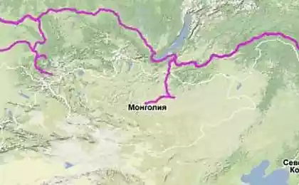
We begin, of course, the most important thing - the country itself. So Russia.
All lovers of geography from the school even knew that the Soviet Union - the largest country in the world and an area of one-sixth of the entire land area of the Earth. But that was not the Soviet Union, and Russia, to take his place, much less. But all the same, namely the Russian Federation on the area of its territory - the largest country in the world. Her area of more than 17 million square kilometers. These dimensions make it the nature of the country, the climate is surprisingly diverse. The largest country has eleven time zones, has borders with eighteen countries in the world, sub-tropical climatic zones begin and end in the Arctic. And more than half of the territory of Russia, is permafrost. All this is a unique achievement, due to the huge size of Rossii.Bolee half the territory of Russia occupies Siberia. No country in the world can not compete in size with Siberia. It is thanks to her, Russia has enormous natural wealth. Siberian natural landscapes amazing in its beauty. Taiga - a symbol both of Siberia and Russia. The total length of Russia's borders with neighboring countries is over sixty thousand kilometers, more than twenty thousand - suhoputnye.V Russia live longer than in other countries, different peoples and nationalities. Total of more than one hundred and eighty. Did you know that the largest swamp in the world is located in Russia. And yet it is so.
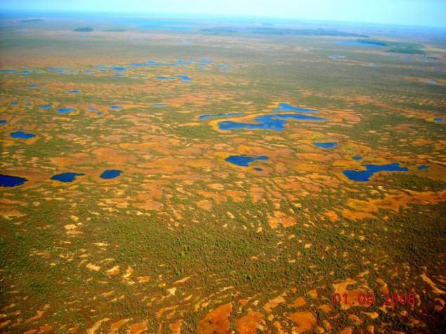
In the heart of the Siberian Federal District stretches Great Vasyugan swamp. The name is no accident: it is the largest swamp in the world. Its area is 53,000 square kilometers, stretches from west to east - 573 kilometers from north to south - 320 km. In such a space fit to safely state or Switzerland, for example, the Voronezh region. Vasyugan swamp is located in Tomsk, Omsk and Novosibirsk regions, between large Siberian rivers Ob and Irtysh.
Swamps contain vast reserves of peat and counteract the greenhouse effect, by linking carbon. Explored reserves of peat account for more than 1 billion tons, the average depth - 2 to 4 m, maximum - 10 m.
The most important function of the marshes - the purification of the atmosphere, for what it called a giant natural filter. Peat bog absorbs toxic substances carbon binds and thus prevents the greenhouse effect saturates the air with oxygen.
How can we ignore our Baikal!
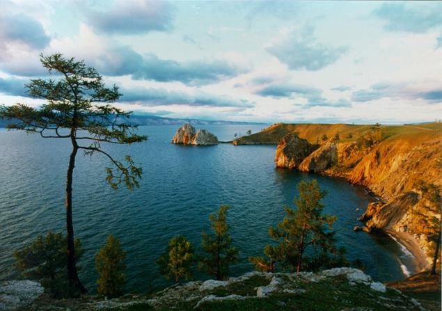
Lake Baikal - the lake of tectonic origin in the southern part of Eastern Siberia, the deepest lake in the world's largest natural reservoir of fresh water.
The width of the lake ranges from 24 to 79 km. The bottom of the lake at 1167 meters below sea level, and the mirror of its waters - at 453 meters above.
The water surface area of Lake Baikal - 31,722 square kilometers (excluding islands), which is approximately equal to the area of countries such as Belgium, the Netherlands or Denmark. In the area of water surface Baikal ranks sixth among the largest lakes in the world.
The length of coastline - 2100 km.
Lake Baikal - the deepest lake in the world. The current value of the maximum depth of the lake - 1642 m
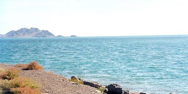
Baikal is the largest freshwater lake of our planet, but just the Caspian Sea is the largest lake in the world, named for the large size of the sea. Its area without islands 368 thousand sq. Kilometers. The Caspian Sea contains 90% water of saline lakes in the world.
The length of the Caspian Sea from north to south - about 1200 kilometers (36 ° 34'-47 ° 13 'N), from west to east - from 195 to 435 kilometers, an average of 310-320 kilometers. The area of the Caspian Sea at present - approximately 371,000 square kilometers, the maximum depth - 1025 m.
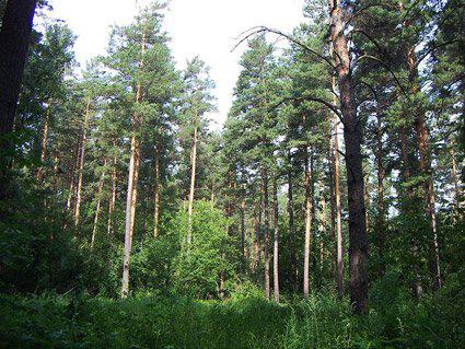
Do we still have this famous Siberian taiga.
Siberian taiga is the largest forest on the planet Earth. It is several times larger than even the Amazon jungle. Siberian taiga stretches a long strip south from the Arctic Circle. The width of this band between the zone and the temperate climate of the Arctic tundra reaches 1,300 kilometers.
Taiga zone on the territory of the Russian Federation begins approximately at the latitude of St. Petersburg. Further, this great forest stretches north of Moscow to the Urals, after - to Novosibirsk, up to the Far East. Taiga forest covered mountains of the Urals, the Baikal region, the Altai, the entire Eastern and Western Siberia and other large areas. According to local residents, the distances are measured in the forest not kilometers, and transitions. This is not surprising, because in Eurasia that forest covers an area of more than fifty million hectares. Taiga is a zone of coniferous trees such as fir, spruce, pine, larch, cedar.
Despite the huge area occupied by taiga, its fauna bednovato. Although it is much richer fauna of the tundra. Here is a little above ground herd animals, which, however, is true for other sites. The taiga is it because of the taiga forest stand it prevents animals to notify each other of approaching danger. At the same time, in the Siberian taiga animals pretty good conditions, many of them have never seen a man and forced to defend themselves only on the natural enemies of the animal world.
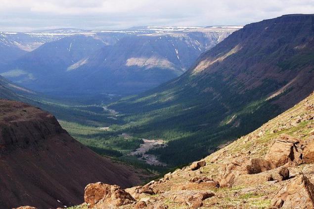
Putorana Plateau.
Putorana Plateau - is the northernmost and one of the oldest in the world, the plateau of volcanic origin. Its area is 2 million hectares. Located south of the plateau to the east of the Taimyr Peninsula and the largest city in the polar world - Norilsk. We can confidently say that this is one of the most wild and little-known places on earth.
Putorana Plateau - a country of canyons and waterfalls. Virtually every tributary of the creek and found several waterfalls. Even large rivers can not cope with the strength and hardness of basalt bases, forming powerful waterfalls and canyons. It is the largest concentration of waterfalls in Russia, including the largest. The main part of the Putorana Plateau stretches from north to south and 650 kilometers in the southern part of the Taimyr Peninsula. The plateau covers over 250 thousand square kilometers, occupying part of the extensive "rectangle", formed by the rivers Yenisei Kureyka, Lower Tunguska, and Heth Kotui. Putorana Plateau dismembered flat-bottomed canyons with steep vertical slopes, in places the height of several hundred meters. Numerous rivers and streams form the highest plateau and beautiful waterfalls in Russia, there are more than 1, 5 thousand. In these places it is the highest in the Central Siberian Plateau Stone Mountain - 1701 meters. On the plateau, there are about 9000 lakes, many of which are striking in their depth, for example Khantayskoye - up to 520 meters. To a large lake, which affects its beauty also include Lama and Heth.
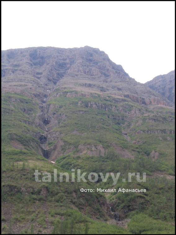
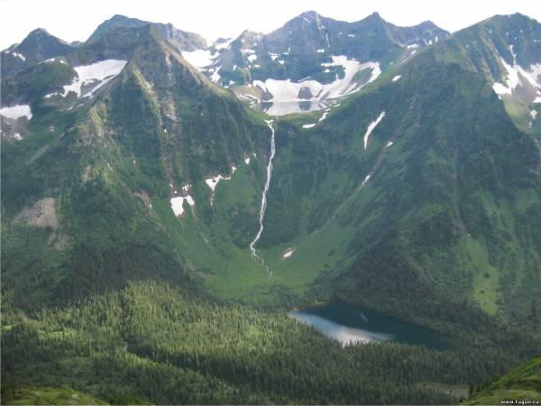
Waterfall willow.
Willow - the highest waterfall in Eurasia. Located on the plateau Putorana (Central Siberian Plateau) in the national park "Putoransky" Dyupkun on the lake, on the left bank of it, between the mouths of the 1st loons and loon 2nd. The stream drops steeply from the flat mountain "KEYSTONE" from the shoreline about 920 m asl and reaches the lake's edge with 109 m asl
Willow - a 15-step waterfall in the mouth r.Talnikovoy (Putorana Plateau) summmarnoy a height of more than 600 m.
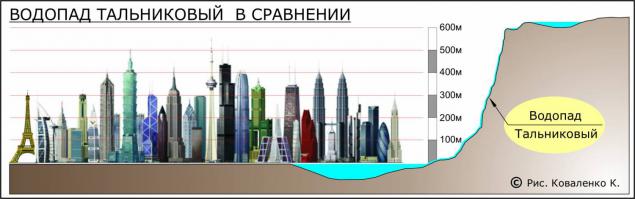
No photos of good quality as willow it is difficult to reach. And the few photos that were made were made when the water in it was a little bit.
Waterfall Kinzelyuksky. (had the honor to visit it!)
Kinzelyuk Waterfall - the second highest waterfall in Asia and Russia (after the willow waterfall at Putorana Plateau). It located in Tofalaria, in a remote mountainous region (Eastern Sayan). It flows out of the lake, located in the circus peak Kinzelyuksky (biceps). Overall height (stage) - 328 m, height of free fall of water - 90 m.
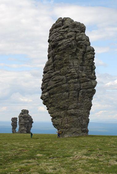
Pillars of weathering on the plateau of Man-Pupu-nёr.
The top of the ridge Man-Pupu-nёr decorated with original pieces - remnants of ancient weathered schists. No they are not sculpted, not grind, they created an infinitely long time - for 200 million years! Frost weathering. Buttes 7, the height from 30 to 42 m.
Buttes on the plateau of Man-Pupu-nёr, or as they are called, "Mansi idiots" are the pillars of weathering. This geological monument is located in the Trinity-Pechersk district of Komi, in the area between Ichotlyagi and Pechora. The height of the poles of 30 to 42 meters.
It is associated with numerous legends. Once Pillars of weathering were objects of worship Mansi. In connection with the mysterious origin of these pillars of the local population - Mansi, Komi and Russian - have created many legends about their appearance.
One of them is described in the book by Professor Vera Varsanofevoy "Life of the mountains", "Voguls, wandering here with their herds of reindeer, they say that these stone pillars were once seven giants, Samoyeds, who walked through the mountains to Siberia to destroy Vogulsky people. But when they reached the top, now called Man-Pupu-nёr, their leader - the shaman saw a Yalping-nёr - Vogulsky sacred mountain.
Horrified, he threw his drum, which fell on a high conical peak, rising to the south of Man-Pupu-called Koypom Nyorai and that means in Vogulsky drum. And the shaman and all his companions were petrified with fear ».
There is another version of the appearance of column. Six mighty giants chased one of the tribes, the Mansi, leaving behind stone belt of the Ural Mountains. The origins of the Pechora River to pass giants had almost caught up with the tribe. But they blocked the path of the shaman with a little white, lime, face and turned the Giants in six stone pillars. Since then, every shaman of the tribe Mansi necessarily come to the sacred tract and drew from it a magical power.
Trans-Siberian Railway.
Trans-Siberian, Trans-Siberian Railway (modern names) or Great Siberian Way (historical name) - a well-equipped track across the continent, connecting the Trans-Siberian Railway - Yablonovy pass European Russia, its largest industrial areas and the capital Moscow with its middle (Siberia) and eastern (Far East) areas. This is the road that binds Russia - a country that stretched on 10 time zones into a single economic organism, and most importantly, in the common military-strategic space. If it had not been built at the time, then very likely, Russia will hardly be kept for a Far East and the Pacific - but she was able to keep Alaska, not associated with the Russian Empire stable means of communication. Transsiberian - it is also a road that gave impetus to the development of eastern areas and involved a them in the economic life of the rest of the vast country.
Some think that the term "Transsib" should be interpreted as a way of connecting the Urals and the Far East, and literally passing "through" Siberia (Trans-Siberian). But this contradicts the state of affairs and does not reflect the true value of this line. And the name? The name gave us the English, dubbed the path is not «Great Siberian Way», as it should have been a literal translation from the Russian, and the «Trans-Siberian Railway» - and then it caught on and rooted in the speech.
And now the "Transsib" as a geopolitical concept makes sense as a way of connecting Center and Pacific Ocean, Moscow and Vladivostok, and more - as a way of connecting ports of West and the capital of Russia, as well as access to Europe (Moscow, Saint-Petersburg, Brest, Kaliningrad) to the ports of East and exits to Asia (Vladivostok, Nakhodka, Vanino, Zabaikalsk); and not the local path interconnecting the Urals and the Far East.
The actual length of the Trans-Siberian railway by the main passenger way (from Moscow to Vladivostok) of 9288, 2 km and by this indicator, it is the longest in the world, crossing by land almost all Eurasia. Tariff length (which is calculated on the price of tickets) is somewhat more - 9298 km and does not coincide with the real. There are several parallel cargo rounds at different sites. Track width on the Trans-Siberian railway - 1,520 mm.
Transsib crosses the territory of 12 regions, 5 territories, 2 republics, 1 autonomous region and 1 district of the region of the Russian Federation and its 87 cities are located.
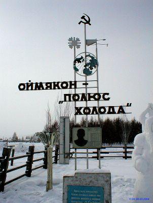
On its way Transsib crosses 16 major rivers: Volga, Vyatka, Kama, Tobol, Irtysh, Ob, the Tom, the Chulym, the Yenisey, the Oka, the Selenga, Zeya, Bureya, Amur, Khor and Ussuri; over 207 km runs along Lake Baikal and 39 km along the banks of the Amur Bay, Sea of Japan. Pole of Cold.
An amazing natural phenomenon - cold pole - is located in the countryside Oymyakon Tomtor district (ulus) of Yakutia. Worldwide, there are no more places at such low temperatures are constantly people live and work.
The average monthly temperature in January is minus 61 degrees Celsius and the coldest days is minus 68.
The village Tomtor located at 2,000 meters above sea level in the trough beautiful Verkhoyansk Mountains. It was here in 1924, Academician Sergei Obruchev was recorded the lowest temperature for our hemisphere - 71, 2 degrees Celsius.
Here, at a latitude that is just a little north of the latitude of Petrozavodsk, winter temperatures are far superior cold in other parts of the Earth, including the Arctic Circle and at the geographic pole. Temperatures below 60 degrees Celsius are here almost every January and in August can be a plus 30 and minus 15.
Posted in [mergetime] 1330276075 [/ mergetime]
All! More I do not have. Complement
Source:
We begin, of course, the most important thing - the country itself. So Russia.
All lovers of geography from the school even knew that the Soviet Union - the largest country in the world and an area of one-sixth of the entire land area of the Earth. But that was not the Soviet Union, and Russia, to take his place, much less. But all the same, namely the Russian Federation on the area of its territory - the largest country in the world. Her area of more than 17 million square kilometers. These dimensions make it the nature of the country, the climate is surprisingly diverse. The largest country has eleven time zones, has borders with eighteen countries in the world, sub-tropical climatic zones begin and end in the Arctic. And more than half of the territory of Russia, is permafrost. All this is a unique achievement, due to the huge size of Rossii.Bolee half the territory of Russia occupies Siberia. No country in the world can not compete in size with Siberia. It is thanks to her, Russia has enormous natural wealth. Siberian natural landscapes amazing in its beauty. Taiga - a symbol both of Siberia and Russia. The total length of Russia's borders with neighboring countries is over sixty thousand kilometers, more than twenty thousand - suhoputnye.V Russia live longer than in other countries, different peoples and nationalities. Total of more than one hundred and eighty. Did you know that the largest swamp in the world is located in Russia. And yet it is so.
In the heart of the Siberian Federal District stretches Great Vasyugan swamp. The name is no accident: it is the largest swamp in the world. Its area is 53,000 square kilometers, stretches from west to east - 573 kilometers from north to south - 320 km. In such a space fit to safely state or Switzerland, for example, the Voronezh region. Vasyugan swamp is located in Tomsk, Omsk and Novosibirsk regions, between large Siberian rivers Ob and Irtysh.
Swamps contain vast reserves of peat and counteract the greenhouse effect, by linking carbon. Explored reserves of peat account for more than 1 billion tons, the average depth - 2 to 4 m, maximum - 10 m.
The most important function of the marshes - the purification of the atmosphere, for what it called a giant natural filter. Peat bog absorbs toxic substances carbon binds and thus prevents the greenhouse effect saturates the air with oxygen.

How can we ignore our Baikal!
Lake Baikal - the lake of tectonic origin in the southern part of Eastern Siberia, the deepest lake in the world's largest natural reservoir of fresh water.
The width of the lake ranges from 24 to 79 km. The bottom of the lake at 1167 meters below sea level, and the mirror of its waters - at 453 meters above.
The water surface area of Lake Baikal - 31,722 square kilometers (excluding islands), which is approximately equal to the area of countries such as Belgium, the Netherlands or Denmark. In the area of water surface Baikal ranks sixth among the largest lakes in the world.
The length of coastline - 2100 km.
Lake Baikal - the deepest lake in the world. The current value of the maximum depth of the lake - 1642 m

Baikal is the largest freshwater lake of our planet, but just the Caspian Sea is the largest lake in the world, named for the large size of the sea. Its area without islands 368 thousand sq. Kilometers. The Caspian Sea contains 90% water of saline lakes in the world.
The length of the Caspian Sea from north to south - about 1200 kilometers (36 ° 34'-47 ° 13 'N), from west to east - from 195 to 435 kilometers, an average of 310-320 kilometers. The area of the Caspian Sea at present - approximately 371,000 square kilometers, the maximum depth - 1025 m.

Do we still have this famous Siberian taiga.
Siberian taiga is the largest forest on the planet Earth. It is several times larger than even the Amazon jungle. Siberian taiga stretches a long strip south from the Arctic Circle. The width of this band between the zone and the temperate climate of the Arctic tundra reaches 1,300 kilometers.
Taiga zone on the territory of the Russian Federation begins approximately at the latitude of St. Petersburg. Further, this great forest stretches north of Moscow to the Urals, after - to Novosibirsk, up to the Far East. Taiga forest covered mountains of the Urals, the Baikal region, the Altai, the entire Eastern and Western Siberia and other large areas. According to local residents, the distances are measured in the forest not kilometers, and transitions. This is not surprising, because in Eurasia that forest covers an area of more than fifty million hectares. Taiga is a zone of coniferous trees such as fir, spruce, pine, larch, cedar.
Despite the huge area occupied by taiga, its fauna bednovato. Although it is much richer fauna of the tundra. Here is a little above ground herd animals, which, however, is true for other sites. The taiga is it because of the taiga forest stand it prevents animals to notify each other of approaching danger. At the same time, in the Siberian taiga animals pretty good conditions, many of them have never seen a man and forced to defend themselves only on the natural enemies of the animal world.

Putorana Plateau.
Putorana Plateau - is the northernmost and one of the oldest in the world, the plateau of volcanic origin. Its area is 2 million hectares. Located south of the plateau to the east of the Taimyr Peninsula and the largest city in the polar world - Norilsk. We can confidently say that this is one of the most wild and little-known places on earth.
Putorana Plateau - a country of canyons and waterfalls. Virtually every tributary of the creek and found several waterfalls. Even large rivers can not cope with the strength and hardness of basalt bases, forming powerful waterfalls and canyons. It is the largest concentration of waterfalls in Russia, including the largest. The main part of the Putorana Plateau stretches from north to south and 650 kilometers in the southern part of the Taimyr Peninsula. The plateau covers over 250 thousand square kilometers, occupying part of the extensive "rectangle", formed by the rivers Yenisei Kureyka, Lower Tunguska, and Heth Kotui. Putorana Plateau dismembered flat-bottomed canyons with steep vertical slopes, in places the height of several hundred meters. Numerous rivers and streams form the highest plateau and beautiful waterfalls in Russia, there are more than 1, 5 thousand. In these places it is the highest in the Central Siberian Plateau Stone Mountain - 1701 meters. On the plateau, there are about 9000 lakes, many of which are striking in their depth, for example Khantayskoye - up to 520 meters. To a large lake, which affects its beauty also include Lama and Heth.

Waterfall willow.
Willow - the highest waterfall in Eurasia. Located on the plateau Putorana (Central Siberian Plateau) in the national park "Putoransky" Dyupkun on the lake, on the left bank of it, between the mouths of the 1st loons and loon 2nd. The stream drops steeply from the flat mountain "KEYSTONE" from the shoreline about 920 m asl and reaches the lake's edge with 109 m asl
Willow - a 15-step waterfall in the mouth r.Talnikovoy (Putorana Plateau) summmarnoy a height of more than 600 m.

No photos of good quality as willow it is difficult to reach. And the few photos that were made were made when the water in it was a little bit.

Waterfall Kinzelyuksky. (had the honor to visit it!)
Kinzelyuk Waterfall - the second highest waterfall in Asia and Russia (after the willow waterfall at Putorana Plateau). It located in Tofalaria, in a remote mountainous region (Eastern Sayan). It flows out of the lake, located in the circus peak Kinzelyuksky (biceps). Overall height (stage) - 328 m, height of free fall of water - 90 m.

Pillars of weathering on the plateau of Man-Pupu-nёr.
The top of the ridge Man-Pupu-nёr decorated with original pieces - remnants of ancient weathered schists. No they are not sculpted, not grind, they created an infinitely long time - for 200 million years! Frost weathering. Buttes 7, the height from 30 to 42 m.
Buttes on the plateau of Man-Pupu-nёr, or as they are called, "Mansi idiots" are the pillars of weathering. This geological monument is located in the Trinity-Pechersk district of Komi, in the area between Ichotlyagi and Pechora. The height of the poles of 30 to 42 meters.
It is associated with numerous legends. Once Pillars of weathering were objects of worship Mansi. In connection with the mysterious origin of these pillars of the local population - Mansi, Komi and Russian - have created many legends about their appearance.
One of them is described in the book by Professor Vera Varsanofevoy "Life of the mountains", "Voguls, wandering here with their herds of reindeer, they say that these stone pillars were once seven giants, Samoyeds, who walked through the mountains to Siberia to destroy Vogulsky people. But when they reached the top, now called Man-Pupu-nёr, their leader - the shaman saw a Yalping-nёr - Vogulsky sacred mountain.
Horrified, he threw his drum, which fell on a high conical peak, rising to the south of Man-Pupu-called Koypom Nyorai and that means in Vogulsky drum. And the shaman and all his companions were petrified with fear ».
There is another version of the appearance of column. Six mighty giants chased one of the tribes, the Mansi, leaving behind stone belt of the Ural Mountains. The origins of the Pechora River to pass giants had almost caught up with the tribe. But they blocked the path of the shaman with a little white, lime, face and turned the Giants in six stone pillars. Since then, every shaman of the tribe Mansi necessarily come to the sacred tract and drew from it a magical power.

Trans-Siberian Railway.
Trans-Siberian, Trans-Siberian Railway (modern names) or Great Siberian Way (historical name) - a well-equipped track across the continent, connecting the Trans-Siberian Railway - Yablonovy pass European Russia, its largest industrial areas and the capital Moscow with its middle (Siberia) and eastern (Far East) areas. This is the road that binds Russia - a country that stretched on 10 time zones into a single economic organism, and most importantly, in the common military-strategic space. If it had not been built at the time, then very likely, Russia will hardly be kept for a Far East and the Pacific - but she was able to keep Alaska, not associated with the Russian Empire stable means of communication. Transsiberian - it is also a road that gave impetus to the development of eastern areas and involved a them in the economic life of the rest of the vast country.
Some think that the term "Transsib" should be interpreted as a way of connecting the Urals and the Far East, and literally passing "through" Siberia (Trans-Siberian). But this contradicts the state of affairs and does not reflect the true value of this line. And the name? The name gave us the English, dubbed the path is not «Great Siberian Way», as it should have been a literal translation from the Russian, and the «Trans-Siberian Railway» - and then it caught on and rooted in the speech.
And now the "Transsib" as a geopolitical concept makes sense as a way of connecting Center and Pacific Ocean, Moscow and Vladivostok, and more - as a way of connecting ports of West and the capital of Russia, as well as access to Europe (Moscow, Saint-Petersburg, Brest, Kaliningrad) to the ports of East and exits to Asia (Vladivostok, Nakhodka, Vanino, Zabaikalsk); and not the local path interconnecting the Urals and the Far East.
The actual length of the Trans-Siberian railway by the main passenger way (from Moscow to Vladivostok) of 9288, 2 km and by this indicator, it is the longest in the world, crossing by land almost all Eurasia. Tariff length (which is calculated on the price of tickets) is somewhat more - 9298 km and does not coincide with the real. There are several parallel cargo rounds at different sites. Track width on the Trans-Siberian railway - 1,520 mm.
Transsib crosses the territory of 12 regions, 5 territories, 2 republics, 1 autonomous region and 1 district of the region of the Russian Federation and its 87 cities are located.
On its way Transsib crosses 16 major rivers: Volga, Vyatka, Kama, Tobol, Irtysh, Ob, the Tom, the Chulym, the Yenisey, the Oka, the Selenga, Zeya, Bureya, Amur, Khor and Ussuri; over 207 km runs along Lake Baikal and 39 km along the banks of the Amur Bay, Sea of Japan. Pole of Cold.
An amazing natural phenomenon - cold pole - is located in the countryside Oymyakon Tomtor district (ulus) of Yakutia. Worldwide, there are no more places at such low temperatures are constantly people live and work.
The average monthly temperature in January is minus 61 degrees Celsius and the coldest days is minus 68.
The village Tomtor located at 2,000 meters above sea level in the trough beautiful Verkhoyansk Mountains. It was here in 1924, Academician Sergei Obruchev was recorded the lowest temperature for our hemisphere - 71, 2 degrees Celsius.
Here, at a latitude that is just a little north of the latitude of Petrozavodsk, winter temperatures are far superior cold in other parts of the Earth, including the Arctic Circle and at the geographic pole. Temperatures below 60 degrees Celsius are here almost every January and in August can be a plus 30 and minus 15.
Posted in [mergetime] 1330276075 [/ mergetime]
All! More I do not have. Complement

Source: