874
Path "Moon-1"
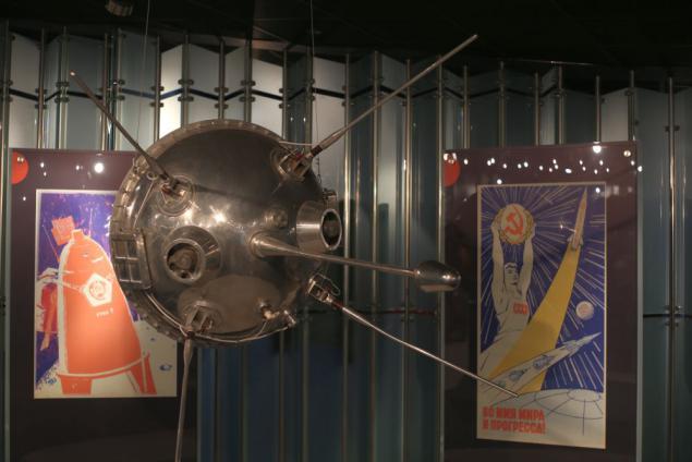
January 2, 1959 in the flight went station Luna 1. It was the first station reached escape velocity and the first station flown by the moon. According to its devices showed that the moon and no magnetic field was opened solar wind. Even the fact that she has not got to the moon because of an error is now perceived as a plus. Because of this it intact now flies in its orbit between Earth and Mars.
Well, I decided to try to restore its flight trajectory on archival materials.
Scientists and engineers that prepared TASS obviously encountered an unexpected problem. How to specify the coordinates of the station during the flight? Her flight was covered in great detail and specify the coordinates required so that anyone could find in the sky point at which the Earth's envoy is in space. Astronomers decided to show the coordinates in right ascension and declination (the analog of latitude and longitude on the Earth), but here they are poorly suited. They are good only to indicate a very, very distant objects. As a result, it was decided not to tie the coordinates to the sky and the Earth. And indicates which of the above points of the station will be at a given time and at what altitude.
To control the path and positioning using an automated system designed to determine the trajectory of ballistic missiles
Scan the surface of the Earth looked like:
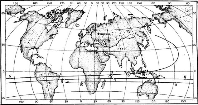
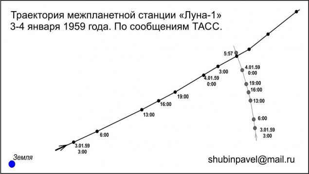
And if you gather all the information from the TASS can distinguish such points
January 3 in
3:00: 3 degrees 12 minutes S latitude and 108 degrees east 100,000 miles from Earth [1]
6:00: 4 degrees 30 minutes S latitude and 63.5 degrees east 137,000 km from the Earth [3]
13 hours 7 minutes 33 degrees S and 40 degrees W The 209 000 km from the Earth [4]
16 hours: 8 degrees 20 minutes and 86 S (85) degrees W The 237,000 km from Earth
19 hours 8 minutes 57 degrees S and 131 (130) 265 000 W The degree km from the Earth [5]
21 hours 9 minutes 18 degrees S and 160 degrees W The 284 000 km from the Earth [6]
January 4
0 hours: 9 degrees 45 minutes S latitude and 155 degrees VD 311 000 km from Earth
3:00: 10 degrees 7 minutes and 110 degrees S VD 336 600 km from Earth
At 5 o'clock 57 minutes missile has been at a minimum distance from the Moon (5-6 thousand km) and has become a satellite of the Sun [7]. After that TASS was publish its coordinates in astronomical coordinates. Although part of the coordinates, as shown in the diagram, and have been translated into terrestrial
January 5 at 10:00 boarded her batteries and the relationship with her ended.
A few comments. In brackets number of similar points marked on a map of the Earth.
Two brackets are labeled more accurate coordinates. Simple data analysis it appeared that they noticeably stand out from the overall path. It seems that the message was a mistake TASS 1 degree west longitude.
Knowing these data and the speed of rotation of the Earth, you can rearrange them in the three-dimensional coordinates, and then visualize the trajectory.
I, having received such a trajectory
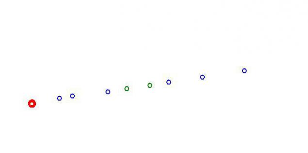
The flight path is very large and I had a long time to "play" with coefficients in order to show the curvature of the trajectory. Got this picture
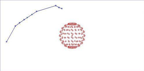
The second point of this scheme significantly distracting. I just tried to take into account also the time of launch artificial sodium comet. Unfortunately, due to cloud cover over the USSR in the time (it is photographed only one Observatory), as well as due to the fact that the dust in the course, only 10% of the sodium, the coordinates are not very accurate.
Slightly processed result, I drew a diagram:
Overall, quite clearly seen as the station and the moon moving in the place of their meeting. And if you carefully examine the trajectory of "Moon-1" can be seen bending and after meeting her with the moon. The gravitational field of the Moon is enough to change its trajectory, so it could be seen even on a rough diagram.
Source: habrahabr.ru/post/228763/
Well, I decided to try to restore its flight trajectory on archival materials.

Scientists and engineers that prepared TASS obviously encountered an unexpected problem. How to specify the coordinates of the station during the flight? Her flight was covered in great detail and specify the coordinates required so that anyone could find in the sky point at which the Earth's envoy is in space. Astronomers decided to show the coordinates in right ascension and declination (the analog of latitude and longitude on the Earth), but here they are poorly suited. They are good only to indicate a very, very distant objects. As a result, it was decided not to tie the coordinates to the sky and the Earth. And indicates which of the above points of the station will be at a given time and at what altitude.
To control the path and positioning using an automated system designed to determine the trajectory of ballistic missiles
Scan the surface of the Earth looked like:

And if you gather all the information from the TASS can distinguish such points
January 3 in
3:00: 3 degrees 12 minutes S latitude and 108 degrees east 100,000 miles from Earth [1]
6:00: 4 degrees 30 minutes S latitude and 63.5 degrees east 137,000 km from the Earth [3]
13 hours 7 minutes 33 degrees S and 40 degrees W The 209 000 km from the Earth [4]
16 hours: 8 degrees 20 minutes and 86 S (85) degrees W The 237,000 km from Earth
19 hours 8 minutes 57 degrees S and 131 (130) 265 000 W The degree km from the Earth [5]
21 hours 9 minutes 18 degrees S and 160 degrees W The 284 000 km from the Earth [6]
January 4
0 hours: 9 degrees 45 minutes S latitude and 155 degrees VD 311 000 km from Earth
3:00: 10 degrees 7 minutes and 110 degrees S VD 336 600 km from Earth
At 5 o'clock 57 minutes missile has been at a minimum distance from the Moon (5-6 thousand km) and has become a satellite of the Sun [7]. After that TASS was publish its coordinates in astronomical coordinates. Although part of the coordinates, as shown in the diagram, and have been translated into terrestrial
January 5 at 10:00 boarded her batteries and the relationship with her ended.
A few comments. In brackets number of similar points marked on a map of the Earth.
Two brackets are labeled more accurate coordinates. Simple data analysis it appeared that they noticeably stand out from the overall path. It seems that the message was a mistake TASS 1 degree west longitude.
Knowing these data and the speed of rotation of the Earth, you can rearrange them in the three-dimensional coordinates, and then visualize the trajectory.
I, having received such a trajectory

The flight path is very large and I had a long time to "play" with coefficients in order to show the curvature of the trajectory. Got this picture

The second point of this scheme significantly distracting. I just tried to take into account also the time of launch artificial sodium comet. Unfortunately, due to cloud cover over the USSR in the time (it is photographed only one Observatory), as well as due to the fact that the dust in the course, only 10% of the sodium, the coordinates are not very accurate.
Slightly processed result, I drew a diagram:

Overall, quite clearly seen as the station and the moon moving in the place of their meeting. And if you carefully examine the trajectory of "Moon-1" can be seen bending and after meeting her with the moon. The gravitational field of the Moon is enough to change its trajectory, so it could be seen even on a rough diagram.
Source: habrahabr.ru/post/228763/


The Big Bang Theory, on screen and in life
Chinese scientists hope to send the improved version of its rover on Mars