1946
10 images taken with the help of Google Earth
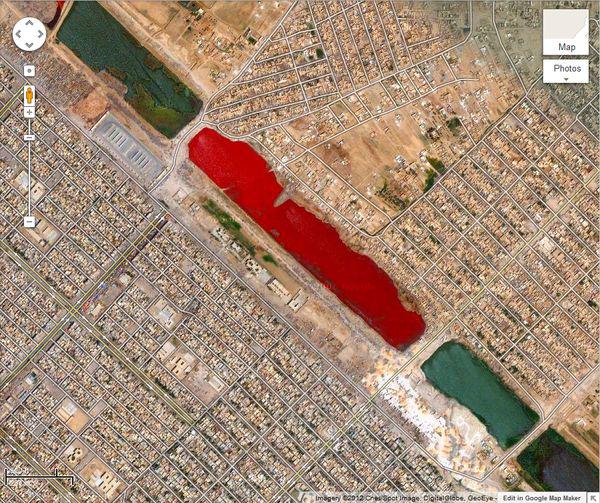
Something similar to the bloody lake is located in Iraq, near the town of Sadr City, the coordinates: 33.396157 ° N, 44.486926 ° E No official explanation for this exotic color of the water was not given yet.
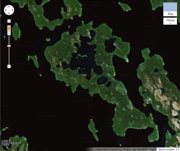
Unique natural phenomenon - an island in the lake, which is located on the island, which is still in one lake, which again is on the island - a long and narrow strip of land in northern Canada. Its coordinates: 69.793 ° N, 108.241 ° E All this matryoshka of islands and lakes uninhabitable and if not map Google Earth, one for a long time would not pay any attention to her strange configuration.
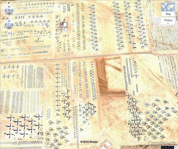
The cemetery is laid out on planes 32 08'59.96 "N, 110 50'09.03" E near the city of Tucson (Arizona). Here you can find almost any aircraft, the former armed US since World War II.
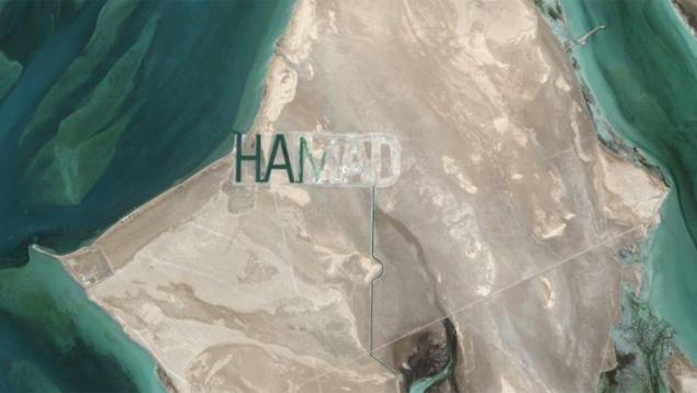
Arab sheikh Hamad bin Hamdan Al Nahyan told to cut his name on the sandy surface of their island Al Futaisi in the Persian Gulf, near Abu Dhabi. HAMAD letters clearly visible from space and today is considered the largest word on the planet. Usually written in the sand words quickly smoothed out, but not in this case - of the giant letters form the navigable channels, which do not allow the name of Sheikh disappear.
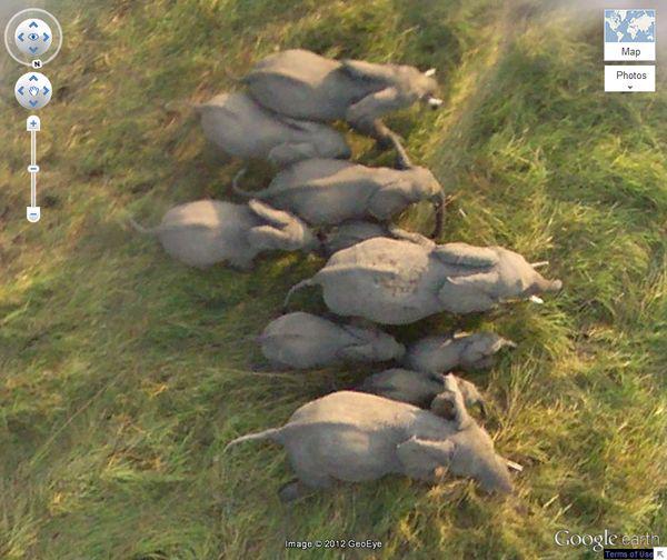
Thanks to satellites, now you can easily watch the animals in the wild. This herd of elephants was filmed at 10.903497 north latitude, 19.93229 E
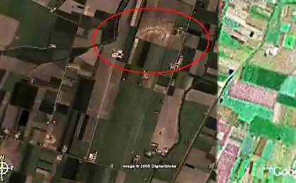
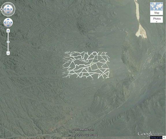
These mysterious structure and broken lines were found using Google Earth in the Gobi desert (China). According to experts, it is a secret military base, and the strange structure, most likely could be used for weapons testing, calibration spy satellites and radar testing.
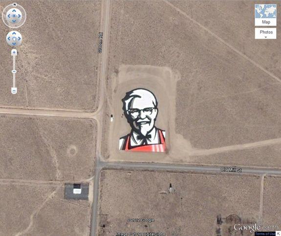
Considering how many people each day exploring the planet with the help of maps Google, it is possible that in this advertisement and makes sense. And this giant KFC ads in Nevada is not a unique case - the logo of Coca-Cola, for example, clearly visible from space on a hillside in Chile. It was made from 70,000 empty bottles of Coke. Portrait of Colonel Sanders takes more than eight thousand square meters, its coordinates are 37.646163 ° N, 115.750819 E
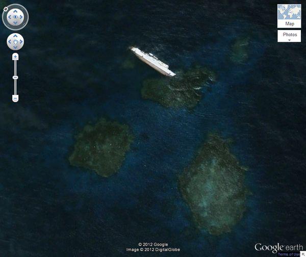
Bolivian cargo ship sank off the coast of Sudan in 2003. This is the largest wreck (81 meters in length), which can be seen using Google Earth. Coordinates: 19 ° 38 '46.00 "N, 37 ° 17' 42.00" E
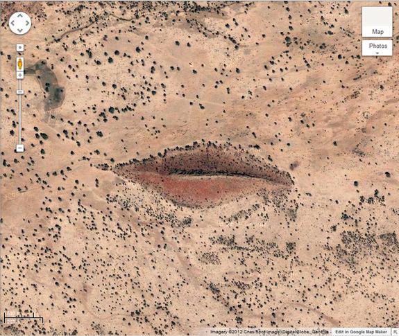
This "kiss the earth" shaped hills Sudan. Coordinates: 12 ° 22'13.32 "N, 23 ° 19'20.18" E
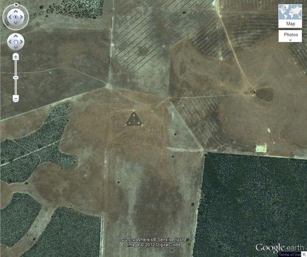
In Australia, 30 ° 30'38.44 "north latitude 115 ° 22'56.03" VD. was discovered a strange triangle with bright points of light. Ufologists immediately decided that it was an alien ship. Other users have suggested that this may be an antenna, somehow related to the wind farm located nearby, which is controlled remotely. Triangle can send and receive control signals.

Unique natural phenomenon - an island in the lake, which is located on the island, which is still in one lake, which again is on the island - a long and narrow strip of land in northern Canada. Its coordinates: 69.793 ° N, 108.241 ° E All this matryoshka of islands and lakes uninhabitable and if not map Google Earth, one for a long time would not pay any attention to her strange configuration.

The cemetery is laid out on planes 32 08'59.96 "N, 110 50'09.03" E near the city of Tucson (Arizona). Here you can find almost any aircraft, the former armed US since World War II.

Arab sheikh Hamad bin Hamdan Al Nahyan told to cut his name on the sandy surface of their island Al Futaisi in the Persian Gulf, near Abu Dhabi. HAMAD letters clearly visible from space and today is considered the largest word on the planet. Usually written in the sand words quickly smoothed out, but not in this case - of the giant letters form the navigable channels, which do not allow the name of Sheikh disappear.

Thanks to satellites, now you can easily watch the animals in the wild. This herd of elephants was filmed at 10.903497 north latitude, 19.93229 E

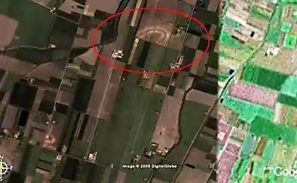
These mysterious structure and broken lines were found using Google Earth in the Gobi desert (China). According to experts, it is a secret military base, and the strange structure, most likely could be used for weapons testing, calibration spy satellites and radar testing.

Considering how many people each day exploring the planet with the help of maps Google, it is possible that in this advertisement and makes sense. And this giant KFC ads in Nevada is not a unique case - the logo of Coca-Cola, for example, clearly visible from space on a hillside in Chile. It was made from 70,000 empty bottles of Coke. Portrait of Colonel Sanders takes more than eight thousand square meters, its coordinates are 37.646163 ° N, 115.750819 E

Bolivian cargo ship sank off the coast of Sudan in 2003. This is the largest wreck (81 meters in length), which can be seen using Google Earth. Coordinates: 19 ° 38 '46.00 "N, 37 ° 17' 42.00" E

This "kiss the earth" shaped hills Sudan. Coordinates: 12 ° 22'13.32 "N, 23 ° 19'20.18" E

In Australia, 30 ° 30'38.44 "north latitude 115 ° 22'56.03" VD. was discovered a strange triangle with bright points of light. Ufologists immediately decided that it was an alien ship. Other users have suggested that this may be an antenna, somehow related to the wind farm located nearby, which is controlled remotely. Triangle can send and receive control signals.