946
Virtual City: why GIS has not yet turned the world of architecture
This article is about the city and architecture. Although about beautiful houses there will be nothing. On them was a bit in the previous article and, alas, it distracted attention from the actual information component and sent a discussion into the mainstream discussion of 3D-models cities - and geographic information systems (GIS), which in one form or another this model offer or provide the opportunity to participate in the simulation. Thus, two- and three-dimensional GIS sorts of innumerable. Why, then, GIS has not yet led to a revolution in urban planning?
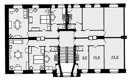
First, let's talk about why the architecture and construction should be approached more responsibly than it is now accepted. The fact is that in addition to building design, architect job is to plan people's lives. You every day gradually manages the city you go, and go on to trace someone streets, live in placed with some mysterious calculation houses and even a park bench someone in this place set on purpose. The architecture of all time quietly makes you do something within the usual life, but it is possible to encode and something new, and you accept it without even noticing. For example, designing a bathroom in each apartment houses changed the way of life of tens of millions of people. You would be surprised to see an innovative residential project "improved planning '30s, when it was assumed that to wash once or twice a week is enough public bath and laundry plant, the toilet is in each apartment at the time was the technical and cultural breakthrough.
Typical section of the Moscow City Council, the plan fragment 1925
Modern life is changing rapidly, and design goes with her in the leg. Of course, you will not find the drawing board, roll of tracing paper and blueprint table. They were replaced by many CAD (Computer Aided Design). Instead of mascara bottles, gouache and watercolor - a program for 3D-modeling and photorealistic rendering. Calculations are not conducted on a slide rule, a special software package that extracts data from three-dimensional models. Algorithms have become more complex, accuracy and reliability - above
.
But it's all - quantitative rather than qualitative changes. Yes, they have transformed the daily work process, but the decision-making mechanism remains the same. Sometimes, no analysis is not carried out at all, but the arguments may be the level of "well let's wrong" and "will then look pretty on the map." The economic rationale is attracted by the ears: "We have built ten years ago, almost the size of a swimming pool in the town of N-sk, and it paid off at X percent of Y years, so just index the price." To extract relevant information - to voluntarily bring down an avalanche of incomprehensible calculations on his head. And the majority of stakeholders are satisfied with this situation, although there are just epically failed project.
Thus, the general plans of cities developing architects from the standpoint of beauty lines, their understanding of the convenience of life and intuition. Evaluate and approve the projects managers and economists, who are important figures balance areas, the expected costs and benefits. And consumers protection, the inhabitants, does this situation usually does not affect, and they do not even come to mind that could influence.
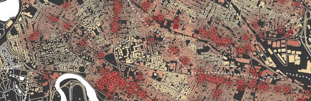
Somehow it looks promising master plan. Different colors - this is where it has already built or to be built, for example, housing, park or offices. Then he developed a detailed project with an explanatory note, which occupies an entire wardrobe - on paper, of course
.
Compared obviously it wins constantly updated geoinformation model. Not just a 3D-map, but actually the information system. Where can the mouse to select a group of houses and find out how many people live there. Where on the map marked with all institutions and establishments with their bandwidth and target audience. Where can I learn the averaged vehicle traffic on any street at any hour. Where measured noise or air pollution at some point turns into a public figure in the plan of the city, not in a trance in the same day, a piece of paper in a dusty folder. Alas, money and labor to be invested right here and now, and is expected to return "somewhere out there", so the GIS design come very slowly and unevenly.
Simulate in 3D thousands of unremarkable buildings - do not very interesting task, but it can be trusted to automation only very tentatively. Mainly engaged in this or lovers, then the result is accessible to all, but the quality is not too high, or private companies, developers, suitable to business professional - but they share the fruits of labor are in no hurry
.
https://player.vimeo.com/video/70447799 video>
Here is the private commercial 3D-model of San Francisco from the company, which may for media project to put the score at half a million of American money, and private developer - did not hesitate to pay this bill
.
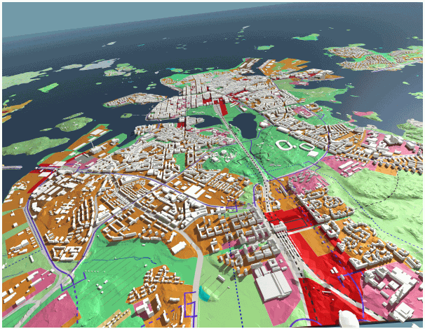
Anyway, gradually created a complete virtual model of an existing material (but, alas, not social) space. While it is quite fragmented, but continuously updated avalanche. Very often the only well developed city center or some symbolic objects, and the rest are created automatically or non-existent, but there are examples of the "carpet" coverage, for example, Berlin, with its 550 000 modeled buildings. But this is "a three-dimensional map," and not information system. With the rest, not so visible and attractive to fans of the flow of information is worse.
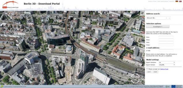
Berlin model, which can be downloaded bit by bit for the local operation. I have so much wealth but as a student!
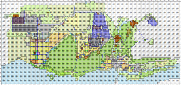
Smaller in size, but more sophisticated and multifaceted projects launched in Helsinki and Montreal-based systems, "Bentley MicroStation" and "Bentley Map". The model covers the city underground and surface infrastructure and developed using laser scanning technology. For terrestrial infrastructure of measurement used aerial lidar survey, for tunnels - terrestrial lidar survey. On the resulting model synchronizes all possible municipal documentation and correspondence on the property. It also carried out the allocation of plots for construction. Its effectiveness has proven that GIS in engineering projects related to high-density complex infrastructure of the city center. Alas, the design tools on the "Bentley Systems" and stand as a Bentley, so I did not have to see them even with one eye. Little more can be read article .
City of Helsinki, Finland, City Survey Division - 3D Municipal Information System. Suffice multidisciplinary GIS, judging from public sources.
The former Soviet Union the whole construction is subject to government regulation, and therefore the GIS must be consecrated bureaucratic procedures. All that requires government support and the organization generally works very slowly, but gradually the individual projects are emerging in Russia. For example, the creation of a single (two-dimensional) geoinformation system Tyumen region, which is recognized as the best regional IT-Project 2015 competition «Global CIO» . In addition, it allows outside developers to create their own commercial GIS services based on open data concept. Another example: recently completed electronic map underground utilities Khabarovsk, which was created by several organizations for 10 years (in words: ten years). Probably lasted so long, "transfer to digital," because to update the information of the Soviet period, when the reality may be different from the existing plan for the tens of meters - a hell of a job. Illustration of personal experience: I once met a Soviet nedokumentirovannny cable (presumably due) with a diameter of 15 centimeters, extending right through the building through the basement and leaving through the opposite wall in the direction of the white spots on topographic surveying with a modest inscription "Special Structures»
.
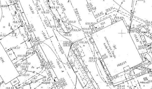
Paper topographic survey, a small piece, that you were just the scale of the tragedy. These lines represent something very important and mostly invisible.
The problem is, even the few existing in Russia and the CIS integrated GIS is being used formally, just as replacing paper maps, layouts and folders with reports, and not for the modeling and analysis of variant branches and optimization of results. The reality is usually offered and accepted only option plan, the quality of which depends on the talent, experience, competence and credibility of the developers. In addition, all the countless retreats "only in exceptional cases" is usually taken in the field without the consent of the authors, does not affect the project, and he's less correlated with reality. GIS, even two-dimensional, this problem resolves potential.
But what are these "branches", and why they are needed, and if it works without them? Back in the 60s came up with Malysz Pole Boleslaw threshold analysis. In short, when the city's development along the old path becomes clearly inefficient, too expensive or limited by a barrier such as a river or railway, it is necessary not to change tactics and strategy. To "pass the threshold," at the same time need more resources, and is not expected to return at once, so to make a mistake at this stage is impossible. Select several possible fundamentally different new ways of development for them is based the forecast on expenses and profits on a dozen or two years in advance, and selects the most profitable at the moment the way in which the development and goes to the next moment of stagnation. GIS - ideal for the realization of this method. But it should be much more mathematize system than those who are now, and analysis tools must be different. Ideally, the virtual city should have its own AI (or call it an active expert system), and who is able to offer, and to evaluate apparently disparate options.
I was able to find the information on the application of mathematical modeling of spatial development in Russia in XXI century only to Togliatti (2001), and Yakutsk (2003) using the system "LandUse" a > TSNIIP urban development, which gradually developed since the mid-70s.
The result looks like gridovaya map of existing and planned use of the area based on the calculated values of the many parameters of each square of land. The mathematical model requires the input of the card gridovye statyschmilёnov razyh data types, with the number and types of parameters and necessary step grid is calculated each time individually. With conventional GIS software package, of course, is not compatible.
Thus, the problems of urban use of modern GIS that are separate two-dimensional wide-model separately three-dimensional little information, they are in a large number of competing and not always compatible programs and formats, with the majority of them are not "official document" and they can not be openly used by designers. These systems do not support a time component, and therefore, do not allow retrospective analysis of the territory, to simulate the likely future state and to compare them. The number of "slices of information" virtual city is still not enough to quantitative change to qualitative passed. But progress does not stand still, and sooner or later the city will become a full-fledged virtual tool of the process of urban planning, and perhaps one of the most active creators of their own.
Source: geektimes.ru/post/270854/

First, let's talk about why the architecture and construction should be approached more responsibly than it is now accepted. The fact is that in addition to building design, architect job is to plan people's lives. You every day gradually manages the city you go, and go on to trace someone streets, live in placed with some mysterious calculation houses and even a park bench someone in this place set on purpose. The architecture of all time quietly makes you do something within the usual life, but it is possible to encode and something new, and you accept it without even noticing. For example, designing a bathroom in each apartment houses changed the way of life of tens of millions of people. You would be surprised to see an innovative residential project "improved planning '30s, when it was assumed that to wash once or twice a week is enough public bath and laundry plant, the toilet is in each apartment at the time was the technical and cultural breakthrough.

Typical section of the Moscow City Council, the plan fragment 1925
Modern life is changing rapidly, and design goes with her in the leg. Of course, you will not find the drawing board, roll of tracing paper and blueprint table. They were replaced by many CAD (Computer Aided Design). Instead of mascara bottles, gouache and watercolor - a program for 3D-modeling and photorealistic rendering. Calculations are not conducted on a slide rule, a special software package that extracts data from three-dimensional models. Algorithms have become more complex, accuracy and reliability - above
.
But it's all - quantitative rather than qualitative changes. Yes, they have transformed the daily work process, but the decision-making mechanism remains the same. Sometimes, no analysis is not carried out at all, but the arguments may be the level of "well let's wrong" and "will then look pretty on the map." The economic rationale is attracted by the ears: "We have built ten years ago, almost the size of a swimming pool in the town of N-sk, and it paid off at X percent of Y years, so just index the price." To extract relevant information - to voluntarily bring down an avalanche of incomprehensible calculations on his head. And the majority of stakeholders are satisfied with this situation, although there are just epically failed project.
Thus, the general plans of cities developing architects from the standpoint of beauty lines, their understanding of the convenience of life and intuition. Evaluate and approve the projects managers and economists, who are important figures balance areas, the expected costs and benefits. And consumers protection, the inhabitants, does this situation usually does not affect, and they do not even come to mind that could influence.

Somehow it looks promising master plan. Different colors - this is where it has already built or to be built, for example, housing, park or offices. Then he developed a detailed project with an explanatory note, which occupies an entire wardrobe - on paper, of course
.
Compared obviously it wins constantly updated geoinformation model. Not just a 3D-map, but actually the information system. Where can the mouse to select a group of houses and find out how many people live there. Where on the map marked with all institutions and establishments with their bandwidth and target audience. Where can I learn the averaged vehicle traffic on any street at any hour. Where measured noise or air pollution at some point turns into a public figure in the plan of the city, not in a trance in the same day, a piece of paper in a dusty folder. Alas, money and labor to be invested right here and now, and is expected to return "somewhere out there", so the GIS design come very slowly and unevenly.
Simulate in 3D thousands of unremarkable buildings - do not very interesting task, but it can be trusted to automation only very tentatively. Mainly engaged in this or lovers, then the result is accessible to all, but the quality is not too high, or private companies, developers, suitable to business professional - but they share the fruits of labor are in no hurry
.
https://player.vimeo.com/video/70447799 video>
Here is the private commercial 3D-model of San Francisco from the company, which may for media project to put the score at half a million of American money, and private developer - did not hesitate to pay this bill
.
Anyway, gradually created a complete virtual model of an existing material (but, alas, not social) space. While it is quite fragmented, but continuously updated avalanche. Very often the only well developed city center or some symbolic objects, and the rest are created automatically or non-existent, but there are examples of the "carpet" coverage, for example, Berlin, with its 550 000 modeled buildings. But this is "a three-dimensional map," and not information system. With the rest, not so visible and attractive to fans of the flow of information is worse.

Berlin model, which can be downloaded bit by bit for the local operation. I have so much wealth but as a student!
Smaller in size, but more sophisticated and multifaceted projects launched in Helsinki and Montreal-based systems, "Bentley MicroStation" and "Bentley Map". The model covers the city underground and surface infrastructure and developed using laser scanning technology. For terrestrial infrastructure of measurement used aerial lidar survey, for tunnels - terrestrial lidar survey. On the resulting model synchronizes all possible municipal documentation and correspondence on the property. It also carried out the allocation of plots for construction. Its effectiveness has proven that GIS in engineering projects related to high-density complex infrastructure of the city center. Alas, the design tools on the "Bentley Systems" and stand as a Bentley, so I did not have to see them even with one eye. Little more can be read article .

City of Helsinki, Finland, City Survey Division - 3D Municipal Information System. Suffice multidisciplinary GIS, judging from public sources.
The former Soviet Union the whole construction is subject to government regulation, and therefore the GIS must be consecrated bureaucratic procedures. All that requires government support and the organization generally works very slowly, but gradually the individual projects are emerging in Russia. For example, the creation of a single (two-dimensional) geoinformation system Tyumen region, which is recognized as the best regional IT-Project 2015 competition «Global CIO» . In addition, it allows outside developers to create their own commercial GIS services based on open data concept. Another example: recently completed electronic map underground utilities Khabarovsk, which was created by several organizations for 10 years (in words: ten years). Probably lasted so long, "transfer to digital," because to update the information of the Soviet period, when the reality may be different from the existing plan for the tens of meters - a hell of a job. Illustration of personal experience: I once met a Soviet nedokumentirovannny cable (presumably due) with a diameter of 15 centimeters, extending right through the building through the basement and leaving through the opposite wall in the direction of the white spots on topographic surveying with a modest inscription "Special Structures»
.

Paper topographic survey, a small piece, that you were just the scale of the tragedy. These lines represent something very important and mostly invisible.
The problem is, even the few existing in Russia and the CIS integrated GIS is being used formally, just as replacing paper maps, layouts and folders with reports, and not for the modeling and analysis of variant branches and optimization of results. The reality is usually offered and accepted only option plan, the quality of which depends on the talent, experience, competence and credibility of the developers. In addition, all the countless retreats "only in exceptional cases" is usually taken in the field without the consent of the authors, does not affect the project, and he's less correlated with reality. GIS, even two-dimensional, this problem resolves potential.
But what are these "branches", and why they are needed, and if it works without them? Back in the 60s came up with Malysz Pole Boleslaw threshold analysis. In short, when the city's development along the old path becomes clearly inefficient, too expensive or limited by a barrier such as a river or railway, it is necessary not to change tactics and strategy. To "pass the threshold," at the same time need more resources, and is not expected to return at once, so to make a mistake at this stage is impossible. Select several possible fundamentally different new ways of development for them is based the forecast on expenses and profits on a dozen or two years in advance, and selects the most profitable at the moment the way in which the development and goes to the next moment of stagnation. GIS - ideal for the realization of this method. But it should be much more mathematize system than those who are now, and analysis tools must be different. Ideally, the virtual city should have its own AI (or call it an active expert system), and who is able to offer, and to evaluate apparently disparate options.
I was able to find the information on the application of mathematical modeling of spatial development in Russia in XXI century only to Togliatti (2001), and Yakutsk (2003) using the system "LandUse" a > TSNIIP urban development, which gradually developed since the mid-70s.

The result looks like gridovaya map of existing and planned use of the area based on the calculated values of the many parameters of each square of land. The mathematical model requires the input of the card gridovye statyschmilёnov razyh data types, with the number and types of parameters and necessary step grid is calculated each time individually. With conventional GIS software package, of course, is not compatible.
Thus, the problems of urban use of modern GIS that are separate two-dimensional wide-model separately three-dimensional little information, they are in a large number of competing and not always compatible programs and formats, with the majority of them are not "official document" and they can not be openly used by designers. These systems do not support a time component, and therefore, do not allow retrospective analysis of the territory, to simulate the likely future state and to compare them. The number of "slices of information" virtual city is still not enough to quantitative change to qualitative passed. But progress does not stand still, and sooner or later the city will become a full-fledged virtual tool of the process of urban planning, and perhaps one of the most active creators of their own.
Source: geektimes.ru/post/270854/


To search for the ninth planet of the solar system proposed to bring the probe New Horizons
15 films that touched to the core