1429
The most unusual border
In America, the interstate, and at the same the EU between countries,
boundaries of conventional and not always noticeable. There is, perhaps, a sign of greeting in a particular place.
However, in the world there are unusual and remarkable borders,
which will be discussed today.
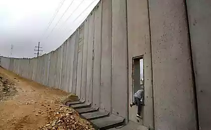
The border of Spain in Morocco
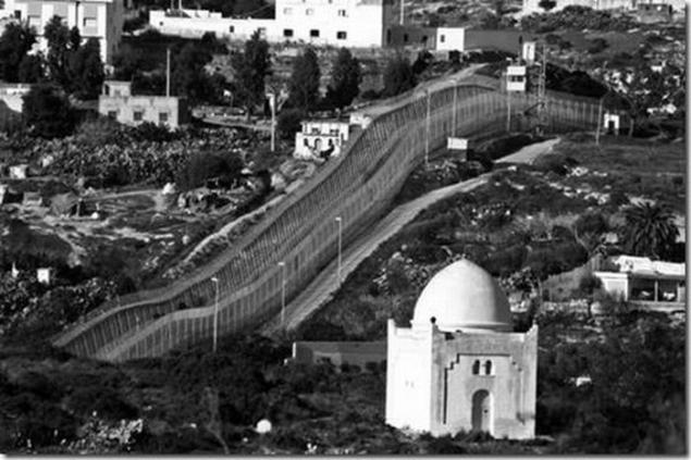
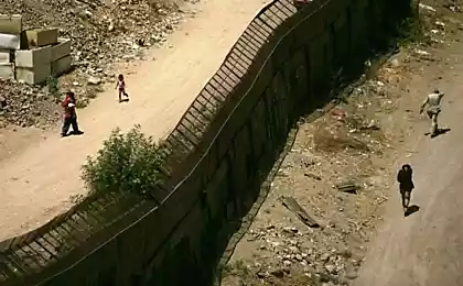
Small autonomous city of Ceuta belongs to Spain and is located on the north coast of North Africa. It is surrounded by Morocco on the one hand, and on the other the Strait of Gibraltar. Its area - 18, 5 square. km, population - 75 thousand. people. Morocco demands the return of Ceuta, together with the Spanish autonomous city of Melilla, and many other Mediterranean islands. This led Spain to set border 3 foot wall separating the city, topped with barbed wire.
The border between Belgium and the Netherlands among the tables in the cafe
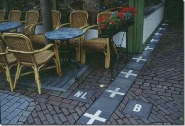
The border between Belgium and the Netherlands among the tables in the cafe & quot; / & gt;
Noteworthy is the state border between Baarle-Hertog and Baarle-Dutch municipality of Nassau, which passes through the neighborhoods and individual homes and shared Baarle-Hertog on 24 separate areas - the main settlement, 20 exclave surrounded by the territory of the Netherlands and the three sites adjacent to the Belgian territory. Seven Dutch exclaves are inside Belgian territory (within the main settlements and the largest enclave). A situation where individual houses are separated by a state border, arose when Dutch laws restaurants had closed early. Then the hosts began to place their restaurant on the border during the "closed" moving the customer to the tables on the Belgian side.
Bir Tawil
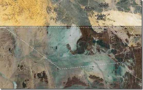
Bir Tawil - a territory with a total area of 2060 square kilometers, bordering Egypt to the north, and from the west, south and east Sudan. Both countries give up their claims to the Bir Tawil, so it is a "no man's land." Under the agreement, the border between the 1899 Egypt and Sudan took place on the 22th parallel. However, in 1902, Britain launched a new "administrative border", whereby Halaibsky triangle was placed under the control of the administration of the Sudan. At the same time Bir Tawil was placed under the control of Egypt, since its territory was used as pasture tribe living in Egyptian territory. After both countries gained independence, Halaibsky triangle remained under the control of the Sudan, and Bir Tawil - under Egyptian control. In 1958, Egypt demanded the return of the Sudan to the border in 1899 and the transfer of Halaibskogo triangle in exchange waived his right to Bir Tawil (which has a much lower value). Sudan has not agreed to give up a triangle and still recognize the border in 1902. So there is a unique situation - both countries bordering the Bir Tawil, do not consider it their territory. The permanent population in the area is not.
Mount Everest
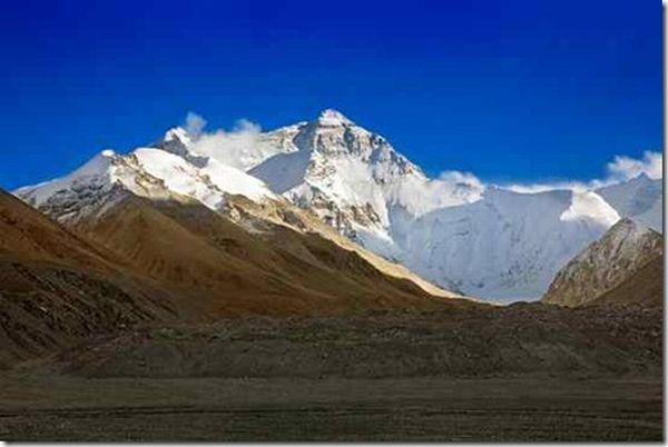
Surprised that this list makes the mountain. Of course, we all know that it is the highest mountain in the world, but not everyone knows that the border of Nepal and China goes right through the middle of the mountains, including the highest peak. Thus, it is the highest border area.
DC
The District of Columbia was originally a large territory, carved out of Maryland and Virginia. Because of its size, shape and location, near the border have unusual features. When the territory was originally delineated around large stones placed at the same distance from each other to mark the border. It turned out exactly one hundred stones on each side. To date, a few stones missing, but most survived. And as there are streets in which one side of the state, and the other has another.
Derby Line, Vermont
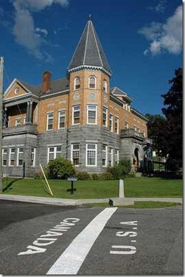
The city is located on the border between the United States and Canada. The border runs right through the city, even through some buildings and houses. It happens that the family prepares a meal in one country and eat the other. The city is also famous Free Library and Opera House Haskell. They were intentionally based on the border for joint cultural development. Opera stage is in Canada, but the entrance to the opera, and most places are located in the United States. Since the building varies between countries, it has two postal addresses, one for US and one for Canada.
District Cooch-Behar
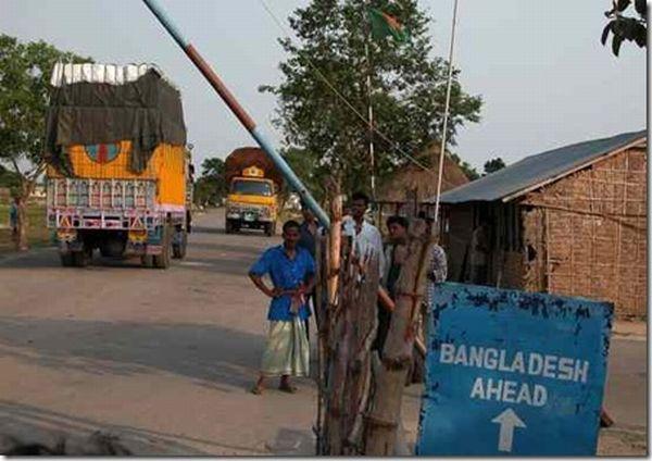
The district Cooch-Behar borders have somewhat similar border Baarle-Nassau / Baarle-Hertog. There are many areas under the jurisdiction of Bangladesh, who are in India, and vice versa. Additional feature - the Indian region Belepera Hegreberi. How enclave (exclave - non-sovereign region, separated from the main territory of the country and surrounded by more than one State), this area is surrounded by the Bangladesh territory. In turn, Belepera Hegreberi surrounds another Bangladeshi territory, which in turn is surrounded by another Indian territory, Dahala Khagrabari, making it the only place in the world, which includes the exclave exclave, which itself contains another enclave.
Korean demilitarized zone
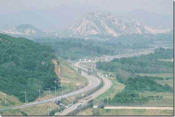
Korean DMZ - a strip of land 258 km long and 4 km wide, divides North and South Korea. This is the most militarized border in the world. Since the area is protected, and few people in there, it led to the emergence of a natural nature reserve. Many endangered species have chosen the DMZ residence. After the fall of the Berlin Wall, the demilitarized zone is considered the last relic of the Cold War era. The artificial division of the peninsula represents a sculptural group in the sector of the DMZ, which is designed for tourists. The sculpture depicts two families trying to connect the halves of the ball on the section where - map of the Korean peninsula. This is represented by a well-dressed South educated family, and the North - a poor family of ordinary people.
Misty River
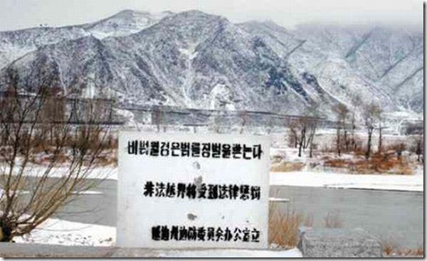
It flows in Northeast Asia. In most of the current border between China and North Korea, in the lower - between the DPRK and Russia. Thus, along the river, you can visit 3 countries. This walk may be unsafe, as it is a favorite place for North Koreans to try to desert, and for this reason, the area is patrolled by soldiers.
Diomede Islands
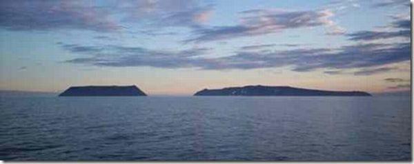
This is a pair of islands in the Bering Strait at a distance of about 35 km from Alaska and Chukotka. East Island (about 5 sq km), Little Diomede Island (Little Diomede) belongs to the United States. West Island - Ratmanova Island (Big Diomede), has an area of about 10 square kilometers and is owned by Russia. The distance between the islands of 4,160 m and between the state border of Russia and the US and the Date Line. Thus, when the residents of Little Diomede to look through the strait on Big Diomede, they do not just look at other countries, they "learn tomorrow." For example, when the US 9:00 Saturday on Little Diomede, in Russia 6:00 Sunday to Big Diomede. On the American island is Diomede village, home to 170 local residents - the Inuit. They opened a school and a shop and post office in good weather is delivered by helicopter. In the Russian island was only a military unit.
via liveinternet.ru
boundaries of conventional and not always noticeable. There is, perhaps, a sign of greeting in a particular place.
However, in the world there are unusual and remarkable borders,
which will be discussed today.
The border of Spain in Morocco

Small autonomous city of Ceuta belongs to Spain and is located on the north coast of North Africa. It is surrounded by Morocco on the one hand, and on the other the Strait of Gibraltar. Its area - 18, 5 square. km, population - 75 thousand. people. Morocco demands the return of Ceuta, together with the Spanish autonomous city of Melilla, and many other Mediterranean islands. This led Spain to set border 3 foot wall separating the city, topped with barbed wire.
The border between Belgium and the Netherlands among the tables in the cafe

The border between Belgium and the Netherlands among the tables in the cafe & quot; / & gt;
Noteworthy is the state border between Baarle-Hertog and Baarle-Dutch municipality of Nassau, which passes through the neighborhoods and individual homes and shared Baarle-Hertog on 24 separate areas - the main settlement, 20 exclave surrounded by the territory of the Netherlands and the three sites adjacent to the Belgian territory. Seven Dutch exclaves are inside Belgian territory (within the main settlements and the largest enclave). A situation where individual houses are separated by a state border, arose when Dutch laws restaurants had closed early. Then the hosts began to place their restaurant on the border during the "closed" moving the customer to the tables on the Belgian side.
Bir Tawil

Bir Tawil - a territory with a total area of 2060 square kilometers, bordering Egypt to the north, and from the west, south and east Sudan. Both countries give up their claims to the Bir Tawil, so it is a "no man's land." Under the agreement, the border between the 1899 Egypt and Sudan took place on the 22th parallel. However, in 1902, Britain launched a new "administrative border", whereby Halaibsky triangle was placed under the control of the administration of the Sudan. At the same time Bir Tawil was placed under the control of Egypt, since its territory was used as pasture tribe living in Egyptian territory. After both countries gained independence, Halaibsky triangle remained under the control of the Sudan, and Bir Tawil - under Egyptian control. In 1958, Egypt demanded the return of the Sudan to the border in 1899 and the transfer of Halaibskogo triangle in exchange waived his right to Bir Tawil (which has a much lower value). Sudan has not agreed to give up a triangle and still recognize the border in 1902. So there is a unique situation - both countries bordering the Bir Tawil, do not consider it their territory. The permanent population in the area is not.
Mount Everest

Surprised that this list makes the mountain. Of course, we all know that it is the highest mountain in the world, but not everyone knows that the border of Nepal and China goes right through the middle of the mountains, including the highest peak. Thus, it is the highest border area.
DC

The District of Columbia was originally a large territory, carved out of Maryland and Virginia. Because of its size, shape and location, near the border have unusual features. When the territory was originally delineated around large stones placed at the same distance from each other to mark the border. It turned out exactly one hundred stones on each side. To date, a few stones missing, but most survived. And as there are streets in which one side of the state, and the other has another.
Derby Line, Vermont

The city is located on the border between the United States and Canada. The border runs right through the city, even through some buildings and houses. It happens that the family prepares a meal in one country and eat the other. The city is also famous Free Library and Opera House Haskell. They were intentionally based on the border for joint cultural development. Opera stage is in Canada, but the entrance to the opera, and most places are located in the United States. Since the building varies between countries, it has two postal addresses, one for US and one for Canada.
District Cooch-Behar

The district Cooch-Behar borders have somewhat similar border Baarle-Nassau / Baarle-Hertog. There are many areas under the jurisdiction of Bangladesh, who are in India, and vice versa. Additional feature - the Indian region Belepera Hegreberi. How enclave (exclave - non-sovereign region, separated from the main territory of the country and surrounded by more than one State), this area is surrounded by the Bangladesh territory. In turn, Belepera Hegreberi surrounds another Bangladeshi territory, which in turn is surrounded by another Indian territory, Dahala Khagrabari, making it the only place in the world, which includes the exclave exclave, which itself contains another enclave.
Korean demilitarized zone

Korean DMZ - a strip of land 258 km long and 4 km wide, divides North and South Korea. This is the most militarized border in the world. Since the area is protected, and few people in there, it led to the emergence of a natural nature reserve. Many endangered species have chosen the DMZ residence. After the fall of the Berlin Wall, the demilitarized zone is considered the last relic of the Cold War era. The artificial division of the peninsula represents a sculptural group in the sector of the DMZ, which is designed for tourists. The sculpture depicts two families trying to connect the halves of the ball on the section where - map of the Korean peninsula. This is represented by a well-dressed South educated family, and the North - a poor family of ordinary people.
Misty River

It flows in Northeast Asia. In most of the current border between China and North Korea, in the lower - between the DPRK and Russia. Thus, along the river, you can visit 3 countries. This walk may be unsafe, as it is a favorite place for North Koreans to try to desert, and for this reason, the area is patrolled by soldiers.
Diomede Islands

This is a pair of islands in the Bering Strait at a distance of about 35 km from Alaska and Chukotka. East Island (about 5 sq km), Little Diomede Island (Little Diomede) belongs to the United States. West Island - Ratmanova Island (Big Diomede), has an area of about 10 square kilometers and is owned by Russia. The distance between the islands of 4,160 m and between the state border of Russia and the US and the Date Line. Thus, when the residents of Little Diomede to look through the strait on Big Diomede, they do not just look at other countries, they "learn tomorrow." For example, when the US 9:00 Saturday on Little Diomede, in Russia 6:00 Sunday to Big Diomede. On the American island is Diomede village, home to 170 local residents - the Inuit. They opened a school and a shop and post office in good weather is delivered by helicopter. In the Russian island was only a military unit.
via liveinternet.ru