524
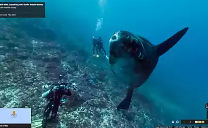
Scientists and Google have taken a panoramic shot of the Coral sea
Google is in collaboration with scientists from the University of Queensland and insurance firm the Catlin Group, said that starting a new project. Using panoramic photography, the partners plan to create something like an underwater version of the service Street View (panorama, streets) for the Great Barrier reef.
Says the chief scientist of the Catlin Seaview Survey project, Professor S Hugh-Guldberg, users will be able to see everything that happens under the surface of our oceans".
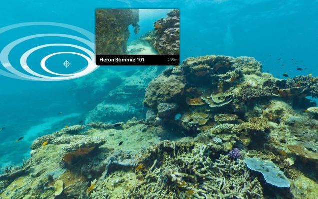
According to New Scientist, today researchers have managed to make several 360-degree underwater panoramas of the sample. Research is conducted at 20 stations of the reef. Photos and videos will be posted on the Internet on the progress of the work.
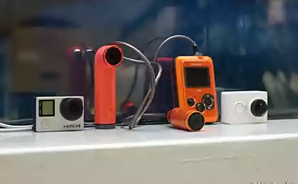
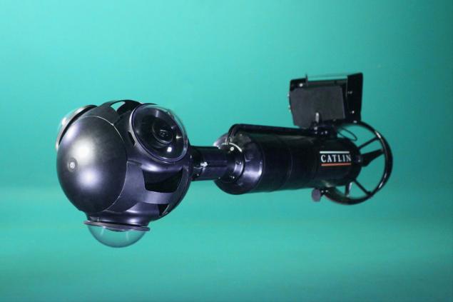
Underwater photography is specially produced for the project Catlin Seaview Survey the SVII camera, which is controlled by the diver is moving at a speed of about 4 km/h and makes panoramic images every 4-6 seconds.
SVII can operate on the depth up to hundred meters in poor lighting conditions, and copes well with the characteristic distortion of the underwater world. It consists of four SLR cameras with lenses, made on the principle of a fisheye lens aimed in different directions. It was also planned to panoramic video, however, scientists have not been able to find a suitable camera.
The researchers plan to capture about 50 thousand panoramas to be included in such services as Google Earth, Google Maps and YouTube.
"Usually the research only interested in scientists, the public was not attracted. Our project is quite different, say the authors. – It will allow people to remotely explore the underwater world via any device connected to the Internet will allow you to choose the place for diving and to take a virtual dive".
Source: /users/448
Says the chief scientist of the Catlin Seaview Survey project, Professor S Hugh-Guldberg, users will be able to see everything that happens under the surface of our oceans".

According to New Scientist, today researchers have managed to make several 360-degree underwater panoramas of the sample. Research is conducted at 20 stations of the reef. Photos and videos will be posted on the Internet on the progress of the work.
Underwater photography is specially produced for the project Catlin Seaview Survey the SVII camera, which is controlled by the diver is moving at a speed of about 4 km/h and makes panoramic images every 4-6 seconds.
SVII can operate on the depth up to hundred meters in poor lighting conditions, and copes well with the characteristic distortion of the underwater world. It consists of four SLR cameras with lenses, made on the principle of a fisheye lens aimed in different directions. It was also planned to panoramic video, however, scientists have not been able to find a suitable camera.

The researchers plan to capture about 50 thousand panoramas to be included in such services as Google Earth, Google Maps and YouTube.
"Usually the research only interested in scientists, the public was not attracted. Our project is quite different, say the authors. – It will allow people to remotely explore the underwater world via any device connected to the Internet will allow you to choose the place for diving and to take a virtual dive".
Source: /users/448