813
Drones can replace surveyor on construction site
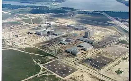
Company Identified Technologies showed showed its automated complex consisting of quadrocopters and robot base platform for its service. The complex is intended by the creators can be used for such work at the construction site, which usually requires the involvement of an engineer-surveyor: measuring distances, areas, volumes calculation of excavation and several other functions. The authors promise subsantimetrovuyu accuracy.
The principle of operation of the complex is primarily based on the work quadrocopters that flies over the building site (or any other topographical) and performs photogrammetric shooting. Creating models and processing in real time: the engineer comes to a special website and see the results of the shooting without copying its files and process them. All data is stored in file formats compatible with popular GIS software.
Usually the calculation of the volume of excavation requires the engineer surveyor enough time. It is necessary to have a special layout of the pit or trench to determine elevations characteristic points, perform calculations. As the authors say the development, the solution to this problem will require an engineer minimal action - using the mouse to specify the area on the building plan and wait for the completion of shooting.

Calculating volume of excavation, photo Identified Technologies sup> i>
The complex also can be used to map the area, as well as monitoring the status of industrial plants, when their regular geodetic survey will be impossible. The price set yet unknown.
Source: geektimes.ru/post/249718/