674
The fortress-settlement Arkaim
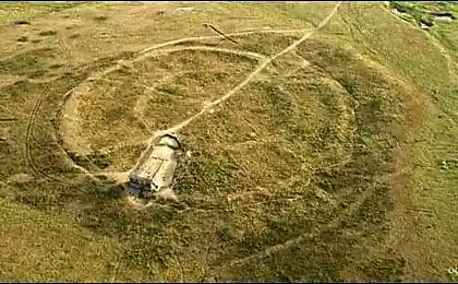
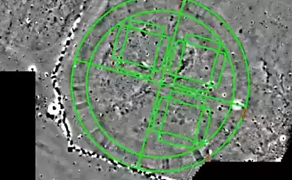
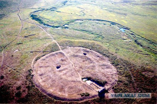
Not as well known as Stonehenge, but no less unique and even more difficult fortress-settlement arch was opened in 1987 near the city of Chelyabinsk. Careful study of this annular structures IV - III millennium BC archaeologists and astronomers found that it prigorizontnaya Observatory limit accuracy class having age of 4800 years. Modern astronomers were amazed by the Multidisciplinary, complexity and accuracy of implementation of a "project", especially since no traces of earlier and simpler structures were found.
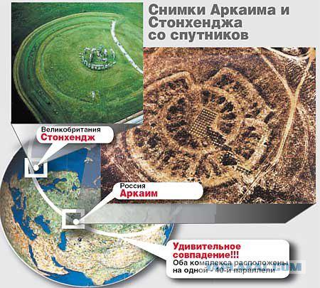
More than remarkable is that even though these objects are isolated in space, they perform the same functions and are built on similar principles. Studies have established that created Arkaim civilization was developed metallurgical and blacksmithing (found furnaces and forging tools); rudiments of writing and urban way of life and monumental architecture. In particular, the nine-discovered pyramid with a base of 72m and a height of about 10 m, topped with a dome and the "tree of life».
From the set of the revealed laws it would be worth noting the use of the inner circle of the 27 radial wall construction rules of the golden section of the circle and its parts and dvenadtsatichastnogo zodiacal division. The inner circle was dedicated to the Sun and the outer - the Moon. The angle of inclination of the lunar orbit to the ecliptic plane (5 ° 09 ') is defined very precisely. When the device ring wall of the inner circle was used by a circle of radius 52, 65 Arkaim measures of length (80, 0 cm.), Which corresponds to 52 ° 39 '- latitude Arkaima! Latitude Arkaima, by the way, is close to the latitude of the Altai barrow Arjan (52 ° 00 ') and Stonehenge (51 ° 17'), and perhaps this "band" on the surface of the Earth, as well as the 30th parallel, was something wonderful for Ancient astronomers and priests.
Found evidence of awareness of the phenomenon of precession of the South Urals the Earth's axis, expressed in the ratios of the inner ring. The period of this phenomenon is huge - 25,786 years old, but arkaimtsy display the appropriate parameters to quite correctly and accurately. The researchers note that the creation of an observatory of this kind need to know that the Earth is a sphere, and with the rest of the planets moving around the sun ... By the way, at the Arkaim ceramic ware discovered the sacred sign of the sun - the swastika. Surprises also that the city and burial structures in the plan is a combination of a circle and a square.
For more information:
ARKAIM (Arkijah) - archaeological complex, including a fortified settlement and surrounding shopping areas, burial, some unfortified Villages.
The name "Arch" perhaps from the Turkic (bash). "Arch" ("arka") - "ridge", "back", "foundation." Given the title, and the hill tracts. The complex is located in the Chelyabinsk region (on the territory. Ist. RB) on the river Big Karaganka and its left tributary of the river valley in the foothills Utyaganke the eastern slopes of the Ural (Repeyskih) Mountains.
The monument dates from the 2nd quarter of the 2nd millennium BC (17-16 centuries BC.).
Radiocarbon dates - 3.600-3.900 years ago.
The complex is investigated since 1987 archaeological expedition under the leadership of the University of Chelyabinsk GB Zdanovich.
Fortified settlement Arkaim
Total area - 20,000 square meters. m.
The area of archaeological excavations (in 1993) - 8,055 sq. m.
Geophysical studies were conducted on an area of 7.600 square meters. m.
The settlement is recorded as two inscribed into each other, rings embankments with 4 passes outer moat, two laps housing depressions and the central square.
Shafts are remnants of defensive walls, built of earth, adobe blocks and wood.
The diameter of the inner wall (the wall of the citadel) - 85 m.
Wall thickness - 3-4 meters, and the height is greater than the outside. The wall was strictly vertical and outside - for a log wall - plastered with clay.
The diameter of the outer walls - 143-145 m.
It was built from the log stands hammered soil with the addition of lime, and the outside is lined with adobe blocks, starting from the bottom of the pit, and up to the upper edge - a total of 5-6 meters.
The height of the ground in ancient times was not less than 3-3, 5 m.
By the fortifications are radial walls that broke the outer ring of houses 5 or 7 sectors.
Dwellings in trapezoidal plan, land at 110-180 square meters. m., built of log frames and ground units.
Adjacent homes had common long wall.
Approximately 1/3 of the dwelling was given by general use. Here are a well, cellar, fireplace, combined with the metallurgical furnace.
Dwellings Citadel converted outputs to the central square. The area had a rectangular shape (25h27 m) and was intended, obviously, for the ritual.
Dwellings outer ring facing the outputs to the circular street that links all entrances to the village. and all the houses to the main square.
Under the flooring found a circular street with the moat stormwater manhole.
On settlement archaeological digs studied 29 homes: 17 external and 12 in the inner circle.
Geophysical methods found that only in the outer circle were 35 dwellings in the inner - 25 (19 - 6 large and small, built between the main dwellings in the growth of the population).
9000 collected fragments of ceramics, bone and stone tools made of metal (knives interception, sickles, Struga, awls, ornaments), a variety of subjects related to metallurgy and metalworking molds, slag, nozzles, hammers and anvils. Saturation of the cultural layer material remains small.
Arkaima households was based on pastoral animal husbandry with elements of agriculture.
96 percent paleozoological findings constitute bone pets: 60-65% - cattle, 20-25% - of sheep and goats, 15% - horses.
On the territory of Arkaim valley in the radius of 5-6 km from the fortified center registered at least 5 multi-layer Bronze Age settlements with remnants of the layers 17-16 centuries. BC. Perhaps it was the small size settlements without fortification. It is possible that with the strengthening of the centers were connected and more remote unfortified settlement.
Construction geodesically strictly oriented to the cardinal. Up to the minute of arc on the horizon exhibited signs marking the latitude (East-West) and meridional (North-South) line passing through the geometric center of the structure. The geometric center of the outer and inner circles lie on a latitude line and spaced apart by 4 meters 20 centimeters, wherein the outer circle is shifted relative to the inner east.
According to the accuracy of orientation competition Arkaim throughout the ancient world can make only a few pyramids of Egypt, but they are under the age of two hundred years.
There Arkaim measure of length - 80, 0 cm.
The outer circle is constructed using a circle with a radius of 90 Arkaim measures.
The distance between the centers of the circles of 5, 25 Arkaim measure that is close to the angle of inclination of the lunar orbit - 5 9 degrees plus or minus 10 minutes.
The average radius of the inner circle - around 24 measures in the ecliptic coordinate system shows the trajectory of the pole of the world, described them around the pole of the ecliptic over a period of 25,920 years.
Burial Arch
Burial Triomphe is on the left bank of the river Big Karaganka in 1-1, 5 km north-east of the settlement of Arkaim.
5 mounds investigated.
The dominant position in the cemetery occupied by large, with a diameter of 17-19 m, grave fields, uniting pits 12-20.
The originality of funerary architecture define the deep - up to 3, 5 m - burial pit with large hollow burial chambers, terraces, a few wooden beams. On top of pits were closed individual ground bulk structures or false-vaulted domes of adobe blocks. Burial pits in single, double, group; inhumation on the side, in the low- or medium-crouched position.
Anthropological type of buried - protoevropeoidny.
Burials are accompanied by a rich inventory, especially in the central pits: bronze leaf-shaped knives, axes, adzes, chisels, awls, spear, spear, etc. Bronzes, arrowheads made of stone and bone, stone mace, accessories harness, decorations and so on .d.
The ceramic complexes dominated by acute rib-pots decorated with geometric designs.
Numerous remains of sacrificial animals (horses, cattle and sheep and goats, dog).
Also studied burial field, combining 7-8 burial pits with relatively poor grave goods.
Country City
The cultural complex Arkaim included in the group of fortified settlements in the Southern Urals, called "Country City».
It is located south of the river Uy, took mainly the watershed of the rivers Ural and Tobol.
"Country of cities" is made up of two dozen complexes.
The length of the occupied territory of 350-400 km in the direction north-south and 120-150 km - East-West.
The distance between both fortified settlements existed was 50-70 km.
Radius developed territory corresponded to 25-35 km (area of approx. 2,000 sq. Km.).
Cultural complex Arkaim (Sintashta) type with their hierarchy of settlements and cemeteries should be viewed as territorial entities with elements of early statehood, close to the "chiefdoms" or "chifdomu».
"Photography is probably Muldasheva" again on the line measured the globe!
Source: http: //
More than remarkable is that even though these objects are isolated in space, they perform the same functions and are built on similar principles. Studies have established that created Arkaim civilization was developed metallurgical and blacksmithing (found furnaces and forging tools); rudiments of writing and urban way of life and monumental architecture. In particular, the nine-discovered pyramid with a base of 72m and a height of about 10 m, topped with a dome and the "tree of life».
From the set of the revealed laws it would be worth noting the use of the inner circle of the 27 radial wall construction rules of the golden section of the circle and its parts and dvenadtsatichastnogo zodiacal division. The inner circle was dedicated to the Sun and the outer - the Moon. The angle of inclination of the lunar orbit to the ecliptic plane (5 ° 09 ') is defined very precisely. When the device ring wall of the inner circle was used by a circle of radius 52, 65 Arkaim measures of length (80, 0 cm.), Which corresponds to 52 ° 39 '- latitude Arkaima! Latitude Arkaima, by the way, is close to the latitude of the Altai barrow Arjan (52 ° 00 ') and Stonehenge (51 ° 17'), and perhaps this "band" on the surface of the Earth, as well as the 30th parallel, was something wonderful for Ancient astronomers and priests.
Found evidence of awareness of the phenomenon of precession of the South Urals the Earth's axis, expressed in the ratios of the inner ring. The period of this phenomenon is huge - 25,786 years old, but arkaimtsy display the appropriate parameters to quite correctly and accurately. The researchers note that the creation of an observatory of this kind need to know that the Earth is a sphere, and with the rest of the planets moving around the sun ... By the way, at the Arkaim ceramic ware discovered the sacred sign of the sun - the swastika. Surprises also that the city and burial structures in the plan is a combination of a circle and a square.

For more information:
ARKAIM (Arkijah) - archaeological complex, including a fortified settlement and surrounding shopping areas, burial, some unfortified Villages.
The name "Arch" perhaps from the Turkic (bash). "Arch" ("arka") - "ridge", "back", "foundation." Given the title, and the hill tracts. The complex is located in the Chelyabinsk region (on the territory. Ist. RB) on the river Big Karaganka and its left tributary of the river valley in the foothills Utyaganke the eastern slopes of the Ural (Repeyskih) Mountains.
The monument dates from the 2nd quarter of the 2nd millennium BC (17-16 centuries BC.).
Radiocarbon dates - 3.600-3.900 years ago.
The complex is investigated since 1987 archaeological expedition under the leadership of the University of Chelyabinsk GB Zdanovich.
Fortified settlement Arkaim
Total area - 20,000 square meters. m.
The area of archaeological excavations (in 1993) - 8,055 sq. m.
Geophysical studies were conducted on an area of 7.600 square meters. m.
The settlement is recorded as two inscribed into each other, rings embankments with 4 passes outer moat, two laps housing depressions and the central square.
Shafts are remnants of defensive walls, built of earth, adobe blocks and wood.
The diameter of the inner wall (the wall of the citadel) - 85 m.
Wall thickness - 3-4 meters, and the height is greater than the outside. The wall was strictly vertical and outside - for a log wall - plastered with clay.
The diameter of the outer walls - 143-145 m.
It was built from the log stands hammered soil with the addition of lime, and the outside is lined with adobe blocks, starting from the bottom of the pit, and up to the upper edge - a total of 5-6 meters.
The height of the ground in ancient times was not less than 3-3, 5 m.
By the fortifications are radial walls that broke the outer ring of houses 5 or 7 sectors.
Dwellings in trapezoidal plan, land at 110-180 square meters. m., built of log frames and ground units.
Adjacent homes had common long wall.
Approximately 1/3 of the dwelling was given by general use. Here are a well, cellar, fireplace, combined with the metallurgical furnace.
Dwellings Citadel converted outputs to the central square. The area had a rectangular shape (25h27 m) and was intended, obviously, for the ritual.
Dwellings outer ring facing the outputs to the circular street that links all entrances to the village. and all the houses to the main square.
Under the flooring found a circular street with the moat stormwater manhole.
On settlement archaeological digs studied 29 homes: 17 external and 12 in the inner circle.
Geophysical methods found that only in the outer circle were 35 dwellings in the inner - 25 (19 - 6 large and small, built between the main dwellings in the growth of the population).
9000 collected fragments of ceramics, bone and stone tools made of metal (knives interception, sickles, Struga, awls, ornaments), a variety of subjects related to metallurgy and metalworking molds, slag, nozzles, hammers and anvils. Saturation of the cultural layer material remains small.
Arkaima households was based on pastoral animal husbandry with elements of agriculture.
96 percent paleozoological findings constitute bone pets: 60-65% - cattle, 20-25% - of sheep and goats, 15% - horses.
On the territory of Arkaim valley in the radius of 5-6 km from the fortified center registered at least 5 multi-layer Bronze Age settlements with remnants of the layers 17-16 centuries. BC. Perhaps it was the small size settlements without fortification. It is possible that with the strengthening of the centers were connected and more remote unfortified settlement.
Construction geodesically strictly oriented to the cardinal. Up to the minute of arc on the horizon exhibited signs marking the latitude (East-West) and meridional (North-South) line passing through the geometric center of the structure. The geometric center of the outer and inner circles lie on a latitude line and spaced apart by 4 meters 20 centimeters, wherein the outer circle is shifted relative to the inner east.
According to the accuracy of orientation competition Arkaim throughout the ancient world can make only a few pyramids of Egypt, but they are under the age of two hundred years.
There Arkaim measure of length - 80, 0 cm.
The outer circle is constructed using a circle with a radius of 90 Arkaim measures.
The distance between the centers of the circles of 5, 25 Arkaim measure that is close to the angle of inclination of the lunar orbit - 5 9 degrees plus or minus 10 minutes.
The average radius of the inner circle - around 24 measures in the ecliptic coordinate system shows the trajectory of the pole of the world, described them around the pole of the ecliptic over a period of 25,920 years.
Burial Arch
Burial Triomphe is on the left bank of the river Big Karaganka in 1-1, 5 km north-east of the settlement of Arkaim.
5 mounds investigated.
The dominant position in the cemetery occupied by large, with a diameter of 17-19 m, grave fields, uniting pits 12-20.
The originality of funerary architecture define the deep - up to 3, 5 m - burial pit with large hollow burial chambers, terraces, a few wooden beams. On top of pits were closed individual ground bulk structures or false-vaulted domes of adobe blocks. Burial pits in single, double, group; inhumation on the side, in the low- or medium-crouched position.
Anthropological type of buried - protoevropeoidny.
Burials are accompanied by a rich inventory, especially in the central pits: bronze leaf-shaped knives, axes, adzes, chisels, awls, spear, spear, etc. Bronzes, arrowheads made of stone and bone, stone mace, accessories harness, decorations and so on .d.
The ceramic complexes dominated by acute rib-pots decorated with geometric designs.
Numerous remains of sacrificial animals (horses, cattle and sheep and goats, dog).
Also studied burial field, combining 7-8 burial pits with relatively poor grave goods.
Country City
The cultural complex Arkaim included in the group of fortified settlements in the Southern Urals, called "Country City».
It is located south of the river Uy, took mainly the watershed of the rivers Ural and Tobol.
"Country of cities" is made up of two dozen complexes.
The length of the occupied territory of 350-400 km in the direction north-south and 120-150 km - East-West.
The distance between both fortified settlements existed was 50-70 km.
Radius developed territory corresponded to 25-35 km (area of approx. 2,000 sq. Km.).
Cultural complex Arkaim (Sintashta) type with their hierarchy of settlements and cemeteries should be viewed as territorial entities with elements of early statehood, close to the "chiefdoms" or "chifdomu».
"Photography is probably Muldasheva" again on the line measured the globe!

Source: http: //