781
GLONASS / GPS Navigator "Grotto-M"
Writes Denis Mokrushin:
Last summer I was in his blog raised the topic of comparing Russian and American navigators, used by the military authorities of the two countries. After a while I went developers Russian navigator and offered to show your child and talk about it more.
11 ph + video
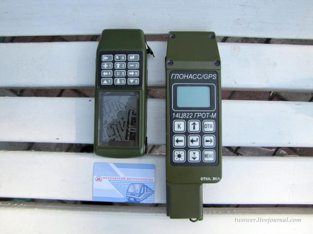
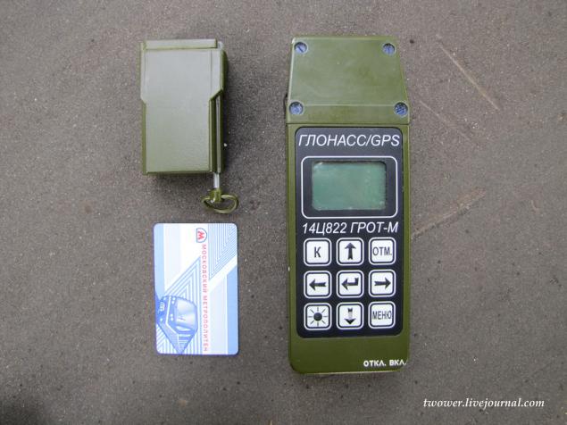
In the photo are two GLONASS / GPS navigator of "Research Institute of Space Device Engineering": Right - the equipment of the previous generation 14TS822 "Grotto-M" on the left - a new sample, which has the same name as the previous one - "Grotto-M", but is deep modernization younger brother.
The first "Grotto", released in 2003, is in service with the Russian army, as well as several countries in Africa and Latin America (Navigator menu has English, French and Spanish versions) and made a circulation of 10 thousand copies. Our armed forces used mainly commanders of artillery units, exploration, mining arrows and special units. According to the state it is necessary to have in the infantry battalion and company tactical groups operating in isolation from the main forces.
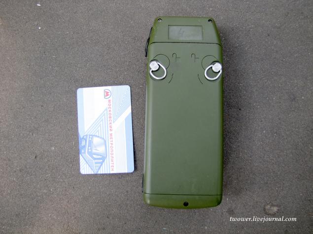
The body is made from a single navigation bar of aluminum milling method, which results in a high strength of the product, but also significantly increase the weight of it (the weight of the device was 800 grams). Since the instrument was originally intended only to determine the coordinates and targets in the artillery, he received a small screen and supports the display of maps. For convenience, in the bitter cold when his gloved hands, the navigator equipped with large buttons that are very popular with end-users - the military
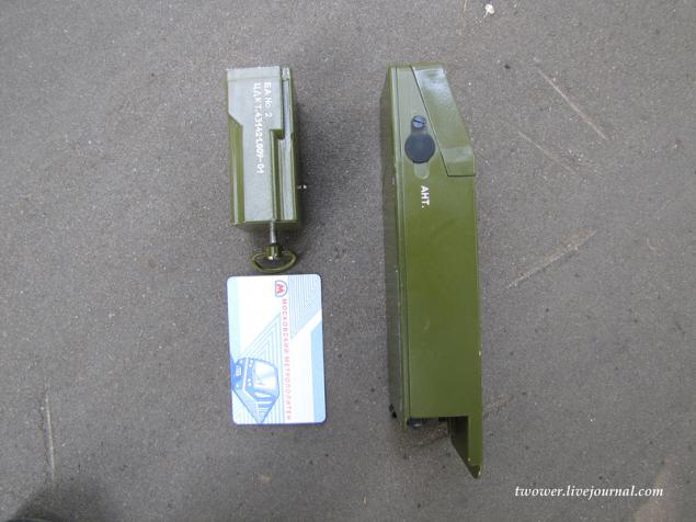
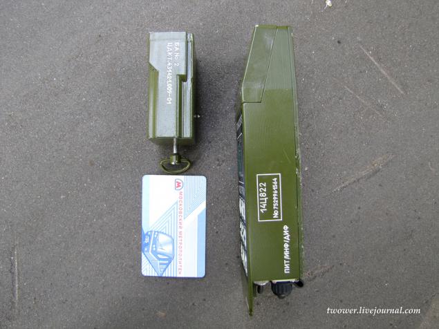
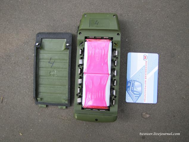
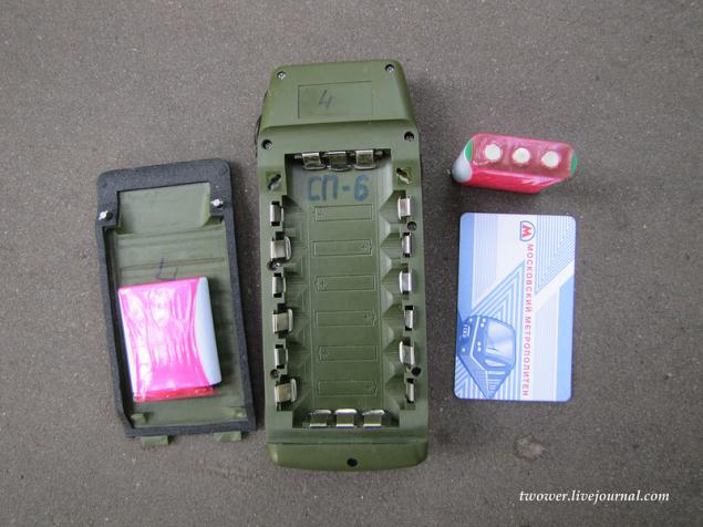
Included were two batteries, which due to design features elongated body up to 25 cm
04
05
06
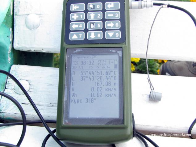
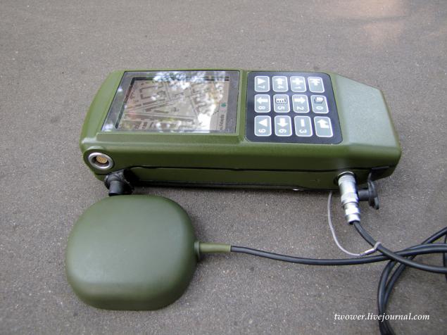
As time goes on and technology go ahead, now on its own initiative was held deep modernization of the Navigator, which actually led to the creation of an entirely new device, but under the same name - "Grotto-M." The product has received a new 32-bit processor ARM, large color display with a resolution of 320x240. The buttons have been moved to the top of the browser, as it is in this position the device is most convenient in the hand and pressing the most comfortable.
From touchscreen refused because in cold climates and hands with gloves it is simply useless.
The case became a plastic, power supplies found another location.
Uses a lithium-polymer battery 2500 mAh of French production, as domestic battery manufacturers explained that the orders are very busy and will not be able to deliver their products earlier than a few years
The navigator can operate on a single battery pack, but then decreases during its operation. Navigator with an air temperature above zero degrees works about 18 hours continuously at a temperature as low as possible, which is designed (-30 ° C), - at least 12 hours.
In addition to battery modules and the product can be operated by conventional AA batteries AA
Navigator can withstand submersion at a depth of 1 meter during the day and can then work.
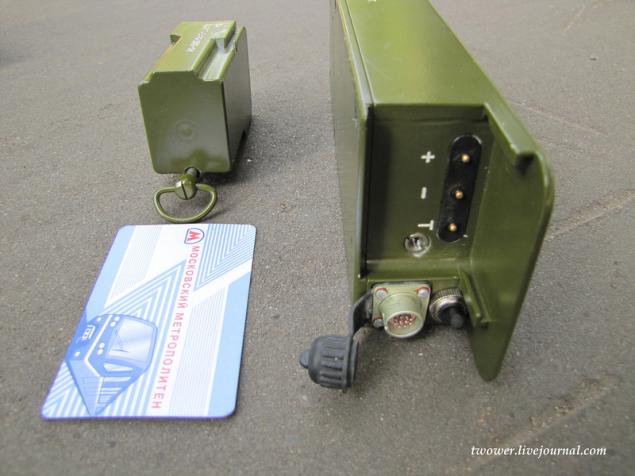
"Grotto" can be connected to the network with low voltage (10 to 30 volts), which allows you to charge it from an onboard network of cars and armored vehicles. Charge the battery packs is possible both in the device itself, or in a separate charger.
At the time of communication with the developers (August 2011) The power consumption navigator made on 130 nm process, was 1.05-1.1 W (at the peak of the work up to 1.2 watts), but is now on the website updated information, it is no more than 1 watt, which means, that took the expected transition to 110-nm process technology.
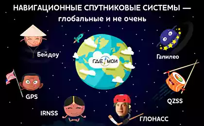
It should be noted that the power consumption of devices based on GLONASS will always be more similar devices based on GPS, as the domestic navigation system uses a wider range of frequencies. Wide channel harder to suppress electronic warfare, but the plus is exchanged for a higher power.
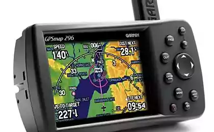
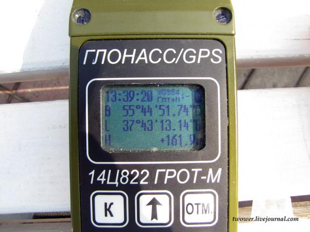
The navigator can operate simultaneously with the 32 satellites, which greatly improves the accuracy of positioning. She (accuracy) depends on many factors (number of satellites, terrain, etc.) and for the "Grotto" is 10 m (operating mode, when the interaction is only with satellites), which is comparable with those of the US military navigator DAGR. The differential mode is also implemented in the domestic browser, which allows using the base stations to increase the positioning accuracy of up to tens of centimeters.
"Grotto-M" with the external antenna navigation. The antenna has a magnet and can be used when driving a car
At the request of the customer installation slots for SD-card flash memory, but the military is not being asked about such a possibility. The inner memory of the device is 256 megabytes.
My favorite question of all the readers I was asked: "Whose production of electronic component navigator?". The chip entirely designed in the company, in addition to the processor core, which is purchased under license. Digital circuitry of the topology - all domestic, but the physical manufacturing - China and Taiwan. Mounting board again going with us. Displays also purchased abroad since Belarusian developers (alternative countries) offer models with high energy, weight and cost.
Navigator allows you to record the route and display it on a map background. Maps, routes can be poured into the device and shooting him through the interface USB (port for USB, RS-232 and RS-485 alone, the bundle includes a splitter). Included with the product is a software that allows the end user to match the browser with the operating systems based on Linux and Windows. It is assumed that, if desired, the user can install in the "Grotto" any cards from third-party developers, using a special converter that comes with the software.
Navigator service can solve the problem, which are necessary for the needs of artillery:
- Given the coordinates, distance and bearing the coordinates of the point you want to rake;
- On the set is defined by two pairs of distance and bearing between them;
- Coordinates of the two points and the angle between the coordinates of the third point;
- Measurement of the azimuth and the like
Possible conversion of latitude and longitude coordinates in the Gauss-Kruger and back.
Example of menu navigation
Source:
Last summer I was in his blog raised the topic of comparing Russian and American navigators, used by the military authorities of the two countries. After a while I went developers Russian navigator and offered to show your child and talk about it more.
11 ph + video
In the photo are two GLONASS / GPS navigator of "Research Institute of Space Device Engineering": Right - the equipment of the previous generation 14TS822 "Grotto-M" on the left - a new sample, which has the same name as the previous one - "Grotto-M", but is deep modernization younger brother.

The first "Grotto", released in 2003, is in service with the Russian army, as well as several countries in Africa and Latin America (Navigator menu has English, French and Spanish versions) and made a circulation of 10 thousand copies. Our armed forces used mainly commanders of artillery units, exploration, mining arrows and special units. According to the state it is necessary to have in the infantry battalion and company tactical groups operating in isolation from the main forces.
The body is made from a single navigation bar of aluminum milling method, which results in a high strength of the product, but also significantly increase the weight of it (the weight of the device was 800 grams). Since the instrument was originally intended only to determine the coordinates and targets in the artillery, he received a small screen and supports the display of maps. For convenience, in the bitter cold when his gloved hands, the navigator equipped with large buttons that are very popular with end-users - the military

Included were two batteries, which due to design features elongated body up to 25 cm

04

05

06

As time goes on and technology go ahead, now on its own initiative was held deep modernization of the Navigator, which actually led to the creation of an entirely new device, but under the same name - "Grotto-M." The product has received a new 32-bit processor ARM, large color display with a resolution of 320x240. The buttons have been moved to the top of the browser, as it is in this position the device is most convenient in the hand and pressing the most comfortable.

From touchscreen refused because in cold climates and hands with gloves it is simply useless.
The case became a plastic, power supplies found another location.

Uses a lithium-polymer battery 2500 mAh of French production, as domestic battery manufacturers explained that the orders are very busy and will not be able to deliver their products earlier than a few years

The navigator can operate on a single battery pack, but then decreases during its operation. Navigator with an air temperature above zero degrees works about 18 hours continuously at a temperature as low as possible, which is designed (-30 ° C), - at least 12 hours.
In addition to battery modules and the product can be operated by conventional AA batteries AA

Navigator can withstand submersion at a depth of 1 meter during the day and can then work.
"Grotto" can be connected to the network with low voltage (10 to 30 volts), which allows you to charge it from an onboard network of cars and armored vehicles. Charge the battery packs is possible both in the device itself, or in a separate charger.
At the time of communication with the developers (August 2011) The power consumption navigator made on 130 nm process, was 1.05-1.1 W (at the peak of the work up to 1.2 watts), but is now on the website updated information, it is no more than 1 watt, which means, that took the expected transition to 110-nm process technology.
It should be noted that the power consumption of devices based on GLONASS will always be more similar devices based on GPS, as the domestic navigation system uses a wider range of frequencies. Wide channel harder to suppress electronic warfare, but the plus is exchanged for a higher power.
The navigator can operate simultaneously with the 32 satellites, which greatly improves the accuracy of positioning. She (accuracy) depends on many factors (number of satellites, terrain, etc.) and for the "Grotto" is 10 m (operating mode, when the interaction is only with satellites), which is comparable with those of the US military navigator DAGR. The differential mode is also implemented in the domestic browser, which allows using the base stations to increase the positioning accuracy of up to tens of centimeters.
"Grotto-M" with the external antenna navigation. The antenna has a magnet and can be used when driving a car

At the request of the customer installation slots for SD-card flash memory, but the military is not being asked about such a possibility. The inner memory of the device is 256 megabytes.
My favorite question of all the readers I was asked: "Whose production of electronic component navigator?". The chip entirely designed in the company, in addition to the processor core, which is purchased under license. Digital circuitry of the topology - all domestic, but the physical manufacturing - China and Taiwan. Mounting board again going with us. Displays also purchased abroad since Belarusian developers (alternative countries) offer models with high energy, weight and cost.
Navigator allows you to record the route and display it on a map background. Maps, routes can be poured into the device and shooting him through the interface USB (port for USB, RS-232 and RS-485 alone, the bundle includes a splitter). Included with the product is a software that allows the end user to match the browser with the operating systems based on Linux and Windows. It is assumed that, if desired, the user can install in the "Grotto" any cards from third-party developers, using a special converter that comes with the software.
Navigator service can solve the problem, which are necessary for the needs of artillery:
- Given the coordinates, distance and bearing the coordinates of the point you want to rake;
- On the set is defined by two pairs of distance and bearing between them;
- Coordinates of the two points and the angle between the coordinates of the third point;
- Measurement of the azimuth and the like
Possible conversion of latitude and longitude coordinates in the Gauss-Kruger and back.
Example of menu navigation
Source: