595
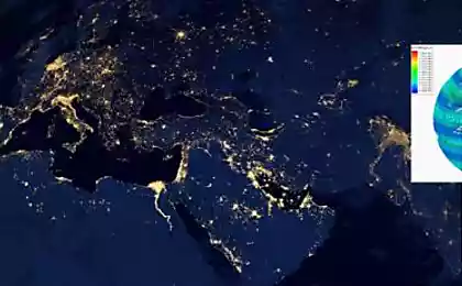
How many satellite systems revolves around the Earth
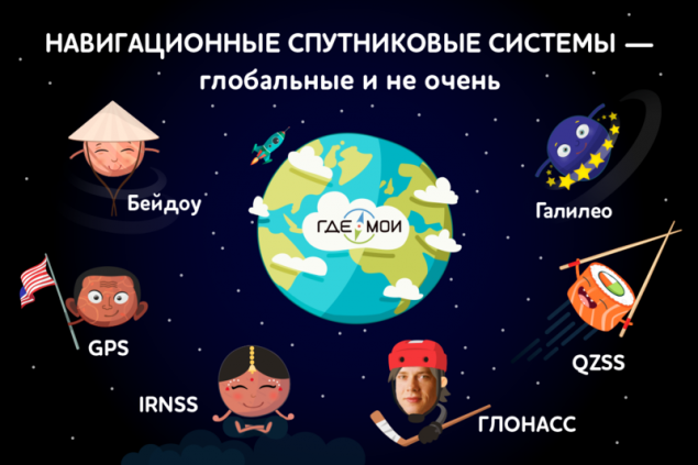
The majority of navigation satellite systems have emerged in response to the requests of the military and a long time was restricted to GPS and GLONASS. However, after it became clear that satellite data can be used effectively for peaceful purposes, the number of systems began to systematically increase.
We have examined the most significant of the existing NSS.
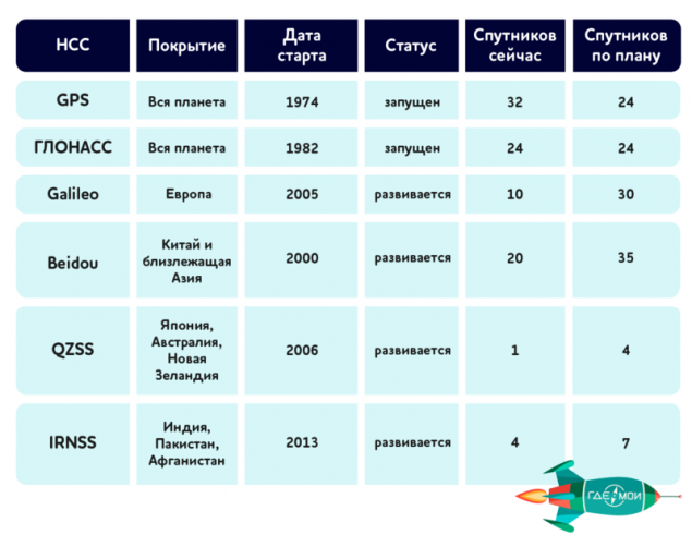
GPS global satellites beginning navigatiesystemen: 31
All satellites in orbit: 32
The average height from the Ground: 22180
The time of a full revolution around the Earth: 11 h 58 min
The American system appeared in 1974 and immediately made a splash with its efficiency. The US government even had to artificially lower the positioning accuracy, to keep benefits for its military. From self-created difficulties freed only in 2000 — after the decree of bill Clinton. The original architecture of the GPS meant using 24 satellites, but for greater reliability in orbit is just 32 slots, of which is constantly 31. Each satellite circles the Earth twice a day and is controlled from a military base Schriever radio frequency of 2000-4000 MHz. GPS has been and remains the undisputed leader among similar systems and find the NSS device without a chip support GPS is quite difficult — at least in the Western hemisphere. Despite his apparent success, the GPS is not in place. Already in 2017, will run the apparatus of the third generation, whose main feature is the ability to transmit civil signals: L2C, L5 and L1C. It is known that now the GPS signal is often lost among the city's skyscrapers. The launch of the new device solves this problem and is essential for integration with other systems, the signal L2C versatile and can work not only with GPS.
"The Russian rocket" Glasscastle satellites: 24
All satellites in orbit: 24
Average height: 19400 km
The time of a full revolution around the Earth: 11 h 15 min
On the impact of the cold war on technological progress in the United States and the Soviet Union heard everything. Therefore, the launch of the Soviet scientists own project in response to the advent of GPS — a step logical and expected. Despite the fact that work on the project GLONASS began in 1976, and the deployment of the program had spent $ 2.5 billion, the official launch of the system took place only in 1993. The nineties was for domestic science is not the most serene, funding has been reduced, because to catch up and overtake American brother we failed. However, the very occurrence of the second system has created necessary for the development of competition, has influenced the entire industry as a whole. In 2018 in space is scheduled to launch satellites GLONASS-K2, is also able to transmit signals in the ranges L1 and L2.
The European system GalileoДействующих satellites: 10
All satellites in orbit: 30 (planned)
Average altitude: 23222 km
The time of a full revolution around the Earth: 14 h 4 min.
The first non-global navigation systems was established by the European space Agency in the framework of the project TRANS-Eurasian network. It is funded by the governments of the EU (and acceding to China, Israel, South Korea), although many of them have their own space program. Now in orbit 10 satellites by 2020 the number is projected to triple. Only to launch the first two satellites of the European Union spent more than $ 1.5 billion. The first satellite was launched from Baikonur only in 2005 and only a month ago on orbit brought the 9 and 10 satellites.
It is obvious that in ten years it is impossible to create any competitive system, but Galileo already had first successes. For example, she managed to independently discover the location of the test aircraft during testing in 2013. At the same time Galileo "breathing in unison" with GPS. Its architecture allows to pick up signals from the American infrastructure and use it for your own navigation. Soon the Europeans are going to increase the accuracy of the system up to an incredible 10 inches during operation in a special mode.
The fastest growing system BeidouДействующих satellites: 20
All satellites in orbit: 35 (planned)
Average height: from 21500 to 36000 km
The time of a full revolution around the Earth: 12 h 38 min
This "yet" local navigation system, was launched in October 2000 in China and has become the most rapidly developing project in the industry. It is planned that by 2020, Beidou will receive 5 satellites in geo and 30 in renesemee Aribeth that will give her the right to be called a global navigation system. In contrast to Europe, aimed at cooperating with the Americans, the Chinese are actively on friendly terms with the Russian GLONASS. In may of this year, the presidents of the countries agreed on the mutual operation of the two systems.
Dmitry Rogozin, curator of the space program of the Russian Federation: "If, for example, GPS and Galileo appears here as a pair of navigation systems, covering the countries — members of NATO, we see the possibility of active cooperation the Russian-Chinese navigation systems. The more that China now ranks second in the world in possession of constellation."
Mobile Japanese QZSSДействующих satellites: 1
All satellites in orbit: 4 (planned)
Average height: from 32 000 to 42 164 km
The time of a full revolution around the Earth: 23 hours 56 min
An interesting project is the Japanese aerospace exploration Agency JAXA. It involves the launch into geosynchronous orbit of four satellites, designed to work in the Asian region. The first of them launched into space in 2010, and to complete the work planned by the end of 2017. The main feature of the project is focused on supporting mobile apps that for Japan, with its world's largest mobile market looks like a self-evident fact. The navigation system is focused primarily on improving the quality of mobile cartography, paid media, information about attractions for tourists and monitoring system of public transport.
The Indian couch potato IRNSSДействующих satellites: 4
All satellites in orbit: 7 (planned)
Average height: 36 000 km
The time of a full revolution around the Earth: 23 hours 56 min
Meeting the needs of more than a billion Indians — more than an ambitious task, therefore the Indian system in the near future for world domination does not apply. Four of the seven developed satellites already orbit the Earth to provide the people of the country all the benefits of navigation. Today is used in IRNSS terrestrial, aerial and marine navigation, accurate time service, liquidations of consequences of catastrophes, cartography and geodesy, logistics, vehicle tracking, tourism. And, of course, actively integrates with mobile phones — where without them now.
Instead of the end, again denote the main trends of satellite navigation:
Source: geektimes.ru/company/gdemoi/blog/264290/
We have examined the most significant of the existing NSS.

GPS global satellites beginning navigatiesystemen: 31
All satellites in orbit: 32
The average height from the Ground: 22180
The time of a full revolution around the Earth: 11 h 58 min
The American system appeared in 1974 and immediately made a splash with its efficiency. The US government even had to artificially lower the positioning accuracy, to keep benefits for its military. From self-created difficulties freed only in 2000 — after the decree of bill Clinton. The original architecture of the GPS meant using 24 satellites, but for greater reliability in orbit is just 32 slots, of which is constantly 31. Each satellite circles the Earth twice a day and is controlled from a military base Schriever radio frequency of 2000-4000 MHz. GPS has been and remains the undisputed leader among similar systems and find the NSS device without a chip support GPS is quite difficult — at least in the Western hemisphere. Despite his apparent success, the GPS is not in place. Already in 2017, will run the apparatus of the third generation, whose main feature is the ability to transmit civil signals: L2C, L5 and L1C. It is known that now the GPS signal is often lost among the city's skyscrapers. The launch of the new device solves this problem and is essential for integration with other systems, the signal L2C versatile and can work not only with GPS.
"The Russian rocket" Glasscastle satellites: 24
All satellites in orbit: 24
Average height: 19400 km
The time of a full revolution around the Earth: 11 h 15 min
On the impact of the cold war on technological progress in the United States and the Soviet Union heard everything. Therefore, the launch of the Soviet scientists own project in response to the advent of GPS — a step logical and expected. Despite the fact that work on the project GLONASS began in 1976, and the deployment of the program had spent $ 2.5 billion, the official launch of the system took place only in 1993. The nineties was for domestic science is not the most serene, funding has been reduced, because to catch up and overtake American brother we failed. However, the very occurrence of the second system has created necessary for the development of competition, has influenced the entire industry as a whole. In 2018 in space is scheduled to launch satellites GLONASS-K2, is also able to transmit signals in the ranges L1 and L2.
The European system GalileoДействующих satellites: 10
All satellites in orbit: 30 (planned)
Average altitude: 23222 km
The time of a full revolution around the Earth: 14 h 4 min.
The first non-global navigation systems was established by the European space Agency in the framework of the project TRANS-Eurasian network. It is funded by the governments of the EU (and acceding to China, Israel, South Korea), although many of them have their own space program. Now in orbit 10 satellites by 2020 the number is projected to triple. Only to launch the first two satellites of the European Union spent more than $ 1.5 billion. The first satellite was launched from Baikonur only in 2005 and only a month ago on orbit brought the 9 and 10 satellites.
It is obvious that in ten years it is impossible to create any competitive system, but Galileo already had first successes. For example, she managed to independently discover the location of the test aircraft during testing in 2013. At the same time Galileo "breathing in unison" with GPS. Its architecture allows to pick up signals from the American infrastructure and use it for your own navigation. Soon the Europeans are going to increase the accuracy of the system up to an incredible 10 inches during operation in a special mode.
The fastest growing system BeidouДействующих satellites: 20
All satellites in orbit: 35 (planned)
Average height: from 21500 to 36000 km
The time of a full revolution around the Earth: 12 h 38 min
This "yet" local navigation system, was launched in October 2000 in China and has become the most rapidly developing project in the industry. It is planned that by 2020, Beidou will receive 5 satellites in geo and 30 in renesemee Aribeth that will give her the right to be called a global navigation system. In contrast to Europe, aimed at cooperating with the Americans, the Chinese are actively on friendly terms with the Russian GLONASS. In may of this year, the presidents of the countries agreed on the mutual operation of the two systems.
Dmitry Rogozin, curator of the space program of the Russian Federation: "If, for example, GPS and Galileo appears here as a pair of navigation systems, covering the countries — members of NATO, we see the possibility of active cooperation the Russian-Chinese navigation systems. The more that China now ranks second in the world in possession of constellation."
Mobile Japanese QZSSДействующих satellites: 1
All satellites in orbit: 4 (planned)
Average height: from 32 000 to 42 164 km
The time of a full revolution around the Earth: 23 hours 56 min
An interesting project is the Japanese aerospace exploration Agency JAXA. It involves the launch into geosynchronous orbit of four satellites, designed to work in the Asian region. The first of them launched into space in 2010, and to complete the work planned by the end of 2017. The main feature of the project is focused on supporting mobile apps that for Japan, with its world's largest mobile market looks like a self-evident fact. The navigation system is focused primarily on improving the quality of mobile cartography, paid media, information about attractions for tourists and monitoring system of public transport.
The Indian couch potato IRNSSДействующих satellites: 4
All satellites in orbit: 7 (planned)
Average height: 36 000 km
The time of a full revolution around the Earth: 23 hours 56 min
Meeting the needs of more than a billion Indians — more than an ambitious task, therefore the Indian system in the near future for world domination does not apply. Four of the seven developed satellites already orbit the Earth to provide the people of the country all the benefits of navigation. Today is used in IRNSS terrestrial, aerial and marine navigation, accurate time service, liquidations of consequences of catastrophes, cartography and geodesy, logistics, vehicle tracking, tourism. And, of course, actively integrates with mobile phones — where without them now.

Instead of the end, again denote the main trends of satellite navigation:
- Versatility and integration. All systems to a greater or lesser extent, are moving toward using the signals of the same type and interaction with each other.
- Consolidation. The political and military background felt. If formally cold war long gone, in fact we see a clear division of space programs into "ours" and "theirs".
- A course on mobile technology. Focus on support for mobile applications — the most recent and most promising in our view the trend, the development of which will be watched closely in the future. And probably will not again will return to.published
Source: geektimes.ru/company/gdemoi/blog/264290/


5 entrepreneurs of the Russian Empire who created great companies
Mouth-watering cheesecake dessert! The secret ingredient!