539
What we did to the Earth?
Let's learn about how humanity has changed the planet Earth over the past half century. Clearly the fruits of our labours are shown on a special website NASA Images of change ("Images of change"), where taken at intervals of 5, 10, 50, 100 years of photography (primarily satellite) show, as was and as became. Melting glaciers, drying lakes, erosion of the coast, the desert approaching...
However, there were in the collection a place for the few achievements of mankind: from greening the Libyan desert with Gaddafi before the explosion in 1992, a Soviet dam, saved the unique Bay of Kara-Bogaz-Gol.
1. The Muir glacier (Alaska) in 1882 and 2005
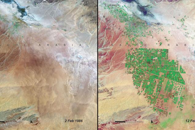
2. Greening of the desert
Wadi As-Sirhan, Northern Saudi Arabia: February 1986 — February 2004. A huge desert area, where before barely making ends meet, residents of the two towns (al-Isawiya and Tubarjal is the upper left corner of the picture), a couple of decades turned into a blooming garden. Many fields are irrigated using a circular irrigation. The water in Al-Sirhan is taken from an ancient aquifer. Economical and efficient use of resources helped to create from scratch an agricultural area, and with minimal environmental damage.
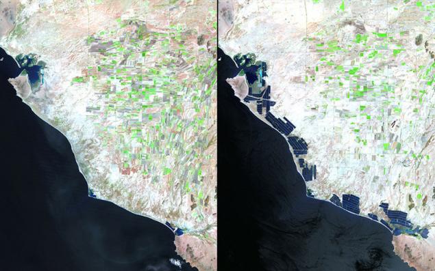
3. Economy and coastline
The West coast of Mexico, 1993 and 2011. Over the past decade in the state of Sonora, has opened dozens of shrimp farms. Although the new industry brought to the region a lot of money and jobs, its impact on the ecosystem is a concern to scientists.
4. Echo Of Chernobyl
The surroundings of Chernobyl, April 1986 — April 2011. In the picture of the Soviet era are visible the fields ready for planting (bright tones), dense forest (dark green) and the small rural settlement (blue, purple tones). 25 years later the field became grassland (bright green), forests destroyed (in their place, however, planted new trees — shades of green), and all the settlements abandoned.
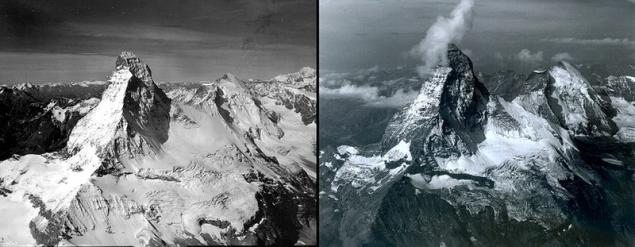
5. Melting ice in the Alps
Matterhorn peak (on the border between Switzerland and Italy) in August 1960 and 2005.
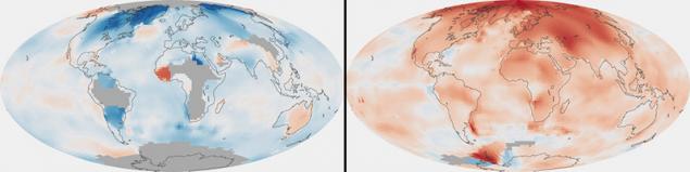
6. Global warming
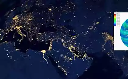
On these maps, NASA compares the average temperature in each region of the world in 1880-1889 and 2000-2009. Data obtained from research ships, satellites and 6300 meteorological stations. Since 1880 the average temperature at the Earth's surface increased by 0.7 degrees Celsius, two-thirds of the growth came in the last 40 years.
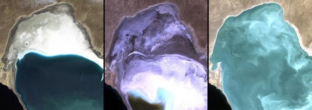
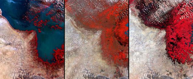
7. The Rescue Of Kara-Bogaz-Gol
Kara-Bogaz-Gol Bay-lagoon of the Caspian sea in the West of Turkmenistan in 1972, 1987 and 2010. The largest Deposit of salts. The construction in 1980 of the dam, separating the Kara-Bogaz-Gol of the Caspian sea, led to the fall of the water level and the formation of "salt pot", zagryaznenie the salt of the soil and causes lung disease. In 1992 the dam was blown up, and the ecosystem began to recover gradually.
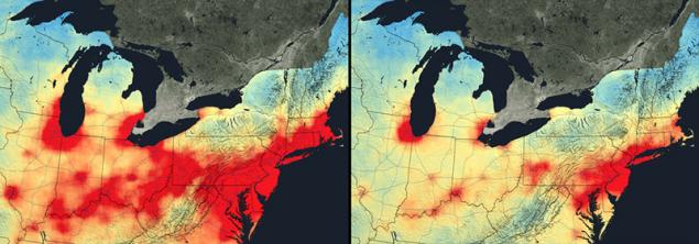
8. Air purification
Nitrogen dioxide (NO2) is a brownish gas, causing lung disease and is actively involved in the formation of other harmful substances. In the atmosphere it gets mainly from the burning of gasoline in automobile engines and coal in power plants. Due to new laws, technological progress and shifts in the U.S. economy, the concentration of NO2 in the atmosphere over the last decade is steadily declining (despite growing population and number of cars). The photo shows the Northern U.S. (the axis in Boston — Richmond), where once the highest levels of NO2.
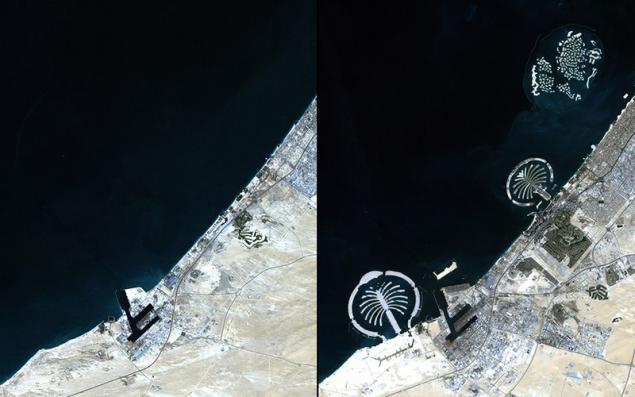
9. Artificial Islands
In 2001, in Dubai, located on the coast of the Persian Gulf, began work on the creation of artificial Islands. By 2012 there three Islands in the shape of palm trees: palm Jumeirah, palm Jebel Ali, palm Deira and the archipelagos of "the World" and "universe" of the smaller Islands.
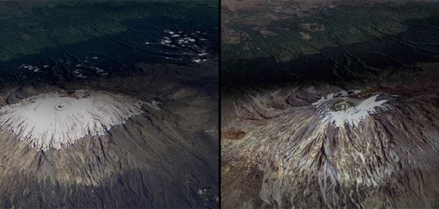
10. Farewell, the ice of Kilimanjaro!
Kilimanjaro — the highest mountain peak of Africa — in February 1993 and 2000. The picture shows how "shriveled" its ice cap.
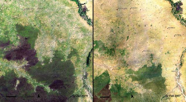
11. Deforestation
The forest of Baban Rafi (Niger, Maradi region) in 1976 and 2007. Located on the southern edge of the Sahel Baban Rafi is characterized by a vegetation of mixed type (characteristic of savannas and semi-deserts). The images show how the natural landscape (dark green tones) gives way to agriculture. In 40 years the population has grown by 40 times, and with it the need for land for fields. Remnants of forests are actively cut down for firewood.
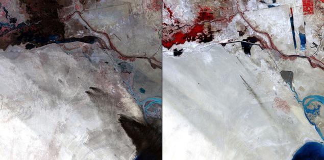
12. Saddam and the oil fields of Kuwait
The Sabria field in 1991 and 2011. Before retreating from Kuwait in 1991, Iraqi forces on the orders of Saddam Hussein set fire to about 700 oil wells. The combustion products were stained kilometers of soil in the black color (as seen in first picture). However, for 20 years, the ecosystem of the region recovered from the damage. The smoke in the second image — trace of the routine procedures of arson (with their help remove excess gases).
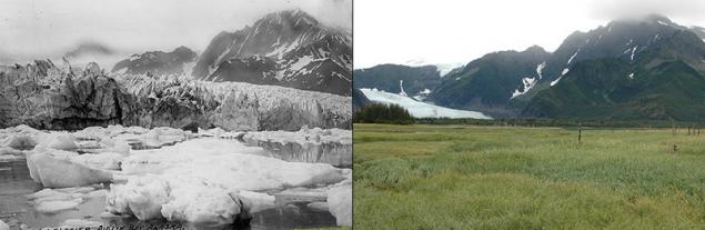
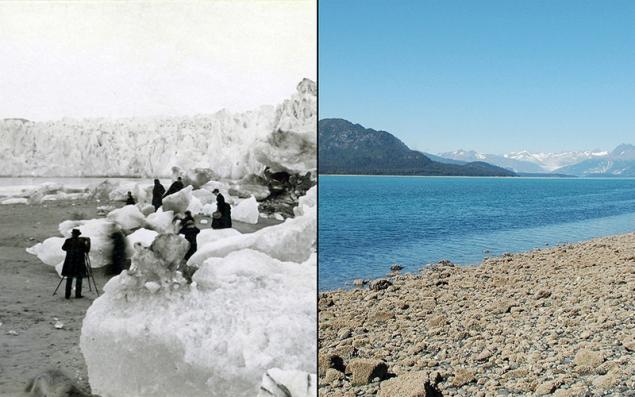
13. Pedersen glacier (Alaska) in 1917 and 2005
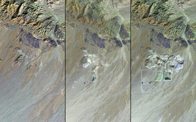
14. Gold mining in California
Gold mine Mesquite is one of the largest in the US — in 1982, 1987 and 2011. The precious metal then started to produce in 1957, and expanded production in 1986, (when prices of gold on world markets went up). According to the forecasts of geologists, the reserves of the metal was supposed to end by 1999, however, advanced technologies support the production. Is Mesquite in the Mojave desert. The effects of toxic wastes (especially cyanides) are carefully monitored by ecologists. Now the owners of the mine are planning to build near a large landfill for industrial waste.
15. Drying lakes
Lake Chad (Africa) in December 1972, 1987, 2002. Persistent drought has reduced the sixth-largest lake in the world to one-twentieth of its area in the 1960-ies. As the retreat of the lake at its shores formed the great swamp.
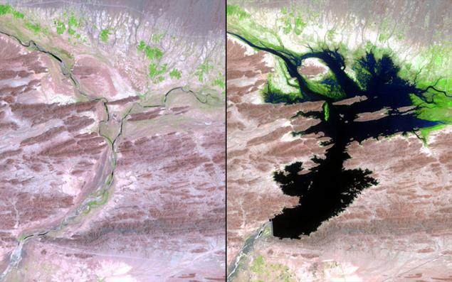
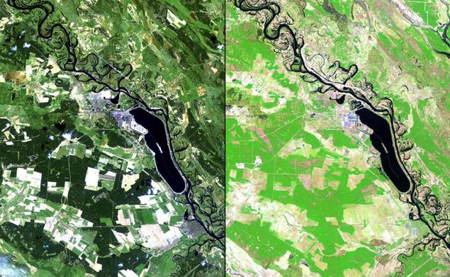
16. Dam
The Mirani dam on the Dasht river (Pakistan) was built in 2006. The new reservoir provides water for drinking, irrigation and hydropower operations. However, due to excessive precipitation in 2007 in the surrounding area, floods affected 15 thousand people. In pictures: Dasht before (1999) and after (2011) the construction of the dam (the abundance of greenery a new gardens and fields).
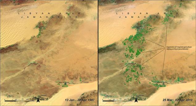
17. Great man-made river
South-Eastern Libya, 1987 and 2010. Opening in mid-century, the aquifers underneath the surface of the deserts of southern Libya led to the launch of the "great man-made river", one of the greatest engineering projects in the world: the system of pipes, aqueducts and wells (deeper than 500 meters). Complex network of water mains supplying desert areas with water.published
P. S. And remember, only by changing their consumption — together we change the world! ©
Source: bigpicture.ru/?p=645558
However, there were in the collection a place for the few achievements of mankind: from greening the Libyan desert with Gaddafi before the explosion in 1992, a Soviet dam, saved the unique Bay of Kara-Bogaz-Gol.

1. The Muir glacier (Alaska) in 1882 and 2005

2. Greening of the desert
Wadi As-Sirhan, Northern Saudi Arabia: February 1986 — February 2004. A huge desert area, where before barely making ends meet, residents of the two towns (al-Isawiya and Tubarjal is the upper left corner of the picture), a couple of decades turned into a blooming garden. Many fields are irrigated using a circular irrigation. The water in Al-Sirhan is taken from an ancient aquifer. Economical and efficient use of resources helped to create from scratch an agricultural area, and with minimal environmental damage.

3. Economy and coastline
The West coast of Mexico, 1993 and 2011. Over the past decade in the state of Sonora, has opened dozens of shrimp farms. Although the new industry brought to the region a lot of money and jobs, its impact on the ecosystem is a concern to scientists.

4. Echo Of Chernobyl
The surroundings of Chernobyl, April 1986 — April 2011. In the picture of the Soviet era are visible the fields ready for planting (bright tones), dense forest (dark green) and the small rural settlement (blue, purple tones). 25 years later the field became grassland (bright green), forests destroyed (in their place, however, planted new trees — shades of green), and all the settlements abandoned.

5. Melting ice in the Alps
Matterhorn peak (on the border between Switzerland and Italy) in August 1960 and 2005.

6. Global warming
On these maps, NASA compares the average temperature in each region of the world in 1880-1889 and 2000-2009. Data obtained from research ships, satellites and 6300 meteorological stations. Since 1880 the average temperature at the Earth's surface increased by 0.7 degrees Celsius, two-thirds of the growth came in the last 40 years.

7. The Rescue Of Kara-Bogaz-Gol
Kara-Bogaz-Gol Bay-lagoon of the Caspian sea in the West of Turkmenistan in 1972, 1987 and 2010. The largest Deposit of salts. The construction in 1980 of the dam, separating the Kara-Bogaz-Gol of the Caspian sea, led to the fall of the water level and the formation of "salt pot", zagryaznenie the salt of the soil and causes lung disease. In 1992 the dam was blown up, and the ecosystem began to recover gradually.

8. Air purification
Nitrogen dioxide (NO2) is a brownish gas, causing lung disease and is actively involved in the formation of other harmful substances. In the atmosphere it gets mainly from the burning of gasoline in automobile engines and coal in power plants. Due to new laws, technological progress and shifts in the U.S. economy, the concentration of NO2 in the atmosphere over the last decade is steadily declining (despite growing population and number of cars). The photo shows the Northern U.S. (the axis in Boston — Richmond), where once the highest levels of NO2.

9. Artificial Islands
In 2001, in Dubai, located on the coast of the Persian Gulf, began work on the creation of artificial Islands. By 2012 there three Islands in the shape of palm trees: palm Jumeirah, palm Jebel Ali, palm Deira and the archipelagos of "the World" and "universe" of the smaller Islands.

10. Farewell, the ice of Kilimanjaro!
Kilimanjaro — the highest mountain peak of Africa — in February 1993 and 2000. The picture shows how "shriveled" its ice cap.

11. Deforestation
The forest of Baban Rafi (Niger, Maradi region) in 1976 and 2007. Located on the southern edge of the Sahel Baban Rafi is characterized by a vegetation of mixed type (characteristic of savannas and semi-deserts). The images show how the natural landscape (dark green tones) gives way to agriculture. In 40 years the population has grown by 40 times, and with it the need for land for fields. Remnants of forests are actively cut down for firewood.

12. Saddam and the oil fields of Kuwait
The Sabria field in 1991 and 2011. Before retreating from Kuwait in 1991, Iraqi forces on the orders of Saddam Hussein set fire to about 700 oil wells. The combustion products were stained kilometers of soil in the black color (as seen in first picture). However, for 20 years, the ecosystem of the region recovered from the damage. The smoke in the second image — trace of the routine procedures of arson (with their help remove excess gases).

13. Pedersen glacier (Alaska) in 1917 and 2005

14. Gold mining in California
Gold mine Mesquite is one of the largest in the US — in 1982, 1987 and 2011. The precious metal then started to produce in 1957, and expanded production in 1986, (when prices of gold on world markets went up). According to the forecasts of geologists, the reserves of the metal was supposed to end by 1999, however, advanced technologies support the production. Is Mesquite in the Mojave desert. The effects of toxic wastes (especially cyanides) are carefully monitored by ecologists. Now the owners of the mine are planning to build near a large landfill for industrial waste.

15. Drying lakes
Lake Chad (Africa) in December 1972, 1987, 2002. Persistent drought has reduced the sixth-largest lake in the world to one-twentieth of its area in the 1960-ies. As the retreat of the lake at its shores formed the great swamp.

16. Dam
The Mirani dam on the Dasht river (Pakistan) was built in 2006. The new reservoir provides water for drinking, irrigation and hydropower operations. However, due to excessive precipitation in 2007 in the surrounding area, floods affected 15 thousand people. In pictures: Dasht before (1999) and after (2011) the construction of the dam (the abundance of greenery a new gardens and fields).

17. Great man-made river
South-Eastern Libya, 1987 and 2010. Opening in mid-century, the aquifers underneath the surface of the deserts of southern Libya led to the launch of the "great man-made river", one of the greatest engineering projects in the world: the system of pipes, aqueducts and wells (deeper than 500 meters). Complex network of water mains supplying desert areas with water.published
P. S. And remember, only by changing their consumption — together we change the world! ©
Source: bigpicture.ru/?p=645558


Memo for the nanny (but parents will also be useful!)
Why people whose home eternal chaos - the best of us