1202
How has our planet over the past 50 years
It - staloPredlagaem you some photo examples of how humanity has changed the planet Earth. Visually fruits of our labors are shown on a special website of NASA «Images of change» («Images of Change"), where he has made at intervals of years 5-10-50-100 photos (primarily satellite) show how it was - and it became. Melting glaciers, drying up lakes, coastal erosion, desertification ...
However, there was a place on the list for the few achievements of mankind, from the Libyan desert landscaping at Gaddafi before the bombing in 1992 of Soviet dams saved the unique Bay Garabogazköl.
Greening pustyni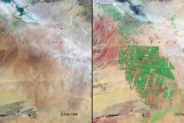
Wadi As-Sirhan, northern Saudi Arabia in February 1986 - February 2004. Vast desert area, where previously barely make ends meet residents of the two towns (Al-Isaviyya and Tubarzhal - upper left corner of the image), a couple of decades turned into a blooming garden. Many fields are irrigated by a circular irrigation. Water in Al Sirhan is taken from an ancient aquifer. Economical and rational use of resources has helped to create from scratch an agricultural area, and with minimal damage to the environment.
Economy and coastal liniya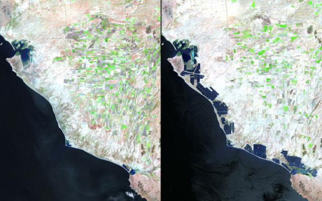
West Coast of Mexico, 1993 and 2011. In recent decades the State of Sonora opened dozens of shrimp farms. Although a new industry in the region has brought a lot of money and jobs, its impact on the ecosystem of a concern of scientists.
Echo Chernobylya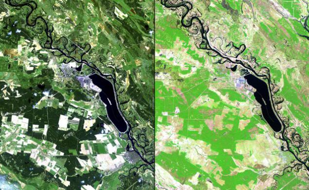
Neighborhoods Chernobyl, April 1986 - April 2011. In the picture of Soviet times can be seen ready for sowing field (bright colors), dense forests (dark green) and small rural settlements (blue, purple tones). 25 years later, the field began to meadows (bright green), forests destroyed (in their place, however, planted new trees - and shades of green), and all the inhabitants left the settlement.
Melting ice in Alpah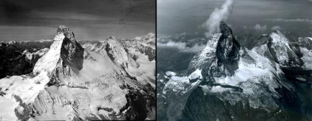
The peak of the Matterhorn (at the border between Switzerland and Italy) in August 1960 and 2005.
Global poteplenie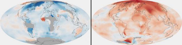
These maps NASA compared the average temperature in each region of the world in 1880-1889 and 2000-2009 respectively. Data collected with scientific ships, satellites and 6,300 weather stations. Since 1880, the average temperature at the Earth's surface has increased by 0, 7 degrees Celsius, two thirds of the growth occurred in the last 40 years.
Salvation Kara Bogas Gola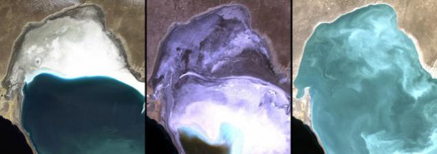
Garabogazköl - Bay lagoon of the Caspian Sea in the west of Turkmenistan in 1972, 1987 and 2010. The largest deposit of salts. The construction of the dam in 1980, separated the Garabogazköl from the Caspian Sea, has led to a drop in the water level and the formation of "salt boiler" polluting the soil with salt and causing lung disease. In 1992, the dam was blown up, and the ecosystem of the Gulf are gradually beginning to recover.
Cleansing vozduha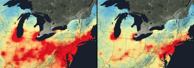
Nitrogen dioxide (NO2) - a gas of brown color that causes lung disease and is actively involved in the formation of other harmful substances. In the atmosphere it gets mainly from the burning of gasoline in car engines and coal power plants. With the new laws, technological advances and shifts in the US economy, the NO2 concentration in the atmosphere over the last decade steadily declining (despite the increase in population and number of vehicles). In the picture - the northern United States (Boston Richmond-axis), which once had the highest levels of NO2.
Artificial ostrova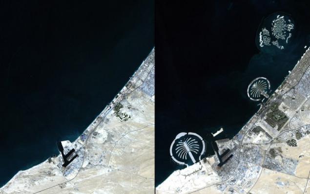
In 2001, in Dubai, located on the Persian Gulf coast, work began on the creation of an artificial archipelago. By 2012 there was already three islands in the shape of palms: Palm Jumeirah, Palm Jebel Ali, Palm Deira - as well as the archipelagos of "The World" and "Universe" of the smaller islands.
Farewell, ice Kilimanjaro!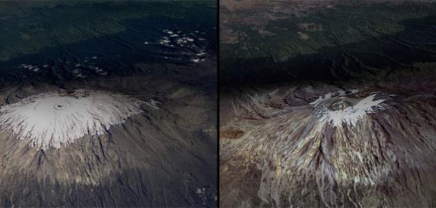
Kilimanjaro - the highest mountain peak in Africa - in February 1993 and 2000. The picture shows how "shrunk" its ice cap.
Obezlesenie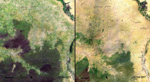
Forest Baban Rafi (Niger Maradi region) in 1976 and 2007. Located on the southern edge of the Sahel Baban Rafi different vegetation mixed type (characteristic of savannas and semi-deserts). The pictures can be seen as the natural landscape (dark greens) gives way to agriculture. For 40 years, the region's population has grown by 40 times, and with it - and the need for land for fields. The remains of the forest is actively being cut down for firewood.
Saddam and oilfields Kuveyta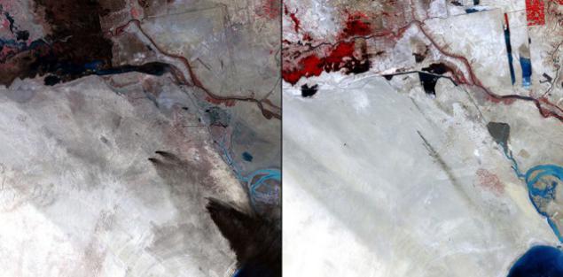
Sabria field in 1991 and 2011. Before the retreat from Kuwait in 1991, Iraqi troops on the orders of Saddam Hussein set fire to 700 oil wells. Combustion products kilometers of soil stained in black (as seen in the first picture). However, in 20 years the ecosystem of the region as a whole has recovered from the damage. Smoke in the second image - a trace of routine procedures arson (with their help clean the excess gas).
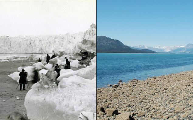
Pedersen Glacier (Alaska) in 1917 and 2005, godu
Gold mining in Kalifornii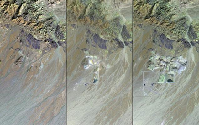
Mesquite Gold Mine - one of the largest in the US - in 1982, 1987 and 2011. Precious metal immediately began to produce in 1957, and expanded production in 1986 (when the price of gold on world markets went up). According to the forecasts of geologists, the reserves of the metal have been completed by 1999, but improved technology for production support. Mesquite is located in the Mojave Desert. Exposure to toxic waste (primarily cyanides) carefully monitored by ecologists. Now the owners of the mine plan to build near a major testing ground for industrial waste.
Drying ozer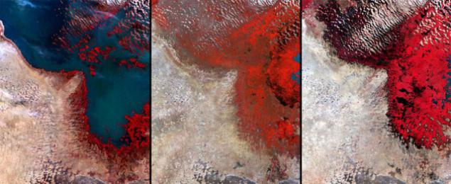
Lake Chad (Africa) in December 1972, 1987, 2002. Persistent drought reduced the sixth largest lake in the world to one twentieth of its area in the 1960s. With the retreat of the lake from its shores formed the extensive swamps.
Plotina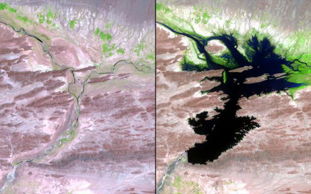
Mirani Dam on the river Dasht (Pakistan) was built in 2006. The new reservoir provides water for drinking, irrigation and hydroelectric works. However, due to excessive rainfall in 2007 in the surrounding areas have become the victims of the flood 15 thousand people. In pictures: Dasht before (1999) and after (2011) the construction of a dam (the abundance of greenery - the new gardens and fields).
Great Man-Made reka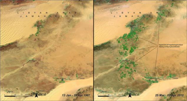
South-eastern Libya, 1987 and 2010. Opening in mid-century aquifers beneath the surface of the southern deserts of Libya has led to the launch of "Great Man-Made River," one of the greatest engineering projects in the world, a system of pipes, aqueducts and wells to a depth of over 500 meters. A complex network of water mains supplying water desert areas.
via lenta.ru/photo/2015/06/05/change
However, there was a place on the list for the few achievements of mankind, from the Libyan desert landscaping at Gaddafi before the bombing in 1992 of Soviet dams saved the unique Bay Garabogazköl.

Greening pustyni

Wadi As-Sirhan, northern Saudi Arabia in February 1986 - February 2004. Vast desert area, where previously barely make ends meet residents of the two towns (Al-Isaviyya and Tubarzhal - upper left corner of the image), a couple of decades turned into a blooming garden. Many fields are irrigated by a circular irrigation. Water in Al Sirhan is taken from an ancient aquifer. Economical and rational use of resources has helped to create from scratch an agricultural area, and with minimal damage to the environment.
Economy and coastal liniya

West Coast of Mexico, 1993 and 2011. In recent decades the State of Sonora opened dozens of shrimp farms. Although a new industry in the region has brought a lot of money and jobs, its impact on the ecosystem of a concern of scientists.
Echo Chernobylya

Neighborhoods Chernobyl, April 1986 - April 2011. In the picture of Soviet times can be seen ready for sowing field (bright colors), dense forests (dark green) and small rural settlements (blue, purple tones). 25 years later, the field began to meadows (bright green), forests destroyed (in their place, however, planted new trees - and shades of green), and all the inhabitants left the settlement.
Melting ice in Alpah

The peak of the Matterhorn (at the border between Switzerland and Italy) in August 1960 and 2005.
Global poteplenie

These maps NASA compared the average temperature in each region of the world in 1880-1889 and 2000-2009 respectively. Data collected with scientific ships, satellites and 6,300 weather stations. Since 1880, the average temperature at the Earth's surface has increased by 0, 7 degrees Celsius, two thirds of the growth occurred in the last 40 years.
Salvation Kara Bogas Gola

Garabogazköl - Bay lagoon of the Caspian Sea in the west of Turkmenistan in 1972, 1987 and 2010. The largest deposit of salts. The construction of the dam in 1980, separated the Garabogazköl from the Caspian Sea, has led to a drop in the water level and the formation of "salt boiler" polluting the soil with salt and causing lung disease. In 1992, the dam was blown up, and the ecosystem of the Gulf are gradually beginning to recover.
Cleansing vozduha

Nitrogen dioxide (NO2) - a gas of brown color that causes lung disease and is actively involved in the formation of other harmful substances. In the atmosphere it gets mainly from the burning of gasoline in car engines and coal power plants. With the new laws, technological advances and shifts in the US economy, the NO2 concentration in the atmosphere over the last decade steadily declining (despite the increase in population and number of vehicles). In the picture - the northern United States (Boston Richmond-axis), which once had the highest levels of NO2.
Artificial ostrova

In 2001, in Dubai, located on the Persian Gulf coast, work began on the creation of an artificial archipelago. By 2012 there was already three islands in the shape of palms: Palm Jumeirah, Palm Jebel Ali, Palm Deira - as well as the archipelagos of "The World" and "Universe" of the smaller islands.
Farewell, ice Kilimanjaro!

Kilimanjaro - the highest mountain peak in Africa - in February 1993 and 2000. The picture shows how "shrunk" its ice cap.
Obezlesenie

Forest Baban Rafi (Niger Maradi region) in 1976 and 2007. Located on the southern edge of the Sahel Baban Rafi different vegetation mixed type (characteristic of savannas and semi-deserts). The pictures can be seen as the natural landscape (dark greens) gives way to agriculture. For 40 years, the region's population has grown by 40 times, and with it - and the need for land for fields. The remains of the forest is actively being cut down for firewood.
Saddam and oilfields Kuveyta

Sabria field in 1991 and 2011. Before the retreat from Kuwait in 1991, Iraqi troops on the orders of Saddam Hussein set fire to 700 oil wells. Combustion products kilometers of soil stained in black (as seen in the first picture). However, in 20 years the ecosystem of the region as a whole has recovered from the damage. Smoke in the second image - a trace of routine procedures arson (with their help clean the excess gas).
Pedersen Glacier (Alaska) in 1917 and 2005, godu

Gold mining in Kalifornii

Mesquite Gold Mine - one of the largest in the US - in 1982, 1987 and 2011. Precious metal immediately began to produce in 1957, and expanded production in 1986 (when the price of gold on world markets went up). According to the forecasts of geologists, the reserves of the metal have been completed by 1999, but improved technology for production support. Mesquite is located in the Mojave Desert. Exposure to toxic waste (primarily cyanides) carefully monitored by ecologists. Now the owners of the mine plan to build near a major testing ground for industrial waste.
Drying ozer

Lake Chad (Africa) in December 1972, 1987, 2002. Persistent drought reduced the sixth largest lake in the world to one twentieth of its area in the 1960s. With the retreat of the lake from its shores formed the extensive swamps.
Plotina

Mirani Dam on the river Dasht (Pakistan) was built in 2006. The new reservoir provides water for drinking, irrigation and hydroelectric works. However, due to excessive rainfall in 2007 in the surrounding areas have become the victims of the flood 15 thousand people. In pictures: Dasht before (1999) and after (2011) the construction of a dam (the abundance of greenery - the new gardens and fields).
Great Man-Made reka

South-eastern Libya, 1987 and 2010. Opening in mid-century aquifers beneath the surface of the southern deserts of Libya has led to the launch of "Great Man-Made River," one of the greatest engineering projects in the world, a system of pipes, aqueducts and wells to a depth of over 500 meters. A complex network of water mains supplying water desert areas.
via lenta.ru/photo/2015/06/05/change