951
Best pictures from space per month (12 photos)
The best photos of the month made satellites NASA and the European Space Agency.
In this photo subtropical Canary Islands off the west coast of Africa. The picture was taken on September 8, 2011. To the north of the dark blue water, you can see multiple traces of the aircraft. To the west, in the desert plains of Morocco and the Western Sahara. To the northwest stretches Portuguese archipelago of Madeira.
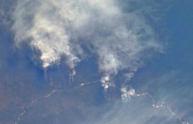
Slash-and-burn farming practices along the Xingu River in the state of Mato Grosso, Brazil. This process is the burning of forests and the release of land for future use it for planting crops. This method makes the usually poor soils of tropical forests (and there are a lot of soil on the planet) suitable for agriculture. It encourages people to turn forests into agricultural land. Burning area can be significant. Since then, as deforested regions became possible to set and measure from space, it is possible to trace the extent of deforestation. Light areas in the river bed is sand dunes, which show that the river is under annual shoaling.
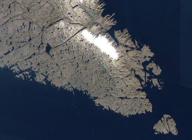
The annual celebration of the discovery of America by Europeans, Leif Erikson Day is celebrated on October 9 in honor of Viking explorers who sailed with his crew became the first European to visit North America about 1,000 years ago. There is some evidence that the trader named Bjarni Herjólfsson first reached the shores of America in the year 985, after being blown off course en route from Iceland to Greenland. Story Heryulfssona allegedly inspired by Erickson for a swim, and he went to sea about 15 years later. The Scandinavian legends, Erickson first landed on the "land of flat stones," or Helluland. This rocky, flat, scarcely vegetated land is now considered to Baffin Island. Not knowing what lies ahead, the expedition Erickson went on a long voyage to the south, opening Markland (apparently, Labrador) and Vinland (Newfoundland).
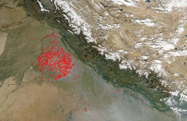
In northern India in the midst of fire season. Multiple foci of fire burning near the Pakistani border. Most of them are located in the state of Punjab, which is only about 2% of the country, but where grown more than 50% of the grain. During the monsoon season, which usually runs from June to November, heavy rains hamper agriculture. After their completion, farmers begin to cook the soil for planting. Traditionally, the ground is prepared with fire. This shoe has a lot of harmful effects. The most obvious of these is the air pollution. The photo shows how the wind blows the smoke from the burning land in the south-east region tightening thick smog. Himalayan Mountains are a major obstacle to the penetration of the air flow, locking the polluted air on the south side, where it is collected and mixed with contaminated vehicles and industrial plants.
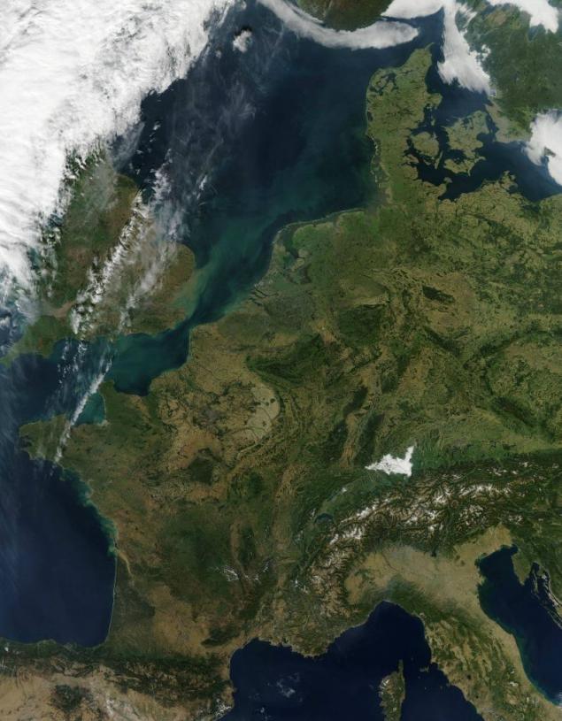
The palette of autumn colors in Eastern Europe sunny morning October 1, 2011. In some areas of this region dark green summer forest gently softened light green and yellow withering leaves falling trees. Alps in the south lie under a blanket of snow, and in the north you can see the bright white area with smooth edges. It's not snow, and fog formation of the evening, which covers Constance (Constance) Lake and the surrounding valley. Coast of the lake is divided among three countries. Austria to the south-west, the north of Germany and Switzerland in the south. Although the lake with a width of about 14 km at its widest point, it often blocks the review of companion haze and fog.
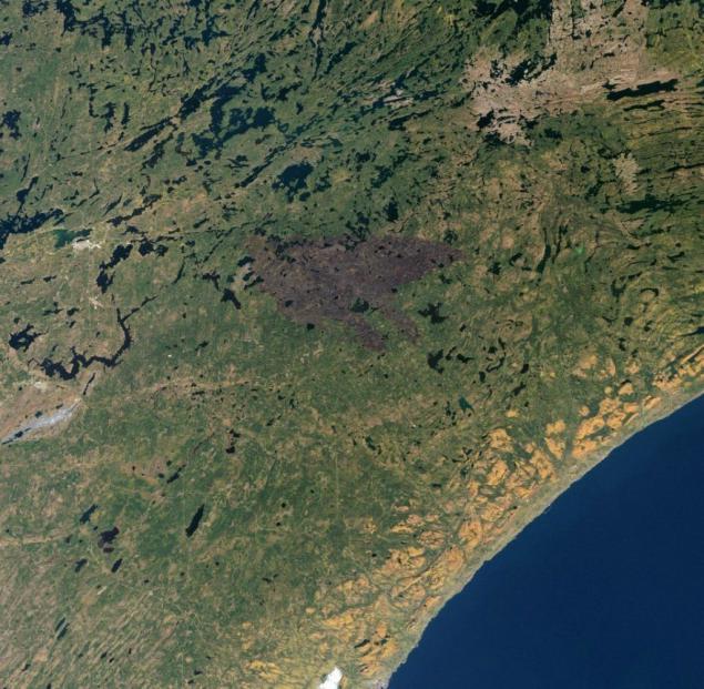
Nearly two months after the ignition from lightning fire in the territory in the north of the bay Pagami Minnesota was almost stopped on 10 October. On August 18 the fire was burning in the reserve Boundary Waters Canoe Area Wilderness in the Superior National Forest. October 11, the fire had burned 375 square meters. km (82 area%). Not far from the weak haze can still be seen small pockets of fire. Dark area burnt forest stands out against the green background.
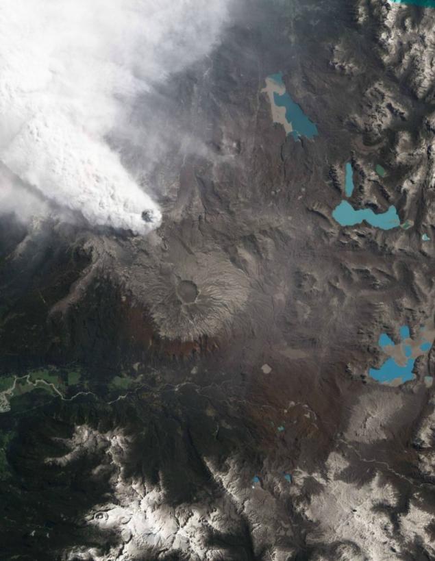
Chilean volcano Puyehue-Cordon Caulle continues to erupt. In late October of smoke were smaller than in the initial stages of the eruption in early June. Then the height of the eruption reached 4, 5 km. However, the high atmospheric wind spread the ash and disrupt air traffic in the region. Depending on the wind strength ash spreads from vents around the neighborhood at a distance of 120-250 km.
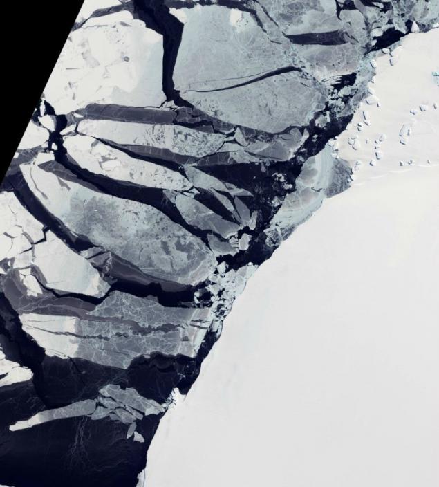
Although it is all frozen water, ice is not the same. Picture taken on October 7 off the coast of East Antarctica. Brilliant white ice fills the right half of the picture. This fast ice that sets and still is on the shore. This ice is thick enough to completely hide under sea water, hence his brilliant white color. Near seen trapped in fast ice and icebergs are stuck in it. Ice shelves may vary in thickness from tens to hundreds of meters. Water-saturated ice has a blue tint. Icebergs along the edge of the fast ice, probably settled in shallow seabed, their presence helps to keep the fast ice in place. Next comes the sea ice that drifts with the wind speed downstream. It is much thinner than fast ice, translucent, of different shades of blue-gray color.
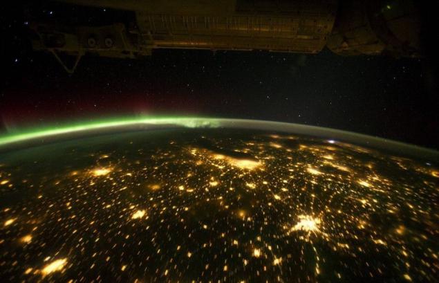
Night sky illuminated by a plurality of lights. For example, the US Midwest during the night, if you look at it from orbit that looks a little different from the quilt. Artificial light is lit settlements characteristic yellow light. Green northern lights shining brightly on the horizon - it seems even reflects the outlines of Canada. Small white speck of light is almost certainly the lightning from the storm on the East Coast. In this image, the largest concentration of lights belongs to the metropolis of Chicago. Dark spot near - Lake Michigan. Other major regions, which are also visible in the picture - this is St. Louis, Minneapolis - St. Paul and Omaha - Council Bluffs. North-eastern border of the coast is just around the corner Appalachian dark areas devoid of large cities.
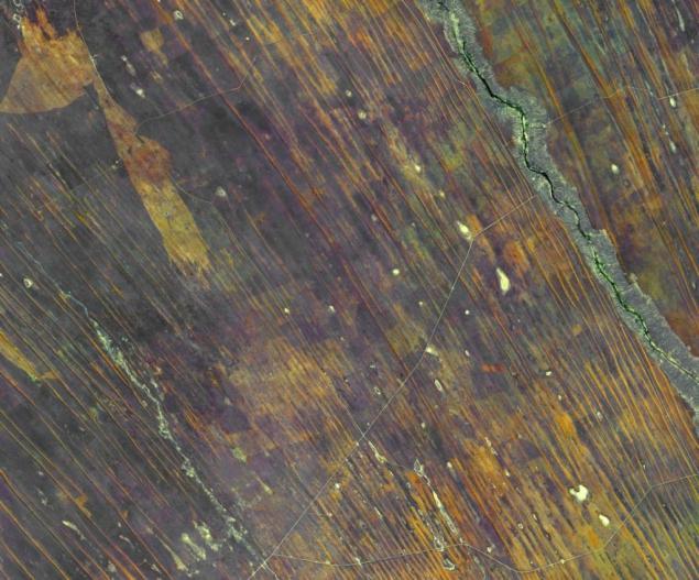
Northern Namibia is known for its open and winding extending parallel dunes, most of which are red
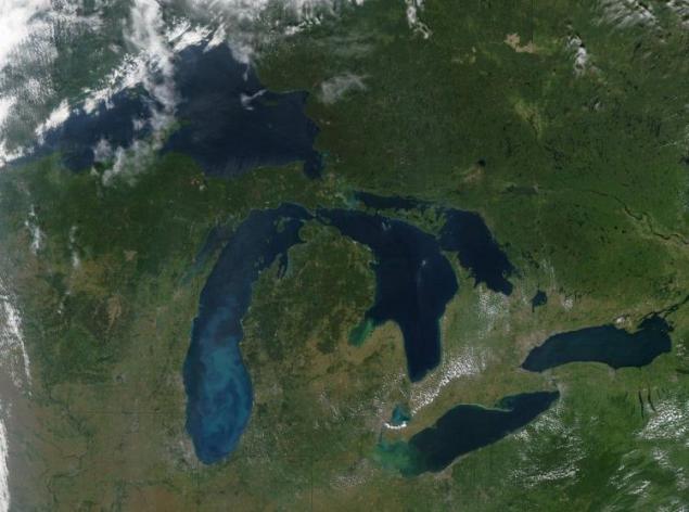
The photograph of the Great Lakes in the water can be seen glistening streaks of blue and green colors. Blue streaks in lakes Michigan and Huron is sediment brought to the surface by strong winds October 9, 2011. Green spots in Lake Erie and Lake Huron to Saginaw Bay is algae that float on the surface at the quiet winds. The precipitate was often stain the Great Lakes in the spring and fall, when the weather brings severe storms and wind. Wind stirred water, and from the bottom surface and extends yl sand. White sand looks milky blue, if you look at it through the water from space. Precipitation may be pale blue areas on Lake Erie, and the green area - a large area of algal blooms. Currently algae bloom in most of the western half of the lake. Although satellite image can not tell us what kind of algae grows in Lake Erie, however, water samples show that bloom here mainly toxic algae.
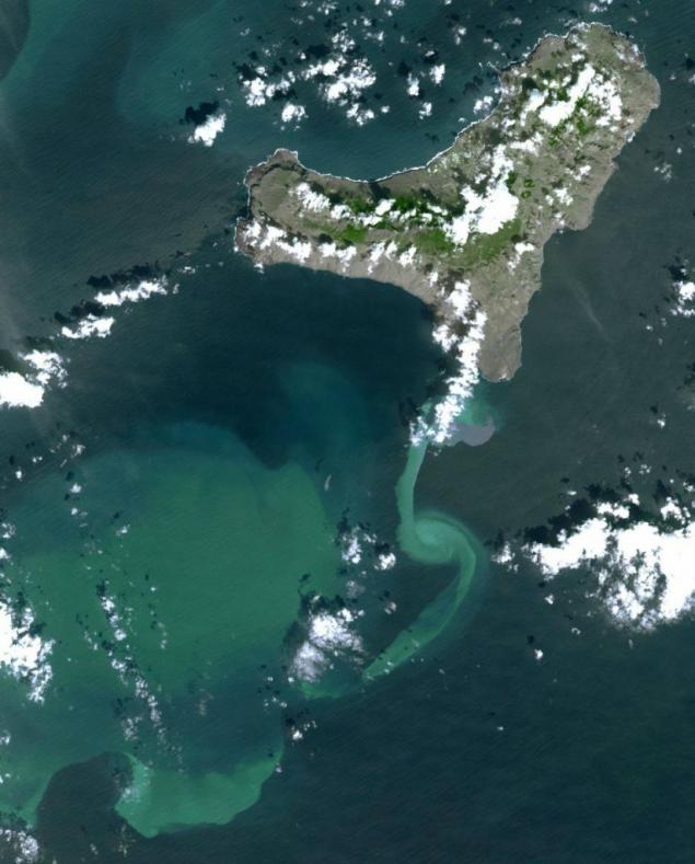
In July 2011 volcanic tremors began to shake the island of El Hierro, which is part of the Canary Islands. Fearing the eruption, by September this resort island left all the tourists. In early October, an underwater volcano erupted, throwing the ashes into the sea and chemicals. This has resulted in water color to the south of the island in a dirty shade.
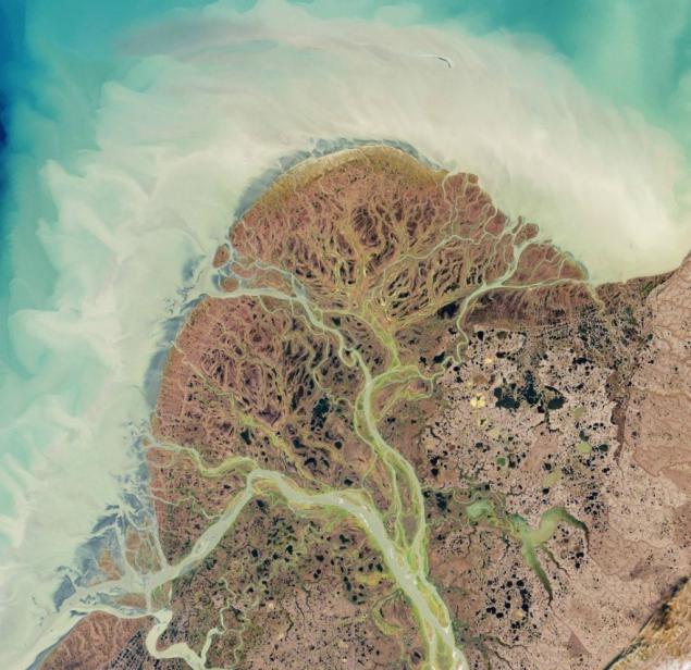
Yukon River originates in British Columbia, Canada, and flows through the Yukon Territory, and then to Alaska. In southwest Alaska tundra stretches over a vast plain of the Yukon Delta, where the Yukon and Kuskokwim River meandering flow toward the Bering Sea. A bit like a partially branched and finding each other blood vessels, rivers and streams along the winding canals flowing to the sea, walking and feeding a lot of coastal ponds and lakes. Flowing through this low-lying, mostly devoid of trees, terrain, rivers are often able to change its trajectory, paving his new shortest route to the sea. Grassy plain not only provided a corridor for migration of animals and plants, but also became the home of the ancestors of today's Americans. People have been living there for thousands of years. Yukon Delta is one of the densely populated rural regions of Alaska, home to thousands of Yupik Eskimo.
Source
In this photo subtropical Canary Islands off the west coast of Africa. The picture was taken on September 8, 2011. To the north of the dark blue water, you can see multiple traces of the aircraft. To the west, in the desert plains of Morocco and the Western Sahara. To the northwest stretches Portuguese archipelago of Madeira.

Slash-and-burn farming practices along the Xingu River in the state of Mato Grosso, Brazil. This process is the burning of forests and the release of land for future use it for planting crops. This method makes the usually poor soils of tropical forests (and there are a lot of soil on the planet) suitable for agriculture. It encourages people to turn forests into agricultural land. Burning area can be significant. Since then, as deforested regions became possible to set and measure from space, it is possible to trace the extent of deforestation. Light areas in the river bed is sand dunes, which show that the river is under annual shoaling.

The annual celebration of the discovery of America by Europeans, Leif Erikson Day is celebrated on October 9 in honor of Viking explorers who sailed with his crew became the first European to visit North America about 1,000 years ago. There is some evidence that the trader named Bjarni Herjólfsson first reached the shores of America in the year 985, after being blown off course en route from Iceland to Greenland. Story Heryulfssona allegedly inspired by Erickson for a swim, and he went to sea about 15 years later. The Scandinavian legends, Erickson first landed on the "land of flat stones," or Helluland. This rocky, flat, scarcely vegetated land is now considered to Baffin Island. Not knowing what lies ahead, the expedition Erickson went on a long voyage to the south, opening Markland (apparently, Labrador) and Vinland (Newfoundland).

In northern India in the midst of fire season. Multiple foci of fire burning near the Pakistani border. Most of them are located in the state of Punjab, which is only about 2% of the country, but where grown more than 50% of the grain. During the monsoon season, which usually runs from June to November, heavy rains hamper agriculture. After their completion, farmers begin to cook the soil for planting. Traditionally, the ground is prepared with fire. This shoe has a lot of harmful effects. The most obvious of these is the air pollution. The photo shows how the wind blows the smoke from the burning land in the south-east region tightening thick smog. Himalayan Mountains are a major obstacle to the penetration of the air flow, locking the polluted air on the south side, where it is collected and mixed with contaminated vehicles and industrial plants.

The palette of autumn colors in Eastern Europe sunny morning October 1, 2011. In some areas of this region dark green summer forest gently softened light green and yellow withering leaves falling trees. Alps in the south lie under a blanket of snow, and in the north you can see the bright white area with smooth edges. It's not snow, and fog formation of the evening, which covers Constance (Constance) Lake and the surrounding valley. Coast of the lake is divided among three countries. Austria to the south-west, the north of Germany and Switzerland in the south. Although the lake with a width of about 14 km at its widest point, it often blocks the review of companion haze and fog.

Nearly two months after the ignition from lightning fire in the territory in the north of the bay Pagami Minnesota was almost stopped on 10 October. On August 18 the fire was burning in the reserve Boundary Waters Canoe Area Wilderness in the Superior National Forest. October 11, the fire had burned 375 square meters. km (82 area%). Not far from the weak haze can still be seen small pockets of fire. Dark area burnt forest stands out against the green background.

Chilean volcano Puyehue-Cordon Caulle continues to erupt. In late October of smoke were smaller than in the initial stages of the eruption in early June. Then the height of the eruption reached 4, 5 km. However, the high atmospheric wind spread the ash and disrupt air traffic in the region. Depending on the wind strength ash spreads from vents around the neighborhood at a distance of 120-250 km.

Although it is all frozen water, ice is not the same. Picture taken on October 7 off the coast of East Antarctica. Brilliant white ice fills the right half of the picture. This fast ice that sets and still is on the shore. This ice is thick enough to completely hide under sea water, hence his brilliant white color. Near seen trapped in fast ice and icebergs are stuck in it. Ice shelves may vary in thickness from tens to hundreds of meters. Water-saturated ice has a blue tint. Icebergs along the edge of the fast ice, probably settled in shallow seabed, their presence helps to keep the fast ice in place. Next comes the sea ice that drifts with the wind speed downstream. It is much thinner than fast ice, translucent, of different shades of blue-gray color.

Night sky illuminated by a plurality of lights. For example, the US Midwest during the night, if you look at it from orbit that looks a little different from the quilt. Artificial light is lit settlements characteristic yellow light. Green northern lights shining brightly on the horizon - it seems even reflects the outlines of Canada. Small white speck of light is almost certainly the lightning from the storm on the East Coast. In this image, the largest concentration of lights belongs to the metropolis of Chicago. Dark spot near - Lake Michigan. Other major regions, which are also visible in the picture - this is St. Louis, Minneapolis - St. Paul and Omaha - Council Bluffs. North-eastern border of the coast is just around the corner Appalachian dark areas devoid of large cities.

Northern Namibia is known for its open and winding extending parallel dunes, most of which are red

The photograph of the Great Lakes in the water can be seen glistening streaks of blue and green colors. Blue streaks in lakes Michigan and Huron is sediment brought to the surface by strong winds October 9, 2011. Green spots in Lake Erie and Lake Huron to Saginaw Bay is algae that float on the surface at the quiet winds. The precipitate was often stain the Great Lakes in the spring and fall, when the weather brings severe storms and wind. Wind stirred water, and from the bottom surface and extends yl sand. White sand looks milky blue, if you look at it through the water from space. Precipitation may be pale blue areas on Lake Erie, and the green area - a large area of algal blooms. Currently algae bloom in most of the western half of the lake. Although satellite image can not tell us what kind of algae grows in Lake Erie, however, water samples show that bloom here mainly toxic algae.

In July 2011 volcanic tremors began to shake the island of El Hierro, which is part of the Canary Islands. Fearing the eruption, by September this resort island left all the tourists. In early October, an underwater volcano erupted, throwing the ashes into the sea and chemicals. This has resulted in water color to the south of the island in a dirty shade.

Yukon River originates in British Columbia, Canada, and flows through the Yukon Territory, and then to Alaska. In southwest Alaska tundra stretches over a vast plain of the Yukon Delta, where the Yukon and Kuskokwim River meandering flow toward the Bering Sea. A bit like a partially branched and finding each other blood vessels, rivers and streams along the winding canals flowing to the sea, walking and feeding a lot of coastal ponds and lakes. Flowing through this low-lying, mostly devoid of trees, terrain, rivers are often able to change its trajectory, paving his new shortest route to the sea. Grassy plain not only provided a corridor for migration of animals and plants, but also became the home of the ancestors of today's Americans. People have been living there for thousands of years. Yukon Delta is one of the densely populated rural regions of Alaska, home to thousands of Yupik Eskimo.
Source
Guess what it is (3 photos)
Guinness record for the largest street 3D-drawing in the world (18 photos)


