630
Earth "Then" and "Now": dramatic changes in NASA Photographs
The appearance of the world, as we know, is constantly changing due to a dozen different factors. One of them - global warming - many are skeptical, classify it to the category of the hypothetical. Scientists from NASA have decided to try to prove the opposite with the help of photographs showing how to change the face of the earth over the past years and decades. However, Business Insider publication offers to see the best images from the space agency's collections.
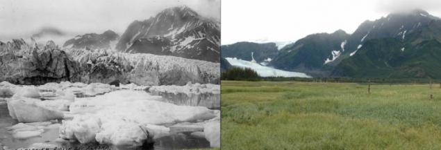
< Petersen Glacier, Alaska
Photo on the left was taken in August 1917, in the picture on the right - in August of 2005. For 88 years the glacier is almost nothing left.
McCarthy Glacier, Alaska
A similar story, and another giant ice with Alaska - Glacier McCarthy. The picture on the left is dated July 1909. The second photo was taken in August 2004. The area "retreat" of the glacier took more than 15 kilometers.
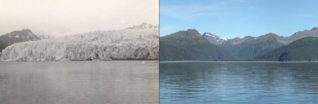
For the state of glaciers in Alaska, scientists monitored 50-ies of the last century. On average, according to researchers, the ice is melting at a rate of about 1, 8 meters per year. However, over the past decade, this figure began to increase. According to scientists from the Argentine University, the melting of glaciers in these volumes is the first time in the last 12 thousand years.
< Mount Matterhorn, Italy / Switzerland
Highly evolved over the past 45 years and the Matterhorn mountain located on the border of Italy and Switzerland. 4478-meter high pile - one of the most extreme climbing areas - significantly diminished in the "Champion»
.
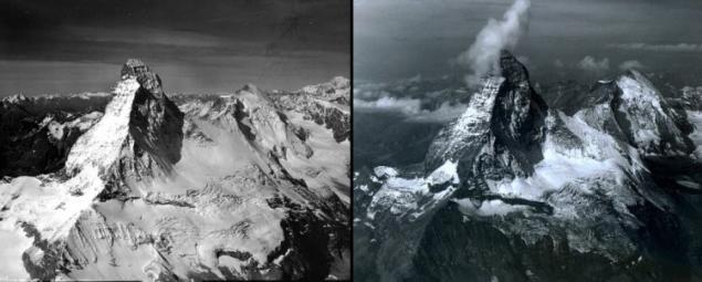
According to the Italian meteorologist Luke Mercan, who studied the behavior of the mountains in the last decade, accelerated melting of ice is much the summer of 2003 - because of abnormally warm weather. And one of the most serious consequences of this trend began to crack in the rocks and rock falls.
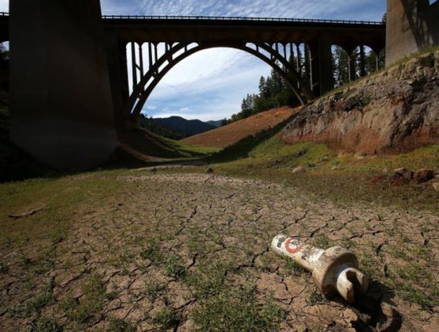
< Elephant Butte Reservoir, USA
Worst since 1972. The situation in the Elephant Butte Reservoir, located along the Rio Grande in New Mexico. The two pictures show how the reservoir has changed in 19 years - from 1993 to 2004
.
In 2009, the US Federal Bureau of Reclamation has prepared a package of proposals for the preservation of the reservoir and improve the situation. Today Elephant Butte should provide water Texan city of El Paso, and 35,000 hectares of agricultural land. With these objectives Elephant Butte cope with difficulty.
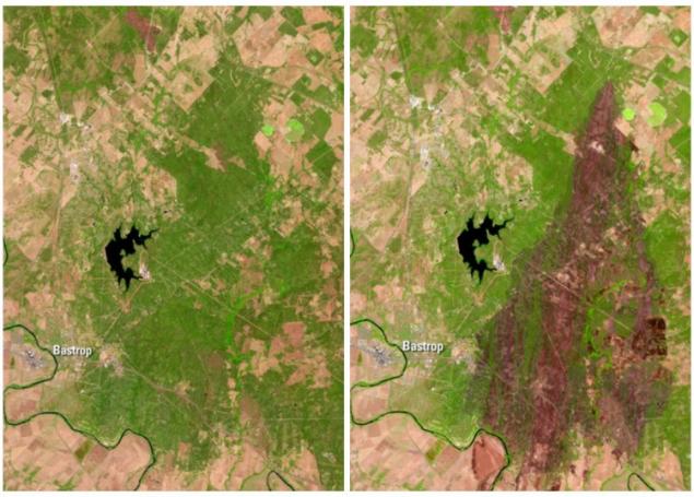
< Bastrop, Texas
Greatly changed the look of the Texas Bastrop County after the summer drought caused by the 2011 forest fires that have destroyed 13,111 hectares of forests and nearly 20 million homes. This fire was the largest in the history of Texas.
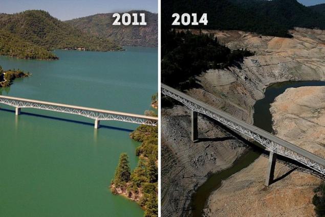
Lake Oroville, California
In just three years in the US Lake Oroville has lost about 70% of its volume. Photo on the left was made in July 2011. The picture on the right is dated August 2014 year.
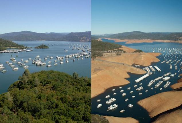
And here are a couple of photos taken from a different angle, which allow better understanding of the extent of the tragedy.
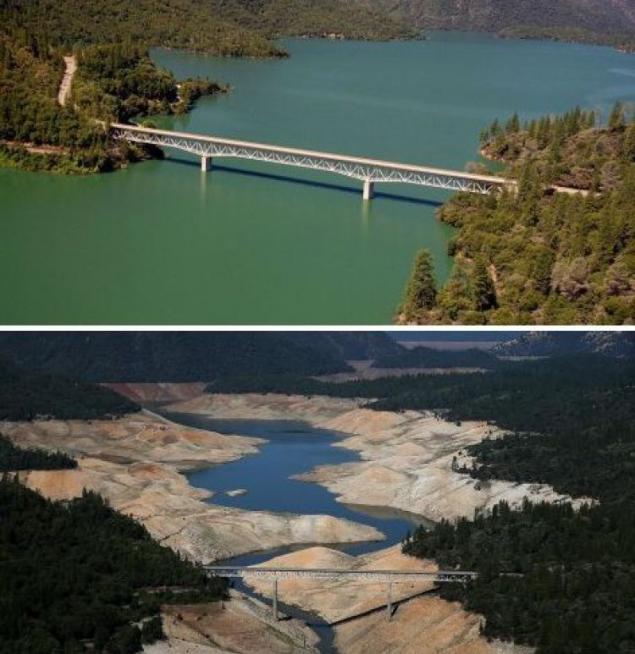
By the way, it turned out to be in a similar situation and other California Shasta Lake - the largest in the country. In 2014, the reservoir was nearly half-emptied. Where once there was water, there was only a sun-scorched land. White plastic object in the photo - a fragment of the buoy
.
The federal Bureau of Reclamation concluded that 2014 was the driest for California in the last hundred years.
< Lake Mar Chiquita, Argentina
Salt Lake Mar Chiquita, which is often called "the little sea", in the last 13 years has lost almost half the volume. The cause was a drought and irrigation.
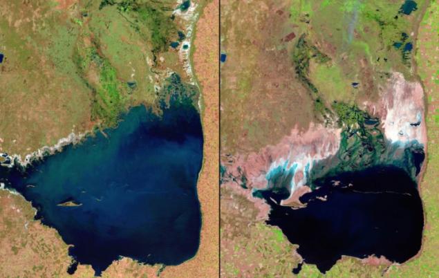
One of the consequences of reducing the volume of water in the lake began to dust storms. By the way, due to the drying of the lake becomes saltier with each passing year.
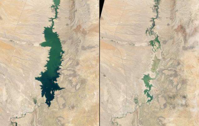
< Aral Sea, Kazakhstan / Uzbekistan
Another salt lake, elevated to the rank of the sea, is on the verge of extinction. Located on the border of Uzbekistan and Kazakhstan, Aral sea began to dry up in the middle of the last century. In 1960, its area was 70 sq. M. kilometers. In 1989, due to the drying sea split into two parts: small and large. By the beginning of the new millennium, the two seas area was 14 sq. M. kilometers and 20 respectively.
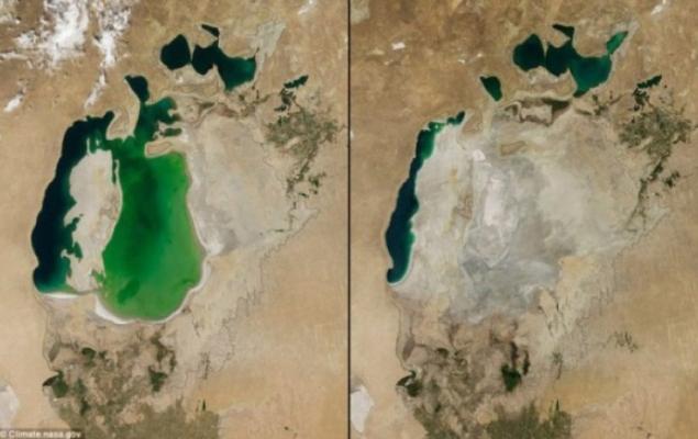
Sea drying up due to climate change and the construction of many canals for irrigation of agricultural land, has led to the disappearance of almost all species of fish and the occurrence of sandstorms.
In the photo - "dehydrated" Aral Sea areas
.

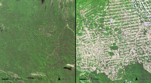
Forest in Rondônia, Brazil
Active influence of a changing climate on the face of the planet does not diminish at the same time and the "merits" of man. Another good example of how we impact on the face of the planet, radically changing it thus, can serve as a history of Rondônia - one of the youngest Brazilian states. He grew up just a few decades at the site once the impenetrable jungles of the Amazon. Of course, the main disadvantage was the emergence of a new state of the mass felling of rainforests.
Photo on the left is made in 1975. A picture on the right, which captured a new state - in 2009.
Loading ... Loading ...
Liked? Share with your friends!
Loading ... Loading ...


Worst Dresses Women's Eyes on the example of Celebrity Men
Golden Carriage, statues and toilet or "absurd Luxury World Rulers"