1338
Top 20 beautiful locations around the world. Part 1
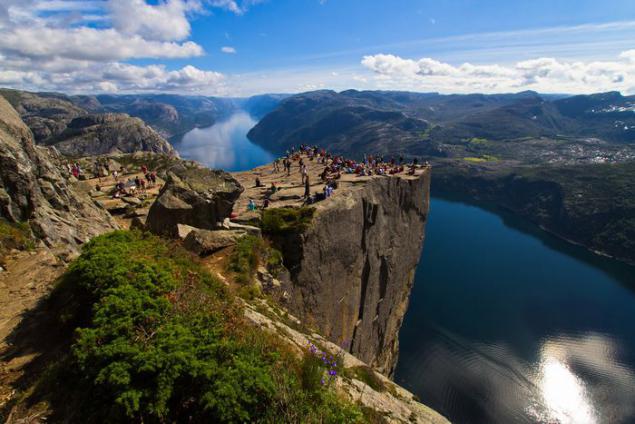
Lysefjord
The name of this fjord is translated as "bright fjord". This is explained by the fact that the coast is framed by bright granite skaly.Zaliv stretches for 42 kilometers, and its maximum depth is 420 m. The Lysefjord is known for its wildness and inaccessibility of majestic cliffs, from the tops of which offer incredible views
Sognefjord
It is the largest fjord in Europe and the second largest in the world, second only to Scoresby in Greenland. The length of the Sognefjord is 204 km, and in some places you can get to the bottom at a depth of only 1,308 meters.
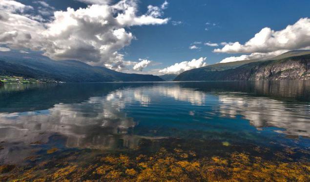
Hardanger Fjord is the third largest fjord in the world. In this region of Norway milder climate. This fjord is remarkable in that its shores are divided orchards. Nevertheless, even in summer you can ski on the glaciers of the Hardanger Fjord. Hardangervidda - a favorite summer pasture of wild reindeer.
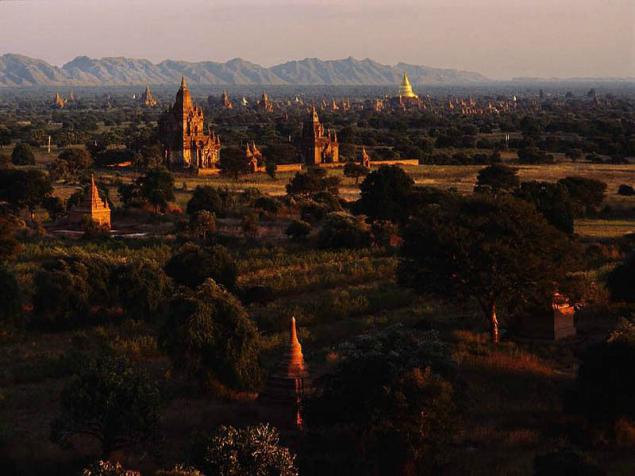
19th place. Pagan Magway Region, Myanmar (Burma)
Pagan (Bagan or) - the ancient capital of the eponymous kingdom in what is now Myanmar. The city is located on a dry plateau along the west bank of the Irrawaddy River, southeast of Mandalay, near the town of Chowk in Magway District. Currently, the site of the ancient city is the archaeological zone with thousands of pagodas, temples, stupas and monasteries. Pagan ruins cover an area of about 40 km2.
Most buildings were built during the XI-XIII centuries, when Bagan was the capital of dynastic kingdoms. King Pinbya at the end of IX century, suffered in the capital of Bagan. However, transferring the capital to the Burmese history occurred often, and in the XI century Anoratha king moved the capital to another city. Anoratha Pagan decided to turn into a cultural center. It approved the teaching of Theravada Buddhism as the state religion and spiritual mission sent to Sri Lanka, where the monks came and helped him complete treatment of the whole country in the Theravada. Bagan became the center of science, religion and culture, one of the largest cities in the world. At the end of the XIII century the kingdom was occupied by the Mongols. The city has been looted, stripped off the gold pagodas, numerous religious relics were stolen.
City Bagan as such does not exist - there are only Bagan airport, and several villages (Nyaung U, Be-chih Ying Minkaba, Old Bagan) around and within the huge archaeological area with scattered thousands of large and small stupas and pagodas. The most important stupa - like Shvezigon and Lokananda Chown, keeping the teeth of the Buddha - gold-plated, approaches to them are paved, and around built many pavilions. Most pagodas were built of red brick and white stone and covered with gold. Less significant pagodas are also protected and restored. The removal is a lot of very small stupas and pagodas, some of them destroyed. Location between the temples - scorched desert, in some places - standing alone palm places - green thickets.
Usually temples symmetrical shape with four altars and statues of Buddha in each direction of the horizon. There is also a more than 700 stupas with the holy relics. Interesting and cave "Gubyauchzhi" - a maze of corridors to the temples, painted frescos. The older two-tone murals, frescoes later monochromatic, and images are often fantastic and surreal. This place is very popular among tourists, as there may be more than one day to go from temple to temple, meditating before the altar to climb on top of the tiers of the steep steps and through the internal stairs dark, watch the sunset from special viewing platforms on the tops of temples. Despite the obvious cultural and historical significance, UNESCO failed to declare Pagan world heritage for political reasons.

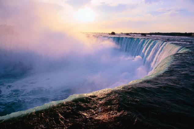
18th place. Niagara Falls USA, Canada
Niagara Falls - the common name of three waterfalls on the Niagara River, which separates the US state of New York from Canadian province of Ontario. Niagara Falls - a waterfall "Horseshoe" (eng. Horseshoe Falls), sometimes also called the Canadian Falls (Eng. Canadian Falls), the American Falls (Eng. American Falls) waterfall "Veil" (eng. Bridal Vail Falls). Although the vertical drop and is not very large, the waterfalls are very wide, and the volume of water passing through it Niagara Falls - the most powerful in North America.
The waterfall is 53 meters. The foot of the American Falls obscures a heap of stones, which is why its visible height is 3 times less. The width of the American Falls - 300 m waterfall "Horseshoe" - nearly 800 m. The name "Niagara" takes its name from the Iroquois word «Onguiaahra», which translated literally means "Thunder Water". The native population was Iroquois tribe Ongiara.
The roots lie in Falls Wisconsin glaciation, which ended about 10,000 years ago. North American Great Lakes and the Niagara River - is the result of the last continental ice sheet - a huge glacier, heading for the eastern neighborhood from Canada. After the ice melted, the drainage ditch from the Great Lakes has become a modern river Niagara, which could no longer flow through the old valley and formed a new channel in an altered landscape. When the newly formed river came across not susceptible to erosion of dolomite rock, this layer has become eroded much more slowly than lying on the lower level of soft shale rock and sand. As a result, the river undercut the solid layers and formed a waterfall.
In the XIX century tourism came into fashion, and by mid-century, this has become a major industry in the region. Popularity Falls among tourists has increased dramatically after the First World War in connection with the spread of traffic. Today, the beauty of this miracle of nature attracts many tourists from around the world, contributing to the prosperity of the cities located on the banks of the Falls Niagara Falls, New York, USA Niagara Falls, Ontario, Canada. The most colorful view of the falls from the Canadian coast opens. A few hundred meters downstream of Niagara thrown through "Rainbow Bridge", open to the movement of passenger cars and pedestrians between the two countries. Under a waterfall built hydroelectric power that currently produce up to 4, 4 gigawatts of electricity.
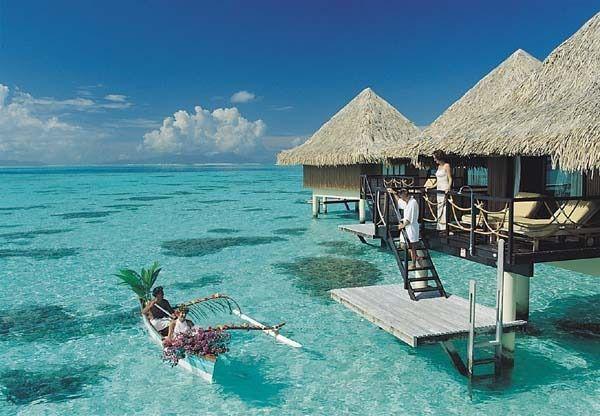
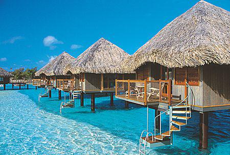
17th place. Island of Bora Bora French Polynesia, Pacific Ocean
Bora Bora - is one of the Leeward Islands archipelago Society Islands in French Polynesia in the Pacific Ocean. Bora Bora is an atoll typical of Thomas to the central mountain, surrounded by a coral reef with many motu. The central island consists mainly of basaltic lava, while motu from the wreckage of coral and sand layers. The elongated central island is 9 km long and 5 km at its widest point.
The settlements are located exclusively on the coast, while the interior covered with lush vegetation of the island inaccessible. The ring road is paved, length 32 km, encircles the island, making affordable travel between coastal settlements and hotels, while the inner part of the island in some places is only available on machines terrain. The population of Bora Bora is around 7,500 people. The largest settlement Vaitape (approximately 4000 inhabitants), located in the western part of the island, opposite the main passage into the lagoon, which is so deep that is capable of flowing even large cruise ships.
Moving in the Society Islands in the framework of the Polynesian expansion occurred relatively late. When the first wave of settlement were reached Fiji, Samoa, Tonga and the Marquesas Islands in prison, from which about 400, there was a settlement of the Society Islands. European discoverer of the island is considered to be James Cook. For the first time he landed in Bora Bora just in 1777 during his third voyage. 2 April 1786 the French explorer Louis Antoine de Bougainville reached Tahiti and declared possession of The Society Islands of France, thereby founding the modern French Polynesia. During World War II, after the Japanese attack on Pearl naval aviation Harbor on December 7, 1941, Bora Bora has become an important supply base for the United States in the South Pacific. Nevertheless, during the war, the base was never under attack, and in 1946 was disbanded. Today, Bora Bora is part of the territory of French Polynesia.
Monetary unit of French Polynesia is the Pacific franc whose value is fixed against the euro. The island's economy is based almost entirely on tourism. Bora Bora, along with Tahiti, is considered one of the most open tourist islands of the South Pacific. The island abounds with many high-end hotels, mostly frequented by American and Japanese tourists. Many hotels Class "luxury" located on Motu and offer vacationers homes located directly on stilts in the lagoon. The main attraction is the Bora Bora Lagoon, with its rich underwater world. In the depths of the lagoon inhabited by barracuda and sharks, which, under the supervision of an instructor are allowed to feed. The most famous attraction for divers is the "road rays" is a portion of the lagoon inhabited by many different species of rays. Worthy of the vision of the ruins of more than 40 marae (ceremonial sites), most of which are located in the vicinity of the village of Faanui.

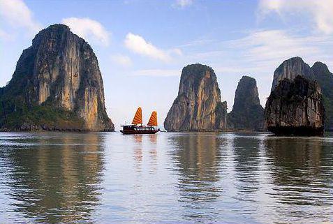
16th place. Ha Long Bay, Gulf of Tonkin, Vietnam
Ha Long - Bay of the Gulf of Tonkin Ha Long. The bay has a picturesque seaside landscape thanks scattered in shallow rocky limestone islands. Due to the inaccessible terrain, almost all the islands are uninhabited and unaffected by human influence. The exceptional aesthetics of the area combined with its biological value. The bay is located in the northeast of Vietnam, it extends from region to region Hurng Ian Van Don, its length is 120 km along the coast.
In the Gulf scattered almost two thousand limestone islands, each of which is covered with wild vegetation. Most of the islands are in its form of the tower height from 50 to 100 meters. Some of the islands are hollow, with enormous caves. The largest grotto in the bay "Hang Dau-Go" - one of the main attractions of the region. In the Gulf, there are large inhabited islands (Tuan Chau, Cat Ba), which even built hotels.
Local legend says that when the Vietnamese were fighting Chinese invaders, the gods sent to help the Vietnamese dragons. Dragons spewed from their mouths gems that turned into stone island. As a result, the island formed a wall. This saved the locals and allowed to retain their land. Dragons enjoyed on earth, and they decided to stay. That place that sank Mother of Dragons, was named Ha Long (Long translated from Vietnamese means "Dragon"), and the place that chose her children - Bai Tu Long. Ha Long Bay is considered to be the main attraction of Vietnam. And those who have never been in this place, could see it in the same series golivudskih James Bond film "Tomorrow Never Dies».
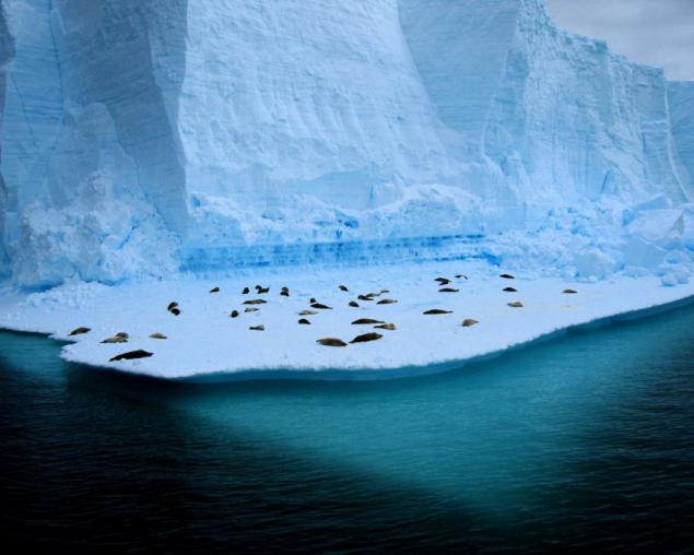
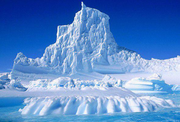
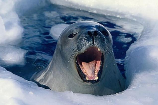
15th place. The ice of Antarctica South Pole, Antarctica
Antarctica (in Greek "the opposite of the Arctic") - the continent, located in the south of the Earth's center of Antarctica roughly coincides with the geographic south pole. The area of the continent is about 15 million km 2 (of which 1, 6 million km2 up ice shelves). Antarctica was discovered in 1820 by the Russian expedition under the leadership of Thaddeus Bellingshausen and Mikhail Lazarev.
Antarctica - the highest continent of the Earth, the average height of the surface of the continent above sea level is 2000 m, and in the center of the continent reaches 4,000 meters. Much of this is the height of the permanent ice cap of the continent, which is hidden under the continental relief and only about 5% of its ice-free areas - mostly in West Antarctica and Transantarctic Mountains: Islands, coastal areas, the so-called "Dry Valley" and some ridges and mountain peaks (nunataks) towering over the icy surface.
The Antarctic ice sheet is the largest on the planet and the closest in size exceeds the Greenland ice sheet over the area about 10 times. In it it is concentrated about 30 million square feet. km ice, i.e. 90% of all land ice. The average thickness of the ice - 2500-2800 m, reaching a maximum value in some areas of East Antarctica - up to 5 kilometers. A special feature is the large area of the Antarctic ice shelves (low "blue" area of West Antarctica) is ~ 10% of the area, towering above the sea level; These glaciers are the source of icebergs record size. In winter (summer in the northern hemisphere) sea ice area around Antarctica increases to 18 million km2, and in the summer decreases to 3-4 million km2. In accordance with the convention of the Antarctic, Antarctica does not belong to any state. Allow only scientific activity. Placement of military objects, as well as entry of warships and armed vessels to the south of the 60th degree of latitude allowed. Because of the severity of the climate in Antarctica has no permanent population. Provisional population Antarctica ranges from 4,000 to 1,000 in the summer in the winter.
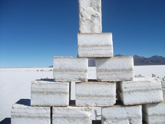
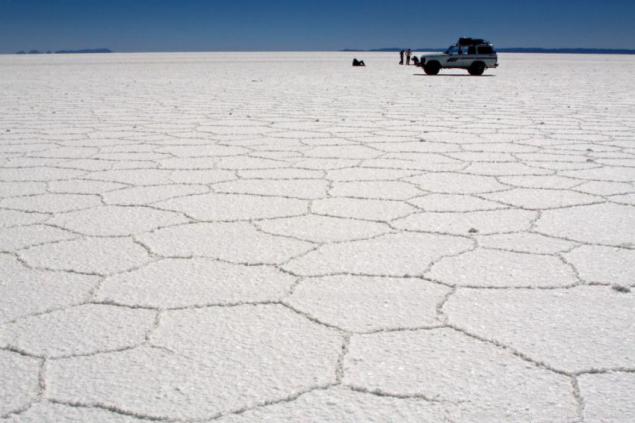
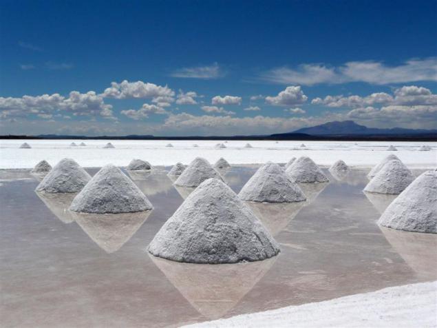
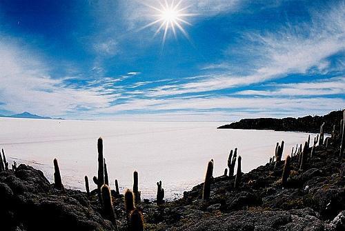
14th place. Salar de Uyuni. the plateau of the Altiplano, Bolivia
Salar de Uyuni - a dried-up salt lake in the south of the desert plains of the Altiplano in Bolivia at an altitude of 3650 meters above sea level. It has an area of over 10, 5 thousand. Km2 and is the largest saline in the world. Located near the town of Uyuni in the departments of Oruro and Potosi in the south-west of the country. The inner part of the lake is covered with a layer of salt thickness of 2-8 meters! During the rainy season it is covered with a thin layer of saline water and is transformed into the world's largest mirror.
About 40 thousand. Years ago, this area was part of Lake Minchin. After drying it remains two currently existing lakes Poopo and Uru Uru, and two major salt marsh: the Salar de Uyuni and Koypasa. According to experts, Salar de Uyuni contains a supply of 10 billion tons of salt, of which the annual production of less than 25 thous. Tons. Thanks to the development of tourism in the Salar de Uyuni, local residents began to build hotels of salt blocks, where you can stay for the night. In addition, the Salar de Uyuni is the perfect tool for testing and calibration of remote sensing satellites in the orbit. Clear skies and dry air allow Uyuni calibrate satellites five times better than if it used the surface of the ocean.
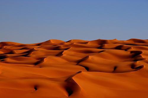
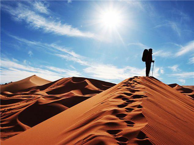
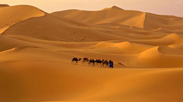
13th place. Sands Sahary.Severnaya Africa, Egypt
Sahara - the largest desert in the world, covering about 9 million km2, which is slightly smaller than that of the United States. Sahara is located in Northern Africa, in more than ten countries (Egypt, Libya, Tunisia, Algeria, Morocco, Western Sahara, Mauritania, Mali, Niger, Chad, Sudan). Sahara defies categorization within one type of the desert, although predominant sandy-rocky type.
As part of the desert a lot of regions are distinguished: Tenere, Grand Erg Oriental, Grand Erg Occidental, Tanezrouft, Hamada el-Hamra, Erg Igidi, Erg Shesh, Arabian, Libyan, Nubian Desert. The name "Sahara" - a Tuareg Arabic translation of the word "Tenere", meaning desert.
In 2008, an international team of scientists from Germany, Canada and the US The study found that the Sahara became a desert 2,700 years ago by the very slow evolution of the climate. Such conclusions scientists were able to make based on the study of geological sediments dredged from the lake Joa, located in northern Chad. According to studies, about 6 thousand. Years ago in the Sahara were trees and had a lot of lakes. Thus, the work of scientists refutes the existing theory of the transformation of this part of Africa, in the desert 5, 5 thousand. Years ago and that the desertification process took only a few centuries. In the Sahara, every year there is about 160 thousand. Mirages. They are stable and wandering, vertical and horizontal. Compiled even special cards caravan routes to the assessment of places usually seen mirages. These maps marked where there wells, oases, palm groves, mountain ranges.
12th. Angkor Siem Reap, Cambodia
Angkor - metropolitan area of the Khmer Empire IX-XV centuries., To dominate the whole of Southeast Asia, which has Angkor Wat and Angkor Thom - an outstanding monument of medieval art Rouge. Angkor stretched for 24 km from east to west and 8 km from north to south. It is located on the banks of the Tonle Sap lake about 240 kilometers north-west of the capital Phnom Penh, Cambodia.
Construction of this grand temple complex lasted for four centuries.
The name of this fjord is translated as "bright fjord". This is explained by the fact that the coast is framed by bright granite skaly.Zaliv stretches for 42 kilometers, and its maximum depth is 420 m. The Lysefjord is known for its wildness and inaccessibility of majestic cliffs, from the tops of which offer incredible views

Sognefjord
It is the largest fjord in Europe and the second largest in the world, second only to Scoresby in Greenland. The length of the Sognefjord is 204 km, and in some places you can get to the bottom at a depth of only 1,308 meters.

Hardanger Fjord is the third largest fjord in the world. In this region of Norway milder climate. This fjord is remarkable in that its shores are divided orchards. Nevertheless, even in summer you can ski on the glaciers of the Hardanger Fjord. Hardangervidda - a favorite summer pasture of wild reindeer.

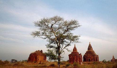
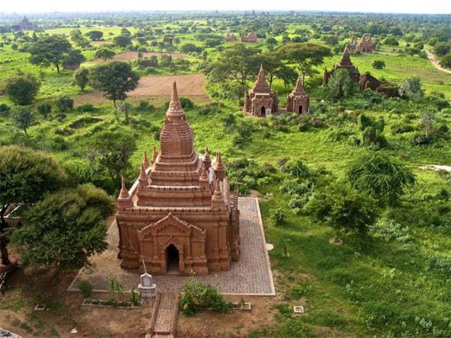
19th place. Pagan Magway Region, Myanmar (Burma)
Pagan (Bagan or) - the ancient capital of the eponymous kingdom in what is now Myanmar. The city is located on a dry plateau along the west bank of the Irrawaddy River, southeast of Mandalay, near the town of Chowk in Magway District. Currently, the site of the ancient city is the archaeological zone with thousands of pagodas, temples, stupas and monasteries. Pagan ruins cover an area of about 40 km2.
Most buildings were built during the XI-XIII centuries, when Bagan was the capital of dynastic kingdoms. King Pinbya at the end of IX century, suffered in the capital of Bagan. However, transferring the capital to the Burmese history occurred often, and in the XI century Anoratha king moved the capital to another city. Anoratha Pagan decided to turn into a cultural center. It approved the teaching of Theravada Buddhism as the state religion and spiritual mission sent to Sri Lanka, where the monks came and helped him complete treatment of the whole country in the Theravada. Bagan became the center of science, religion and culture, one of the largest cities in the world. At the end of the XIII century the kingdom was occupied by the Mongols. The city has been looted, stripped off the gold pagodas, numerous religious relics were stolen.
City Bagan as such does not exist - there are only Bagan airport, and several villages (Nyaung U, Be-chih Ying Minkaba, Old Bagan) around and within the huge archaeological area with scattered thousands of large and small stupas and pagodas. The most important stupa - like Shvezigon and Lokananda Chown, keeping the teeth of the Buddha - gold-plated, approaches to them are paved, and around built many pavilions. Most pagodas were built of red brick and white stone and covered with gold. Less significant pagodas are also protected and restored. The removal is a lot of very small stupas and pagodas, some of them destroyed. Location between the temples - scorched desert, in some places - standing alone palm places - green thickets.
Usually temples symmetrical shape with four altars and statues of Buddha in each direction of the horizon. There is also a more than 700 stupas with the holy relics. Interesting and cave "Gubyauchzhi" - a maze of corridors to the temples, painted frescos. The older two-tone murals, frescoes later monochromatic, and images are often fantastic and surreal. This place is very popular among tourists, as there may be more than one day to go from temple to temple, meditating before the altar to climb on top of the tiers of the steep steps and through the internal stairs dark, watch the sunset from special viewing platforms on the tops of temples. Despite the obvious cultural and historical significance, UNESCO failed to declare Pagan world heritage for political reasons.


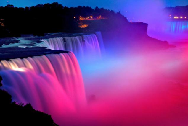
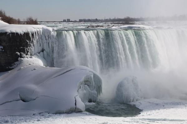
18th place. Niagara Falls USA, Canada
Niagara Falls - the common name of three waterfalls on the Niagara River, which separates the US state of New York from Canadian province of Ontario. Niagara Falls - a waterfall "Horseshoe" (eng. Horseshoe Falls), sometimes also called the Canadian Falls (Eng. Canadian Falls), the American Falls (Eng. American Falls) waterfall "Veil" (eng. Bridal Vail Falls). Although the vertical drop and is not very large, the waterfalls are very wide, and the volume of water passing through it Niagara Falls - the most powerful in North America.
The waterfall is 53 meters. The foot of the American Falls obscures a heap of stones, which is why its visible height is 3 times less. The width of the American Falls - 300 m waterfall "Horseshoe" - nearly 800 m. The name "Niagara" takes its name from the Iroquois word «Onguiaahra», which translated literally means "Thunder Water". The native population was Iroquois tribe Ongiara.
The roots lie in Falls Wisconsin glaciation, which ended about 10,000 years ago. North American Great Lakes and the Niagara River - is the result of the last continental ice sheet - a huge glacier, heading for the eastern neighborhood from Canada. After the ice melted, the drainage ditch from the Great Lakes has become a modern river Niagara, which could no longer flow through the old valley and formed a new channel in an altered landscape. When the newly formed river came across not susceptible to erosion of dolomite rock, this layer has become eroded much more slowly than lying on the lower level of soft shale rock and sand. As a result, the river undercut the solid layers and formed a waterfall.
In the XIX century tourism came into fashion, and by mid-century, this has become a major industry in the region. Popularity Falls among tourists has increased dramatically after the First World War in connection with the spread of traffic. Today, the beauty of this miracle of nature attracts many tourists from around the world, contributing to the prosperity of the cities located on the banks of the Falls Niagara Falls, New York, USA Niagara Falls, Ontario, Canada. The most colorful view of the falls from the Canadian coast opens. A few hundred meters downstream of Niagara thrown through "Rainbow Bridge", open to the movement of passenger cars and pedestrians between the two countries. Under a waterfall built hydroelectric power that currently produce up to 4, 4 gigawatts of electricity.


17th place. Island of Bora Bora French Polynesia, Pacific Ocean
Bora Bora - is one of the Leeward Islands archipelago Society Islands in French Polynesia in the Pacific Ocean. Bora Bora is an atoll typical of Thomas to the central mountain, surrounded by a coral reef with many motu. The central island consists mainly of basaltic lava, while motu from the wreckage of coral and sand layers. The elongated central island is 9 km long and 5 km at its widest point.
The settlements are located exclusively on the coast, while the interior covered with lush vegetation of the island inaccessible. The ring road is paved, length 32 km, encircles the island, making affordable travel between coastal settlements and hotels, while the inner part of the island in some places is only available on machines terrain. The population of Bora Bora is around 7,500 people. The largest settlement Vaitape (approximately 4000 inhabitants), located in the western part of the island, opposite the main passage into the lagoon, which is so deep that is capable of flowing even large cruise ships.
Moving in the Society Islands in the framework of the Polynesian expansion occurred relatively late. When the first wave of settlement were reached Fiji, Samoa, Tonga and the Marquesas Islands in prison, from which about 400, there was a settlement of the Society Islands. European discoverer of the island is considered to be James Cook. For the first time he landed in Bora Bora just in 1777 during his third voyage. 2 April 1786 the French explorer Louis Antoine de Bougainville reached Tahiti and declared possession of The Society Islands of France, thereby founding the modern French Polynesia. During World War II, after the Japanese attack on Pearl naval aviation Harbor on December 7, 1941, Bora Bora has become an important supply base for the United States in the South Pacific. Nevertheless, during the war, the base was never under attack, and in 1946 was disbanded. Today, Bora Bora is part of the territory of French Polynesia.
Monetary unit of French Polynesia is the Pacific franc whose value is fixed against the euro. The island's economy is based almost entirely on tourism. Bora Bora, along with Tahiti, is considered one of the most open tourist islands of the South Pacific. The island abounds with many high-end hotels, mostly frequented by American and Japanese tourists. Many hotels Class "luxury" located on Motu and offer vacationers homes located directly on stilts in the lagoon. The main attraction is the Bora Bora Lagoon, with its rich underwater world. In the depths of the lagoon inhabited by barracuda and sharks, which, under the supervision of an instructor are allowed to feed. The most famous attraction for divers is the "road rays" is a portion of the lagoon inhabited by many different species of rays. Worthy of the vision of the ruins of more than 40 marae (ceremonial sites), most of which are located in the vicinity of the village of Faanui.


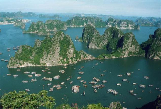
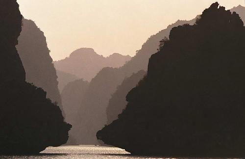
16th place. Ha Long Bay, Gulf of Tonkin, Vietnam
Ha Long - Bay of the Gulf of Tonkin Ha Long. The bay has a picturesque seaside landscape thanks scattered in shallow rocky limestone islands. Due to the inaccessible terrain, almost all the islands are uninhabited and unaffected by human influence. The exceptional aesthetics of the area combined with its biological value. The bay is located in the northeast of Vietnam, it extends from region to region Hurng Ian Van Don, its length is 120 km along the coast.
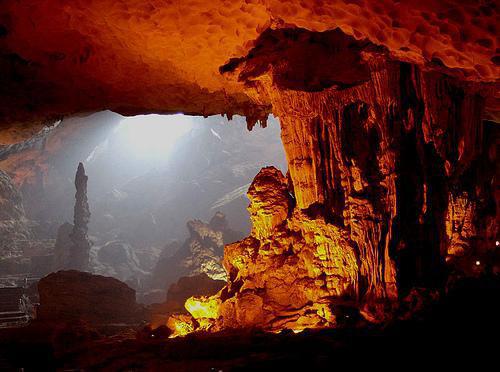
In the Gulf scattered almost two thousand limestone islands, each of which is covered with wild vegetation. Most of the islands are in its form of the tower height from 50 to 100 meters. Some of the islands are hollow, with enormous caves. The largest grotto in the bay "Hang Dau-Go" - one of the main attractions of the region. In the Gulf, there are large inhabited islands (Tuan Chau, Cat Ba), which even built hotels.
Local legend says that when the Vietnamese were fighting Chinese invaders, the gods sent to help the Vietnamese dragons. Dragons spewed from their mouths gems that turned into stone island. As a result, the island formed a wall. This saved the locals and allowed to retain their land. Dragons enjoyed on earth, and they decided to stay. That place that sank Mother of Dragons, was named Ha Long (Long translated from Vietnamese means "Dragon"), and the place that chose her children - Bai Tu Long. Ha Long Bay is considered to be the main attraction of Vietnam. And those who have never been in this place, could see it in the same series golivudskih James Bond film "Tomorrow Never Dies».


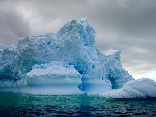
15th place. The ice of Antarctica South Pole, Antarctica
Antarctica (in Greek "the opposite of the Arctic") - the continent, located in the south of the Earth's center of Antarctica roughly coincides with the geographic south pole. The area of the continent is about 15 million km 2 (of which 1, 6 million km2 up ice shelves). Antarctica was discovered in 1820 by the Russian expedition under the leadership of Thaddeus Bellingshausen and Mikhail Lazarev.
Antarctica - the highest continent of the Earth, the average height of the surface of the continent above sea level is 2000 m, and in the center of the continent reaches 4,000 meters. Much of this is the height of the permanent ice cap of the continent, which is hidden under the continental relief and only about 5% of its ice-free areas - mostly in West Antarctica and Transantarctic Mountains: Islands, coastal areas, the so-called "Dry Valley" and some ridges and mountain peaks (nunataks) towering over the icy surface.
The Antarctic ice sheet is the largest on the planet and the closest in size exceeds the Greenland ice sheet over the area about 10 times. In it it is concentrated about 30 million square feet. km ice, i.e. 90% of all land ice. The average thickness of the ice - 2500-2800 m, reaching a maximum value in some areas of East Antarctica - up to 5 kilometers. A special feature is the large area of the Antarctic ice shelves (low "blue" area of West Antarctica) is ~ 10% of the area, towering above the sea level; These glaciers are the source of icebergs record size. In winter (summer in the northern hemisphere) sea ice area around Antarctica increases to 18 million km2, and in the summer decreases to 3-4 million km2. In accordance with the convention of the Antarctic, Antarctica does not belong to any state. Allow only scientific activity. Placement of military objects, as well as entry of warships and armed vessels to the south of the 60th degree of latitude allowed. Because of the severity of the climate in Antarctica has no permanent population. Provisional population Antarctica ranges from 4,000 to 1,000 in the summer in the winter.


14th place. Salar de Uyuni. the plateau of the Altiplano, Bolivia
Salar de Uyuni - a dried-up salt lake in the south of the desert plains of the Altiplano in Bolivia at an altitude of 3650 meters above sea level. It has an area of over 10, 5 thousand. Km2 and is the largest saline in the world. Located near the town of Uyuni in the departments of Oruro and Potosi in the south-west of the country. The inner part of the lake is covered with a layer of salt thickness of 2-8 meters! During the rainy season it is covered with a thin layer of saline water and is transformed into the world's largest mirror.
About 40 thousand. Years ago, this area was part of Lake Minchin. After drying it remains two currently existing lakes Poopo and Uru Uru, and two major salt marsh: the Salar de Uyuni and Koypasa. According to experts, Salar de Uyuni contains a supply of 10 billion tons of salt, of which the annual production of less than 25 thous. Tons. Thanks to the development of tourism in the Salar de Uyuni, local residents began to build hotels of salt blocks, where you can stay for the night. In addition, the Salar de Uyuni is the perfect tool for testing and calibration of remote sensing satellites in the orbit. Clear skies and dry air allow Uyuni calibrate satellites five times better than if it used the surface of the ocean.


13th place. Sands Sahary.Severnaya Africa, Egypt
Sahara - the largest desert in the world, covering about 9 million km2, which is slightly smaller than that of the United States. Sahara is located in Northern Africa, in more than ten countries (Egypt, Libya, Tunisia, Algeria, Morocco, Western Sahara, Mauritania, Mali, Niger, Chad, Sudan). Sahara defies categorization within one type of the desert, although predominant sandy-rocky type.
As part of the desert a lot of regions are distinguished: Tenere, Grand Erg Oriental, Grand Erg Occidental, Tanezrouft, Hamada el-Hamra, Erg Igidi, Erg Shesh, Arabian, Libyan, Nubian Desert. The name "Sahara" - a Tuareg Arabic translation of the word "Tenere", meaning desert.
In 2008, an international team of scientists from Germany, Canada and the US The study found that the Sahara became a desert 2,700 years ago by the very slow evolution of the climate. Such conclusions scientists were able to make based on the study of geological sediments dredged from the lake Joa, located in northern Chad. According to studies, about 6 thousand. Years ago in the Sahara were trees and had a lot of lakes. Thus, the work of scientists refutes the existing theory of the transformation of this part of Africa, in the desert 5, 5 thousand. Years ago and that the desertification process took only a few centuries. In the Sahara, every year there is about 160 thousand. Mirages. They are stable and wandering, vertical and horizontal. Compiled even special cards caravan routes to the assessment of places usually seen mirages. These maps marked where there wells, oases, palm groves, mountain ranges.


12th. Angkor Siem Reap, Cambodia
Angkor - metropolitan area of the Khmer Empire IX-XV centuries., To dominate the whole of Southeast Asia, which has Angkor Wat and Angkor Thom - an outstanding monument of medieval art Rouge. Angkor stretched for 24 km from east to west and 8 km from north to south. It is located on the banks of the Tonle Sap lake about 240 kilometers north-west of the capital Phnom Penh, Cambodia.
Construction of this grand temple complex lasted for four centuries.