Beautiful Russian roads
 Bashny.Net
Roads that choose us,
Roads that are laughing in our faces.
Roads, road - without lumen and edges.
One Way - the Milky Way,
Another - tram ring.
© Zimove animals
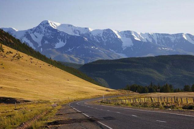
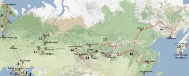
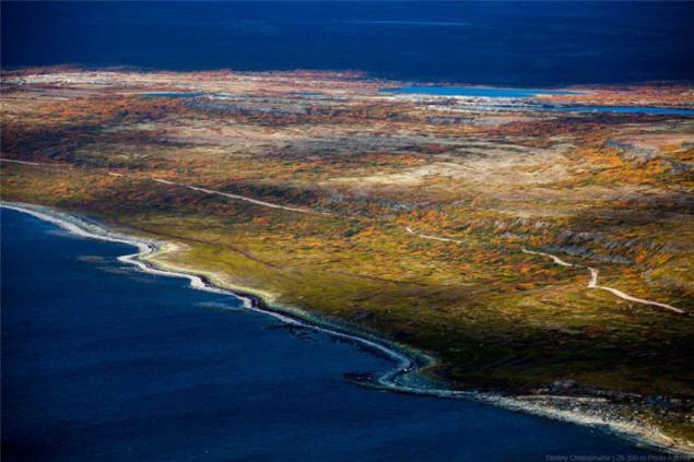
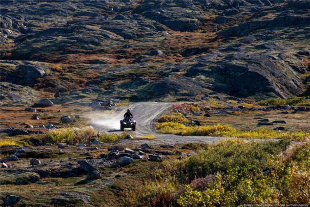
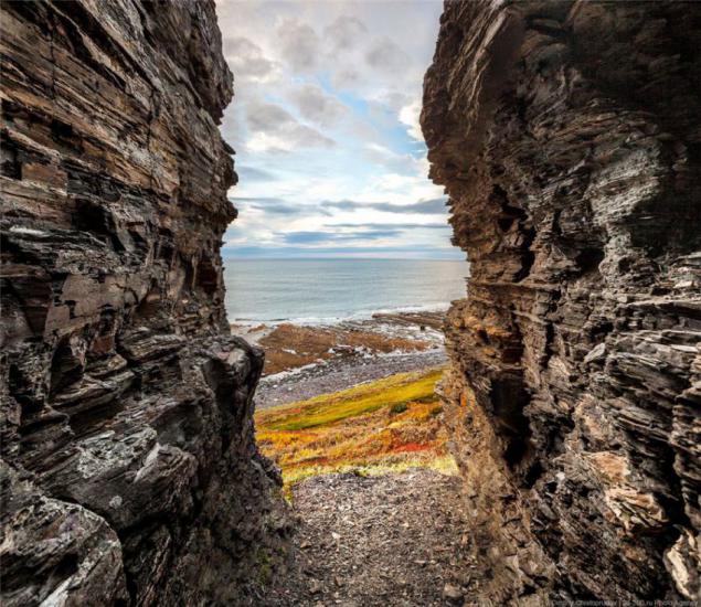
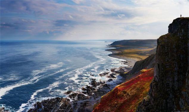
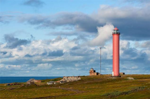
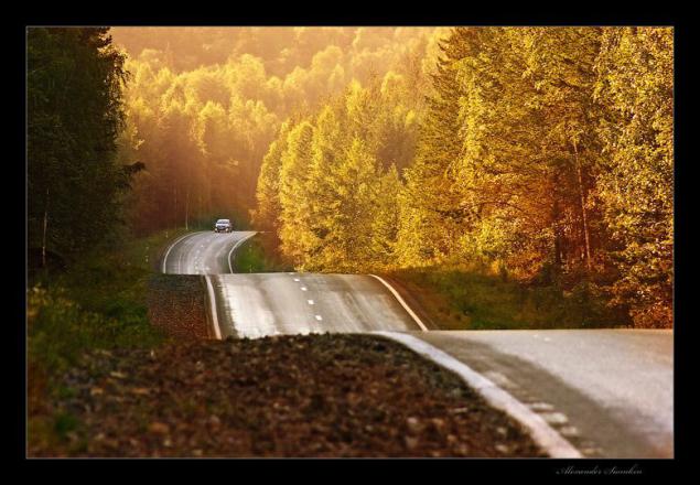
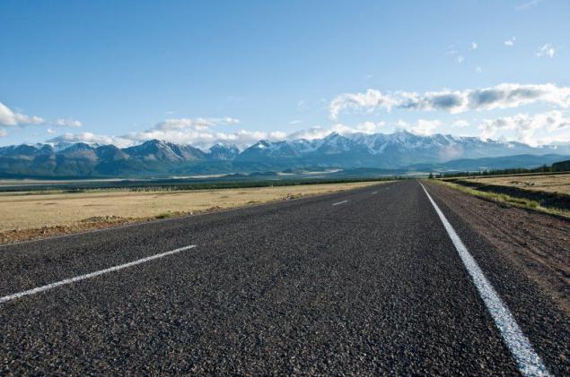
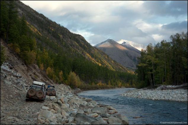
1. Lighthouse on the peninsula fish. Route M18 "Kola" from Kemi to the border with Norway
The track is beautiful, and the farther to the north of the Arctic Circle, the more beautiful. Here and streamers, and passes, and Karelian pine with lakes and hills, and swamps ... Asphalt summer 2013th was excellent, but in a couple of places across areas of repair.
But the most beautiful places you will see, only turning to the federal highway.
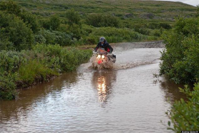
Vaydagubsky lighthouse on the peninsula Fishermen - a symbolic place for many motoputeshestvennikov. Get to the northernmost point of the European part of Russia sought by many. Local told that in a fishing season and the middle part of going natural mototuristov camp. Roads are bad, so people mostly ride on Enduro and turyndah, but some comrades crawl to fish on maksiskuterah / Drazdy / Hayabusa.
Beach Peninsula Middle and Small Volokovaya lip.
Roads Peninsula Middle
Brody Middle.
Vaydagubsky lighthouse at Cape German
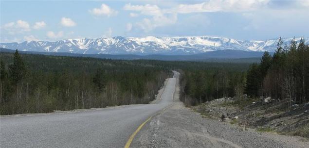
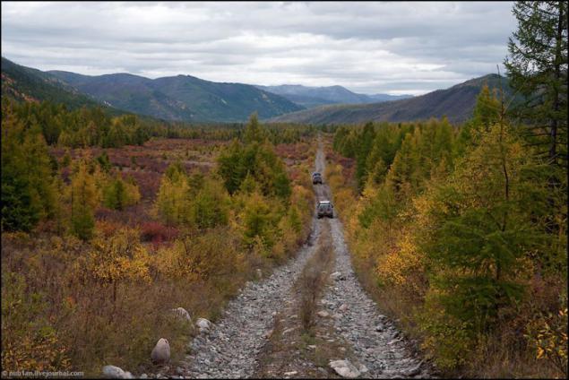
2. Khibiny Mountains, Kola Peninsula. The road over the pass Kukisvumchorr.
Khibiny Mountains - the heart of the Kola Peninsula. Understated beauty of the North attracts me a lot more comfort hot southern resorts. This is a land of mountains with flat tops and steep slopes, turquoise lakes and rapid rivers, the harsh northern edge of the forest and endless tundra ...
To the foot of the mountains is pitted asphalt pits otvorotka the track "Cola».
Bridge over the Strait Ekostrovsky
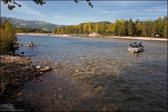
But the most interesting - as always, where there is no asphalt =) From south to north, through the pass Kukisvumchorr, Khibiny Mountains crosses the primer.
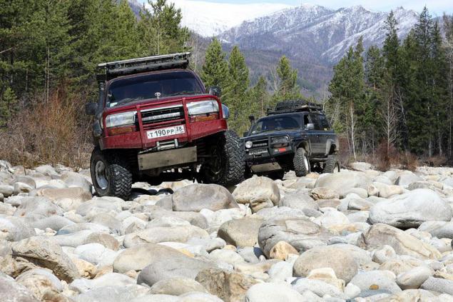
The most picturesque part of this primer is on the riverbed Kukisyok. Shallow river flowing nearby, and even on the road. Rocky bottom, and with a strong desire can be reached even on road builders:
3. Karelia. Road Питер-Сортавала-Поросозеро-Костомукша-Калевала-Паанаярви
"Firs-pine-trees-pine ... on, girls! ... Lakes!»
On the roads of the country of thousand lakes are many areas of soil with "closed" turns and changes in elevation and simply slides to the lack of visibility of oncoming traffic. But all these inconveniences completely compensated vistas of forest and thicket lake.
Pongoguba, near the A135
The road to the National Park "Paanajarvi»
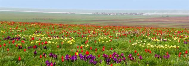
4. Blooming prairie spring, Kalmykia. Road "Volgograd - Elista - Stavropol».
In Kalmykia, the roads are good, apparently, part of the repair effect is positive, but the first 50-60 km of track in the Volgograd region awful - bumps, potholes, the road is divided into the trash. But to go down this road should not for checking the quality of asphalt. In the spring (late April - early May) before the eyes of travelers opens blooming steppe.
It is said that the one who podgadat the trip and fall on flowering tulips, view bright red steppe remembered for a lifetime. In these days of wild steppe suddenly erupts fabulous multi-colored carpet and filled with magical aroma of millions of blooming tulips and a clear steppe air thunders from sonorous and polyphonic orchestra of hundreds of large Melanocorypha - dzhurbaev.
Tulip field near the lake. Manych, near Elista
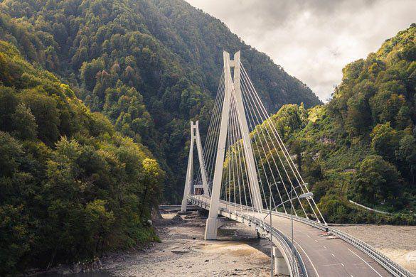
5. Southern serpentines and the Black Sea, Western Caucasus. Route M27 "Anapa - Adler».
The road from Anapa to Sochi is one of the most beautiful in our country: the endless switchbacks, mountains, fields, vineyards, sea and other landscapes of the Krasnodar Territory. The most beautiful and most difficult leg of the route on the distance from Dzhubga to Dagomys. There's a lot of cool closed turns, as well as periodic landslides.
Summer on the highway M-27 full of cars, traffic jams are often due to accidents and pedestrians in the resort town. Therefore, KMK, the best ride on the south in the Indian summer, when the main crowd of tourists have gone home.
Freshly built cable-stayed bridge on the road "Adler - Alpika Service»
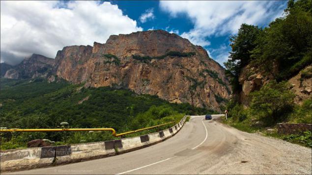
6. North Caucasus, Karachai-Cherkessia. Sukhumi Military Road (A155, the plot of "Circassian - Dombay»).
Through the Main Caucasian Ridge historically existed three key roads: Sukhumi Military, Military-Ossetian and Georgian Military. Sukhumi Military Road from Cherkessk to Sukhum was considered the most beautiful of them all. Unfortunately, now it will not work on it to reach Sukhumi. For 7 km to Dombey, immediately after turning on Gonachhirskoe gorge worth PPC Teberdinsky reserve. Mot have to leave the parking lot in front of a cordon and crawl up the pass Klukhori walk on flat asphalt (!) Road. The pass itself became almost impassable even for pedestrians due to landslides and washouts. And pograntsy not asleep, the Russian border with Abkhazia as in any way.
But it is possible to turn in Dombay and walk along the famous ski resort. From Cherkessk to Dombaya asphalt is almost perfect.
Mountains near Dombai
7. North Caucasus, Karachai-Cherkessia. Route A157 "Min. water - Karachaevsk ».
Route A157 "Min. water - Karachaevsk "attractive two things: Pass Gum-Bashi and views of Mount Elbrus.

View on Elbrus pass Gum-Bashi
8. Elbrus, Kabardino-Balkaria. Route A158 "Baksan - Elbrus».
A158 scenic route "Baksan - Elbrus" runs through the valley and Kabardinsky territory of the Greater Caucasus mountain range.
The road to Mount Elbrus
Paved trail runs along a narrow Baksan Gorge and rises to two and a half thousand meters, almost to the very volcano Elbrus. This is the most mountainous road of all roads in the five canyons of Kabardino-Balkaria and the most decent track in the country, not counting federal. It is replete with steep ascents and descents and unexpected turns.
River Baskan accompanies the traveler all over the road, noise, rolls on numerous rapids, turning over huge boulders. It is not something that swim - even cross almost unreal.
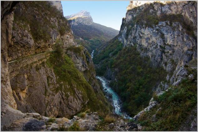
9. North Caucasus, Kabardino-Balkaria. Road R291 "Urvan - Cherek Gorge - Upper Balkaria».
The road through the gorge Cherek - perhaps one of the most spectacular roads in the Caucasus.
When the gorge narrows to 40 meters road hides in a modern tunnel. And the old footpath still winds along the cliff.
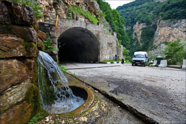
Old road around the rock. No fences, climbing shoes height of about 500 meters, the noise of Cherek.
10. Northern Urals. Serov tract.
Serov path goes from Ekaterinburg to the north, the city of Serov, through thickly forested Ural mountains, rivers and swamps. First hundred kilometers (almost to Nizhny Tagil) tract is divided into two separate one-way road, two or three lanes each. And in some places the roads are divided by mountains and forest. And under Tagil they merge into one narrow, but good on the trails. Almost too good: because of the high accident rate lovers anneal / overtake on an opposite it is called "the road of death." Local GIBDDshniki instead of expanding the road invited the priest to bless the track, but for some reason this did not help.
Serov tract isolation EKAD, Sverdlovsk region
500 km from E-burg, Serov tract
And Serov tract original hang banners:
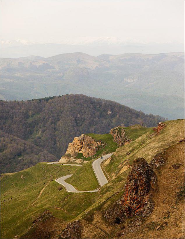
11. Southern Urals. The track "Ufa - Beloretsk».
Decoration highway "Ufa - Beloretsk" is a serpentine through the Ural Mountains. Bribes and that the cars on the road is very small. But it is marvelous stud "Teschin language" about half-way to Beloretsk. Beneath her lying skeletons passenger cars many years ago, and even semi-long-length.
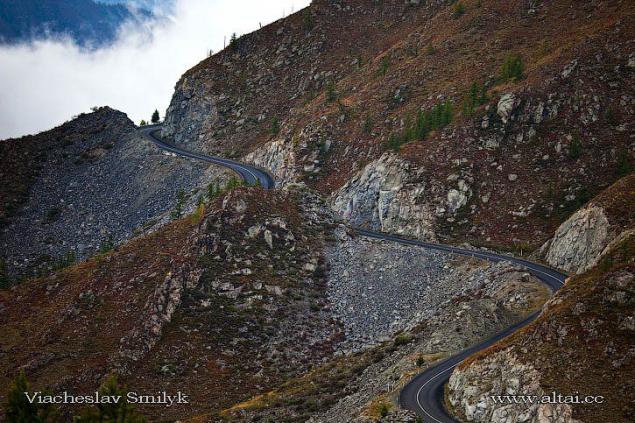
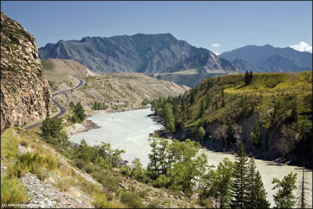
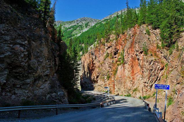
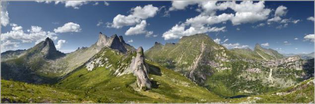
12. Altai Mountains. Chuiski (M52).
It is this way is often called "the most beautiful roads of Russia." And no wonder, because the landscapes of the Altai Mountains are very diverse and stagger the imagination.
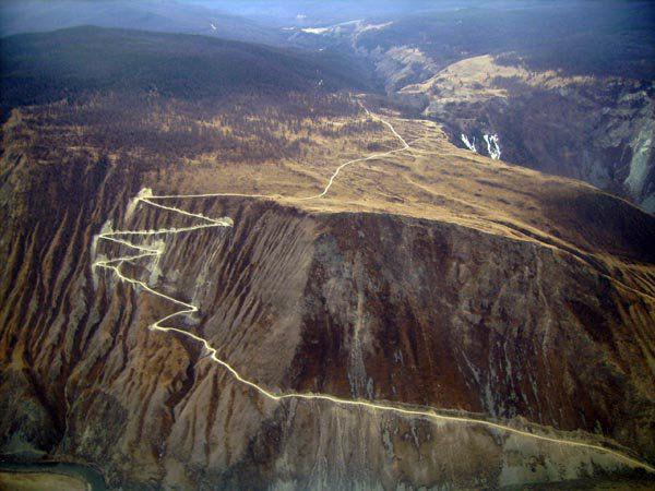
659 km Chui tract is a pointer "Start ascent to Chike-Taman." The road zigzags beautiful escapes upwards. In earlier times, until 1984, the pass was difficult and dangerous obstacle because of its narrowness, steepness and sharp climb. But after the next exacerbation of Russian-Chinese relations turned out that on the strategically important artery of our missiles just will not go to a meeting with the enemy because of his size. Therefore urgently organized a new road wider. But also old can ride!
Chike Taman
uschestvuyuschaya today the road passes close to the old Chu tract. Prior to the beginning of the XX century by Chike-Taman led equestrian trail with 34 twists and turns dangerous when lifting. It was a terrible way. This is how her contemporaries:
Chike-Taman. First of all, saying, scrawled on a roadside pole, at the top of the pass, the hand of a desperate coachman: "ETA is not Chike-Taman, and Hell-Ataman, forty-eight of sins." In ztom says it all, poured all the bile narugavshegosya utterly human, tortured himself and ruin here, maybe more than one horse.
Chike-Taman - a huge mountain range, block the way to the valley Ulegema, which goes tract. You are approaching close to the mountain, get out of the wagon and on foot climb the endless convolutions tract. A horse in the meantime toil over your crew. You went up to one hundred and sixty fathoms, and at the same rate should go down. A horizontal distance between the two extreme points of ascent and descent - only one outlet. All these separate path zigzags short and narrow radius of curvature is small, large deviations.
Rounded to the cart may not be able to turn around: the wheels hanging over the abyss nothing fenced. Another awkward step horse, and she, along with a load of slips down.
From the observation deck of modern roads are being overrun seen this way.
In the south Chuiski passes through dry steppe Chui, a kind of border zone between the Altai and Kazakh settlements. There is already felt the impact of dry Mongolia. Chu steppe landscapes of deserts and affect its severity not seen any trees or bushes or buildings. Around a cracked earth and plain islands wormwood and thorns. It is very clearly felt the scale of this world - expanses of steppe, the grandeur of the mountains, the height of the sky ...
13. Altai Mountains. Road "Gorno-Altaisk - Lake Teletskoye - Pass Katu-Yaryk" and Ulagansky tract
Teletskoye lake - Baikal in miniature, one of the most beautiful and deepest lakes in Russia. The lake water is so transparent that the bottom can be seen at 15 meters deep, and so cold that you risk becoming a frozen cake mix with reckless bathing in the "gentle" waters. The easiest way to get to it, turned off the Chui tract to Gorno-Altaisk, and then drive another 150 km to the village Iogach. From north to south lake, you can swim on the ferry.
The road from the lake to the pass goes through the valley of the river Chulyshman.
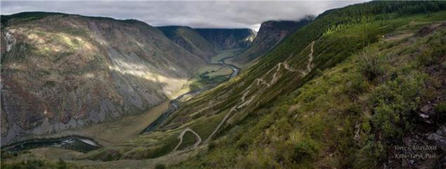
After overcoming the pass you can return to the M-52 on Ulagansky path through the sacred Ulagansky pass.
"Red Gate" Ulagan tract
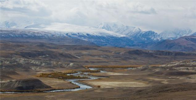
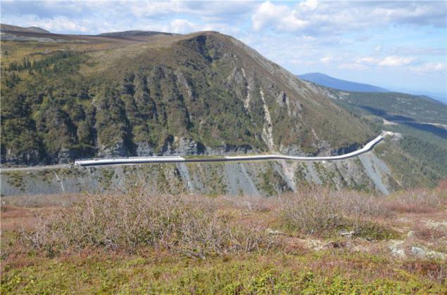
14. Sayan, Khakassia. Usinsky tract ("Abakan - Kyzyl", M54)
Federal Highway "Yenisei" is a logical continuation of the historical Usinskoye tract connecting the capital of Khakassia first Usinskaya the village, then Kyzyl, and today, and with Mongolia. Altai Mountains is a little touched by civilization: there there are paved roads, large villages, camp sites and even climbing camp. Sayan is a central part of its pristine wild, do not know spokon century housing, wheel, ax, not to mention the economic development.
The path crosses the Western Sayan from start to finish. 80% of the territory of the Republic of Tuva is covered by mountains - the Western Sayan and Altai foothills in the south-west. Mezhgryadnye same basin are not worse than the Kalmyk steppe. All together looks absolutely amazing!

Road to the vast majority of its extent is quite decent coverage. Izdyryavlen only a portion of one of the passes, rather dangerous-looking. Despite the small busy road, columns in memory of crashed there are everywhere. No wonder: the profile of the road is unlikely to add to our human instinct of self-preservation. Do not slow down in this corner - do not fly away in a ditch, and in the valleys between the mountains.
Avalanche gallery at Usinskoye tract, which locals call the "Shelf". They say its winter covered with snow up to the top.
Sayan.
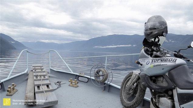
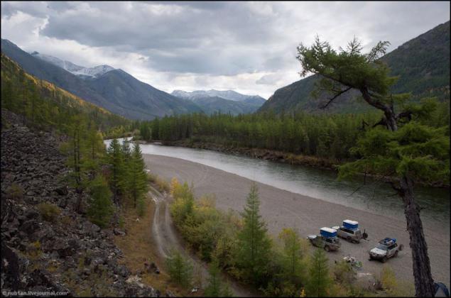
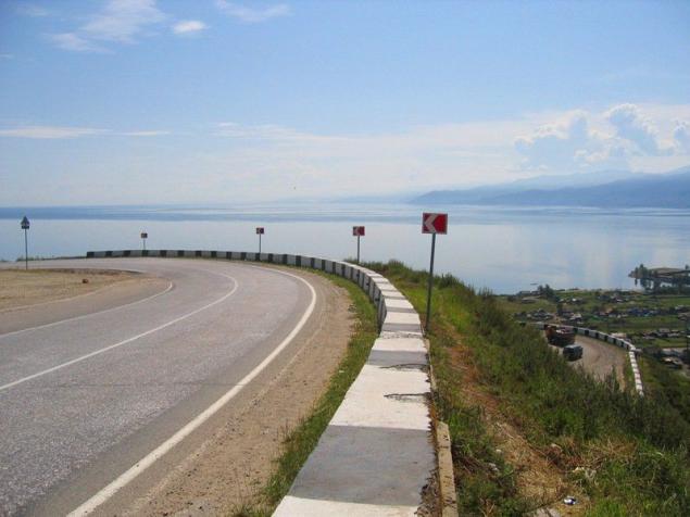
15. Around the Lake Baikal. The track "Viluy" - BAM - 110y winter road "New Uoyan - Ulyunhan" - Barguzinsky tract - M55 "Baikal" - Kultuk tract.
Roads around Lake Baikal little more direction. Quite tolerable federal highway "Viluy" comes from Tulun to Ust-Kut. It is here that terminate routes truckers and broken gravel road begins with burned bridges, running along the BAM to Severobaykalsk.
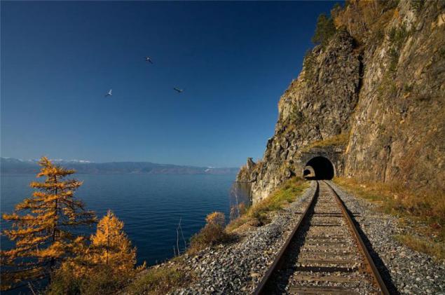
In Severobaykalsk road around the lake finally comes ashore lake and winds through it past the picturesque "capes tunnels" Circum-Baikal railway to Nizhneangarsk.
Because of the unusually warm winter 74go year road on the ice of Lake Baikal became neproezzhabelnoy, and BAM left without supplies. I had to quickly organize temporary land road to transport goods, connecting the mainland and the "construction of the century." In the winter, the route goes up to 80 trucks per day. Even then, the road was not easy, so along it runs through some warm beam put to rest and repair.
After the construction of BAM road became unnecessary. For a while it was used as a winter road, but the destruction of the bridges over the Barguzin difficult to move permanently.
Gradually, the road turned into the direction and became overgrown with legends. The route through the winter road chosen dzhipery, cycling and mototuristy. According to the sole survivor kilometer post with it called "110-th winter road».
Route around the lake is complex, but very beautiful. Quiet and unobtrusive northern taiga, tundra expansion, rapids of mountain rivers, ice, mountain passes, snow-capped peaks, rocky and forested peaks on the horizon. No cars - no counter or passing. Bears, caribou, deer, wood grouse, moose. Wood lives his life, and he does not care about human vanity.
Serpentine Kultuk tract
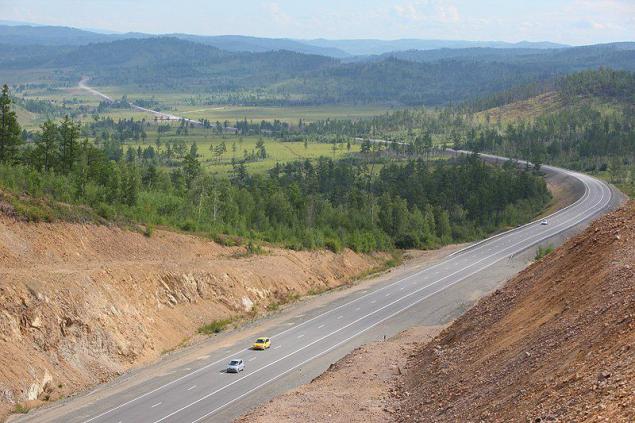
16. Siberia. Highway "Amur»
According to the magazine "At the wheel" highway "Amur" is on the 10th place in the list of the most interesting and beautiful roads in the world. Apparently, the journalist turned patriot or a lover of forests =) Never saw Russian road in such lists.
What cost to travel 6,000 km from Moscow? That's how much separates the capital from Chita, where begins the track "Cupid." The ancient merchant city was once a Russian trading outpost on the border with China. Now it starts from the most beautiful track in Russia. It is unique in every way. Firstly, it is one of the most modern roads in the country - it meets all international standards (for Russia it is very rare). Second, the road runs through the fantastically beautiful and almost untouched places - Transbaikalia and the Far East.
On both sides of the highway surrounded the taiga, and kept popping up on the highway deer and other animals. The route winds its way between the picturesque hills, the soaring upward, then down to the lowlands, and not a soul around ... Only here you know what our vast country, from one locality to another is 50-100 km, and between them - pristine Siberia.
18. Magadan. The track "Lena" (M56 "route Amur - Yakutsk") and Kolyma tract (P504 "Yakutsk - Magadan»).
- Well, we're on the Kolyma - welcome!
- No, it's better you to us!
© k / f "The Diamond Arm»
In 2006, the federal highway "Lena" was in first place in the top ten most terrible roads in the world. This road is almost blurred after every heavy rain. Steep passes, abandoned areas, blurred rains, rivers without bridges, dead, decaying villages, extremely harsh climate make the ride on the highway close to the extreme.
Photos track "Lena" from this famous series
But despite all this, why people are drawn to wild places? Let me quote Ivan odynokiy:
Since the early '90s track depopulated. Gold mines were closed, and the lack of work has forced people to throw so hard to relocate. Today the road is empty. Can be for several days did not see any oncoming traffic. Drivers megacities curse cork probably hard to imagine that there are other extreme, to which is also difficult to get used to. Any serious accident or breakdown - fraught, especially in winter.
But on the track soars elusive spirit of freedom, liberty and fraternity, which put in a makeshift sign "End of all restrictions." The track never knew what the traffic police. Here it is hello, all against all. Here any fire poured thick as chifir, tea. where are you from?
Roads that are laughing in our faces.
Roads, road - without lumen and edges.
One Way - the Milky Way,
Another - tram ring.
© Zimove animals


1. Lighthouse on the peninsula fish. Route M18 "Kola" from Kemi to the border with Norway
The track is beautiful, and the farther to the north of the Arctic Circle, the more beautiful. Here and streamers, and passes, and Karelian pine with lakes and hills, and swamps ... Asphalt summer 2013th was excellent, but in a couple of places across areas of repair.

But the most beautiful places you will see, only turning to the federal highway.
Vaydagubsky lighthouse on the peninsula Fishermen - a symbolic place for many motoputeshestvennikov. Get to the northernmost point of the European part of Russia sought by many. Local told that in a fishing season and the middle part of going natural mototuristov camp. Roads are bad, so people mostly ride on Enduro and turyndah, but some comrades crawl to fish on maksiskuterah / Drazdy / Hayabusa.
Beach Peninsula Middle and Small Volokovaya lip.

Roads Peninsula Middle


Brody Middle.

Vaydagubsky lighthouse at Cape German

2. Khibiny Mountains, Kola Peninsula. The road over the pass Kukisvumchorr.
Khibiny Mountains - the heart of the Kola Peninsula. Understated beauty of the North attracts me a lot more comfort hot southern resorts. This is a land of mountains with flat tops and steep slopes, turquoise lakes and rapid rivers, the harsh northern edge of the forest and endless tundra ...
To the foot of the mountains is pitted asphalt pits otvorotka the track "Cola».
Bridge over the Strait Ekostrovsky

But the most interesting - as always, where there is no asphalt =) From south to north, through the pass Kukisvumchorr, Khibiny Mountains crosses the primer.

The most picturesque part of this primer is on the riverbed Kukisyok. Shallow river flowing nearby, and even on the road. Rocky bottom, and with a strong desire can be reached even on road builders:


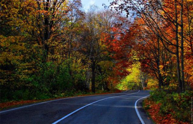
3. Karelia. Road Питер-Сортавала-Поросозеро-Костомукша-Калевала-Паанаярви
"Firs-pine-trees-pine ... on, girls! ... Lakes!»
On the roads of the country of thousand lakes are many areas of soil with "closed" turns and changes in elevation and simply slides to the lack of visibility of oncoming traffic. But all these inconveniences completely compensated vistas of forest and thicket lake.

Pongoguba, near the A135

The road to the National Park "Paanajarvi»

4. Blooming prairie spring, Kalmykia. Road "Volgograd - Elista - Stavropol».
In Kalmykia, the roads are good, apparently, part of the repair effect is positive, but the first 50-60 km of track in the Volgograd region awful - bumps, potholes, the road is divided into the trash. But to go down this road should not for checking the quality of asphalt. In the spring (late April - early May) before the eyes of travelers opens blooming steppe.
It is said that the one who podgadat the trip and fall on flowering tulips, view bright red steppe remembered for a lifetime. In these days of wild steppe suddenly erupts fabulous multi-colored carpet and filled with magical aroma of millions of blooming tulips and a clear steppe air thunders from sonorous and polyphonic orchestra of hundreds of large Melanocorypha - dzhurbaev.
Tulip field near the lake. Manych, near Elista

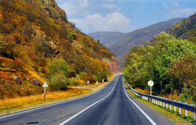
5. Southern serpentines and the Black Sea, Western Caucasus. Route M27 "Anapa - Adler».
The road from Anapa to Sochi is one of the most beautiful in our country: the endless switchbacks, mountains, fields, vineyards, sea and other landscapes of the Krasnodar Territory. The most beautiful and most difficult leg of the route on the distance from Dzhubga to Dagomys. There's a lot of cool closed turns, as well as periodic landslides.

Summer on the highway M-27 full of cars, traffic jams are often due to accidents and pedestrians in the resort town. Therefore, KMK, the best ride on the south in the Indian summer, when the main crowd of tourists have gone home.
Freshly built cable-stayed bridge on the road "Adler - Alpika Service»

6. North Caucasus, Karachai-Cherkessia. Sukhumi Military Road (A155, the plot of "Circassian - Dombay»).
Through the Main Caucasian Ridge historically existed three key roads: Sukhumi Military, Military-Ossetian and Georgian Military. Sukhumi Military Road from Cherkessk to Sukhum was considered the most beautiful of them all. Unfortunately, now it will not work on it to reach Sukhumi. For 7 km to Dombey, immediately after turning on Gonachhirskoe gorge worth PPC Teberdinsky reserve. Mot have to leave the parking lot in front of a cordon and crawl up the pass Klukhori walk on flat asphalt (!) Road. The pass itself became almost impassable even for pedestrians due to landslides and washouts. And pograntsy not asleep, the Russian border with Abkhazia as in any way.
But it is possible to turn in Dombay and walk along the famous ski resort. From Cherkessk to Dombaya asphalt is almost perfect.


Mountains near Dombai

7. North Caucasus, Karachai-Cherkessia. Route A157 "Min. water - Karachaevsk ».
Route A157 "Min. water - Karachaevsk "attractive two things: Pass Gum-Bashi and views of Mount Elbrus.


View on Elbrus pass Gum-Bashi

8. Elbrus, Kabardino-Balkaria. Route A158 "Baksan - Elbrus».
A158 scenic route "Baksan - Elbrus" runs through the valley and Kabardinsky territory of the Greater Caucasus mountain range.
The road to Mount Elbrus

Paved trail runs along a narrow Baksan Gorge and rises to two and a half thousand meters, almost to the very volcano Elbrus. This is the most mountainous road of all roads in the five canyons of Kabardino-Balkaria and the most decent track in the country, not counting federal. It is replete with steep ascents and descents and unexpected turns.
River Baskan accompanies the traveler all over the road, noise, rolls on numerous rapids, turning over huge boulders. It is not something that swim - even cross almost unreal.

9. North Caucasus, Kabardino-Balkaria. Road R291 "Urvan - Cherek Gorge - Upper Balkaria».
The road through the gorge Cherek - perhaps one of the most spectacular roads in the Caucasus.


When the gorge narrows to 40 meters road hides in a modern tunnel. And the old footpath still winds along the cliff.

Old road around the rock. No fences, climbing shoes height of about 500 meters, the noise of Cherek.

10. Northern Urals. Serov tract.
Serov path goes from Ekaterinburg to the north, the city of Serov, through thickly forested Ural mountains, rivers and swamps. First hundred kilometers (almost to Nizhny Tagil) tract is divided into two separate one-way road, two or three lanes each. And in some places the roads are divided by mountains and forest. And under Tagil they merge into one narrow, but good on the trails. Almost too good: because of the high accident rate lovers anneal / overtake on an opposite it is called "the road of death." Local GIBDDshniki instead of expanding the road invited the priest to bless the track, but for some reason this did not help.
Serov tract isolation EKAD, Sverdlovsk region

500 km from E-burg, Serov tract

And Serov tract original hang banners:
11. Southern Urals. The track "Ufa - Beloretsk».
Decoration highway "Ufa - Beloretsk" is a serpentine through the Ural Mountains. Bribes and that the cars on the road is very small. But it is marvelous stud "Teschin language" about half-way to Beloretsk. Beneath her lying skeletons passenger cars many years ago, and even semi-long-length.


12. Altai Mountains. Chuiski (M52).
It is this way is often called "the most beautiful roads of Russia." And no wonder, because the landscapes of the Altai Mountains are very diverse and stagger the imagination.

659 km Chui tract is a pointer "Start ascent to Chike-Taman." The road zigzags beautiful escapes upwards. In earlier times, until 1984, the pass was difficult and dangerous obstacle because of its narrowness, steepness and sharp climb. But after the next exacerbation of Russian-Chinese relations turned out that on the strategically important artery of our missiles just will not go to a meeting with the enemy because of his size. Therefore urgently organized a new road wider. But also old can ride!
Chike Taman

uschestvuyuschaya today the road passes close to the old Chu tract. Prior to the beginning of the XX century by Chike-Taman led equestrian trail with 34 twists and turns dangerous when lifting. It was a terrible way. This is how her contemporaries:
Chike-Taman. First of all, saying, scrawled on a roadside pole, at the top of the pass, the hand of a desperate coachman: "ETA is not Chike-Taman, and Hell-Ataman, forty-eight of sins." In ztom says it all, poured all the bile narugavshegosya utterly human, tortured himself and ruin here, maybe more than one horse.
Chike-Taman - a huge mountain range, block the way to the valley Ulegema, which goes tract. You are approaching close to the mountain, get out of the wagon and on foot climb the endless convolutions tract. A horse in the meantime toil over your crew. You went up to one hundred and sixty fathoms, and at the same rate should go down. A horizontal distance between the two extreme points of ascent and descent - only one outlet. All these separate path zigzags short and narrow radius of curvature is small, large deviations.
Rounded to the cart may not be able to turn around: the wheels hanging over the abyss nothing fenced. Another awkward step horse, and she, along with a load of slips down.
From the observation deck of modern roads are being overrun seen this way.


In the south Chuiski passes through dry steppe Chui, a kind of border zone between the Altai and Kazakh settlements. There is already felt the impact of dry Mongolia. Chu steppe landscapes of deserts and affect its severity not seen any trees or bushes or buildings. Around a cracked earth and plain islands wormwood and thorns. It is very clearly felt the scale of this world - expanses of steppe, the grandeur of the mountains, the height of the sky ...

13. Altai Mountains. Road "Gorno-Altaisk - Lake Teletskoye - Pass Katu-Yaryk" and Ulagansky tract
Teletskoye lake - Baikal in miniature, one of the most beautiful and deepest lakes in Russia. The lake water is so transparent that the bottom can be seen at 15 meters deep, and so cold that you risk becoming a frozen cake mix with reckless bathing in the "gentle" waters. The easiest way to get to it, turned off the Chui tract to Gorno-Altaisk, and then drive another 150 km to the village Iogach. From north to south lake, you can swim on the ferry.

The road from the lake to the pass goes through the valley of the river Chulyshman.

After overcoming the pass you can return to the M-52 on Ulagansky path through the sacred Ulagansky pass.

"Red Gate" Ulagan tract

14. Sayan, Khakassia. Usinsky tract ("Abakan - Kyzyl", M54)
Federal Highway "Yenisei" is a logical continuation of the historical Usinskoye tract connecting the capital of Khakassia first Usinskaya the village, then Kyzyl, and today, and with Mongolia. Altai Mountains is a little touched by civilization: there there are paved roads, large villages, camp sites and even climbing camp. Sayan is a central part of its pristine wild, do not know spokon century housing, wheel, ax, not to mention the economic development.

The path crosses the Western Sayan from start to finish. 80% of the territory of the Republic of Tuva is covered by mountains - the Western Sayan and Altai foothills in the south-west. Mezhgryadnye same basin are not worse than the Kalmyk steppe. All together looks absolutely amazing!

Road to the vast majority of its extent is quite decent coverage. Izdyryavlen only a portion of one of the passes, rather dangerous-looking. Despite the small busy road, columns in memory of crashed there are everywhere. No wonder: the profile of the road is unlikely to add to our human instinct of self-preservation. Do not slow down in this corner - do not fly away in a ditch, and in the valleys between the mountains.

Avalanche gallery at Usinskoye tract, which locals call the "Shelf". They say its winter covered with snow up to the top.

Sayan.

15. Around the Lake Baikal. The track "Viluy" - BAM - 110y winter road "New Uoyan - Ulyunhan" - Barguzinsky tract - M55 "Baikal" - Kultuk tract.
Roads around Lake Baikal little more direction. Quite tolerable federal highway "Viluy" comes from Tulun to Ust-Kut. It is here that terminate routes truckers and broken gravel road begins with burned bridges, running along the BAM to Severobaykalsk.

In Severobaykalsk road around the lake finally comes ashore lake and winds through it past the picturesque "capes tunnels" Circum-Baikal railway to Nizhneangarsk.

Because of the unusually warm winter 74go year road on the ice of Lake Baikal became neproezzhabelnoy, and BAM left without supplies. I had to quickly organize temporary land road to transport goods, connecting the mainland and the "construction of the century." In the winter, the route goes up to 80 trucks per day. Even then, the road was not easy, so along it runs through some warm beam put to rest and repair.


After the construction of BAM road became unnecessary. For a while it was used as a winter road, but the destruction of the bridges over the Barguzin difficult to move permanently.

Gradually, the road turned into the direction and became overgrown with legends. The route through the winter road chosen dzhipery, cycling and mototuristy. According to the sole survivor kilometer post with it called "110-th winter road».

Route around the lake is complex, but very beautiful. Quiet and unobtrusive northern taiga, tundra expansion, rapids of mountain rivers, ice, mountain passes, snow-capped peaks, rocky and forested peaks on the horizon. No cars - no counter or passing. Bears, caribou, deer, wood grouse, moose. Wood lives his life, and he does not care about human vanity.


Serpentine Kultuk tract

16. Siberia. Highway "Amur»
According to the magazine "At the wheel" highway "Amur" is on the 10th place in the list of the most interesting and beautiful roads in the world. Apparently, the journalist turned patriot or a lover of forests =) Never saw Russian road in such lists.
What cost to travel 6,000 km from Moscow? That's how much separates the capital from Chita, where begins the track "Cupid." The ancient merchant city was once a Russian trading outpost on the border with China. Now it starts from the most beautiful track in Russia. It is unique in every way. Firstly, it is one of the most modern roads in the country - it meets all international standards (for Russia it is very rare). Second, the road runs through the fantastically beautiful and almost untouched places - Transbaikalia and the Far East.
On both sides of the highway surrounded the taiga, and kept popping up on the highway deer and other animals. The route winds its way between the picturesque hills, the soaring upward, then down to the lowlands, and not a soul around ... Only here you know what our vast country, from one locality to another is 50-100 km, and between them - pristine Siberia.

18. Magadan. The track "Lena" (M56 "route Amur - Yakutsk") and Kolyma tract (P504 "Yakutsk - Magadan»).
- Well, we're on the Kolyma - welcome!
- No, it's better you to us!
© k / f "The Diamond Arm»
In 2006, the federal highway "Lena" was in first place in the top ten most terrible roads in the world. This road is almost blurred after every heavy rain. Steep passes, abandoned areas, blurred rains, rivers without bridges, dead, decaying villages, extremely harsh climate make the ride on the highway close to the extreme.
Photos track "Lena" from this famous series

But despite all this, why people are drawn to wild places? Let me quote Ivan odynokiy:
Since the early '90s track depopulated. Gold mines were closed, and the lack of work has forced people to throw so hard to relocate. Today the road is empty. Can be for several days did not see any oncoming traffic. Drivers megacities curse cork probably hard to imagine that there are other extreme, to which is also difficult to get used to. Any serious accident or breakdown - fraught, especially in winter.
But on the track soars elusive spirit of freedom, liberty and fraternity, which put in a makeshift sign "End of all restrictions." The track never knew what the traffic police. Here it is hello, all against all. Here any fire poured thick as chifir, tea. where are you from?
Tags
See also
Top 5 most beautiful roads in the world
Beautiful Road
Fantastically beautiful places in Russia
That's what they think the people of Spain to Russia. Honest answers to people who are caught unawares.
Beautiful landscapes of Russia bird's-eye view
Beautiful places in Russia
Comic collection Zen cards, which will look at life's problems from the other side
9 roads in Russia, breathtaking
Small cities of Russia, in which you can relax during the May holidays.
Road America