684
Archaeologists have discovered a previously unknown ancient construction in Jordan thanks to satellite imagery and drones

Photo: I. LaBianca; J. Blanzy
Many of us think that the Earth is studied very well, and a place for discovery are almost none. First of all, it concerns the science of history and archeology in particular. But modern technology is helping scientists to work to make more and more new discoveries. However, sometimes found historical artifacts prove to be the remains of microorganisms.
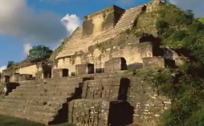
Sometimes people leading research, simply wrong, as it happened with the students who discovered the ancient city, which turned hemp field. But now we are talking about a real discovery that scientists have made in the ancient city of Petra, Jordan. More than two thousand years in this region was a huge building, hidden under a layer of soil - and no one knew it. Find ancient structure was made possible through the use of satellite images of Google Earth and photographing the area with the use of drones.
The ancient city of Petra seemed well studied - worked here and work dozens of archaeological expeditions. Peter (Arabic البتراء.) - Ancient city, the capital of Edom (Edom), later the capital of the Nabataean kingdom. Located in Jordan, at an altitude of 900 m above sea level and 660 meters above the surrounding terrain, Arava Valley, the narrow Siq.
Excavations carried out in the region has been two hundred years, all the work thoroughly documented. However, no one thought that in addition to those already found objects, can be located here something else. Although some scientists and could occur suspicion about the existence of something buried under tons of sand, these guesses no one checked and documented. "I'm sure that two centuries of research someone must have realized that there is something is, but systematic studies have not been conducted, nothing documented", - said Christopher Tuttle (Christopher Tuttle), executive director of the Council of American foreign research centers (Council of American Overseas Research Centers). "I have worked in this place for about 20 years, and I knew there was something there, but this finding could definitely be considered a discovery", - he said. The found object is located 900 meters from the center of Petra, and is away from places that are popular with tourists.

City Peter
For all time the archaeological site at Petra, scientists have found thousands of structural elements of the city, and tens of thousands of artifacts. All this is documented and cataloged. But the platform base 56 * 50 meters remained hidden from the eyes of archaeologists.
According to the scientists who made this discovery, a giant monument has been a cult place for residents. So far, the excavation has not yet been carried out here (enable), but experts believe that the platform has been built in the middle of the second century BC At the same time Peter was the commercial center of the ancient Arab kingdom of the Nabataeans.
Aerial view also showed the presence of smaller structures, the size of which 8, 5 * 8, 5 meters. base columns and a large staircase is also detected.
Many well-known sites of the city appeared in the period from 1. BC. to 2. BC This period is, for example, a Nabatean temple of Al Khazneh. Therefore, the presence of the object, whose age exceeds the age of the majority of the monuments of the city, attracting considerable interest from the scientific community to this place. Now scientists are trying to answer the question, and when people began to build the city here.
Aerial and satellite images are an indispensable assistant archaeologists. Now the team of scientists involved in the study of ancient settlements, replenished not only by historians, but also experts in aerial photography and information technology. "By creating an online platform for researchers and lovers of science, having trained an army of researchers of the 21st century, we will be able to find and keep a hidden heritage", - said Sarah Parsak, co-author of the discovery. Assist and amateurs who study satellite imagery Google Earth.
Another team of scientists from the University of California has been searching for the tomb of Genghis Khan, using drones and satellite imagery. Location of the grave, no one knows, there is only indirect indications of the place where it is located. According to one legend (there are many), over his grave paved riverbed, that it was impossible to find a place (in the same way he has been buried Sumerian King Gilgamesh of Uruk). According to other legends, over his grave we drove a lot of horses, there were planted trees. Nowadays, apart from historians searching for the tomb of Genghis Khan engaged thousands of volunteers that use satellite imagery, old texts, any information that could help in the search.
Lovers of archeology can provide significant help scientists taking part in the work of The Megalith Portal. It contains information about 25,000 prehistoric locations that users can visit, catalog, and make a review. And professionals and amateurs agree that an open online platform for the collective good of the archaeological research and ancillary works.
Source: geektimes.ru/post/277156/


Microsoft will buy LinkedIn for $ 26, 2 billion
Guide to the Antikythera Mechanism has helped scientists understand the purpose of the ancient computer