Google has significantly improved the quality of satellite maps
 Bashny.Net
Thanks to the satellite Landsat 8
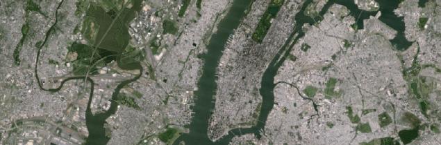
Old maps Google Maps: District of Central Park in New York
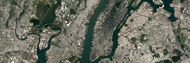
New maps Google Maps
Every few months Google updates Google satellite maps Maps and Google Earth, adding new satellite images and improving processing methods. For example, three years ago, I learned to be a mosaic of cloudless sky.
Today, Google held the largest satellite maps updated in the last few years, using satellite imagery Landsat 8.
Earth remote sensing satellite Landsat 8, launched in February 2013. He takes pictures with a resolution of 15/30/100 meters per pixel. Sensors Operational Land Imager (OLI) and the Thermal InfraRed Sensor (TIRS) have a higher signal-to-noise ratio (SNR) and allow you to shoot up to 12 bits per pixel. OLI image sensor receives nine bands of visible light and near infrared range and TIRS - two driving bands (thermal) IR. Positioning accuracy of instruments is 12 and 41 meters, respectively.
Google says that the new database of satellite images are not only used more high-quality images, but also the new processing techniques and gluing the photos used. Not the least role in this played a better source data, because the new Landsat 8 satellite used long linear arrays of photosensors, to eliminate immediately the entire width of the field of view of the satellite - 185 kilometers
. Improved technique drawing cloudless mosaics, so that seamless mosaic as a whole has become more precise and clear. This is an important improvement, because every day the clouds closed about 70% of the earth's surface.
New photos only improve the quality of satellite images secondary and general plan (zoom from 0 to 12) , but not the most detailed pictures of cities at maximum zoom, which supply other private and government satellites, including by DigitalGlobe.
Despite this, the difference in quality is amazing.
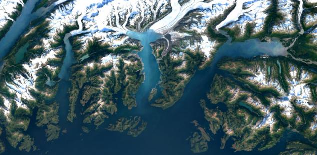
Columbia Glacier in Alaska
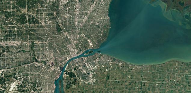
City of Detroit, USA
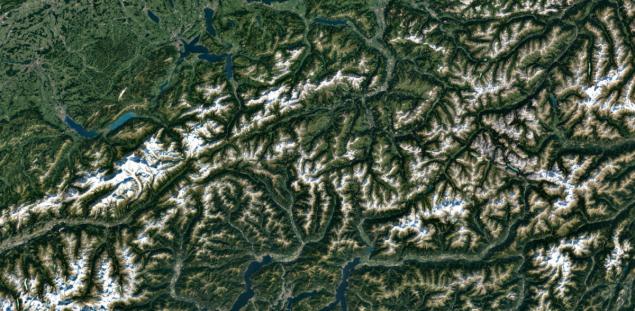
Swiss Alps
Toolbox Landsat 8 is much more advanced than that of the Landsat 7 - and it is immediately evident in the photographs, which have better detail, more saturated colors. In addition, Landsat 8 different unprecedented refresh images every day it takes almost twice as much territory than Landsat 7 (400 scenes per day from Landsat 8 against 250 scenes per day from Landsat 7)
. Google admits that in recent years was a mosaic of satellite maps only from photos Landsat 7, which after a hardware failure in 2003 began to send low-quality data - photos with large diagonal white stripes. For example, here is how photos look the same in the US territory of Oklahoma City in 2000 and 2003.
Oklahoma City, July 9th, 2000
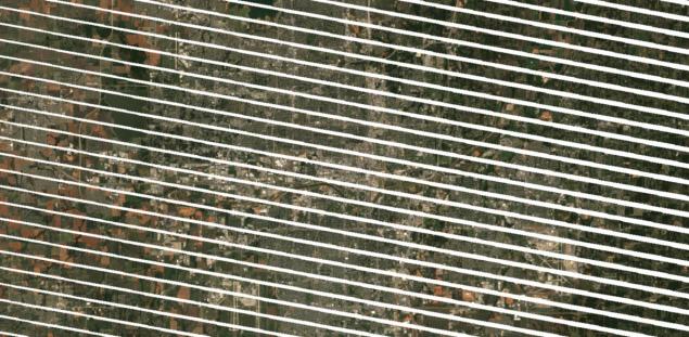
Oklahoma City, September 20, 2003
Photos with such bands difficult to stick together into a single mosaic.
For processing using standard Earth Engine API programming interfaces available including third-party researchers. The same API used by scientists to produce interactive maps of forest cover change maps of the planet and the risk of malaria.
Mosaic of the Google planet surface made from photos Landsat 8 total volume of approximately 1 petabyte , the combined resolution of 700 trillion pixels
For bonding 1 petabyte Google took photos of more than 6 million hours of CPU time: the problem for nearly a week are counted on a cluster of 43 000 computers in the cloud computing Google
.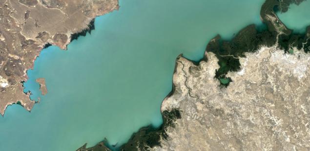
Lake Balkhash, Kazakhstan
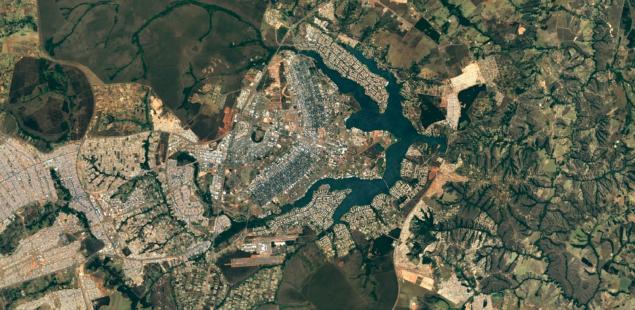
City Brasilia, Brazil
From today, new satellite photos are open in all Google mapping products, including on the satellite layer of Google Maps.
Source: geektimes.ru/post/277824/

Old maps Google Maps: District of Central Park in New York

New maps Google Maps
Every few months Google updates Google satellite maps Maps and Google Earth, adding new satellite images and improving processing methods. For example, three years ago, I learned to be a mosaic of cloudless sky.
Today, Google held the largest satellite maps updated in the last few years, using satellite imagery Landsat 8.
Earth remote sensing satellite Landsat 8, launched in February 2013. He takes pictures with a resolution of 15/30/100 meters per pixel. Sensors Operational Land Imager (OLI) and the Thermal InfraRed Sensor (TIRS) have a higher signal-to-noise ratio (SNR) and allow you to shoot up to 12 bits per pixel. OLI image sensor receives nine bands of visible light and near infrared range and TIRS - two driving bands (thermal) IR. Positioning accuracy of instruments is 12 and 41 meters, respectively.
Google says that the new database of satellite images are not only used more high-quality images, but also the new processing techniques and gluing the photos used. Not the least role in this played a better source data, because the new Landsat 8 satellite used long linear arrays of photosensors, to eliminate immediately the entire width of the field of view of the satellite - 185 kilometers
. Improved technique drawing cloudless mosaics, so that seamless mosaic as a whole has become more precise and clear. This is an important improvement, because every day the clouds closed about 70% of the earth's surface.
New photos only improve the quality of satellite images secondary and general plan (zoom from 0 to 12) , but not the most detailed pictures of cities at maximum zoom, which supply other private and government satellites, including by DigitalGlobe.
Despite this, the difference in quality is amazing.

Columbia Glacier in Alaska

City of Detroit, USA

Swiss Alps
Toolbox Landsat 8 is much more advanced than that of the Landsat 7 - and it is immediately evident in the photographs, which have better detail, more saturated colors. In addition, Landsat 8 different unprecedented refresh images every day it takes almost twice as much territory than Landsat 7 (400 scenes per day from Landsat 8 against 250 scenes per day from Landsat 7)
. Google admits that in recent years was a mosaic of satellite maps only from photos Landsat 7, which after a hardware failure in 2003 began to send low-quality data - photos with large diagonal white stripes. For example, here is how photos look the same in the US territory of Oklahoma City in 2000 and 2003.

Oklahoma City, July 9th, 2000

Oklahoma City, September 20, 2003
Photos with such bands difficult to stick together into a single mosaic.
For processing using standard Earth Engine API programming interfaces available including third-party researchers. The same API used by scientists to produce interactive maps of forest cover change maps of the planet and the risk of malaria.
Mosaic of the Google planet surface made from photos Landsat 8 total volume of approximately 1 petabyte , the combined resolution of 700 trillion pixels
For bonding 1 petabyte Google took photos of more than 6 million hours of CPU time: the problem for nearly a week are counted on a cluster of 43 000 computers in the cloud computing Google
.

Lake Balkhash, Kazakhstan

City Brasilia, Brazil
From today, new satellite photos are open in all Google mapping products, including on the satellite layer of Google Maps.
Source: geektimes.ru/post/277824/
Tags
See also
Five scientific discoveries made with the help of Google Earth (5 photos)
Iran will create a "Google Earth"
The best satellite photos DigitalGlobe 2012
Google Earth - debunker military secrets
Google Earth in 3D
298 years ago founded the Tula Arms Plant
The Bible through the eyes of Google Earth (6 photos)
Birdhouses from Google Maps and Shu-Chun Hsiao
25 most interesting places to see in Google Earth
In Google Earth, you can blow up "gruel"