769
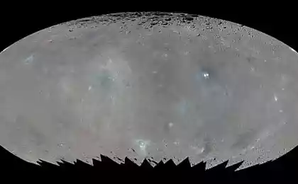
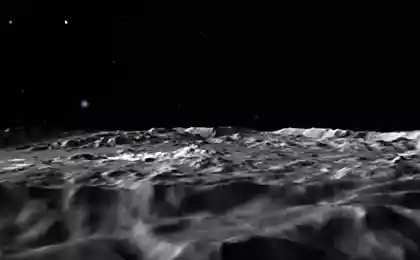
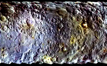
NASA released a map of Ceres
70,756,147
When you click the image to open in full size (NASA / JPL-Caltech / UCLA / MPS / DLR / IDA) i>
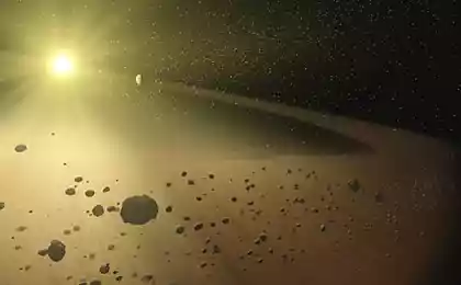
Dawn probe continues, and scientists - to process information sent by the station. Now, NASA published a detailed map of the planetoid. As it turned out, Ceres enough varied terrain, the height difference can be 15 kilometers.
The map was created on the basis of images that interplanetary station sends Dawn. Experts analyzed the various photos, and, based on published maps developed. In addition, scientists have made some conclusions about the relief of Ceres.

When you click the image to open in full size (NASA / JPL-Caltech / UCLA / MPS / DLR / IDA) i>
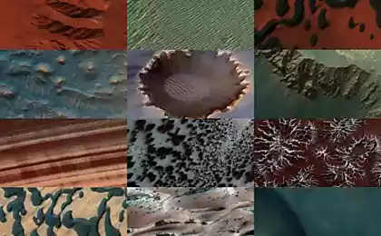
"The craters that we found in the Ceres, if we analyze their depth and diameter, very similar to what we have found on Dione and Tethys, two icy satellites of Saturn, the density and size are approximately the same as that of Ceres," - he said Paul Schenk, one of the representatives of the project team.
Some of the craters and other formations on the surface of the planetoid given official names, the names of spirits and deities that are relevant to agriculture in the mythology of various civilizations.
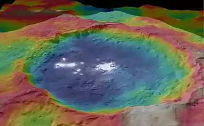
So far, the most interesting object is a crater on Ceres Occator, a width of 90 kilometers and a depth of 4 kilometers. At the bottom of the crater are the very bright spots, whose origins are now trying to find scientists.
There are deeper craters, for example, Dantu (120 km in diameter and 5 deep) and Ezinu (same size). The larger object is Urvara crater with a diameter of 160 km and a depth of 6 km. And in the center of the crater is a peak height of 3 kilometers.
The diameter of the Ceres is 940 km, and is the largest object in the asteroid belt, which lies between Mars and Jupiter. In fact, the size of Ceres, is about 40% the size of Pluto.
Source: geektimes.ru/post/259542/
When you click the image to open in full size (NASA / JPL-Caltech / UCLA / MPS / DLR / IDA) i>
Dawn probe continues, and scientists - to process information sent by the station. Now, NASA published a detailed map of the planetoid. As it turned out, Ceres enough varied terrain, the height difference can be 15 kilometers.
The map was created on the basis of images that interplanetary station sends Dawn. Experts analyzed the various photos, and, based on published maps developed. In addition, scientists have made some conclusions about the relief of Ceres.

When you click the image to open in full size (NASA / JPL-Caltech / UCLA / MPS / DLR / IDA) i>
"The craters that we found in the Ceres, if we analyze their depth and diameter, very similar to what we have found on Dione and Tethys, two icy satellites of Saturn, the density and size are approximately the same as that of Ceres," - he said Paul Schenk, one of the representatives of the project team.
Some of the craters and other formations on the surface of the planetoid given official names, the names of spirits and deities that are relevant to agriculture in the mythology of various civilizations.
So far, the most interesting object is a crater on Ceres Occator, a width of 90 kilometers and a depth of 4 kilometers. At the bottom of the crater are the very bright spots, whose origins are now trying to find scientists.
There are deeper craters, for example, Dantu (120 km in diameter and 5 deep) and Ezinu (same size). The larger object is Urvara crater with a diameter of 160 km and a depth of 6 km. And in the center of the crater is a peak height of 3 kilometers.
The diameter of the Ceres is 940 km, and is the largest object in the asteroid belt, which lies between Mars and Jupiter. In fact, the size of Ceres, is about 40% the size of Pluto.
Source: geektimes.ru/post/259542/


