1649
Beautiful pictures of Earth from space (11 photos)
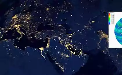
The photos show the power and unpredictability of our planet
1. coast of Sri Lanka, 26.12.2004
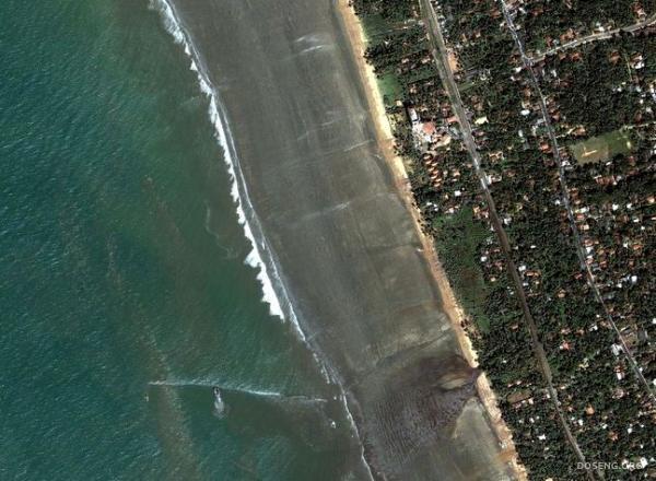
Ocean quickly moves back to 400 m. In the south-eastern coast of Sri Lanka - in just 5 minutes before the devastating tsunami.
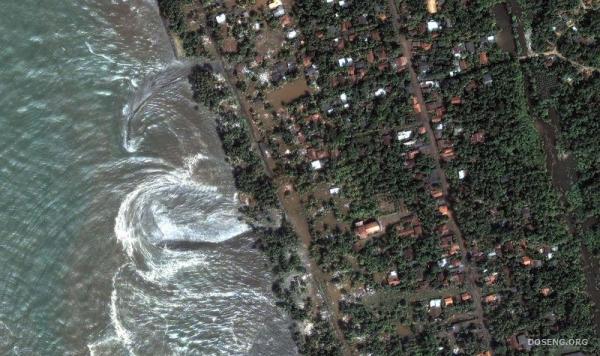
Rushing water beating against the shore - just a few moments before hitting the main wall of water.
2. Fan alluvial deposits, the province Xinjiang, China

This photograph, taken 02/05/2002, shows a fan alluvial deposits formed on the southern border of the Chinese desert Taklimakan.
Normally, such a fan is formed when water is drained out of the canyon, and each new stream eventually becomes clogged due to sludge.
As a result, a triangle of active and inactive channels. Blue channels on the left - are active.
3. The retreating glaciers in the Bhutan Himalayas

Beautiful and clear evidence that glaciers slowly melting due to global warming.
Easily distinguishable edge of glacial valleys, into water, and forming a lake - a trend,
noticed only in the past few decades.
4. Cyclone Isabella 2003

A horrifying picture of the cyclone Isabella received from the International Space Station in 2003, demonstrates the enormous size of his eyes.
This was the strongest cyclone in 2003, it reached a speed of 165 miles / hour (~ 265 km / h).
5. The eastern coast of Greenland, 21.08.2003

Fractal Greenland coastline with many inlets - view from space.
Small white spots in water seems to represent ice come from deeper fjords,
which stretch up to the glacier, covers most of the island.
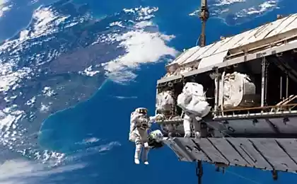
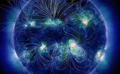
6. Aurora

Amazing and terrifying picture natural phenomenon known as the aurora borealis.
The photo was taken c shuttle Atlantis during STS-117 expedition.
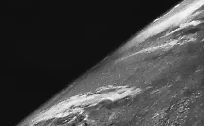
7. The total solar eclipse, 1999

In this photo taken Aug. 11, 1999 on board the Mir space station, you can see how the Earth casts a shadow on the moon.
This shadow swept across the planet at a speed of 2000 km / h. All that was provided in its center, is plunged into darkness.
It was probably one of the last pictures taken on the world.
8. Reserve Egmont, New Zealand
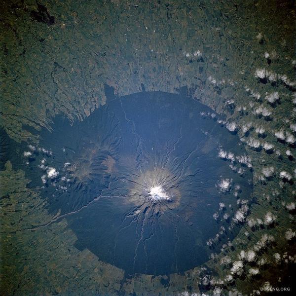
Last eruption occurred Egmont in 1755, and now he is in the center of the reserve Egmont.
The reserve was created to ensure the preservation of forests within a radius of 9, 5 km. from the top of the volcano, from space looks like a huge dark green disc.
The picture was taken during an expedition STS-110 in April 2002
9. The eruption of Mount Etna, October 2001

On the picture, taken in 2001 with the International Space Station is seen strong volcanic eruption on the island. Sicily,
which was formed as a result of the cloud of ash reached Libya.
On a large picture near the volcano is visible lighter smoke, which was formed due to the fact that the lava ignited nearby forest.
10. Richat Structure, Mauritania

It has been much debate as to the cause of the structure Richat located in the Sahara Desert in Mauritania. First, because of the round shape, it was thought that this - the crater caused by the fall of a meteor. But then, this version was rejected, as was found near the corresponding traces of impact. Now it is believed that this huge contraption (~ 48 km. In diameter) is a stone dome, formed due to erosion. The image was taken using the latest space Radiometer (Aster) October 7, 2000
1. coast of Sri Lanka, 26.12.2004

Ocean quickly moves back to 400 m. In the south-eastern coast of Sri Lanka - in just 5 minutes before the devastating tsunami.

Rushing water beating against the shore - just a few moments before hitting the main wall of water.
2. Fan alluvial deposits, the province Xinjiang, China

This photograph, taken 02/05/2002, shows a fan alluvial deposits formed on the southern border of the Chinese desert Taklimakan.
Normally, such a fan is formed when water is drained out of the canyon, and each new stream eventually becomes clogged due to sludge.
As a result, a triangle of active and inactive channels. Blue channels on the left - are active.
3. The retreating glaciers in the Bhutan Himalayas

Beautiful and clear evidence that glaciers slowly melting due to global warming.
Easily distinguishable edge of glacial valleys, into water, and forming a lake - a trend,
noticed only in the past few decades.
4. Cyclone Isabella 2003

A horrifying picture of the cyclone Isabella received from the International Space Station in 2003, demonstrates the enormous size of his eyes.
This was the strongest cyclone in 2003, it reached a speed of 165 miles / hour (~ 265 km / h).
5. The eastern coast of Greenland, 21.08.2003

Fractal Greenland coastline with many inlets - view from space.
Small white spots in water seems to represent ice come from deeper fjords,
which stretch up to the glacier, covers most of the island.
6. Aurora

Amazing and terrifying picture natural phenomenon known as the aurora borealis.
The photo was taken c shuttle Atlantis during STS-117 expedition.
7. The total solar eclipse, 1999

In this photo taken Aug. 11, 1999 on board the Mir space station, you can see how the Earth casts a shadow on the moon.
This shadow swept across the planet at a speed of 2000 km / h. All that was provided in its center, is plunged into darkness.
It was probably one of the last pictures taken on the world.
8. Reserve Egmont, New Zealand

Last eruption occurred Egmont in 1755, and now he is in the center of the reserve Egmont.
The reserve was created to ensure the preservation of forests within a radius of 9, 5 km. from the top of the volcano, from space looks like a huge dark green disc.
The picture was taken during an expedition STS-110 in April 2002
9. The eruption of Mount Etna, October 2001

On the picture, taken in 2001 with the International Space Station is seen strong volcanic eruption on the island. Sicily,
which was formed as a result of the cloud of ash reached Libya.
On a large picture near the volcano is visible lighter smoke, which was formed due to the fact that the lava ignited nearby forest.
10. Richat Structure, Mauritania

It has been much debate as to the cause of the structure Richat located in the Sahara Desert in Mauritania. First, because of the round shape, it was thought that this - the crater caused by the fall of a meteor. But then, this version was rejected, as was found near the corresponding traces of impact. Now it is believed that this huge contraption (~ 48 km. In diameter) is a stone dome, formed due to erosion. The image was taken using the latest space Radiometer (Aster) October 7, 2000