Japan creates an alternative to GPS with centimeter resolution
 Bashny.Net
Japanese company Mitsubishi Electric has announced its intention to launch into orbit satellite constellation, which after 2018 will provide high precision geopositioning. According to the authors ideas, with increasing precision coordinates extend the possibility of using satellite navigation in practical problems. For example, robotic cars can just go on your belt, knowing the satellite coordinates of road markings.
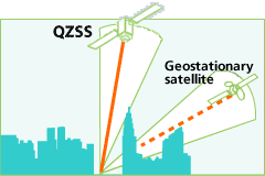
System Quazi-Zenith Satellite System (QZSS) designed to complement the American GPS in Japan. QZSS satellites will allow to calculate the location of the receiver with an accuracy of 1-3 centimeters.
«GPS-positioning can produce an error of up to 10 meters due to the different types of errors - says Yuki Sato, Engineer Research Division Advanced Technology R & D Center in the company of Mitsubishi Electric. - And in Japan the GPS signal is often blocked by mountains and skyscrapers, so that in many places it is simply not available. " Indeed, between the skyscrapers in downtown Tokyo is virtually impossible to catch him.
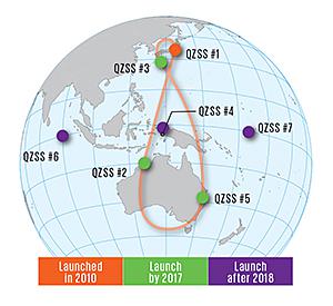
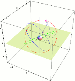
Mitsubishi Electric Company is responsible for substantially all "space" part of the project, including manufactures satellites. Japan Aerospace Exploration Agency (JAXA) launched the first satellite QZSS in September 2010. Three more things will start before the end of 2017, and then the last three. This is more than enough to cover the entire country and its surroundings. From the point of view of an observer on Earth, the satellites in the sky form a shape similar to the asymmetrical number "eight". Wherein at least one satellite in a geosynchronous orbit will always be kvazizenitnom position, i.e. with the elevation angle of more than 70 °. It is critically important for the residents of megacities.
The Japanese Government has allocated $ 500 million for the first three satellites, as well as $ 1, 2 billion in 1200 for the construction of the reference stations on the ground.
Management of terrestrial stations entrusted to a private company Quazi-Zenith Satellite System Services, created specifically for this purpose.
QZSS satellites fitted atomic clock based on rubidium. To eliminate inaccuracies in the triangulation control station continuously monitors the readings from the satellite and its actual location relative to the reference stations. Then transmitted to the satellite information for correction. According to engineers, the system requires constant correction so that the satellite broadcast flow rate of 2 kbits / s.
Tests of the first satellite QZS-1 показали, after correction it provides precision positioning with an error of not more than 1 cm 3 in the horizontal direction and 2 cm in the vertical 9. Such accurate navigation system can be used, for example, for automatic movement of vehicles and agricultural equipment.
Mitsubishi Electric is emphasizing low cost QZSS, as compared to other satellite positioning system. For example, the budget of Galileo has already exceeded $ 6 9 billion.
Source: habrahabr.ru/post/221059/
Tags
satellite navigation
geolocation
GPS
Japan
Mitsubishi Electric
Quazi-Zenith Satellite System
QZSS
geosynchronous
See also
Elephant seals found in favor of carbon monoxide
Tesla plans to change the energy infrastructure in the world?
About the power of intention.
Ford demonstrates virtual reality system
The U.S. produced the successful launch of GPS satellite
Laser light (2 photos)
In the production of running a pilot batch of processors
Google paves superfast cable to the bottom of the Pacific Ocean
Did You know that the kilogram is getting heavier?
Elon Musk swings on the creation of a global satellite system for Internet access