How to find water for wells: dismantle three effective ways to search
 Bashny.Net
Water is an exceptional gift, without which life on earth is simply impossible. Water is a permanent element of the daily cycle: watering plants, household needs, cooking... Acquiring land on which there is the slightest hint of the source of this inorganic compounds the problem of how to find water for a well or wells, is becoming one of the key. We offer you to disassemble the most popular and effective ways.
A little about aquifers
In the soil, usually within 2-3 aquifer, separated by confining layers, the horizons of which can vary greatly.
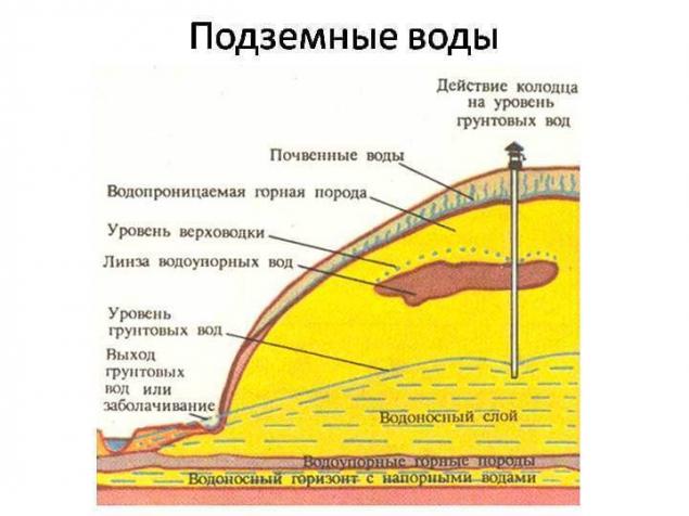
Aquifers represent a kind of underground lake, mainly consisting of water-soaked sand.
At a least depth of about 25 meters is the water in the first layer, referred to as "subcutaneous" or perched. It is formed by filtration through the soil melt water and atmospheric precipitation. This water is only suitable as watering gardens and for household needs.
Water the second layer of mainland sand is suitable for human consumption. The third layer represent water with excellent taste, and rich in mineral compounds and mineral salts.
Effective ways of finding water
Ways to determine the proximity of water to the surface, there are more than a dozen. Search water bore can be carried out using one of the following effective ways.
Using silica gel
For this purpose granules of the substance had previously been thoroughly dried in the sun or in the oven and put in unglazed clay pot. To determine the number of granules absorbed moisture pot before burying you must weigh. A pot of silica gel wrapped in non-woven material or a thick cloth, burrows into the soil to a depth of about one meter in place at the site where it is planned to drill the well. After one day, the pot contents can be removed and again weighed: the heavier it is, the more moisture it has absorbed, which in turn indicates the presence of a nearby aquifer.
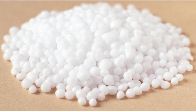
The use of silica gel are related to the category of substances having the property to absorb moisture and hold it, will allow only a couple of days to determine the best location for drilling or equipping a well.
In order to narrow the search space of water to wells, it is possible to use simultaneously several of these clay jars. To determine more precisely the optimal place for drilling by re-instillation of a pot of silica gel.
Moisture-absorbing properties has also the usual brick from red clay and salt. The definition of an aquifer occurs similarly to pre-and re-weighing and vyschityvanii difference.
Barometric method
Readings of 0.1 mm of mercury of the barometer corresponds to the difference in elevation of the pressure in 1 meter. To operate the appliance you must first measure its pressure on the Bank of an existing pond nearby, and after along the device to move to the site of the proposed arrangement of source water extraction. In place of drilling measurements of air pressure are made again and calculated the depth of the water.
The presence and depth of groundwater has also successfully determined using a conventional barometer aneroid
For example: the reading of the barometer on the banks of the river are 545,5 mm, and the area — 545,1 mm. the Level of groundwater is calculated according to the principle: 545,5-545,1=0.4 mm, i.e. the depth of the well will be at least 4 meters.
Exploration drilling
A trial exploration drilling is one of the most reliable ways to find water for wells.
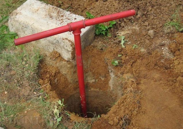
Exploration drilling allows us not only to identify the presence and level of occurrence of water, but also to determine the characteristics of the soil layers, occurring before and after the aquifer Drilling is done with the use of common garden hand drill.
Since the depth of the prospecting wells in an average of 6-10 meters, it is necessary to provide the possibility to increase the length of the handle. For work, it is sufficient to use a drill, a screw diameter of which is 30cm. As penetration of the drill in order not to break the tool excavation must be carried out through every 10-15 cm soil layer. Moist silver sand can be seen at a depth of about 2-3 meters.
An illustrative example of test drilling are presented in the video:
SUBSCRIBE to OUR youtube channel that allows you to watch online, download from YouTube free video about the recovery, the rejuvenation of man. Love for others and ourselves, as the feeling of high vibrations — an important factor for improvement .
Put LIKES and share with your FRIENDS!
www.youtube.com/channel/UCXd71u0w04qcwk32c8kY2BA/videos
Place under the arrangement of the well shall be located not closer than 25-30 meters with respect to the drainage of trenches, compost and garbage heaps, and other sources of pollution. The successful placement of the well is in an upland area.
Repeating terrain aquifers in the high places are the source of more pure filtered water.
Perched rainwater and melt water always flows down from the hills to the lowland, which gradually drains to impermeable layer, which in turn displaces clean filtered water to the top of the aquifer.
P. S. And remember, only by changing their consumption — together we change the world! ©
Source: diz-cafe.com/voda/kak-najti-vodu-dlya-skvazhiny.html
A little about aquifers
In the soil, usually within 2-3 aquifer, separated by confining layers, the horizons of which can vary greatly.

Aquifers represent a kind of underground lake, mainly consisting of water-soaked sand.
At a least depth of about 25 meters is the water in the first layer, referred to as "subcutaneous" or perched. It is formed by filtration through the soil melt water and atmospheric precipitation. This water is only suitable as watering gardens and for household needs.
Water the second layer of mainland sand is suitable for human consumption. The third layer represent water with excellent taste, and rich in mineral compounds and mineral salts.
Effective ways of finding water
Ways to determine the proximity of water to the surface, there are more than a dozen. Search water bore can be carried out using one of the following effective ways.
Using silica gel
For this purpose granules of the substance had previously been thoroughly dried in the sun or in the oven and put in unglazed clay pot. To determine the number of granules absorbed moisture pot before burying you must weigh. A pot of silica gel wrapped in non-woven material or a thick cloth, burrows into the soil to a depth of about one meter in place at the site where it is planned to drill the well. After one day, the pot contents can be removed and again weighed: the heavier it is, the more moisture it has absorbed, which in turn indicates the presence of a nearby aquifer.

The use of silica gel are related to the category of substances having the property to absorb moisture and hold it, will allow only a couple of days to determine the best location for drilling or equipping a well.
In order to narrow the search space of water to wells, it is possible to use simultaneously several of these clay jars. To determine more precisely the optimal place for drilling by re-instillation of a pot of silica gel.
Moisture-absorbing properties has also the usual brick from red clay and salt. The definition of an aquifer occurs similarly to pre-and re-weighing and vyschityvanii difference.
Barometric method
Readings of 0.1 mm of mercury of the barometer corresponds to the difference in elevation of the pressure in 1 meter. To operate the appliance you must first measure its pressure on the Bank of an existing pond nearby, and after along the device to move to the site of the proposed arrangement of source water extraction. In place of drilling measurements of air pressure are made again and calculated the depth of the water.
The presence and depth of groundwater has also successfully determined using a conventional barometer aneroid
For example: the reading of the barometer on the banks of the river are 545,5 mm, and the area — 545,1 mm. the Level of groundwater is calculated according to the principle: 545,5-545,1=0.4 mm, i.e. the depth of the well will be at least 4 meters.
Exploration drilling
A trial exploration drilling is one of the most reliable ways to find water for wells.

Exploration drilling allows us not only to identify the presence and level of occurrence of water, but also to determine the characteristics of the soil layers, occurring before and after the aquifer Drilling is done with the use of common garden hand drill.
Since the depth of the prospecting wells in an average of 6-10 meters, it is necessary to provide the possibility to increase the length of the handle. For work, it is sufficient to use a drill, a screw diameter of which is 30cm. As penetration of the drill in order not to break the tool excavation must be carried out through every 10-15 cm soil layer. Moist silver sand can be seen at a depth of about 2-3 meters.
An illustrative example of test drilling are presented in the video:
SUBSCRIBE to OUR youtube channel that allows you to watch online, download from YouTube free video about the recovery, the rejuvenation of man. Love for others and ourselves, as the feeling of high vibrations — an important factor for improvement .
Put LIKES and share with your FRIENDS!
www.youtube.com/channel/UCXd71u0w04qcwk32c8kY2BA/videos
Place under the arrangement of the well shall be located not closer than 25-30 meters with respect to the drainage of trenches, compost and garbage heaps, and other sources of pollution. The successful placement of the well is in an upland area.

Repeating terrain aquifers in the high places are the source of more pure filtered water.
Perched rainwater and melt water always flows down from the hills to the lowland, which gradually drains to impermeable layer, which in turn displaces clean filtered water to the top of the aquifer.
P. S. And remember, only by changing their consumption — together we change the world! ©
Source: diz-cafe.com/voda/kak-najti-vodu-dlya-skvazhiny.html
Tags
See also
How to choose a water filter
How can I remove the pump from the well if it is stuck: advice from the professionals, and folk wisdom
How to choose a heater to testify: tips and advice
How to make a water filter with your hands: a review of the most popular homemade
How to make a water pump with your hands
How to choose a filter for water purification in a country house?
Abyssinian wells: the unit well of the needle with your hands
How to find your competitive advantage in 15 minutes
How to choose a water heater for villas