The most beautiful places on planet Earth
 Bashny.Net
My husband and I are avid travelers! We traveled halfway around the world in search of adventure! Now we create videos from our travels and we present you a video clip about the Most incredible places on earth! (in our version).
Angel falls – the highest free-falling waterfall in the world. It is located in a mountain area of Guyana in Venezuela on the river Carrao, which is one of the tributaries of the Orinoco. In Spanish the name of the waterfall translates as "angel."
Since ancient times the local Indian tribes called the waterfall Churun-Measure ("Waterfall of the deepest place"), and a plateau from which it drops – Auyan-Tepui, which means "devil's mountain", because of the permanent thick fog that shrouded it.
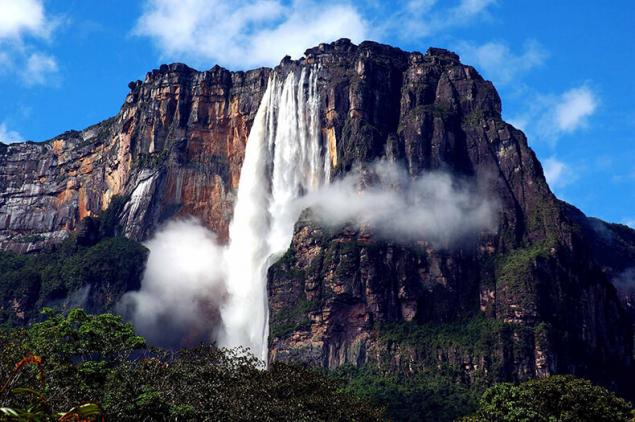
The main attraction of Venezuela
In 1910, the waterfall was discovered by the Spanish Explorer Ernesto Sanchos La Cruz, but a world fame thanks to the American pilot and gold prospector James Crawford angel.
In 1949, the waterfall was dispatched an expedition of the National geographic society (USA), which determined the main parameters of angel. And in 1993 UNESCO made waterfall in the world heritage list of humanity. Now the angel is located on the territory of Canaima national Park and is considered the main attraction of Venezuela.
Waterfall surrounded by tropical forests and special roads for it ... Therefore, tourists are delivered to the angel through the air on a light aircraft or water in a canoe with a motor. The most desperate thrill-seekers can jump off the edge of the plateau on a hang glider. The starting point for tours to the waterfall is a small village Kunimi. With the influx of tourists the town has changed, there were few resorts, restaurants and souvenir shops.
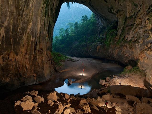
The sondong cave in Central Vietnam, now bears the title of the largest caves in the world. It is located in the heart of the national Park Phong Nha Provides to Binh province, near the Vietnamese-Lao border. Its dimensions reach record levels – the height is 200 meters, width – 150 meters, length — more than 5 kilometers. Total unique education, over 38.5 million m3.
Lying in the depths of the jungle entrance to the cave was first found by a local resident named Ho Khanh in 1991, but wafting out the roar of the water flow and steep descent did not allow him to explore it from the inside. Only in 2009 a group of British scientists led by Howard Lamberton succeeded in Vietnam to detect and successfully explore Shandong, after which they announced the official opening of the cave and confirmed that the dimensions allow you to assign it the status of the biggest on the planet.
"Hang Sơn Đoòng" in Vietnamese means "mountain river cave". It really is an underground river with a rapid current, which floods the individual parts of Shandong during the rainy season. In addition it has its own jungle, the climate and even real clouds that are formed due to the large temperature difference. Two huge Windows of a giant underground cavity allow light to penetrate into its many parts, making grow inside a lush jungle with a 3-meter trees.
Shandong is famous not only for its impressive size, but also the best examples of cave formations on the planet. Here you can find interesting fossils, stalactites and some of the highest stalagmites in the world with a height of 70 meters. A particularly impressive formation is considered to be the "Hand dog" and the place called the Cactus Garden. Also in the cave there are examples of giant cave pearls, which is filled with limestone layers.
The flora and fauna of Shandong – a godsend for any scientist. In the caves there are many rare species of plants, and recently was even discovered several new species of animals. Monkeys, hornbills and flying foxes – they all live in an unusual underground jungle.
The unique cave was formed as a result of a long process of leaching of the limestone by water flow of about 2-5 million years ago.
In early August 2013 on a tour in Shandong went to the first tour group. To get inside the attractions, you must use the rope to go underground to a depth of 80 meters. Tourists break there a tent camp, spending time in the labyrinths of underground caves or cozy sitting by the fire. The cost of such entertainment is $ 3,000. In the period from September to March access to the cave is closed as it is the rainy season, during which many areas are flooded. Schedule for 2015 will be posted on the website, organise excursions at the end of this year.
The world's largest cave, Sơn Đoòng called attracting the attention of many film companies such as BBC, National Geographic, and the well-known Japanese and Brazilian teams. In 2011, she appeared on the pages of the popular magazine National Geographic.
Mount Roraima is the most famous and concurrently the high Venezuelan tepui (table mountain), reaching a height of 2810 meters. It is located on the border of Brazil (state of Roraima), Venezuela (Canaima national Park), and Guyana (the highest point of the country). The surface area of the plateau of the “big blue-green mountain”, as it is called, is 30 km2.
The local Indians, in turn, called her "the navel of the earth" and believe that at the top of the mountain lives the goddess Queen is the mother of all people. Despite the fact that all tepui — it is the home of the gods, that Roraima is considered a Holy place. Almost always it is surrounded by whitish clouds, giving it a mystery that can not fail to attract adventurers, and admirers of beauty.
For a long time the most beautiful mountain of South America remained inaccessible and unknown. Only the bravest Indians overcame a difficult way to spell, according to their beliefs, the lands lying through almost impassable swamps and forests.
The first European Explorer who studied the area in 1835, was a German scientist Robert Shomburgk. He was struck by the majestic mountains with unique ecosystems, but attempts to climb one of them did not succeed.
Half a century later, in 1884, it managed to make two British scientists Everard Im Turnu and Harry Perkins, who conquered the top of mount Roraima, and revealed all the secrets of this mysterious terrain. It is on this route of modern travellers climb to the plateau of the famous Venezuelan tepui.
Written by pioneers of report on wonderful journeys to unexplored lands inspired by the famous writer Arthur Conan Doyle for creating the science fiction novel "the Lost world" about the discovery of the plateau, which was inhabited by prehistoric species of plants and animals.
Constant cloud cover around the mountain is associated with the fact that at the foot of Roraima rivers originate from the Amazon, Orinoco and Essequibo.
The surrounding scenery is really very similar to a fantasy world with black rocks, hung with threads of waterfalls, colorful ponds, wild vegetation and rare animals.
Almost the entire surface of the plateau mount black from "desert tan" and inhabiting the top layer of stone of microscopic algae. Only in those places where the Sandstone is not exposed to sun and rain regularly washed by the water, is his true color — hot pink.
Different the rate of destruction of layers of Sandstone contributed to the formation on the plateau of a large number of bizarre rocks. In some places the stone is cut through huge cracks into which several rivers fall, and later escaping from the rocks noisy waterfalls. Water covers about one-fifth plateau: peat bogs, hot pink puddle, crystal-clear lakes, rapid river, river bed for several hundred meters, dotted with crystal rhinestone.
The most colourful corners of the plateau are the moor – where there are beautiful flowers, exotic carnivorous plants, colorful carpets are full of silt and moss. The trees resemble bonsai represented a very small number of species.
The fauna of the plateau of Roraima also can boast of a rich variety, but it surprises with its unique representatives, most of which are endemic. Many of the inhabitants of the area painted in black, and even dragonflies and butterflies. Another plateau is home noshi, capybaras (capybara), mice, lizards, and several species of birds, spiders, predatory leeches and Scorpions.
SUBSCRIBE to OUR youtube channel that allows you to watch online, download from YouTube free video about the recovery, the rejuvenation of man. Love for others and ourselves, as the feeling of high vibrations — an important factor
The most amazing fauna of the plateau is a miniature, measuring about a centimeter, black toads, which tend to whistle before the rain. Each big tepui has its own special form of these frogs.
Mount Roraima has another unusual feature: it attracts numerous lightning, which is almost every day hit the surface of the top and very hard to find the tree is not affected by storm activity. Unearthly landscapes of the Venezuelan tepui inspired not only to write fantastic novels, but also on the creation of art, documentary and even animated films.
In 1993, the valley at the foot of mount Roraima served as the set for the famous sci-Fi movie "Jurassic Park", directed by Steven Spielberg.
In 2008 company Griffin productions was released informative documentary "the True Lost World", dedicated to mountain Roraima. He describes the exciting adventures of the team of researchers who followed in the footsteps of the first explorers of the peaks, Ima Turna and Harry Perkins.
The creators of the cartoon are also not deprived of attention of the famous Venezuelan mountain. In 2009, the film Studio Disney/Pixar released the animated film "Up" in which the action takes place in Roraima. On disc cartoon also features the short film "adventure's out there somewhere", a story about the journey of the team of Pixar to Roraima in search of creative ideas and inspiration to create the animated film "Up".
Today, mount Roraima rises every day a few dozen people. Climbing is usually done on the part of Venezuela, which owns three quarters of the mountain, since that side has the most gentle slope. The Venezuelan town from which to start the path to the Roraima called Santa Elena de uairén and lies near the Brazilian border.
To reach it, you have to first buy tickets to Caracas (capital of Venezuela) from Moscow with approximately ninety-minute transfers in Paris, Madrid or Rome. And from Caracas regularly ride the bus in the direction of Santa Elena de uairén. Alternatively, to this town can be reached by bus from Ciudad Bolivar.
Niagara falls is fortunate to be situated on the border of the largest American States — the United States and Canada, which, naturally, contributed to making Niagara falls the most famous waterfall in the world, which annually attracts crowds of tourists. Although its parameters, for example, the height he is inferior to many other waterfalls, but the popularity and rasparennoe he can not refuse. The widest waterfall in the world it is not, but Niagara falls is the most powerful in North America by volume of water passing through it (about 5700 or more m3/s).
Niagara falls where the border of two Great lakes (Erie and Ontario), the actual consists of three separate waterfalls — the American falls Bridal Veil and the Horseshoe falls, frequently referred to as Canadian due to the fact that it is located on the territory of this country. The height of Niagara falls in American side is 51 meters, and the height of free fall of only 20 m due to the large number of rocks.
But it's pretty broad — 330 meters. But it does not compare with the impressive Horseshoe falls, whose width is due to a beautiful twist reaches 790 meters. The height of Niagara falls in the canadian — 49 meters. The canadian and American falls are separated by Goat island from viewing platforms, walkways, gift shops, and a monument to Nikola Tesla.
Third, the small waterfall is a waterfall Veil. It is quite narrow and is separated from the American small islet, called Silver island. Through the gorge through which flow the waters of Niagara, spanned by a beautiful rainbow bridge, built in 1941, and linking Canada and the United States.
An interesting event occurred in 1911, when, owing to an unprecedented frost of Niagara falls completely frozen over and turned into a huge block of ice, which was trying to climb the numerous tourists who came to see this amazing phenomenon.
The name Niagara comes from the old Iroquois word "Onguiaahra", which, as commonly understood, means "Thunder of water". The Western world learned about the existence of the waterfall by Explorer father Louis Hennepin, which is described by him in 1677 during one of his travels. A couple of centuries in response to the fashion for tourism Niagara falls has been actively visited, which led to the development of this district.
In particular, thanks to the efforts of Nikola Tesla power station was constructed. Today, Niagara falls continues to draw the crowds. The majority of visitors on the American side are Hindus. In recent years there was a mass influx of immigrants from India to Niagara falls, which is now filled with restaurants with Indian food, souvenir shops, etc.
The world's largest dried salt lake. It's so much glitters and shimmers in the sun that hurts the eyes, so the sunglasses are indispensable.
In the rainy season, from November to March, the lake-Salar de Uyuni turns into a huge mirror: salt cell covered by a thin layer of transparent water which reflects the sky, and it becomes quite clear, where, in fact, the horizon.
Later a salt crust dries, and the water from the bottom breaks out due to this "salt eruption formed a small cone-shaped volcanoes.
In Salar de Uyuni frequent changes of temperature. The morning could be below zero, and during the day the desert is heated to +70 C.
Slicing through the desert on a jeep, it costs to get to the fishing island (Isla de Pescadores), where there are cacti, giant height from 8 meters and an age of 1200 years.
Another attraction of Uyuni salt flats – the Forest of stones. This is an unusual landscape with stone statues and sculptures, created not by man, but by wind and water. Postcards with the signature "Salar de Uyuni – Bolivia" will delight all your friends and family, at heart consider themselves archaeologists, explorers and artists in multiple disciplines.
On a trip to Salar de Uyuni you can spend the night in "salt" hotels in which sodium chloride is made even beds and tables.
After 3-4 day trip to the salt flat and Altiplano plateau (for a shorter period it is impossible to have time to look at all this beauty) can be enjoyed in the nearby town of Uyuni, famous for its cemetery of locomotives. Slowly (because of the dryness of the local climate) rusting cars lie near the railroad from Antofagasta to Bolivia since then, as they "dismissed" in 50-ies of XX century the extraction of minerals in these parts is greatly decreased, and the engines appeared to be irrelevant.
Unique national Park called "Lençóis Maranhenses" (Lencois Maranhenses) is located in the northeast of Brazil, state of Maranhao, known primarily for its Alcantara launch site.
What is the uniqueness of this nature reserve? It would seem that a seemingly ordinary desert. But with this experience and begin. In fact, you no desert. Rainfall here is hundreds of times more than most deserts.
All falling precipitation to form freshwater lakes between dunes of white sand. When is the rainy season, the desert comes alive here, and the birds. In lakes, of course, there are living organisms (fish, molluscs, amphibians, etc.). But the main attraction of Lençóis Maranhenses" (Lencois Maranhenses) is, of course, the magical combination of white sand and turquoise-blue clear water.
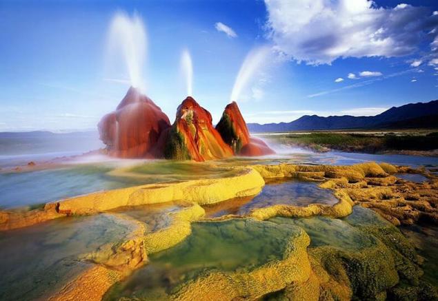
Geyser fly (Fly Geyser), which means a Soaring geyser — amazing geothermal geyser that is located approximately in 30 kilometers from city Gerlach (Gerlach) of Nevada, USA. The geyser is located at an altitude of 1230 meters above sea level, rainfall in the region is only 300 mm per year. The height of the geyser is about 1.5 m.
The valley of geysers is a canyon (gorge) up to a width of 4 km, depth 400 m and 8 km long, through which flows the river Geyser. Similar canyons in Kamchatka — tens, But is over 6 km from the mouth of the river there are more than 40 geysers and many hot springs, which are conventionally divided into 9 sections.
Tour of the ecological trail at this point passes through the Central part of the Valley of geysers, the so-called 5, 6, 7 thermal stations. Here you can see all known modern forms of hydrothermal activity including permanent and pulsating boiling springs, hot lakes, geysers, mud pots, mud volcanoes, steam jets, heated pad, adjacent compactly in a small space.
The valley of geysers it is impossible to perceive, to evaluate, to explore outside the complex and unique ecological system that has developed around hydrothermal springs. Unique community local thermal bacteria, algae, lichens, mosses, higher plants.
A combination of "normal" plots and intrazonal vegetation with substantial contributions from thermal cenoses have an impact on the local fauna. In this regard, not only photogenic Valley and a rare bio-ecological features of natural communities has led to increased interest in the Valley of geysers biologists of various specialties.
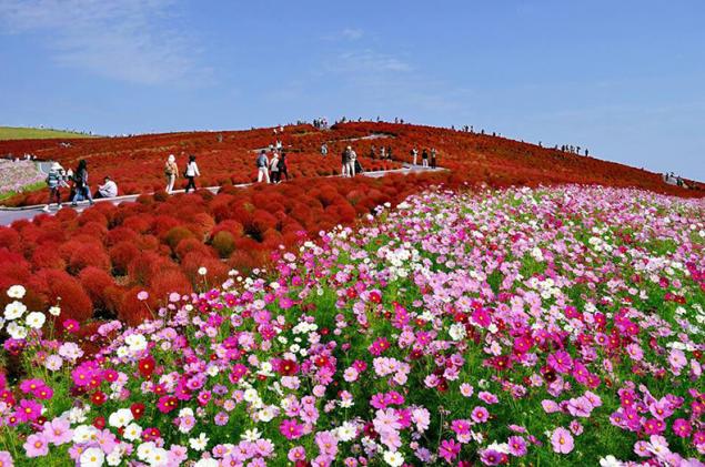
National seaside Park Hitachi (Hitachi Seaside Park, located in hitachinaka (Ibaraki Prefecture, Japan).
How prayer changes the blood
Why do we need energy and where to get it
A holiday that starts with the entry. One of the most beautiful places where I was able to see. A sea of flowers. incredible colors that shimmer in all shades of incredible range. To leave does not want, and after like I saw everything. published
Author: Katyagor Gorodnicheva
Put LIKES and share with your FRIENDS!
www.youtube.com/channel/UCXd71u0w04qcwk32c8kY2BA/videos
Subscribe — www.facebook.com//
P. S. And remember, just changing your mind — together we change the world! ©
Source: www.moya-planeta.ru/reports/view/samye_krasivye_mesta_na_planete_zemlya_23077/
Angel falls – the highest free-falling waterfall in the world. It is located in a mountain area of Guyana in Venezuela on the river Carrao, which is one of the tributaries of the Orinoco. In Spanish the name of the waterfall translates as "angel."
Since ancient times the local Indian tribes called the waterfall Churun-Measure ("Waterfall of the deepest place"), and a plateau from which it drops – Auyan-Tepui, which means "devil's mountain", because of the permanent thick fog that shrouded it.

The main attraction of Venezuela
In 1910, the waterfall was discovered by the Spanish Explorer Ernesto Sanchos La Cruz, but a world fame thanks to the American pilot and gold prospector James Crawford angel.
In 1949, the waterfall was dispatched an expedition of the National geographic society (USA), which determined the main parameters of angel. And in 1993 UNESCO made waterfall in the world heritage list of humanity. Now the angel is located on the territory of Canaima national Park and is considered the main attraction of Venezuela.
Waterfall surrounded by tropical forests and special roads for it ... Therefore, tourists are delivered to the angel through the air on a light aircraft or water in a canoe with a motor. The most desperate thrill-seekers can jump off the edge of the plateau on a hang glider. The starting point for tours to the waterfall is a small village Kunimi. With the influx of tourists the town has changed, there were few resorts, restaurants and souvenir shops.

The sondong cave in Central Vietnam, now bears the title of the largest caves in the world. It is located in the heart of the national Park Phong Nha Provides to Binh province, near the Vietnamese-Lao border. Its dimensions reach record levels – the height is 200 meters, width – 150 meters, length — more than 5 kilometers. Total unique education, over 38.5 million m3.
Lying in the depths of the jungle entrance to the cave was first found by a local resident named Ho Khanh in 1991, but wafting out the roar of the water flow and steep descent did not allow him to explore it from the inside. Only in 2009 a group of British scientists led by Howard Lamberton succeeded in Vietnam to detect and successfully explore Shandong, after which they announced the official opening of the cave and confirmed that the dimensions allow you to assign it the status of the biggest on the planet.
"Hang Sơn Đoòng" in Vietnamese means "mountain river cave". It really is an underground river with a rapid current, which floods the individual parts of Shandong during the rainy season. In addition it has its own jungle, the climate and even real clouds that are formed due to the large temperature difference. Two huge Windows of a giant underground cavity allow light to penetrate into its many parts, making grow inside a lush jungle with a 3-meter trees.
Shandong is famous not only for its impressive size, but also the best examples of cave formations on the planet. Here you can find interesting fossils, stalactites and some of the highest stalagmites in the world with a height of 70 meters. A particularly impressive formation is considered to be the "Hand dog" and the place called the Cactus Garden. Also in the cave there are examples of giant cave pearls, which is filled with limestone layers.
The flora and fauna of Shandong – a godsend for any scientist. In the caves there are many rare species of plants, and recently was even discovered several new species of animals. Monkeys, hornbills and flying foxes – they all live in an unusual underground jungle.
The unique cave was formed as a result of a long process of leaching of the limestone by water flow of about 2-5 million years ago.
In early August 2013 on a tour in Shandong went to the first tour group. To get inside the attractions, you must use the rope to go underground to a depth of 80 meters. Tourists break there a tent camp, spending time in the labyrinths of underground caves or cozy sitting by the fire. The cost of such entertainment is $ 3,000. In the period from September to March access to the cave is closed as it is the rainy season, during which many areas are flooded. Schedule for 2015 will be posted on the website, organise excursions at the end of this year.
The world's largest cave, Sơn Đoòng called attracting the attention of many film companies such as BBC, National Geographic, and the well-known Japanese and Brazilian teams. In 2011, she appeared on the pages of the popular magazine National Geographic.

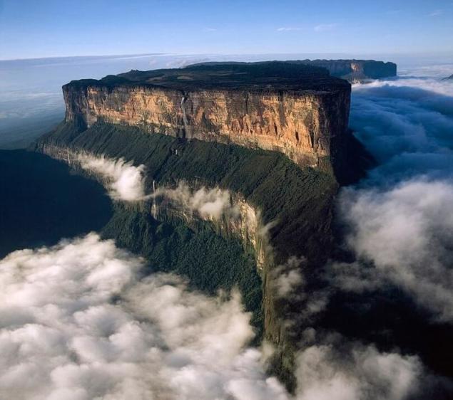
Mount Roraima is the most famous and concurrently the high Venezuelan tepui (table mountain), reaching a height of 2810 meters. It is located on the border of Brazil (state of Roraima), Venezuela (Canaima national Park), and Guyana (the highest point of the country). The surface area of the plateau of the “big blue-green mountain”, as it is called, is 30 km2.
The local Indians, in turn, called her "the navel of the earth" and believe that at the top of the mountain lives the goddess Queen is the mother of all people. Despite the fact that all tepui — it is the home of the gods, that Roraima is considered a Holy place. Almost always it is surrounded by whitish clouds, giving it a mystery that can not fail to attract adventurers, and admirers of beauty.
For a long time the most beautiful mountain of South America remained inaccessible and unknown. Only the bravest Indians overcame a difficult way to spell, according to their beliefs, the lands lying through almost impassable swamps and forests.
The first European Explorer who studied the area in 1835, was a German scientist Robert Shomburgk. He was struck by the majestic mountains with unique ecosystems, but attempts to climb one of them did not succeed.
Half a century later, in 1884, it managed to make two British scientists Everard Im Turnu and Harry Perkins, who conquered the top of mount Roraima, and revealed all the secrets of this mysterious terrain. It is on this route of modern travellers climb to the plateau of the famous Venezuelan tepui.
Written by pioneers of report on wonderful journeys to unexplored lands inspired by the famous writer Arthur Conan Doyle for creating the science fiction novel "the Lost world" about the discovery of the plateau, which was inhabited by prehistoric species of plants and animals.
Constant cloud cover around the mountain is associated with the fact that at the foot of Roraima rivers originate from the Amazon, Orinoco and Essequibo.
The surrounding scenery is really very similar to a fantasy world with black rocks, hung with threads of waterfalls, colorful ponds, wild vegetation and rare animals.
Almost the entire surface of the plateau mount black from "desert tan" and inhabiting the top layer of stone of microscopic algae. Only in those places where the Sandstone is not exposed to sun and rain regularly washed by the water, is his true color — hot pink.
Different the rate of destruction of layers of Sandstone contributed to the formation on the plateau of a large number of bizarre rocks. In some places the stone is cut through huge cracks into which several rivers fall, and later escaping from the rocks noisy waterfalls. Water covers about one-fifth plateau: peat bogs, hot pink puddle, crystal-clear lakes, rapid river, river bed for several hundred meters, dotted with crystal rhinestone.
The most colourful corners of the plateau are the moor – where there are beautiful flowers, exotic carnivorous plants, colorful carpets are full of silt and moss. The trees resemble bonsai represented a very small number of species.
The fauna of the plateau of Roraima also can boast of a rich variety, but it surprises with its unique representatives, most of which are endemic. Many of the inhabitants of the area painted in black, and even dragonflies and butterflies. Another plateau is home noshi, capybaras (capybara), mice, lizards, and several species of birds, spiders, predatory leeches and Scorpions.
SUBSCRIBE to OUR youtube channel that allows you to watch online, download from YouTube free video about the recovery, the rejuvenation of man. Love for others and ourselves, as the feeling of high vibrations — an important factor
The most amazing fauna of the plateau is a miniature, measuring about a centimeter, black toads, which tend to whistle before the rain. Each big tepui has its own special form of these frogs.
Mount Roraima has another unusual feature: it attracts numerous lightning, which is almost every day hit the surface of the top and very hard to find the tree is not affected by storm activity. Unearthly landscapes of the Venezuelan tepui inspired not only to write fantastic novels, but also on the creation of art, documentary and even animated films.
In 1993, the valley at the foot of mount Roraima served as the set for the famous sci-Fi movie "Jurassic Park", directed by Steven Spielberg.
In 2008 company Griffin productions was released informative documentary "the True Lost World", dedicated to mountain Roraima. He describes the exciting adventures of the team of researchers who followed in the footsteps of the first explorers of the peaks, Ima Turna and Harry Perkins.
The creators of the cartoon are also not deprived of attention of the famous Venezuelan mountain. In 2009, the film Studio Disney/Pixar released the animated film "Up" in which the action takes place in Roraima. On disc cartoon also features the short film "adventure's out there somewhere", a story about the journey of the team of Pixar to Roraima in search of creative ideas and inspiration to create the animated film "Up".
Today, mount Roraima rises every day a few dozen people. Climbing is usually done on the part of Venezuela, which owns three quarters of the mountain, since that side has the most gentle slope. The Venezuelan town from which to start the path to the Roraima called Santa Elena de uairén and lies near the Brazilian border.
To reach it, you have to first buy tickets to Caracas (capital of Venezuela) from Moscow with approximately ninety-minute transfers in Paris, Madrid or Rome. And from Caracas regularly ride the bus in the direction of Santa Elena de uairén. Alternatively, to this town can be reached by bus from Ciudad Bolivar.

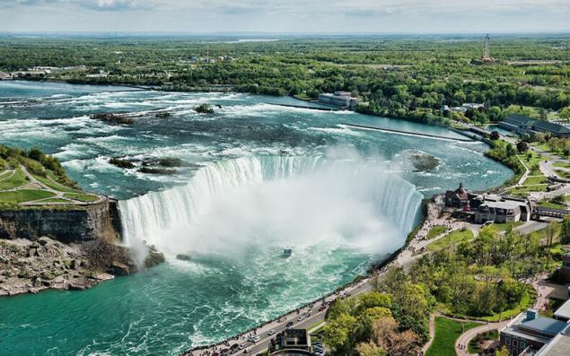
Niagara falls is fortunate to be situated on the border of the largest American States — the United States and Canada, which, naturally, contributed to making Niagara falls the most famous waterfall in the world, which annually attracts crowds of tourists. Although its parameters, for example, the height he is inferior to many other waterfalls, but the popularity and rasparennoe he can not refuse. The widest waterfall in the world it is not, but Niagara falls is the most powerful in North America by volume of water passing through it (about 5700 or more m3/s).
Niagara falls where the border of two Great lakes (Erie and Ontario), the actual consists of three separate waterfalls — the American falls Bridal Veil and the Horseshoe falls, frequently referred to as Canadian due to the fact that it is located on the territory of this country. The height of Niagara falls in American side is 51 meters, and the height of free fall of only 20 m due to the large number of rocks.
But it's pretty broad — 330 meters. But it does not compare with the impressive Horseshoe falls, whose width is due to a beautiful twist reaches 790 meters. The height of Niagara falls in the canadian — 49 meters. The canadian and American falls are separated by Goat island from viewing platforms, walkways, gift shops, and a monument to Nikola Tesla.
Third, the small waterfall is a waterfall Veil. It is quite narrow and is separated from the American small islet, called Silver island. Through the gorge through which flow the waters of Niagara, spanned by a beautiful rainbow bridge, built in 1941, and linking Canada and the United States.
An interesting event occurred in 1911, when, owing to an unprecedented frost of Niagara falls completely frozen over and turned into a huge block of ice, which was trying to climb the numerous tourists who came to see this amazing phenomenon.
The name Niagara comes from the old Iroquois word "Onguiaahra", which, as commonly understood, means "Thunder of water". The Western world learned about the existence of the waterfall by Explorer father Louis Hennepin, which is described by him in 1677 during one of his travels. A couple of centuries in response to the fashion for tourism Niagara falls has been actively visited, which led to the development of this district.
In particular, thanks to the efforts of Nikola Tesla power station was constructed. Today, Niagara falls continues to draw the crowds. The majority of visitors on the American side are Hindus. In recent years there was a mass influx of immigrants from India to Niagara falls, which is now filled with restaurants with Indian food, souvenir shops, etc.

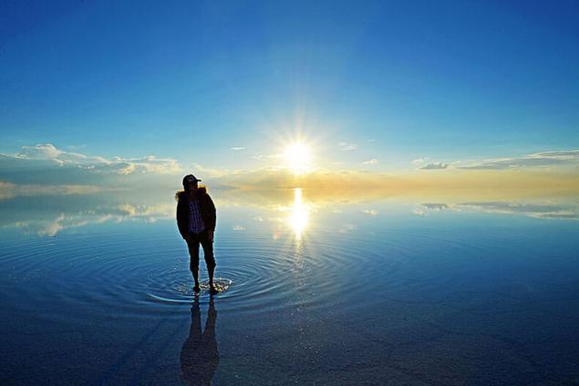
The world's largest dried salt lake. It's so much glitters and shimmers in the sun that hurts the eyes, so the sunglasses are indispensable.
In the rainy season, from November to March, the lake-Salar de Uyuni turns into a huge mirror: salt cell covered by a thin layer of transparent water which reflects the sky, and it becomes quite clear, where, in fact, the horizon.
Later a salt crust dries, and the water from the bottom breaks out due to this "salt eruption formed a small cone-shaped volcanoes.
In Salar de Uyuni frequent changes of temperature. The morning could be below zero, and during the day the desert is heated to +70 C.
Slicing through the desert on a jeep, it costs to get to the fishing island (Isla de Pescadores), where there are cacti, giant height from 8 meters and an age of 1200 years.
Another attraction of Uyuni salt flats – the Forest of stones. This is an unusual landscape with stone statues and sculptures, created not by man, but by wind and water. Postcards with the signature "Salar de Uyuni – Bolivia" will delight all your friends and family, at heart consider themselves archaeologists, explorers and artists in multiple disciplines.
On a trip to Salar de Uyuni you can spend the night in "salt" hotels in which sodium chloride is made even beds and tables.
After 3-4 day trip to the salt flat and Altiplano plateau (for a shorter period it is impossible to have time to look at all this beauty) can be enjoyed in the nearby town of Uyuni, famous for its cemetery of locomotives. Slowly (because of the dryness of the local climate) rusting cars lie near the railroad from Antofagasta to Bolivia since then, as they "dismissed" in 50-ies of XX century the extraction of minerals in these parts is greatly decreased, and the engines appeared to be irrelevant.

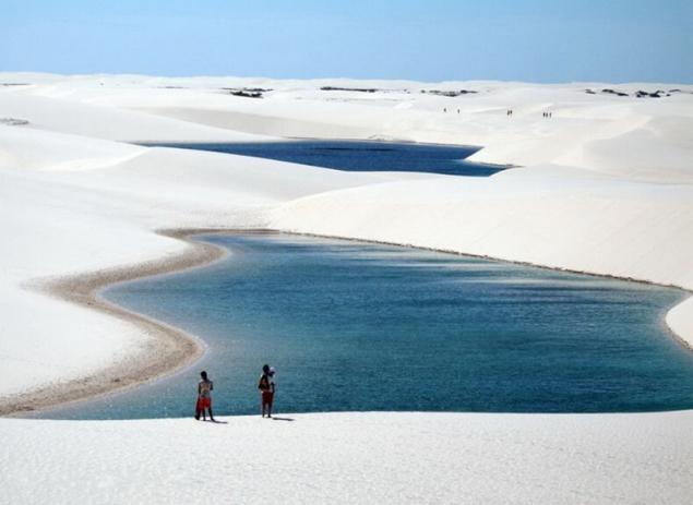
Unique national Park called "Lençóis Maranhenses" (Lencois Maranhenses) is located in the northeast of Brazil, state of Maranhao, known primarily for its Alcantara launch site.
What is the uniqueness of this nature reserve? It would seem that a seemingly ordinary desert. But with this experience and begin. In fact, you no desert. Rainfall here is hundreds of times more than most deserts.
All falling precipitation to form freshwater lakes between dunes of white sand. When is the rainy season, the desert comes alive here, and the birds. In lakes, of course, there are living organisms (fish, molluscs, amphibians, etc.). But the main attraction of Lençóis Maranhenses" (Lencois Maranhenses) is, of course, the magical combination of white sand and turquoise-blue clear water.

Geyser fly (Fly Geyser), which means a Soaring geyser — amazing geothermal geyser that is located approximately in 30 kilometers from city Gerlach (Gerlach) of Nevada, USA. The geyser is located at an altitude of 1230 meters above sea level, rainfall in the region is only 300 mm per year. The height of the geyser is about 1.5 m.
The valley of geysers is a canyon (gorge) up to a width of 4 km, depth 400 m and 8 km long, through which flows the river Geyser. Similar canyons in Kamchatka — tens, But is over 6 km from the mouth of the river there are more than 40 geysers and many hot springs, which are conventionally divided into 9 sections.
Tour of the ecological trail at this point passes through the Central part of the Valley of geysers, the so-called 5, 6, 7 thermal stations. Here you can see all known modern forms of hydrothermal activity including permanent and pulsating boiling springs, hot lakes, geysers, mud pots, mud volcanoes, steam jets, heated pad, adjacent compactly in a small space.
The valley of geysers it is impossible to perceive, to evaluate, to explore outside the complex and unique ecological system that has developed around hydrothermal springs. Unique community local thermal bacteria, algae, lichens, mosses, higher plants.
A combination of "normal" plots and intrazonal vegetation with substantial contributions from thermal cenoses have an impact on the local fauna. In this regard, not only photogenic Valley and a rare bio-ecological features of natural communities has led to increased interest in the Valley of geysers biologists of various specialties.

National seaside Park Hitachi (Hitachi Seaside Park, located in hitachinaka (Ibaraki Prefecture, Japan).
How prayer changes the blood
Why do we need energy and where to get it
A holiday that starts with the entry. One of the most beautiful places where I was able to see. A sea of flowers. incredible colors that shimmer in all shades of incredible range. To leave does not want, and after like I saw everything. published
Author: Katyagor Gorodnicheva
Put LIKES and share with your FRIENDS!
www.youtube.com/channel/UCXd71u0w04qcwk32c8kY2BA/videos
Subscribe — www.facebook.com//
P. S. And remember, just changing your mind — together we change the world! ©
Source: www.moya-planeta.ru/reports/view/samye_krasivye_mesta_na_planete_zemlya_23077/
Tags
life
travel
planet
youtube
econet.ru
watch online
download from YouTube
free
video
love
vibration
youtube.com
channel
facebook
See also
Life without a brain
Scientists about the brain: the best of TED talks with a Russian voice acting
Robert Waldinger What makes a good life? The lessons of the longest studies on happiness
In Argentina have found a meteorite weighing 30 tons
Comfort zone. In or out
When you change the world, and no one noticed
The most beautiful views of blooming rhododendrons for Your garden
10 of the most beautiful plants for sun beds
Instead of beauty and cats: what to watch on YouTube about science and culture