Morse on Martian dunes
 Bashny.Net
NEE NED ZB 6TNN DEIBEDH SIEFI EBEEE SSIEI ESEE SEEE !!
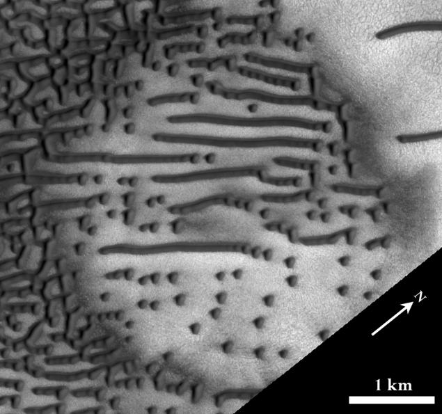
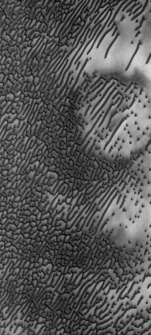
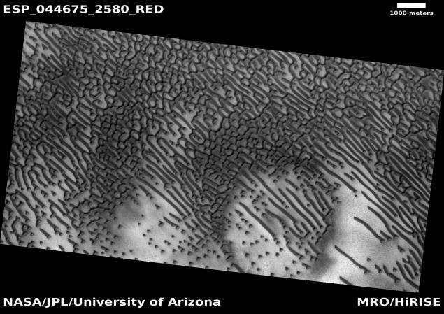
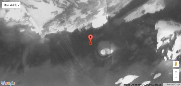
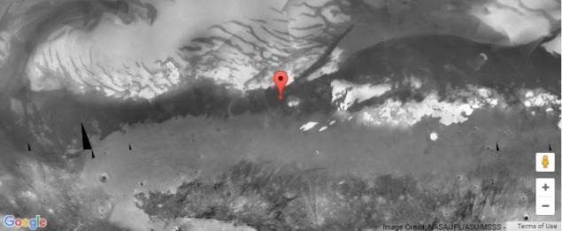
Camera High Resolution Imaging Science Experiment HiRISE, installed aboard the spacecraft Mars Reconnaissance Orbiter, took off really beautiful photograph of Martian sand dunes (photo ESP_044675_2580). Some of the dunes are like dots and dashes of Morse code.
NASA took advantage of a beautiful event to talk about the mechanism of formation of sand dunes on Mars.
The shape and orientation of the sand dunes used to say about the direction of the wind, but in this image form dunes is quite complicated, so that the exact direction of the wind is not easy to define. The shape of the dunes is also influenced by local topography, ie the topographical characteristics of the landscape.
Scientists explain that in this case there is a shortage of sand to form dunes due to the fact that the area is located in a depression in the shape of a circle - it's probably old, and already filled impact crater. This topography not only reduces the amount of available sand, but also affects the direction of the winds.
The Martian Morse code "dashes" - long linear dunes - shaped bidirectional winds, which do not run parallel to the dune. Instead, the combined effect of winds in two different directions by certain angles leads to the formation of such forms dunes, blowing out the sand material in the linear form.
The small "points" (dune-barhanoidy) are formed in places where, for whatever reason, the process of formation of linear dunes does not reach completion. At this time, scientists have not yet fully studied the mechanism - and this is one reason why the HiRISE camera takes images of the area
. The formation and migration of dunes on Mars - a hot topic for research because almost deserted and waterless area of the Red Planet is a great natural platform for such "experiments". In many ways, Martian dunes behave differently, not like the earth, due to the low density of the atmosphere.
If you still wonder exactly what is encoded in the "message" in the form of Martian dunes, the assessment specialist to restore the camera from NASA HiRISE Bray Veronica (Veronica Bray), transcript of dots and dashes corresponds to the following message:
NEE NED ZB 6TNN DEIBEDH SIEFI EBEEE SSIEI ESEE SEEE !!
(If the reptilians amongst us are willing to explain the meaning of the message, you can do so in the comments :)
Black-and-white photo
Black & White photo, Map Overlay
Photos in color model RGB, Map Overlay
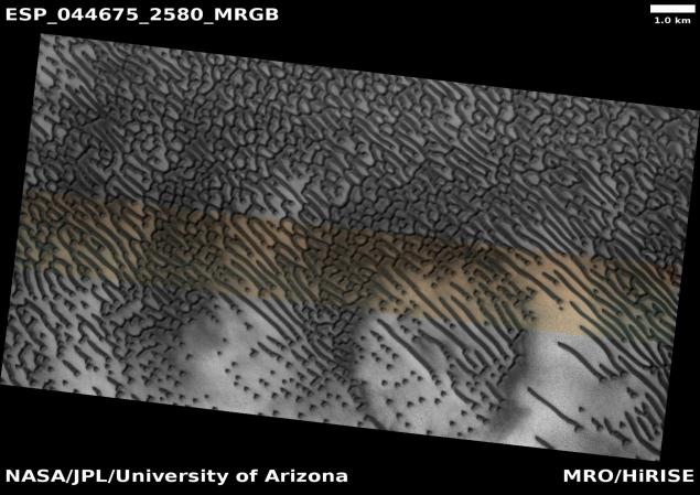
Photo in JP2 format black-and-white (1281 MB), color model the IRB (725 MB)
. HiRISE Camera 65 kg is a reflecting telescope with an aperture of 0, 5 m. This telescope is the largest telescope sent into deep space. Camera resolution is 30 cm per pixel when picked up at an altitude of 300 km above the surface of Mars. The width of the swath of up to 6 km. Camera successfully filmed rovers on the Martian surface, including the "Opportunity" and "Kyuriositi».
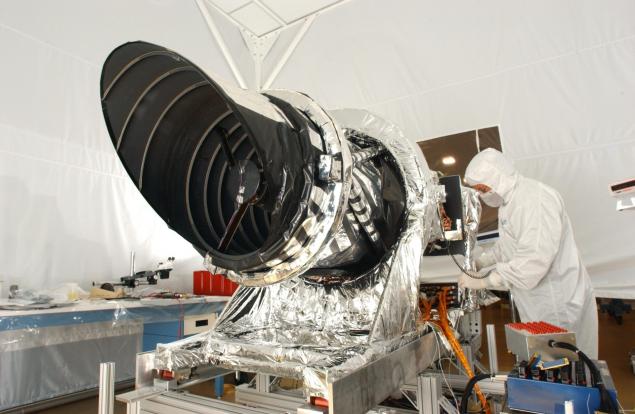
HiRISE camera before installing on the Mars Reconnaissance Orbiter
Features photos
The date of receipt: February 6, 2016
Local Martian time: 15:16
Latitude (photograph center): 77, 948 °
Longitude (east): 84, 005 °
distance to the object: 365, 9 km
original picture resolution: 36 6 cm / pixel (with 1 x 1 binning) so objects about the size of recorded 110 cm
card Resolution: 25 cm / pixel
map projection: polar stereographic projection
emission angle: 31, 7 °
phase angle: 36, 3 °
The angle of the sun fall: 58 °, while the sun rises about 32 ° above the horizon
< Solar longitude: 105, 4 °, the north summer
Context map of Mars, which is made satellite photo
The second photo of a stereo pair: ESP_045334_2580
Source: geektimes.ru/post/278314/

Camera High Resolution Imaging Science Experiment HiRISE, installed aboard the spacecraft Mars Reconnaissance Orbiter, took off really beautiful photograph of Martian sand dunes (photo ESP_044675_2580). Some of the dunes are like dots and dashes of Morse code.
NASA took advantage of a beautiful event to talk about the mechanism of formation of sand dunes on Mars.
The shape and orientation of the sand dunes used to say about the direction of the wind, but in this image form dunes is quite complicated, so that the exact direction of the wind is not easy to define. The shape of the dunes is also influenced by local topography, ie the topographical characteristics of the landscape.
Scientists explain that in this case there is a shortage of sand to form dunes due to the fact that the area is located in a depression in the shape of a circle - it's probably old, and already filled impact crater. This topography not only reduces the amount of available sand, but also affects the direction of the winds.
The Martian Morse code "dashes" - long linear dunes - shaped bidirectional winds, which do not run parallel to the dune. Instead, the combined effect of winds in two different directions by certain angles leads to the formation of such forms dunes, blowing out the sand material in the linear form.
The small "points" (dune-barhanoidy) are formed in places where, for whatever reason, the process of formation of linear dunes does not reach completion. At this time, scientists have not yet fully studied the mechanism - and this is one reason why the HiRISE camera takes images of the area
. The formation and migration of dunes on Mars - a hot topic for research because almost deserted and waterless area of the Red Planet is a great natural platform for such "experiments". In many ways, Martian dunes behave differently, not like the earth, due to the low density of the atmosphere.
If you still wonder exactly what is encoded in the "message" in the form of Martian dunes, the assessment specialist to restore the camera from NASA HiRISE Bray Veronica (Veronica Bray), transcript of dots and dashes corresponds to the following message:
NEE NED ZB 6TNN DEIBEDH SIEFI EBEEE SSIEI ESEE SEEE !!
(If the reptilians amongst us are willing to explain the meaning of the message, you can do so in the comments :)
Black-and-white photo

Black & White photo, Map Overlay

Photos in color model RGB, Map Overlay

Photo in JP2 format black-and-white (1281 MB), color model the IRB (725 MB)
. HiRISE Camera 65 kg is a reflecting telescope with an aperture of 0, 5 m. This telescope is the largest telescope sent into deep space. Camera resolution is 30 cm per pixel when picked up at an altitude of 300 km above the surface of Mars. The width of the swath of up to 6 km. Camera successfully filmed rovers on the Martian surface, including the "Opportunity" and "Kyuriositi».

HiRISE camera before installing on the Mars Reconnaissance Orbiter
Features photos
The date of receipt: February 6, 2016
Local Martian time: 15:16
Latitude (photograph center): 77, 948 °
Longitude (east): 84, 005 °
distance to the object: 365, 9 km
original picture resolution: 36 6 cm / pixel (with 1 x 1 binning) so objects about the size of recorded 110 cm
card Resolution: 25 cm / pixel
map projection: polar stereographic projection
emission angle: 31, 7 °
phase angle: 36, 3 °
The angle of the sun fall: 58 °, while the sun rises about 32 ° above the horizon
< Solar longitude: 105, 4 °, the north summer
Context map of Mars, which is made satellite photo


The second photo of a stereo pair: ESP_045334_2580
Source: geektimes.ru/post/278314/
Tags
See also
Top photo on the space theme for 2011
Top photo on the space theme for the year 2011 (32 photos)
Indian spacecraft Mangalyaan successfully arrived in orbit of Mars
Nokia ringtone carries a hidden message encoded using Morse code
MRO orbiter photographed Curiosity from orbit
On the outer heat and cold
5 strange modern space projects
13 amazing facts about the ocean depths
Gorgeous view of Mars from NASA
What do we know about Mars?