Meteorologists have found the ocean's ability to predict extreme heat 50 days before its arrival on the mainland
 Bashny.Net
Meteorologists from the National Center for Atmospheric Research USA (National Center for Atmospheric Research, NCAR) tied the formation of characteristic structures on the thermal map of the Pacific Ocean with periods of unusual heat waves on the east coast of the USA. These phenomena can predict the next rise in temperature over the 50 days prior to their occurrence.
The task of weather forecasting is extremely difficult, because the atmospheric phenomena governed by the laws of nonlinear dynamical systems subject to dynamic chaos. The final state of the system is highly dependent on the initial parameters, and at the slightest change in them varies greatly. A well-known example of the description of the behavior of such systems is the "butterfly effect".
Modern meteorology using supercomputers can count more or less reliable forecasts for periods up to 5-7 days. Medium-term forecasts (up to 10 days) on average are justified on 65-80%.
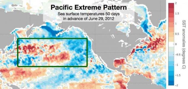
Analyzing data from weather satellites, scientists have discovered that appear in portions of the Pacific Ocean with a very strong contrast of the surface water temperature is often preceded by increases in temperature on the coast. The appearance of certain images on a map of the temperature increases the probability of occurrence of extreme heat after a certain number of days, three times.
"Summer heat waves - one of the most dangerous natural phenomena that have a strong influence on the work of farmers, energy industry and other important aspects of society - explains Karen McKinnon [Karen McKinnon], a researcher at NCAR and lead author of the work. - If we can prevent the municipal authorities and farmers on the approximation of the extreme temperatures, we can avoid the very serious consequences »
.
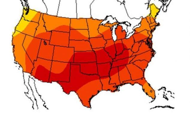
June 29, 2012 was the hottest day for the United States in the history of the East
Looking dependencies between the intense heat in the eastern states and the state of the world's oceans, scientists stumbled upon a characteristic pattern - extreme temperatures on the continent is usually preceded by the appearance of a particular image in one of the locations of the Pacific Ocean, about 20 degrees north latitude
. Testing took place according to the processing of data collected in 1613 weather stations from 1982 to 2015. Considered extremely hot days when the temperature rose more than 6, 5 C above average. Scientists took into account the heat in the summer from 24 June to 22 August.
The resulting temperature at the ocean surface patterns were able to predict the week of extreme heat 50 days prior to its occurrence, and the particular day this week - 30 days prior to his arrival. While scientists find it difficult to say exactly which mechanisms lead to the emergence of such an unusual dependence.
The first ever weather forecast appeared August 1, 1861 in The Times newspaper, authored by Robert Fitzroy - an officer of the Navy of Great Britain, the commander of the "Beagle" expedition ship, which was attended by Charles Darwin, the Governor-General of New Zealand, the founder and head of the Meteorological Department . Subsequently, due to malfunctioning of its forecasts, he committed suicide.
Source: geektimes.ru/post/273482/
Tags
See also
Giant's Causeway
Psychedelic paintings by science
15 most expensive space projects and missions
Seymour Cray and his car
The differences in the education of the "wild" tribes and the "civilized" society from birth. Part 1
Small volcanoes can cause cooling of the climate
Where they filmed the cult movie
A good movie - always an excuse to travel, even in the imagination.