In 2015 marks 200 years since the first large-scale geological map
 Bashny.Net
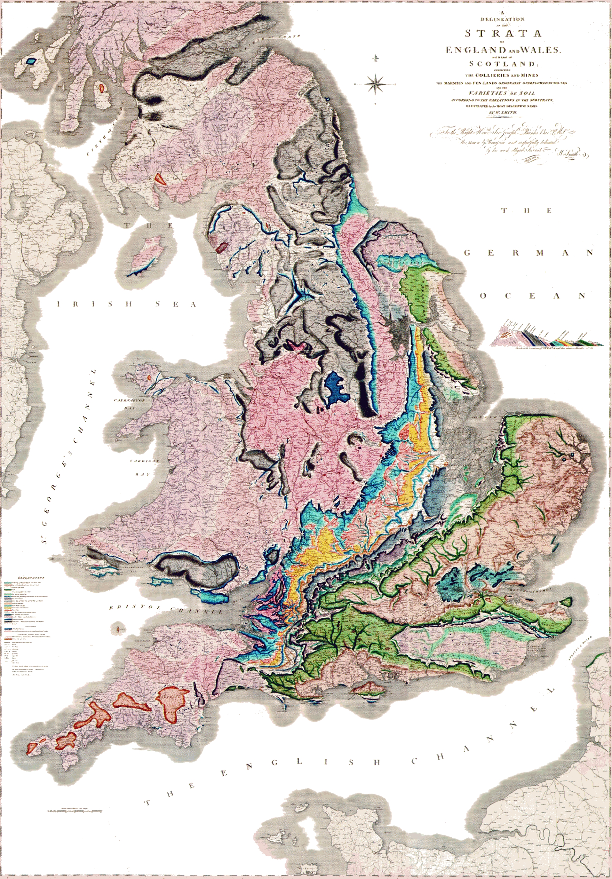
The first large-scale geological map - clickable i>
This year исполняется 200 years since the events , defined the modern geology: William Smith, English geologist, in 1815 published the first large-scale geological map, which has been applied all of England, Wales and part of Scotland. His card contains an ordered mountain formations, isolated on fossils they contain.
It was not the first geological map. When people learned to extract minerals and draw maps of the area, it was obvious to map minerals deposits. Before our time from the 12th century BC, the ancient Egyptian papyrus reached «Туринская papyrus map », which depicts a 15-kilometer stretch of the Nile near the bed, indicating villages, hills, gold mines and quarries, as well as the distances between them.
Closer to our times, in 1683, Martin Lister suggested the Royal Society on the chart indicates the soil and minerals. This point is considered the birth of the geological survey and geological maps. However, the first large-scale map published still Mr. Smith in 1815.
Smith was not a bored rich aristocrat or a geologist by training. He supervised the construction of canals and drainage facilities. And in the process, he drew attention to the fact that the geological formations on the earth's surface are not arranged randomly. They are divided into layers in sequence, and the order is maintained throughout the country. He also realized that fossils can be used as an indicator of the age of the layers. About Will Smith's written many books, the most famous of which - « The Map That Changed The World ».
Interested in geological map of Russia can easily find them on the Internet - here, for example, site with scans cards , sayt with pdf , and site interactive map .
Source: geektimes.ru/post/244760/
Tags
See also
14 most anticipated gadgets of 2015
Tesla sets titanium shield and aluminum bumpers on the bottom of Model S
The evolution of smartphones. Part 2: 2011 - 2015
The General theory of relativity this year marks 100 years
Oktoberfest 200 years (26 photos)
Uzbekistan. The ships of the desert.
Standard kilogram celebrated 125 years
20 of the most anticipated films of 2015
Tesla in 2016 plans to sell electric drives larger than the entire volume of the US market in 2015