Applied dronokartografiya
 Bashny.Net
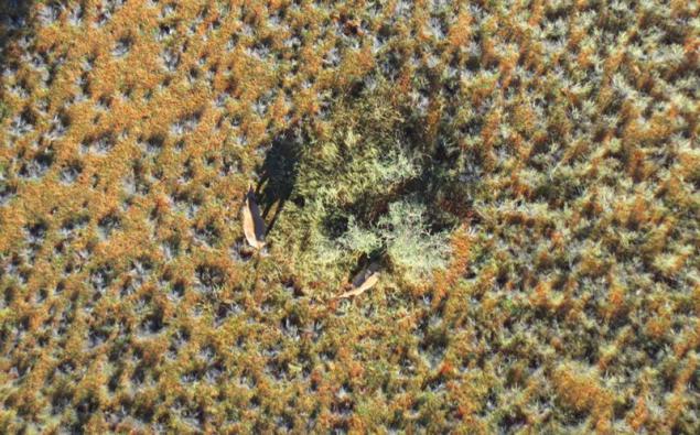
Two rhino in the national reserve Kuzikus (Kuzikus), Namibia. I>
C rapid development of modern cartography drones got a great tool to create very detailed maps of small areas of land, from a few tens or hundreds of square kilometers to individual households. This greatly cheaper than using airplanes or satellites, and can achieve a very high degree of detail. On the use of drones for aerial terrain today already built many businesses around the world. For example, when the US military needed to map minefields in one of the valleys in Afghanistan, helped them in this Tudor Thomas (Tudor Thomas), a specialist in aerial photography. Under his leadership was established aviation system for mapping, which in 2013 cost the US Army and its contractors from one to five million dollars. And here was not included the cost of the aircraft. But still there was something to do, let's say, a few photos from the air.
Because of this history, Thomas was born the idea for the business - mapping using drones. Customers could rent or buy a drone to spend with the help of photography. Though I must admit that at that time the idea could not be called innovation, all over the world, many entrepreneurs have earned this way.
However, Thomas and his colleagues decided to go ahead and set up the software that "glues" the images taken from different points in the overall map. Created on the basis of cloud computing system corrects photos so that they seemed to be made from the same angle, this process is called orthorectification. If you can pinpoint GPS-coordinates of any reference points on the ground, then a separate software allows you to create a map of spatially referenced.
Thomas called his project Maps Made Easy and successfully collected the necessary funds to Kickstarter. Clients appeared immediately, mostly land owners, but quite a few people just passionate cartography. Many are attracted to this project an opportunity to get cheap very detailed photocard your site, because in the same Google Maps data are often updated every few years, and the maximum resolution is very small by today's standards. With the help of drones can create a map with details about 20-fold higher than that of Google Earth. Moreover, the company now offers not just Thomas photomaps, but also creates a three-dimensional models of them.
Moore's law against aerial h4> The geologist Larry Hulbert (Larry Hulbert) using Maps Made Easy made a map of the territory where he conducted research in order to find a nickel, copper or platinum. The photos were taken pictures, but to build them into a single image Hulbert took advantage of a software tool MME. The result is a narrow card 7 to 0, 3 km (2, 1 sq. Km.) Cost $ 44. However, here you need to include the cost of renting a helicopter with a pilot - $ 1,800 per hour. As a result, spent a couple of hours shooting money could buy your own excellent drone.

Dronogumanizm h4> Another example illustrates the benefits of using drones is the story of Patrick Meier (Patrick Meier), Director of Social Innovation at the Qatar Computing Research Institute. Commissioned by Meyer, on a national reserve Kuzikus in Namibia was conducted 90 flights in search of black rhinos from the brink of extinction, as well as other animals. Due to mass poaching, spurs demand for rhino tusks, these animals now have about 29,000 (in 1970 there were 70,000, and in 1900 - 500,000).
At first glance, the drones have proved very useful tool, because with their help you can quickly scan large areas and inform the Rangers, where to look for rhinos. However, researchers faced with another problem - how to view a 25,000 pictures to find rhinos?
To solve this problem, Meyer has attracted volunteers who were to view photos and trace frames found animals. Participation in this crowdsourcing project took about 500 people from around the world, and they are all for two days treated with 98% of the shots. Meyer also is negotiating with the University of Lausanne, Switzerland, on the use of artificial intelligence algorithms to automate the processing of photos. In particular, to assess the damage caused to coconut plantations after the storm in the Philippines.
Experts around the world are welcome to use drones for specific tasks of search and evaluation, as taken with them photos have higher resolution, less expensive and can be obtained much faster and easier.
Where buried the body? H4> 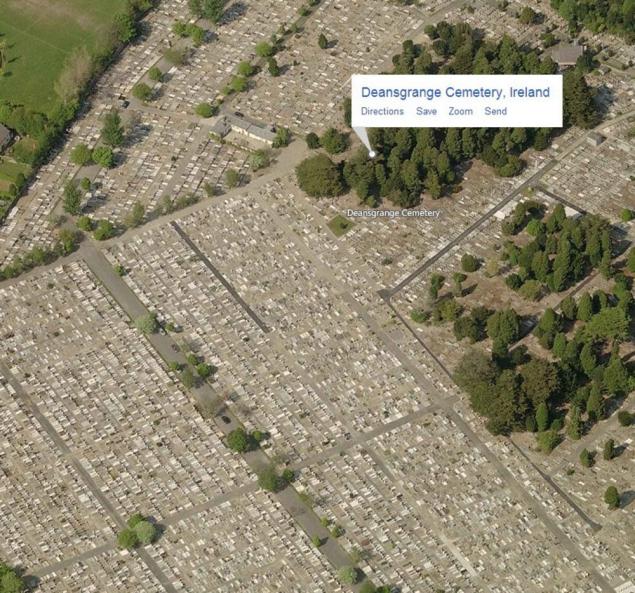
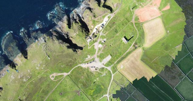
Cemetery Dinsgranzh (Deansgrange), Ireland. I>
Another example of the use of drones for more information about a certain territory - cemetery in Northern Ireland. Many large cemetery in the planning of its territory under the new burial is usually guided by the documents and plans, which for decades. This often leads to errors and linings. When we are talking about thousands of sites, inevitably there are situations when its outstanding free sites are occupied, and vice versa.
As a result, managers cemetery Dinsgranzh resorted to the services of the drone and created a current map of the whole territory with the precise, whether occupied by each site, and by whom. Previously, to update the data on 12 acres of the cemetery took about 100 hours: it was necessary to mention GPS-coordinates of each site occupied. Drone solved this problem for about two hours. It was enough to bind multiple control points, all plots were placed in the automatic mode. Then each site were compared to data buried.

Conclusion h4> Examples of the use of drones for such a "point" of cartography can be cited. For example, they can be used to assess the situation on some disputed territory. Or make-to-date map of difficult terrain, to assess the impact of natural disasters, to get an accurate picture of the state of the acquired land, delimit the river floods, and so on and so forth. Considering the active development and reduce the cost base, - drones - we can assume that in the next few years the market will be mapping software adapted for use with images from drones. Maybe it already exists, and if you are aware of such, tell us in the comments. I'm sure many will be interesting and useful to this information.
Source: geektimes.ru/company/airbnb/blog/244274/
Tags
See also
Game of Drones. As the men were breaking each other quadrocopter
Small aircraft, flying drones, IT and my dream ...
Drones for movies
Toys for older children - Review of Parrot Bebop Drone
Natural wonder of Ukraine: Podilski Tovtry
Photos from National Geographic
Arches National Park (Arches National Park)
Chinese rock garden
Etosha National Park in Namibia (13 photos)
3D-printer, glasses virualnymi reality and quadrocopter seized the territory TechTrends Expo 2015