Earth through the eyes of a satellite
 Bashny.Net
I present to you some amazing pictures from space that show the geographical features of the Earth and the unpredictability of nature.
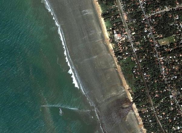
Coast of Sri Lanka, 26.12.2004.
Ocean quickly moves back to 400 m. In the south-eastern coast of Sri Lanka - in just 5 minutes before the devastating tsunami.
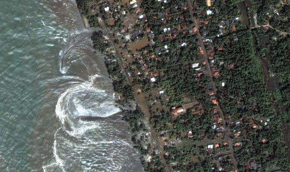
Rushing water beating against the shore - just a few moments before hitting the main wall of water.
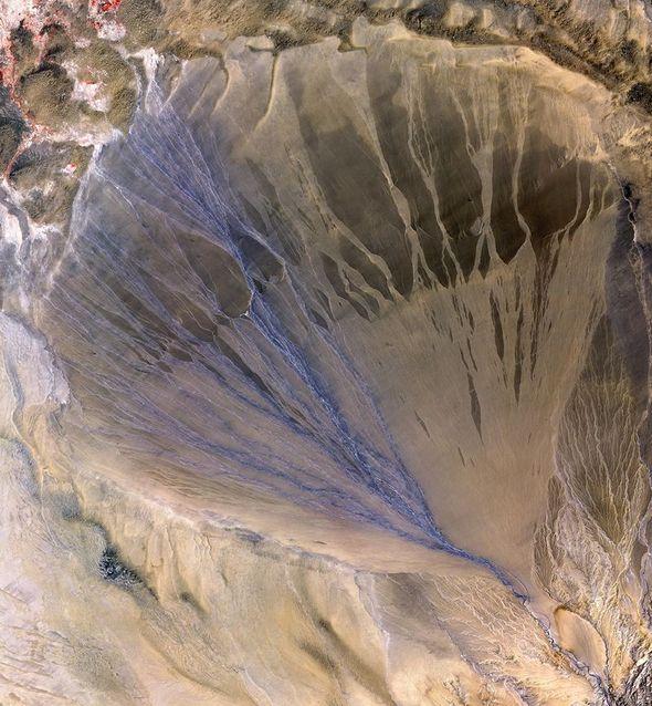
Alluvial fan, Province of Xinjiang, China This photo taken 02/05/2002, shows a fan alluvial deposits formed on the southern border of the Chinese desert Taklimakan. Normally, such a fan is formed when water is drained out of the canyon, and each new stream eventually becomes clogged due to sludge. As a result, a triangle of active and inactive channels. Blue channels on the left - are active.
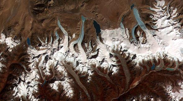
Retreating glaciers in the Bhutan Himalayas. Beautiful and clear evidence that glaciers slowly melting due to global warming. Easily distinguishable edge of glacial valleys, into water, and forming a lake - a trend was noticed only in the past few decades.
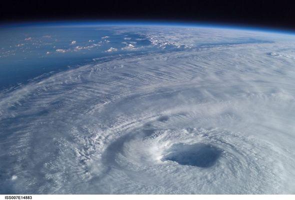
Cyclone Isabella, 2003 Appalling Photo cyclone Isabella received from the International Space Station in 2003, demonstrates the enormous size of his eyes. This was the strongest cyclone in 2003, it reached a speed of 165 miles / hour (~ 265 km / h).
The east coast of Greenland, 21.08.2003. Fractal Greenland coastline with many inlets - view from space. Small white spots in the water, apparently, are the ice came from a deep fjords that extend up to the glacier that covers most of the island.

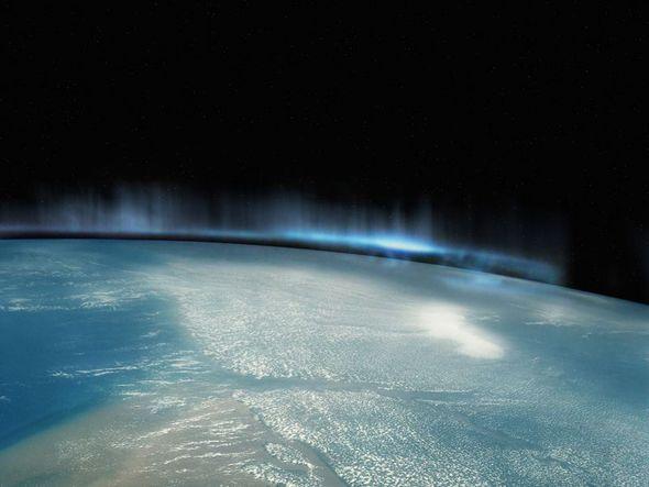
Aurora. Amazing and terrifying picture natural phenomenon known as the "aurora". The photo was taken from the shuttle Atlantis during the STS-117 expedition.
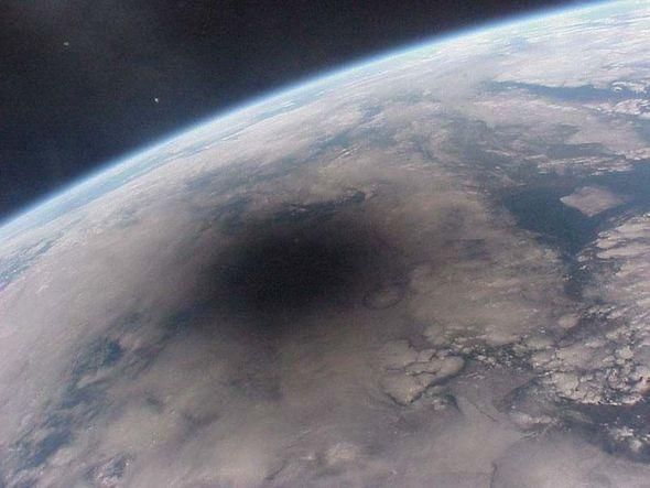
The total solar eclipse, 1999. In this photo taken on August 11, 1999 on board the Mir space station, you can see how the Earth casts a shadow on the moon. This shadow swept across the planet at a speed of 2000 km / h. All that was provided in its center, is plunged into darkness. It was probably one of the last pictures taken on the world.
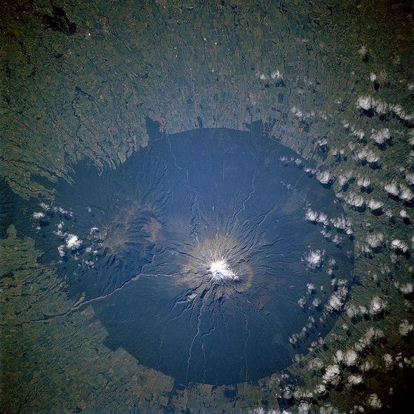
Reserve Egmont, New Zealand. Last eruption occurred Egmont in 1755, and now he is in the center of the reserve Egmont. The reserve was created to ensure the preservation of forests within a radius of 9, 5 km. from the top of the volcano, from space looks like a huge dark green disc. The picture was taken during an expedition STS-110 in April 2002
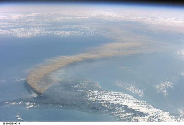
The eruption of Mount Etna in October 2001. In the picture, taken in 2001 with the International Space Station is seen strong volcanic eruption on the island. Sicily, which was formed as a result of the ash cloud has reached Libya. On a large picture near the volcano is visible lighter smoke, which was formed due to the fact that the lava ignited nearby forest.
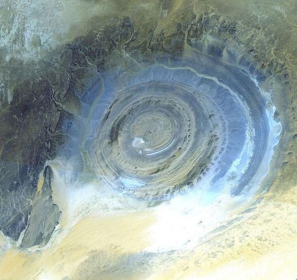
Richat Structure, Mauritania. It has been much debate as to the cause of the structure Richat located in the Sahara Desert in Mauritania. First, because of the round shape, it was thought that this - the crater caused by the fall of a meteor. But then, this version was rejected, as was found near the corresponding traces of impact. Now it is believed that this huge contraption (~ 48 km. In diameter) is a stone dome, formed due to erosion. The image was taken using the latest space Radiometer (Aster) October 7, 2000
via
Coast of Sri Lanka, 26.12.2004.
Ocean quickly moves back to 400 m. In the south-eastern coast of Sri Lanka - in just 5 minutes before the devastating tsunami.
Rushing water beating against the shore - just a few moments before hitting the main wall of water.


Alluvial fan, Province of Xinjiang, China This photo taken 02/05/2002, shows a fan alluvial deposits formed on the southern border of the Chinese desert Taklimakan. Normally, such a fan is formed when water is drained out of the canyon, and each new stream eventually becomes clogged due to sludge. As a result, a triangle of active and inactive channels. Blue channels on the left - are active.

Retreating glaciers in the Bhutan Himalayas. Beautiful and clear evidence that glaciers slowly melting due to global warming. Easily distinguishable edge of glacial valleys, into water, and forming a lake - a trend was noticed only in the past few decades.

Cyclone Isabella, 2003 Appalling Photo cyclone Isabella received from the International Space Station in 2003, demonstrates the enormous size of his eyes. This was the strongest cyclone in 2003, it reached a speed of 165 miles / hour (~ 265 km / h).

The east coast of Greenland, 21.08.2003. Fractal Greenland coastline with many inlets - view from space. Small white spots in the water, apparently, are the ice came from a deep fjords that extend up to the glacier that covers most of the island.

Aurora. Amazing and terrifying picture natural phenomenon known as the "aurora". The photo was taken from the shuttle Atlantis during the STS-117 expedition.

The total solar eclipse, 1999. In this photo taken on August 11, 1999 on board the Mir space station, you can see how the Earth casts a shadow on the moon. This shadow swept across the planet at a speed of 2000 km / h. All that was provided in its center, is plunged into darkness. It was probably one of the last pictures taken on the world.

Reserve Egmont, New Zealand. Last eruption occurred Egmont in 1755, and now he is in the center of the reserve Egmont. The reserve was created to ensure the preservation of forests within a radius of 9, 5 km. from the top of the volcano, from space looks like a huge dark green disc. The picture was taken during an expedition STS-110 in April 2002

The eruption of Mount Etna in October 2001. In the picture, taken in 2001 with the International Space Station is seen strong volcanic eruption on the island. Sicily, which was formed as a result of the ash cloud has reached Libya. On a large picture near the volcano is visible lighter smoke, which was formed due to the fact that the lava ignited nearby forest.

Richat Structure, Mauritania. It has been much debate as to the cause of the structure Richat located in the Sahara Desert in Mauritania. First, because of the round shape, it was thought that this - the crater caused by the fall of a meteor. But then, this version was rejected, as was found near the corresponding traces of impact. Now it is believed that this huge contraption (~ 48 km. In diameter) is a stone dome, formed due to erosion. The image was taken using the latest space Radiometer (Aster) October 7, 2000

via
Tags
See also
The most beautiful pictures of the cosmos September 2012go
Kosmos.
25 pictures, from which the soul goes to the heel
Ten of the most dangerous cities in the world
The most interesting announcements of CES 2015
25 photos, which will have to look twice
23 pictures that are hard to believe
20 pictures, after which you'll love the snow
Symptoms of a quantum transition, transmutation and ascension. Most Recent:
20 photographs doctored, who believed in the Whole World