Assessing the potential of renewable energy sources. Regional experience
 Bashny.Net

This post is dedicated to the presentation of the results to assess the potential of renewable energy sources (RES) on the example of Tomsk region. As a basis for assessing the potential results of the monitoring are taken based on actual data on the results of the expert groups. The authors of the project is based geo-information system using technologies Google.
The purpose of the geographic information system h4> Tomsk region has a number of areas not serviced by centralized power. To provide the population with energy used diesel, coal or oil-fired stations. This fact leads to a substantial increase in tariffs, which in some settlements of the Tomsk region reaches 90-110 rubles per kilowatt. In this social tariff does not exceed 4 rubles per kilowatt, and the difference in tariffs cover the regional budget. However, part of the district of the Tomsk region, there are prospects for the introduction of alternative energy sources. In order to create a geographic information system (GIS) is a compilation of information on production and consumption of heat and electricity in the Tomsk region, as well as the potential replacement of solid and liquid hydrocarbon fuels (oil, fuel oil, diesel, coal) on regional fossil fuel (biogas, waste logging, forest products, peat) and renewable energy sources (wind, solar stations, geothermal).
The study area h4> GIS is based on the example of Tomsk region. Tomsk Region is located in the southeastern part of the West Siberian Plain, part of the Siberian Federal District. The area is bordered in the north - with the Khanty-Mansi Autonomous District, in the east - with Krasnoyarsk region, in the south - Kemerovo and Novosibirsk region, in the west - with the Omsk region.
Territory area - 316, 9 thousand sq. M. km. (1, 5% greater than the area of Poland)
The population of the Tomsk region on January 1, 2013 amounted to 1064, 2 thous. People (0, 74% of the population of the Russian Federation), the average population density - 3, 4 persons per square kilometer. km.
Features of the nature and climate 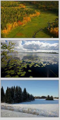
The region consists of 4 urban districts (Tomsk, Strezhevoi, pine, Seversk), 16 municipal districts, including 6 city (Tomsk, Strezhevoi, pine, Seversk, Asino, Kolpashevo) and 116 rural settlements, urban village 1 (n . Bely Yar) and 579 rural settlements. The regional center - the city of Tomsk. The relief area is extremely evenness. The highest point of the Tomsk region, 274 meters from sea level. The lowest point is 34 m above sea level. Most of the territory is covered by forests, swamps, rivers and lakes. The major rivers - the Ob, Tom, Chulym, Ket, Vasyugan, Tym. The entire river system belongs to the basin of the Ob, which crosses the region from the southeast to the northwest at a distance of about 1,000 kilometers, dividing the area into two almost equal parts. Number of lakes in the Tomsk region reaches 95 000, especially a lot of them in floodplains. The largest lake in the Tomsk Region - Peaceful Lake is located on the flat area between the rivers and Chuzikskiy Chizhapka. In total there are 573 rivers. Type of climate is continental. Winter is long and severe. The average January temperature of -19 ° C to -21 ° C. Summers are warm, short. The average July temperature of +17 ° C to +19 ° C. 450-700 mm of precipitation per year. The growing period is about 125 days. Located in areas of middle and southern taiga and mixed forests in part. Soils are mainly sod-podzolic and peat bog, in the southeast of the gray forest. Forests (the main species: birch, pine, cedar, aspen, fir, spruce) cover about 54% of the territory. The region is rich in natural resources such as oil, gas, iron ore, peat, brown coal.
One of the most valuable natural resources of the Tomsk region is forest. Timber reserves account for 2, 8 billion cubic meters. m.
Major highways are located in the southern part of the region with access to the neighboring regions. The total length of roads with hard surface is 6278 km.

GIS and symbols h4> 
Geothermal water - geothermal waters are called water with a temperature above 20 ° C, located in the bowels of the Earth. In most cases, they have a temperature of 40 - 100 ° C and above. Relate to energy sources that are used as renewable energy sources for heat and / or electricity.

Hybrid vetrosolnechnye station - systems that include wind turbines, solar panels and a redundant power supply optional

DEL - Diesel power (diesel generator set, diesel generator) - fixed or mobile power plant, equipped with one or more electric generators powered by diesel internal combustion engine.

Boiler fuel oil - a building or room with the boiler (heat generator) and auxiliary equipment designed to produce heat, which is a resource for fuel: diesel fuel; fuel oil; crude oil.

Boilers for solid fuels - a building or room with the boiler (heat generator) and auxiliary equipment designed to produce heat, which is a fuel resource: wood chips; firewood; coal.

What's livestock - farmers with cattle-cattle (in the geographic information system specified with a livestock farm of more than 500 heads). Wastes from the production are treated as biological resources for obtaining biogas .

Sewage treatment plant - complex engineering structures settlement designed for wastewater treatment of contaminants contained therein. Waste treatment facilities may be considered as a resource for the production of biogas.

Breweries and food industry - the enterprise with high waste from the food industry. Wastes from the production are considered as raw material for the production of biogas.

MSW landfill - the place of accumulation of solid waste (items or goods lost consumer properties) of human life. Considered as placement resources for production of landfill gas (due to gas gathering, resulting in the natural biodegradation of organic waste), as well as biogas and for recycling and utilization.

Poultry The enterprises poultry industry Tomsk region. Wastes from the production are considered as raw material for the production of biogas.

Districts logging - areas where logging activities conducted, consisting of a set of logging operations and timber hauling.

pig farm - the enterprise, designed for the complete technological cycle - from reproduction to the slaughter and processing of meat pigs. Wastes from the production are considered as raw material for the production of biogas.

Thermal power plants - large station Tomsk region, generates electric power by converting chemical energy into mechanical energy of rotation of the shaft to give an electric heat.

The peat lands drained - The peat deposit from the surface to the bottom or to the mineral deposits sapropel consists usually of several types of peat conducted with complex hydraulic engineering measures to create a drainage system and with different degrees of readiness for the start of peat extraction.

Peat deposits (for the development of promising energy purposes) - peat deposit with a low ash content of 15% and a large supply of peat, such deposits may be involved in the operation in a short time because of the relative transport availability and location near settlements.
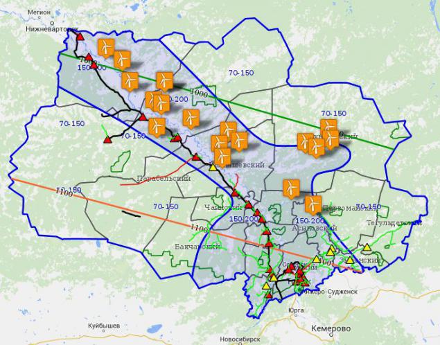
GIS includes изолинии wind, sun contours, road map, existing gas pipelines, power transmission lines (if necessary). All objects are geo-referenced and detailed description. Description includes public information about generation or expert opinion on the potential of renewable energy. As used GIS technology Google. View GIS is presented in the figure.
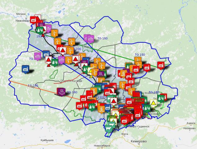
GIS is built "in layers." You can temporarily disable any or layers and work with information, for example, on the peat deposits.
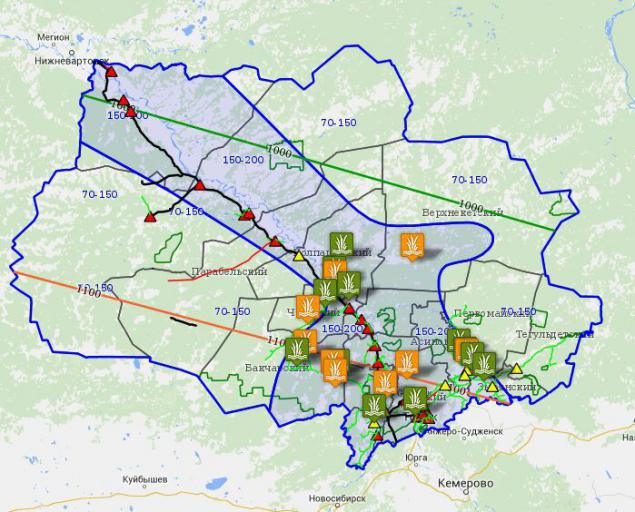
It is possible to combine layers, thereby evaluate logistic capabilities and convenient placement of the object potential generating alternative fuel based fuel corresponding resource (sawdust, peat, wood chips, biomass, etc.).


Reasons for entering information into a GIS h4> The main objective of this work to get the most reliable data on the potential of renewable energy sources and the most updated information about the objects of the generation. In this regard, data from at least several independent sources or data expert advice directly on the objects. For this group of experts were formed, which were sent to the areas of the Tomsk region. Also in the GIS were used
1. These regional reports on the objects generating
2. Trends multiyear meteorological observations
3. Environmental studies territory
4. Scientific data on the publications of independent research groups research institutes and universities of Tomsk and Russia
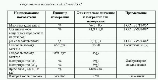
5. Laboratory studies of biomass of different origin (manure, brewer's grain, sewage treatment plants)
6. Results geologorazvetki different years for the application of information on peat deposits. I>
This approach allowed us to obtain a GIS with a high degree of validation. For example, we can see that these expert opinions on the potential energy vetrosolnechnoy perfectly fit the contours of the wind steadily formed over many years of weather observations (shown sustained wind contours are plotted with blue lines in the center)

Example expert opinion h4> Consider a more detailed example of the work of the expert group. To get the actual data from the enterprises were formed an expert group of 2-3 people with appropriate expertise. Also used for special laboratory facilities to conduct additional studies of samples of raw materials. As I headed one of the groups of experts - will describe in more detail the methodology of the specialists of our destinations.
In our work of the expert group were evaluable
1. Enterprises agricultural profile
2. Poultry
3. Svinokompleks
4. brewery i>
Partially experts worked on assessing the potential treatment plants. Subject assessment - biomass and biowaste production of these enterprises. All groups of experts working on the basis of a written request to the owners (or senior executives) enterprises which (surprisingly) actively promote the work of specialists.
Regulate the work of experts методики the work of experts, which include all the necessary steps and manipulations. Each expert group had
1. Samples of documents to fill in the form опросных sheets .
2. The camera is configured to automatic withdrawal date and time
3. GPS, voice recorder
4. Containers for biomass sampling for laboratory tests
5. Additional materials (bags, tags, tightening, disposable gloves, sampling intakes, markers) i>
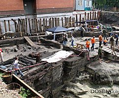
The task of the expert was clearly filling the information in the questionnaire, familiarity with the enterprise, process, waste management systems, slaughterhouses, etc. in accordance with the algorithm of action expert. All actions are clearly defined, so there had been no significant faults and shortcomings. Were photographed and the calculation of the geographical coordinates of the enterprise. Experts also performs random sampling of biomass for further laboratory analysis. Hours expert group (depending on the company) takes 3-5 hours.
Laboratory studies h5> biomass samples were sent to the laboratory studies. The purpose of the study was to analyze the structure of the biomass, the presence of impurities, heavy metals, as well as general chemical parameters such as ash content, pH, the ratio C: N: P. Analyses were performed by an independent accredited laboratory.
Example of a test report 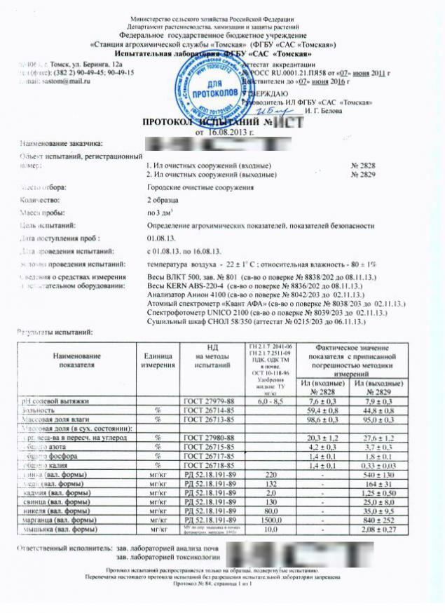
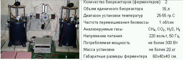
This baseline information needed for the experiments for the fermentation of biomass in biogas plants laboratory, in order to clarify the limiting calorie raw materials for biogas yield. Type and specifications laboratory facilities are presented in the photo.
The results of laboratory testing, information analysis of questionnaires and all the collected information be aggregated by experts in the final expert report which was the basis for making the information in the GIS. Taking into account only the large enterprises of agriculture, particularly with livestock not less than 500 head.
Around the same manner used by other groups of experts in the analysis of potential wind load, the solar insolation, the capacity of peat, geothermal, etc. Definitely use other instruments and laboratory installation in accordance with the objectives of the expert groups.


Analysis and Prospects of GIS h4> have been compiled and updated large amounts of information. GIS yielded a single information resource for the analysis of the potential of renewable raw materials for alternative energy sources. Given the development of renewable energy technologies will enable it to generate medium term projects to build generation facilities on alternative fuels. Thus now essential is the capacity of peat and wood processing waste production. Currently, work is underway on the analysis of promising technologies to solve these problems. Approaches to assessing the potential of renewable energy and competence of Tomsk expert groups can be used for similar work in other regions of Russia, and we are ready to share its experience in this area.
Link to GIS here . Reaction to the Habr-effect estimate can not. Possible failures.
Thanks h6> This work led dozens of people from different organizations, universities and research institutes in Tomsk. The work took about half a year. I thank all my colleagues who have worked on this project. GIS was built for the benefit of the Tomsk region and currently maintained and developed by the Center energy efficiency and conservation of the Tomsk region. Head of the Center Alexander Dmitriev and his staff were actively involved in this work and I also express my gratitude.
important addition i> h6> Many are extremely skeptical about the prospects for the use of biogas technology in Siberian conditions. This is indeed an interesting topic for analysis and discussion. In the coming days I will publish the corresponding post and I invite everyone to discuss this topic in more detail.
I>
Source: habrahabr.ru/post/229919/
Tags
See also
The beginning of the end: fossil fuels lost the race to renewable energy
The success of renewable energy in the world and attempts of development in Russia
The accumulation of energy in the air HES
Renewable energy sources and adverse environmental effects
Prospects for investment: by 2030 the share of green energy in the world will make 40%
Generation based on renewable energy will reduce harmful emissions
New Zealand instead of coal will switch to renewable energy
Effective use of renewable energy sources
American farmers and renewable energy