Russian attractions
 Bashny.Net
Interesting photo-excursion to the sights of our country, which are known not all residents of Russia. We watch and read further.
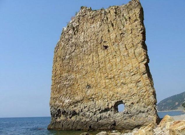
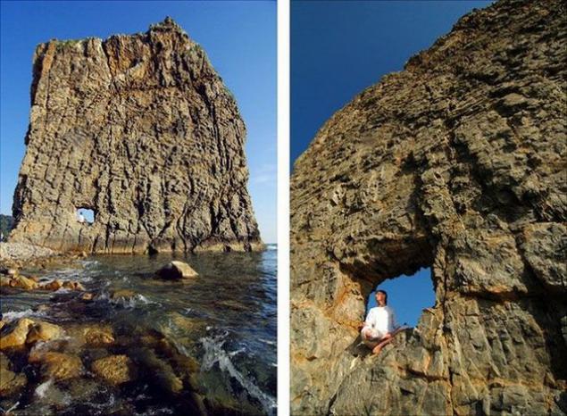
Sail Rock
Not far from the beach resort village in the Krasnodar Territory Praskoveevka is an interesting monument, the founder of which is the nature itself. It is a vertically standing on the seashore sandstone height of 30 m and a width of about 20 meters. How does it happen that this rock stands in splendid isolation on the coast, it is unclear: whether it broke away from the coastal cliffs and stayed in the sand, whether and it was at the same location. Among geologists, the second version of the popular. They say that the Sail - the only thing that remains after washing out the softer rocks sand sea. That is, when a sail was part of the sea bottom and the surface of the water was much higher.
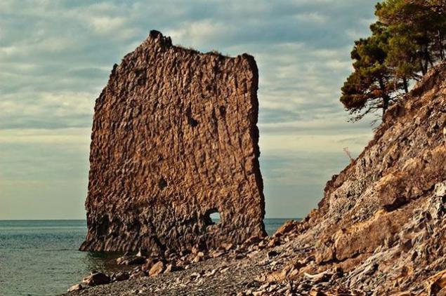
At an altitude of about 2, 5 meters Sail has a hole, the origin of which is unclear, too. Many guidebooks said that it punched arrows mountain artillery during the Caucasian War. However, this version of the origin of the holes being questioned: S. Vasiukov, who investigated the Black Sea coast, he wrote in 1903 after the examination of rock, that it "... fired from the battleship sailors let the projectile 4, but the wall remains unshaken, even though traces of nuclei nowhere broken through the cliff ... ».
Divnogorie
Divnogorie - reserve and plateaus in Liski district of Voronezh region, at the confluence of Quiet Pine and Don. Edge fabulous chalk mountains, cave churches and picturesque nature. From a geological point of view, reserve a cretaceous deposits on the surface of the earth. The top layer consists of 15-20% of chalk. Below 80 meters - a layer of pure chalk. The name of the area was Divnogorie Cretaceous poles, called the local population "divines" (from a miracle - a miracle).
The first written records are Smoljaninov Ignatius, accompanied by Metropolitan Pimen in 1389: "priplyhom to the quiet pines and stone pillars We have seen the white, red and wonderfully Well stand by, Thou stosis small, white, and exceedingly bright, above the river above the pines." Within the reserve are situated cave chalk church of the XVII century (Church Sicilian Icon of the Mother of God, Church of St. John the Baptist and Divnogorskiy-3), Mayak settlement IX-X centuries (the remains of a medieval fortress and necropolis) and Mayatsky pottery complex IX-X centuries, the Holy Dormition Divnogorskiy Monastery (XVII century).
Big Diva
Kostomarovskaya Saviour Nunnery - one of the oldest Russian monastery founded even before the official adoption of Christianity in Russia. There is an icon of the Valaam Mother of God.
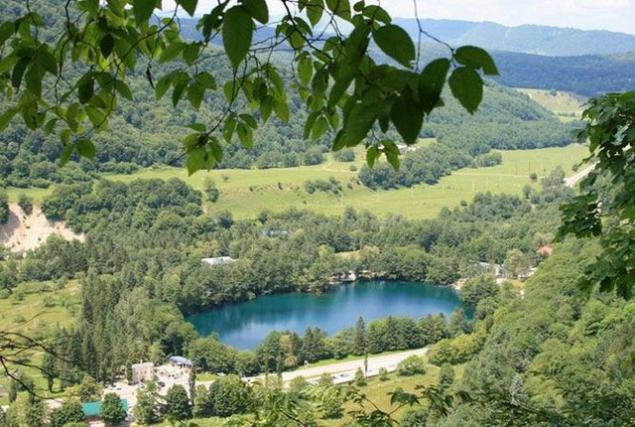
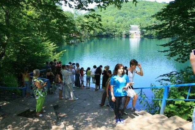
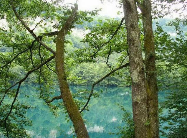
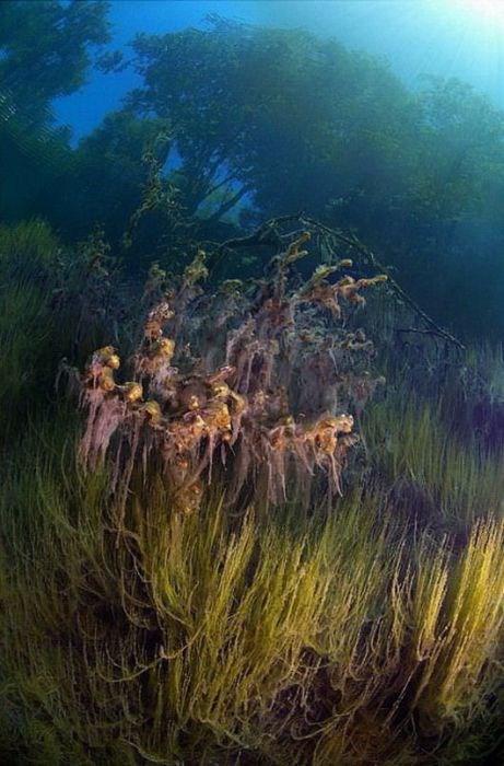
Blue Lake
The Cherek district of Kabardino-Balkaria are five unique natural lakes: Lower Blue, Secret, dry and two top blue. The most interesting is the lower lake, situated at the northern foot of the Rocky Mountain Range at an altitude of 1492 m. The unique is the fact that the small size (its area - 2, 6 hectares) it has a depth of 258 meters (according to other sources 368). This is the sixth deepest lake in the former USSR. The lake does not fall into a single stream and the river, as follows (in the river Cherek) daily about 70 million liters. Due to the presence of hydrogen sulphide water has a blue tint. Surface temperature in summer and winter is 9 and 3 ° C.
Mountain Vottovaara
Until now, an inquisitive researcher can find in remote corners of the taiga of Karelia monuments that do not fit in the logical representations of modern man. One of these monuments - a complex on Mount Vottovaara. Vottovaara Mountain (the highest point of the western Karelia - height 417 m) in Karelia superstitious people believe the Centre of the place of evil forces and a bridge to another world: there are growing ugly trees, almost no fauna, lakes dead. One name among the people that it is worth: Death Mountain.
In recent years, Death Mountain has become a place of pilgrimage for followers of different mystical directions, claiming that it is - a place of evil forces and the Centre of the bridge to the other world. Tops - a rocky plateau, some places are covered with trees of unusual shape and height. For example, the old, and the two hundred year old pine sto- is not higher than two meters. On top Vottovaara an area of approximately six square kilometers, is located approximately 1600 stones ("Karelian Stonehenge"), arranged in a mysterious manner. A number of large multi-ton stones placed on the "legs": a few smaller stones.
Some researchers suggest that it is an ancient religious complex. However, the official version prevails science of natural origin "Stonehenge". Geologists believe that the cracks and fissures formed by a powerful earthquake around 9000 years ago. Smooth stones same plane - the result of the properties of the local breed - quartzite, whose structure and defines a flat surface so the split.
"Stairway to Heaven»
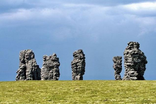
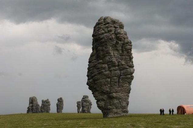
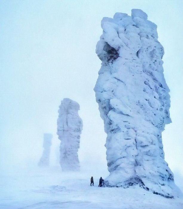
Pillars of weathering Man-Pupu-Nёr
Pillars of weathering on the plateau of Man-Pupu-Nёr in the Komi Republic (Mansi idiots). About 200 million years ago on the site of the stone pillars were high mountains. We passed the millennium. Rain, snow, wind, cold and heat gradually destroy the mountains, and especially weak rock. Solid seritsitokvartsitovye shales, which are composed of remnants were destroyed and fewer have survived, and soft rock had been destroyed by weathering and demolished by wind and water in the relief depressions. In the past, a place of religious worship Mansi people. Man-Pupu-Nёr Mansi language means "Little Mountain idols»
Shaitan Lake and the floating islands
One of the most unique lakes in Russia - Shaitan Lake, located 39 km from the city Urzhum. The lake is karst origin, the depth to 25 meters. Nourish underground lake of groundwater and precipitation. A unique phenomenon - drifting on the lake island, which grow bushes and small trees. Some of the islands bear the weight of several people. Another unique feature of the Shaitan-lake in emissions up fountains and water columns. The pillars are of different heights (up to 10m), emissions are irregular and rapid quick to see them - a great success. Locals claim that the emissions are in the winter, leaving the rearing sticking up thick ice floes.
In a clearing near the lake used to be a large two-storey wooden house, which belonged to the forest owner - the landowner and industrialist large Mosolov. Since his castle without permission cut down the forest, the forest ranger ordered Mosolov punish poachers not ruble, and a dip in the Shaitan. Guilty taken out on a boat and allowed to swim to shore. Tree cutting immediately stopped - the people terribly afraid of the lake.
Camel Mountain
Camel Mountain is located in the Orenburg region, 9 km south-east of the village on the left bank of East drying up the stream Ashchisu. It is a remnant of quartzite rock up to 20 meters. Camel is one of the most original natural sculptures and original symbol of Orenburg suhostepnogo Zauralye. For a long time the wind blew the soil, and the mountain, built of solid rock into a twenty-meter quartz boulder that resembles a camel lying.
On the rock many legends. One of them says that once the camel, coming from the desert, wanted to compete with the power of the Ural Mountains. I prepare for battle, and so it stood for centuries.
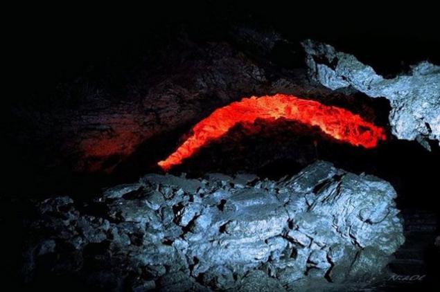
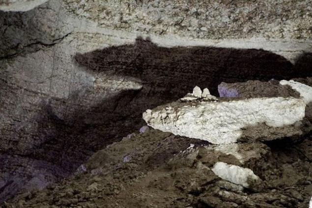
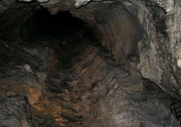
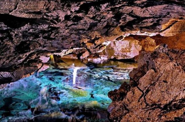
Kungur cave
Kungur Ice Cave - one of the largest karst caves in the world and one of the most popular attractions of the Urals. It is a cave in the Perm region, on the right bank of the river on the outskirts of Sylva Kungur Filippovka in the village (100 km from Perm). The length of the cave is about 5,700 meters, of which 1, 5 km equipped for visitors. The cave contains about 50 caves, 70 lakes, 146 so-called "organ pipes" (the highest - in the grotto of ether, 22 m) - the highest mine, reaching almost to the surface.
Coral Grotto
Hanging stone blocks in the grotto Dante
Grotto meteor
Stone rat in a grotto Custer
Pipe organ in the grotto of Friendship of Peoples
Underground lake
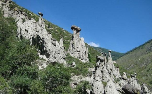
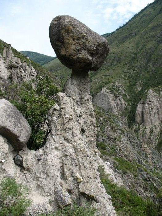
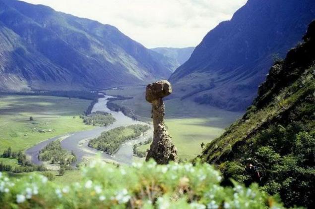
Stone mushrooms
Around 1, 5 km below the confluence of the river on the right bank Chulcha Chulyshman in the Altai Republic Akkurum tract begins, where the stone mushrooms - curious landforms formed by selective leaching (scientifically - denudation) inhomogeneous rocks. They look graceful and very unusual. One can only be glad that it is an unusual natural phenomenon survived to our time in all its glory. Unfortunately, these fungi continue to gradually disintegrate. It is said that during the earthquakes in Altai in 2003, several "hats" fall. Among geologists are of the opinion that our grandchildren they might no longer see.
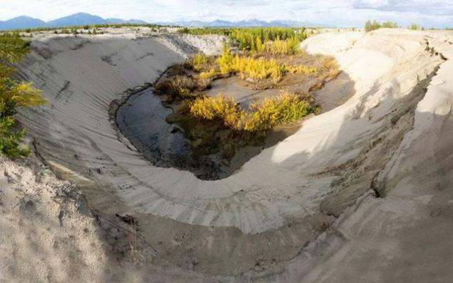
Chara Sands
Chara Sands - tract in Kalar district of the Chita Region, which is a sandy area of approximately 10 km by 5 km. It located in the Chara basin in the foothills Kodar, between the valleys of the rivers Chara, Middle and Upper Sakukan Sakukan. Surrounded by larch taiga and swamps. The length of the individual dunes 150-170 meters. Height of 80 m.
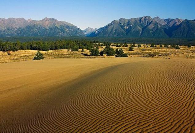
Desert sand dunes with an area of 100 square kilometers in the hundred-meter height of the towers in the swamps. No one really can not explain its origin. They say it is a grain of sand eroded from rocks and learned from Valley Middle Sakukana the plain. But why then the mountains are composed of sedimentary rocks and sand - pure quartz? Analogues of such a desert in the world there.
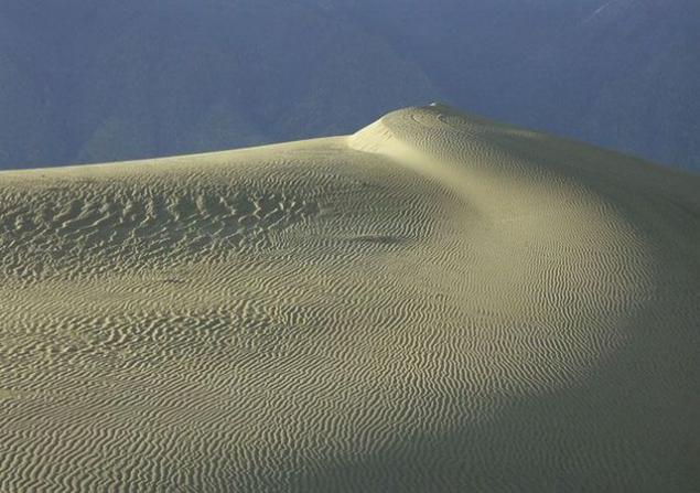
The desert begins a sharp transition from boron, larch or peat swamps to sand. None of the intermediate zone, no "terra nullius" - nature does not recognize the neutrality here. You can stand with one foot in the desert, and the other in the forest. In mezhbarhannyh depressions are forested areas - larch, ernika even hygrophilous cedar elfin. You can see this surreal landscape as ice in the sand (not necessarily in winter, but in summer).
Along the edges of the desert under the sands in many places streams flow. Water is clean.
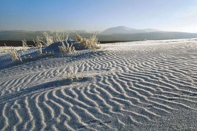
Chara Sands under snow
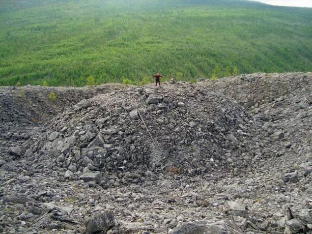
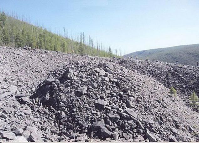
Patom crater
Patom crater in the Irkutsk region is a cone-shaped hill, consisting of crushed limestone, with a diameter of 180 m and a height of 40 m. At the top - whether meteorite crater, or volcanic origin. Among the local population is called "nest of fire eagle". Mysterious crater was discovered in 1951 by geologist Vladimir Kolpakov and still is one of the most mysterious objects in the natural world. By size and appearance it looks like a lunar crater.
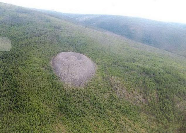
It is still unclear how it appeared on the surface of the earth. There is more than one dozen of his proishozheniya gepotez. Two key is: volcanic origin (but no traces of lava) and a trace of the fall of a huge meteorite on the ground (but not similar to a crater known to science meteorite craters). There are also more and fantastic version, for example, the result of an experiment Tesla or an alien spaceship crash site.
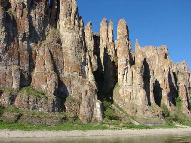
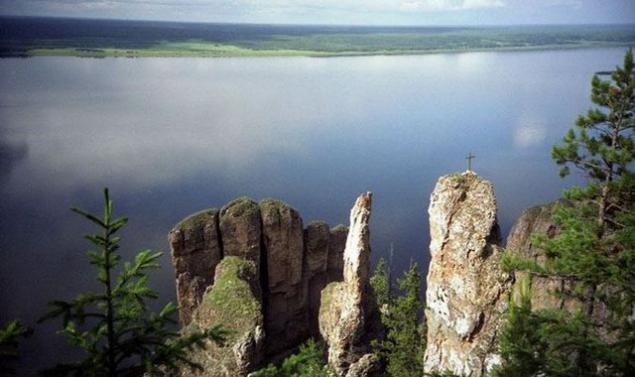
Lena Pillars
Lena Pillars - a geological formation and the eponymous national park in Russia, on the banks of the Lena River in Yakutia Khangalassky region, 104 km from the town of Pokrovsk. Lena Pillars are stretching for many kilometers vertically elongated rocks complex, intricately piled along the bank of the Lena, the deep valley cutting through Prilenskoye plateau. The highest density of poles reach between the villages of Peter and Tit-Ary. Rock formations whose height reaches 100 meters, composed of Cambrian limestone.
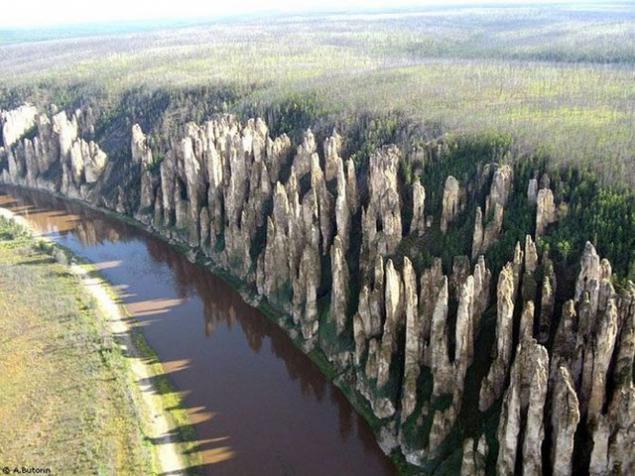
Start building rocks, laid down the monument of nature, usually dated to the early Cambrian - 560-540 million years ago. The formation of the Lena Pillars as a form of relief is dated much later period - about 400 thousand. Years ago, that is a relatively recent geological time.
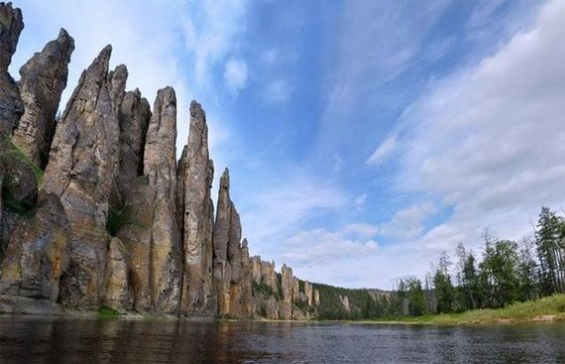
On the cliffs along the river banks of the Lena and the Blue discovered numerous rock petroglyphs, made of yellow mineral paint the ancient inhabitants of these places. It is preserved in varying degrees of stylized images of animals, fragments of inscriptions Old Turkic alphabet, rock composition with the image of man.
Decembrist AA Bestuzhev-Marly enthusiastically spoke of posts: "What a holy silence lies in the creation of a virgin, and the soul merges with dikoyu but majestic nature»
Cape Stolbchaty
Cape Stolbchaty Kunashir in the Kuril Islands (Sakhalin region) - a unique geological formation in the form of a continuous stone ridge, rising on the beach high vertical wall. Effusive volcanic rocks form a narrow 4, 5 and 6 carbon basalt columns, the so-called columnar separately. At the foot of the columnar wall lie in disarray, like a sawed firewood, ground bars.
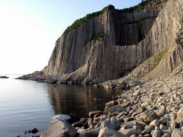
Lined sea waves coastal platform creates the illusion of the bridge, and keep from breaking the single poles similar to the remains of the broken fence. It is surprising that such an ideal composition creates a random nature, it is impossible to believe that the columnar structure formed flocked here a long time ago by lava flows.
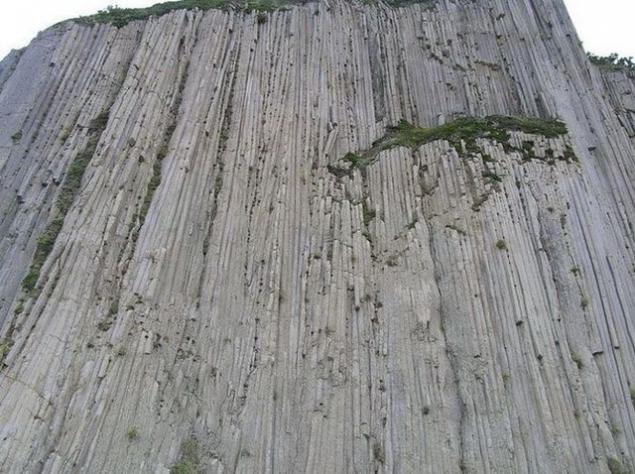
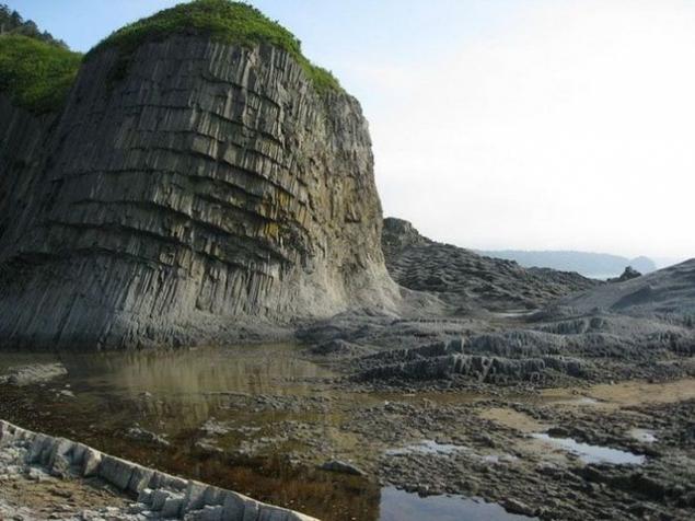
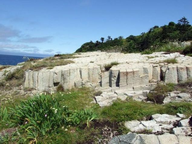
If you look at the "bridge" from the top, you will notice that the breed at the same time is divided not only on the individual columnar, but also for larger segments similar with smooth sides.
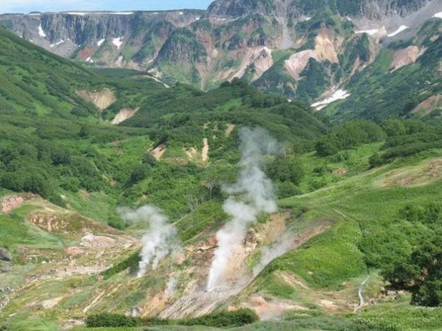
Valley of Geysers
Geyser Valley - one of the largest geyser field in the world and the only in Eurasia. Located on the Kamchatka Peninsula in the Kronotsky State Biosphere Reserve. At the confluence of Geyser and noisy on the territory of about 2 square kilometers is about 20 large geysers and many sources periodically emit fountains of almost boiling water (over 95C), or hot steam. Currently, part of the valley covered with a major landslide.
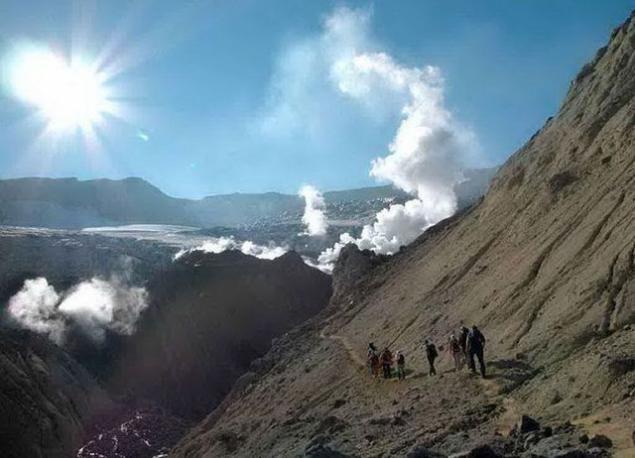
Valley was not discovered until the spring of 1941. The discovery made the young woman geologist Tatyana Ustinova with a guide-Itelmen Anisifor Krupenin. They went along the riverbed noisy and went into the narrow passage between the rocks and stopped far from the mouth of an unknown tributary. In April, still covered with snow. Something like sitting on a steep snow-covered slope, exhausted travelers decided to eat. On the opposite bank of the river could be seen thawed patch on which curled light steam. And suddenly - from straight towards them hit the jet of hot water! Tatyana Ustinova realized that before her real geyser - first discovered in the USSR.
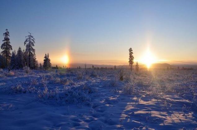
North Pole cold
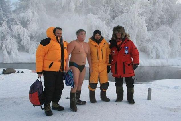
The North Pole is situated in the cold area Tomtor Oimyakon district (ulus) of Yakutia. Here, in 1924, it was recorded the lowest temperature in the northern hemisphere -71 2 ° C (-77 according to other sources, 8). The average monthly temperature in January is minus 61 degrees Celsius and the coldest days is minus 68. Throughout the world there are no more places at such low temperatures are constantly people live and work.
Temperatures below 60 degrees Celsius are here almost every January and in August can be a plus 30 and minus 15. In the village Tomtor annually tourist festival "Pole of Cold", which traditionally comes Santa Claus from Lapland. In March 2004, here opened residence of Santa Claus.
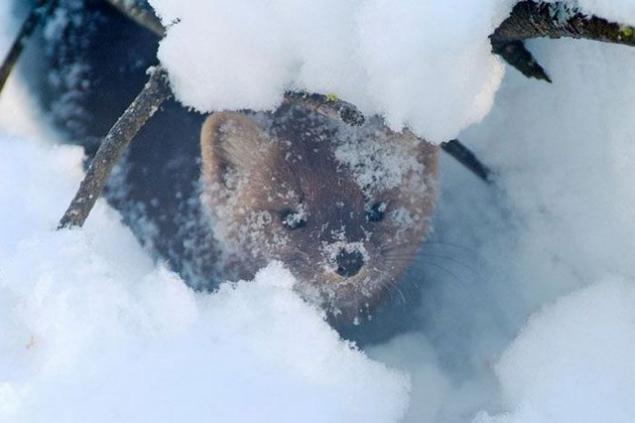
"Discovered" cold pole Sergei Vladimirovich Obruchev, a geologist, son of the author of the famous "Sannikov Land" and "Pluton" VA Obrucheva. Exploring the valley and toward the Indigirka Chersky hoops noticed a strange noise, which always accompanied him on the road. "Like pour grain or wind shakes the trees dry snow. Wherever you turn around - everywhere the noise, and yet there is no wind and the trees did not stir, "- he wrote later. Finally traveler guessed it rustles his frozen breath. This characteristic noise occurs when the cold below -50 ° C. Yakut call it a whisper of stars.
Local walrus Andrew bathed at -50. Fortunately, for this is not freezing due to the heat source stream.
Sail Rock
Not far from the beach resort village in the Krasnodar Territory Praskoveevka is an interesting monument, the founder of which is the nature itself. It is a vertically standing on the seashore sandstone height of 30 m and a width of about 20 meters. How does it happen that this rock stands in splendid isolation on the coast, it is unclear: whether it broke away from the coastal cliffs and stayed in the sand, whether and it was at the same location. Among geologists, the second version of the popular. They say that the Sail - the only thing that remains after washing out the softer rocks sand sea. That is, when a sail was part of the sea bottom and the surface of the water was much higher.

At an altitude of about 2, 5 meters Sail has a hole, the origin of which is unclear, too. Many guidebooks said that it punched arrows mountain artillery during the Caucasian War. However, this version of the origin of the holes being questioned: S. Vasiukov, who investigated the Black Sea coast, he wrote in 1903 after the examination of rock, that it "... fired from the battleship sailors let the projectile 4, but the wall remains unshaken, even though traces of nuclei nowhere broken through the cliff ... ».


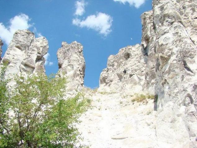
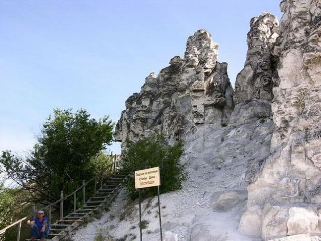
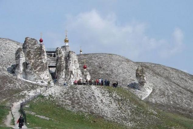
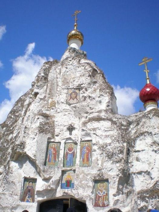
Divnogorie
Divnogorie - reserve and plateaus in Liski district of Voronezh region, at the confluence of Quiet Pine and Don. Edge fabulous chalk mountains, cave churches and picturesque nature. From a geological point of view, reserve a cretaceous deposits on the surface of the earth. The top layer consists of 15-20% of chalk. Below 80 meters - a layer of pure chalk. The name of the area was Divnogorie Cretaceous poles, called the local population "divines" (from a miracle - a miracle).

The first written records are Smoljaninov Ignatius, accompanied by Metropolitan Pimen in 1389: "priplyhom to the quiet pines and stone pillars We have seen the white, red and wonderfully Well stand by, Thou stosis small, white, and exceedingly bright, above the river above the pines." Within the reserve are situated cave chalk church of the XVII century (Church Sicilian Icon of the Mother of God, Church of St. John the Baptist and Divnogorskiy-3), Mayak settlement IX-X centuries (the remains of a medieval fortress and necropolis) and Mayatsky pottery complex IX-X centuries, the Holy Dormition Divnogorskiy Monastery (XVII century).
Big Diva

Kostomarovskaya Saviour Nunnery - one of the oldest Russian monastery founded even before the official adoption of Christianity in Russia. There is an icon of the Valaam Mother of God.


Blue Lake
The Cherek district of Kabardino-Balkaria are five unique natural lakes: Lower Blue, Secret, dry and two top blue. The most interesting is the lower lake, situated at the northern foot of the Rocky Mountain Range at an altitude of 1492 m. The unique is the fact that the small size (its area - 2, 6 hectares) it has a depth of 258 meters (according to other sources 368). This is the sixth deepest lake in the former USSR. The lake does not fall into a single stream and the river, as follows (in the river Cherek) daily about 70 million liters. Due to the presence of hydrogen sulphide water has a blue tint. Surface temperature in summer and winter is 9 and 3 ° C.


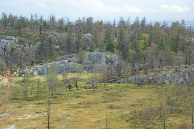
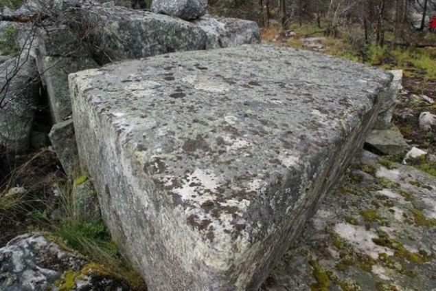
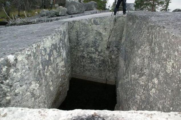
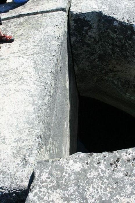
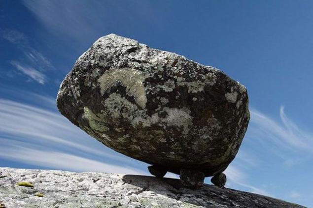
Mountain Vottovaara
Until now, an inquisitive researcher can find in remote corners of the taiga of Karelia monuments that do not fit in the logical representations of modern man. One of these monuments - a complex on Mount Vottovaara. Vottovaara Mountain (the highest point of the western Karelia - height 417 m) in Karelia superstitious people believe the Centre of the place of evil forces and a bridge to another world: there are growing ugly trees, almost no fauna, lakes dead. One name among the people that it is worth: Death Mountain.

In recent years, Death Mountain has become a place of pilgrimage for followers of different mystical directions, claiming that it is - a place of evil forces and the Centre of the bridge to the other world. Tops - a rocky plateau, some places are covered with trees of unusual shape and height. For example, the old, and the two hundred year old pine sto- is not higher than two meters. On top Vottovaara an area of approximately six square kilometers, is located approximately 1600 stones ("Karelian Stonehenge"), arranged in a mysterious manner. A number of large multi-ton stones placed on the "legs": a few smaller stones.

Some researchers suggest that it is an ancient religious complex. However, the official version prevails science of natural origin "Stonehenge". Geologists believe that the cracks and fissures formed by a powerful earthquake around 9000 years ago. Smooth stones same plane - the result of the properties of the local breed - quartzite, whose structure and defines a flat surface so the split.


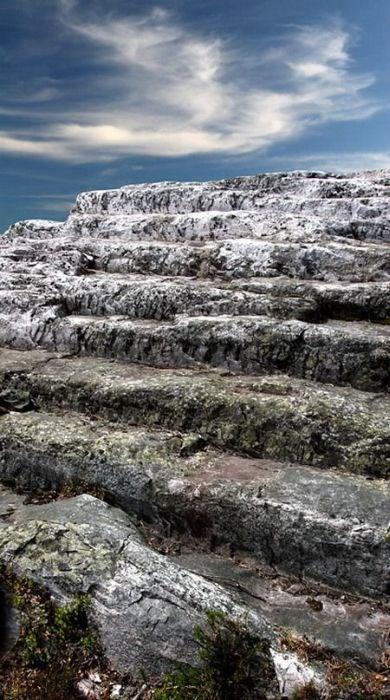
"Stairway to Heaven»

Pillars of weathering Man-Pupu-Nёr
Pillars of weathering on the plateau of Man-Pupu-Nёr in the Komi Republic (Mansi idiots). About 200 million years ago on the site of the stone pillars were high mountains. We passed the millennium. Rain, snow, wind, cold and heat gradually destroy the mountains, and especially weak rock. Solid seritsitokvartsitovye shales, which are composed of remnants were destroyed and fewer have survived, and soft rock had been destroyed by weathering and demolished by wind and water in the relief depressions. In the past, a place of religious worship Mansi people. Man-Pupu-Nёr Mansi language means "Little Mountain idols»


Shaitan Lake and the floating islands
One of the most unique lakes in Russia - Shaitan Lake, located 39 km from the city Urzhum. The lake is karst origin, the depth to 25 meters. Nourish underground lake of groundwater and precipitation. A unique phenomenon - drifting on the lake island, which grow bushes and small trees. Some of the islands bear the weight of several people. Another unique feature of the Shaitan-lake in emissions up fountains and water columns. The pillars are of different heights (up to 10m), emissions are irregular and rapid quick to see them - a great success. Locals claim that the emissions are in the winter, leaving the rearing sticking up thick ice floes.

In a clearing near the lake used to be a large two-storey wooden house, which belonged to the forest owner - the landowner and industrialist large Mosolov. Since his castle without permission cut down the forest, the forest ranger ordered Mosolov punish poachers not ruble, and a dip in the Shaitan. Guilty taken out on a boat and allowed to swim to shore. Tree cutting immediately stopped - the people terribly afraid of the lake.


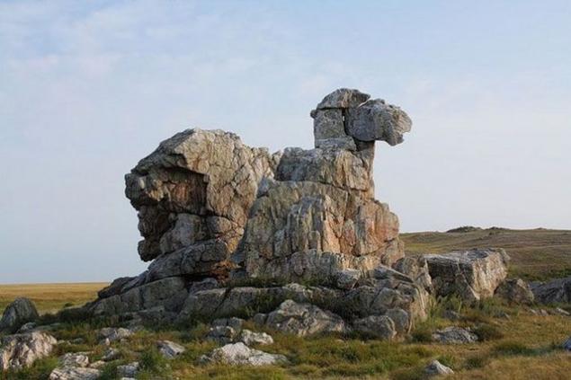
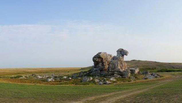
Camel Mountain
Camel Mountain is located in the Orenburg region, 9 km south-east of the village on the left bank of East drying up the stream Ashchisu. It is a remnant of quartzite rock up to 20 meters. Camel is one of the most original natural sculptures and original symbol of Orenburg suhostepnogo Zauralye. For a long time the wind blew the soil, and the mountain, built of solid rock into a twenty-meter quartz boulder that resembles a camel lying.

On the rock many legends. One of them says that once the camel, coming from the desert, wanted to compete with the power of the Ural Mountains. I prepare for battle, and so it stood for centuries.

Kungur cave
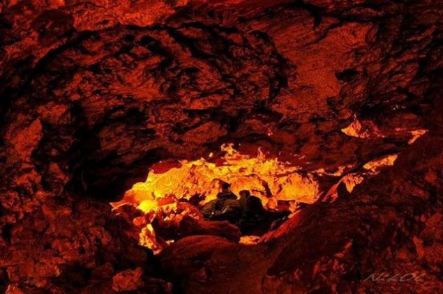
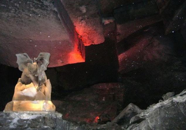
Kungur Ice Cave - one of the largest karst caves in the world and one of the most popular attractions of the Urals. It is a cave in the Perm region, on the right bank of the river on the outskirts of Sylva Kungur Filippovka in the village (100 km from Perm). The length of the cave is about 5,700 meters, of which 1, 5 km equipped for visitors. The cave contains about 50 caves, 70 lakes, 146 so-called "organ pipes" (the highest - in the grotto of ether, 22 m) - the highest mine, reaching almost to the surface.
Coral Grotto

Hanging stone blocks in the grotto Dante

Grotto meteor

Stone rat in a grotto Custer

Pipe organ in the grotto of Friendship of Peoples

Underground lake

Stone mushrooms
Around 1, 5 km below the confluence of the river on the right bank Chulcha Chulyshman in the Altai Republic Akkurum tract begins, where the stone mushrooms - curious landforms formed by selective leaching (scientifically - denudation) inhomogeneous rocks. They look graceful and very unusual. One can only be glad that it is an unusual natural phenomenon survived to our time in all its glory. Unfortunately, these fungi continue to gradually disintegrate. It is said that during the earthquakes in Altai in 2003, several "hats" fall. Among geologists are of the opinion that our grandchildren they might no longer see.


Chara Sands
Chara Sands - tract in Kalar district of the Chita Region, which is a sandy area of approximately 10 km by 5 km. It located in the Chara basin in the foothills Kodar, between the valleys of the rivers Chara, Middle and Upper Sakukan Sakukan. Surrounded by larch taiga and swamps. The length of the individual dunes 150-170 meters. Height of 80 m.

Desert sand dunes with an area of 100 square kilometers in the hundred-meter height of the towers in the swamps. No one really can not explain its origin. They say it is a grain of sand eroded from rocks and learned from Valley Middle Sakukana the plain. But why then the mountains are composed of sedimentary rocks and sand - pure quartz? Analogues of such a desert in the world there.

The desert begins a sharp transition from boron, larch or peat swamps to sand. None of the intermediate zone, no "terra nullius" - nature does not recognize the neutrality here. You can stand with one foot in the desert, and the other in the forest. In mezhbarhannyh depressions are forested areas - larch, ernika even hygrophilous cedar elfin. You can see this surreal landscape as ice in the sand (not necessarily in winter, but in summer).
Along the edges of the desert under the sands in many places streams flow. Water is clean.

Chara Sands under snow

Patom crater
Patom crater in the Irkutsk region is a cone-shaped hill, consisting of crushed limestone, with a diameter of 180 m and a height of 40 m. At the top - whether meteorite crater, or volcanic origin. Among the local population is called "nest of fire eagle". Mysterious crater was discovered in 1951 by geologist Vladimir Kolpakov and still is one of the most mysterious objects in the natural world. By size and appearance it looks like a lunar crater.

It is still unclear how it appeared on the surface of the earth. There is more than one dozen of his proishozheniya gepotez. Two key is: volcanic origin (but no traces of lava) and a trace of the fall of a huge meteorite on the ground (but not similar to a crater known to science meteorite craters). There are also more and fantastic version, for example, the result of an experiment Tesla or an alien spaceship crash site.


Lena Pillars
Lena Pillars - a geological formation and the eponymous national park in Russia, on the banks of the Lena River in Yakutia Khangalassky region, 104 km from the town of Pokrovsk. Lena Pillars are stretching for many kilometers vertically elongated rocks complex, intricately piled along the bank of the Lena, the deep valley cutting through Prilenskoye plateau. The highest density of poles reach between the villages of Peter and Tit-Ary. Rock formations whose height reaches 100 meters, composed of Cambrian limestone.

Start building rocks, laid down the monument of nature, usually dated to the early Cambrian - 560-540 million years ago. The formation of the Lena Pillars as a form of relief is dated much later period - about 400 thousand. Years ago, that is a relatively recent geological time.

On the cliffs along the river banks of the Lena and the Blue discovered numerous rock petroglyphs, made of yellow mineral paint the ancient inhabitants of these places. It is preserved in varying degrees of stylized images of animals, fragments of inscriptions Old Turkic alphabet, rock composition with the image of man.

Decembrist AA Bestuzhev-Marly enthusiastically spoke of posts: "What a holy silence lies in the creation of a virgin, and the soul merges with dikoyu but majestic nature»

Cape Stolbchaty
Cape Stolbchaty Kunashir in the Kuril Islands (Sakhalin region) - a unique geological formation in the form of a continuous stone ridge, rising on the beach high vertical wall. Effusive volcanic rocks form a narrow 4, 5 and 6 carbon basalt columns, the so-called columnar separately. At the foot of the columnar wall lie in disarray, like a sawed firewood, ground bars.

Lined sea waves coastal platform creates the illusion of the bridge, and keep from breaking the single poles similar to the remains of the broken fence. It is surprising that such an ideal composition creates a random nature, it is impossible to believe that the columnar structure formed flocked here a long time ago by lava flows.


If you look at the "bridge" from the top, you will notice that the breed at the same time is divided not only on the individual columnar, but also for larger segments similar with smooth sides.

Valley of Geysers
Geyser Valley - one of the largest geyser field in the world and the only in Eurasia. Located on the Kamchatka Peninsula in the Kronotsky State Biosphere Reserve. At the confluence of Geyser and noisy on the territory of about 2 square kilometers is about 20 large geysers and many sources periodically emit fountains of almost boiling water (over 95C), or hot steam. Currently, part of the valley covered with a major landslide.

Valley was not discovered until the spring of 1941. The discovery made the young woman geologist Tatyana Ustinova with a guide-Itelmen Anisifor Krupenin. They went along the riverbed noisy and went into the narrow passage between the rocks and stopped far from the mouth of an unknown tributary. In April, still covered with snow. Something like sitting on a steep snow-covered slope, exhausted travelers decided to eat. On the opposite bank of the river could be seen thawed patch on which curled light steam. And suddenly - from straight towards them hit the jet of hot water! Tatyana Ustinova realized that before her real geyser - first discovered in the USSR.


North Pole cold
The North Pole is situated in the cold area Tomtor Oimyakon district (ulus) of Yakutia. Here, in 1924, it was recorded the lowest temperature in the northern hemisphere -71 2 ° C (-77 according to other sources, 8). The average monthly temperature in January is minus 61 degrees Celsius and the coldest days is minus 68. Throughout the world there are no more places at such low temperatures are constantly people live and work.

Temperatures below 60 degrees Celsius are here almost every January and in August can be a plus 30 and minus 15. In the village Tomtor annually tourist festival "Pole of Cold", which traditionally comes Santa Claus from Lapland. In March 2004, here opened residence of Santa Claus.

"Discovered" cold pole Sergei Vladimirovich Obruchev, a geologist, son of the author of the famous "Sannikov Land" and "Pluton" VA Obrucheva. Exploring the valley and toward the Indigirka Chersky hoops noticed a strange noise, which always accompanied him on the road. "Like pour grain or wind shakes the trees dry snow. Wherever you turn around - everywhere the noise, and yet there is no wind and the trees did not stir, "- he wrote later. Finally traveler guessed it rustles his frozen breath. This characteristic noise occurs when the cold below -50 ° C. Yakut call it a whisper of stars.

Local walrus Andrew bathed at -50. Fortunately, for this is not freezing due to the heat source stream.

Tags
See also
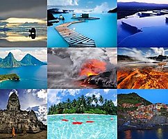
The most beautiful places of the world (22 photos)
"This doctrine can be applied in the country, you do not mind ..."
Natural wonder of Ukraine: Podilski Tovtry
5 countries that are willing to will give you long-term "Schengen"
Here are 5 countries that will be happy to issue you a Schengen for many years
200 facts about New York City through the eyes of Russians
On urgent measures in connection with the military aggression of the Russian Federation
10 mysterious corners of Russia, of which only a few know. It would have gone there!
These countries, which will ruin the climate
Malievtsy