Curiosity sets off a year-long
 Bashny.Net
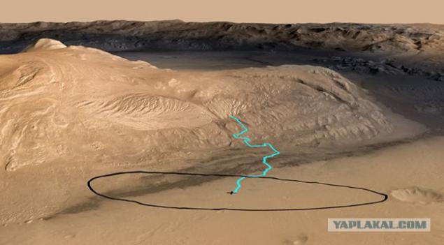
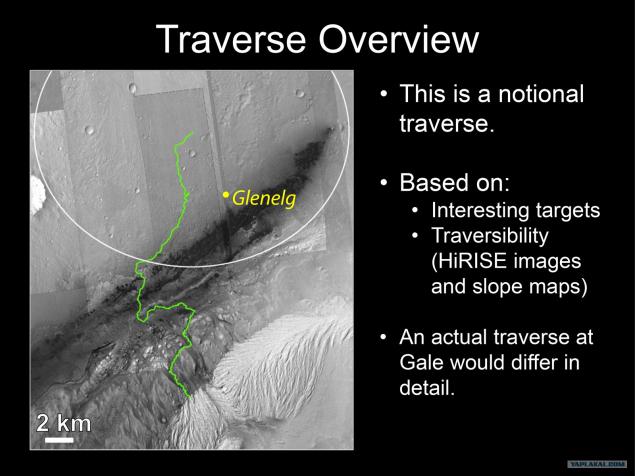
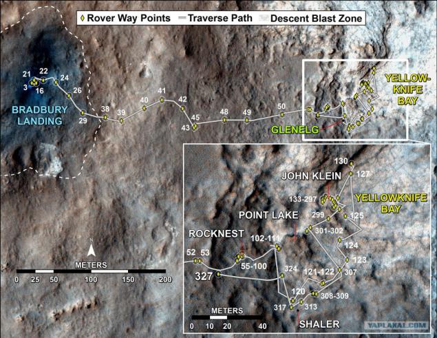
Engineers and geologists NASA, finally played enough with his favorite child. To shoot laser nasverlili wells found clay. 11 months after planting, they remembered that they had a research plan, and it is time to begin to implement it already. To do this, Curiosity got to get to Mount Sharp (Eolidy). But do not go anywhere - in a straight line until it is now about 3 km away, and to a certain place, which had been pre-planned satellite - into the canyon, which is washed in the mountainside.
17 photos + text.
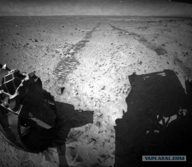
But before you make a step towards the dream, Curiosity completed all business in Glenelg about this story today.
I recall, the rover landing went just beyond the center of the alleged landing ellipse and deviated from the route, which he outlined the creators before sending to Mars. Despite this, the accuracy of his "primarseniya" surpasses all previous experience NASA. When scientists looked closer to the place where landed Curiosity, then pay attention to one part of the landscape. Approximately 400 meters to the northeast, at one point came together three types of surface observed in the crater Gale. One of them - the removal of soil, which brought the flow of water from the edge of the crater. Rover just sat on it.
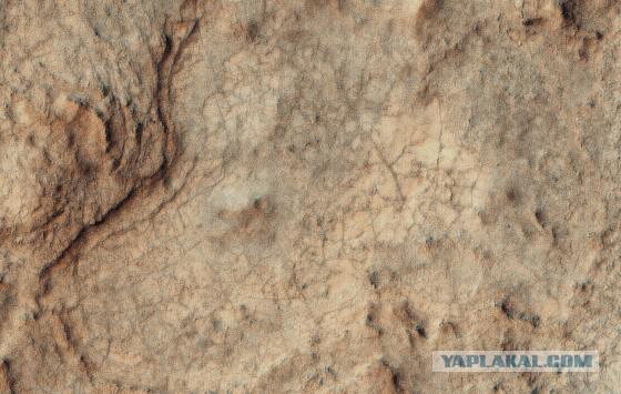
The second type of surface, seen from orbit by Mars Odyssey infrared camera distinguished by high thermal inertia, that is, it is heated for a long time and a long time to cool, than very different from neighboring areas. Outwardly, he looked like the bottom of a dried puddle - a sleek and cracked.
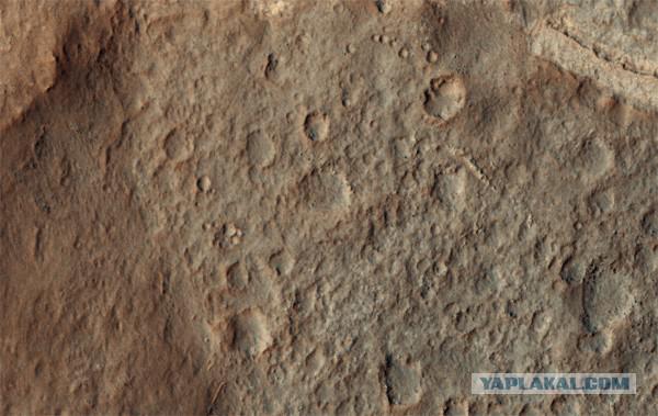
The third type of surface has attracted the attention of high-frequency location of small craters. It pointed to the fact that it is the ancient site that has survived millions of years of meteorite bombardment.
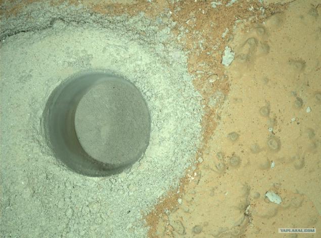
Scientists decided to unplanned travel to Glenelg. From the first steps of the way Curiosity studied under the surface "with their feet" and almost immediately found pebbles rounded by water. Once he got to Glenelg, scientists are faced with such geological diversity, which is not even dreamed of. Research from the satellite did not assume such an abundance of layers and types of rocks. Curiosity led the study after study that surprised geologists, and became the apotheosis of all searches extracted from the second well Cumberland almost wet clay.
Posted in [mergetime] 1373918517 [/ mergetime]
Curiosity drilling operations started at the bottom of depressions, called Yellowknifle Bay - one that looked like a dried puddle. No wonder that she turned it - the bottom of the lake. The water content of the clay was so high that the rover was delayed for a few days in the hope of finding the morning frost, which would condense the water evaporates over the hole. Found or not - it is not known. Official reports have not yet been.
LeAnn tried to determine spectrometer ChemCam
Meanwhile, the meeting of geologists scientific mission is getting hotter. Scientists have argued over the future activities of the rovers. Some, blinded by an abundance of Glenelg, offered to stay and continue to work for several months. Others - called for a return to the early route. The latter include and John Grotzinger - the supervisor of the program. As a result, the second well was the final at this stage.
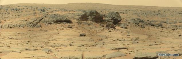
But before you go on a long journey, scientists have persuaded the chief to stay another couple of months and see two objects, which have long looked closely, but not enough time to get to them. First in line was the site Point Lake. It is a dark cliff that looms over Yellowknifle Bay. He looked after in the fall by the provisional target for drill testing, but then found a more interesting object and drove past.
Posted in [mergetime] 1373918648 [/ mergetime]
At this time, the rover to act without delay. Choose a convenient place for lifting, crossed the "threshold" that separated the conventional "reservoir" from the "shore" and moved to the Point Lake
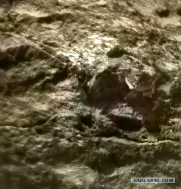
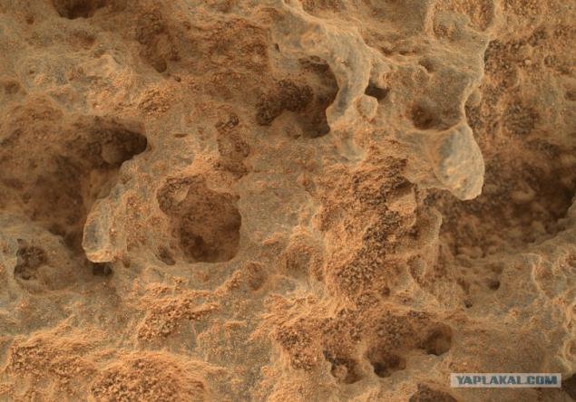
Along the way, his attention was drawn to the curious "bubbles" that occurred in that place before. Geologically, these formations belong to the same layer as the Point Lake, so the cause of them is the same.
But what is not yet known. NASA adheres to two basic hypotheses: volcanic or sedimentary rock. It is emphasized that none of them is preferred. Although I think it's still signs of activity of the volcano. I already wrote that the eye on the right near the mountain, which will suit the role of the candidate of the volcano, so if NASA confirms this hypothesis I will be pleased.
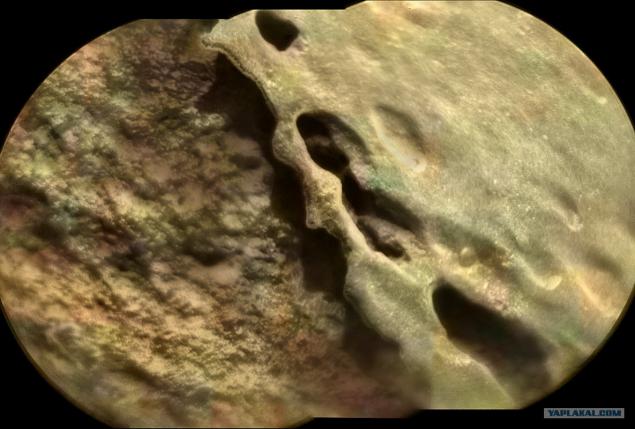
Point Lake wanted to explore using makrokamery MAHLI. But the original block to which the sizing, consider not work - at its foot was too rough surface, engineers feared that the situation is too unstable, and when deploying the rover arm can sway uncontrollably. So pay attention to closer and more accessible stone.
On the way he looked through a telescope ChemCam:
And, approaching closely, the same portions removed and MAHLI.
Preliminary examination showed that the bubble surface of the stone varies. Inside there is a breed of bubbles of different composition, and it better resists erosion. Moreover, in the distance, there are interesting stones that are still waiting to be discovered dinosaur egg shell of a captive audience REN-TV.
Such shells turned round when the "bubble" collapsed from erosion and rock fill it remained lying on the sand.
After MAHLI and ChemCam, Curiosity spectrometer APXS only kissed and moved on.
The next target was another interesting slope which was named after the American paleontologist Shaler and inspected at the beginning of winter. Then the bottom Yellowknifle Bay beckoned stronger, so the rover only one panorama shot and went down. Now it's time to go back and look better.
Shaler - quite a long section where the slope of the rock acts like our earth flagstone. But we have it often is limestone, ie formed with the participation of living organisms. Hoping to Mars is no longer necessary, so NASA geologists are considering two options for education, too: under the influence of wind or water. Another preliminary inspection showed that this sandstone - ie ordinary sand grains which are connected a cementitious breed.
Geologists had to find an answer to the question of what caused the displacement of sand in such layers. Once the water was preferred hypothesis, because grains were too large to be collected by the wind. The layers may also vary depending on changes in water regime, and one WSS place - from climate change. Separate intriguing point is that Shaler - a land of the most ancient area of Glenelg affected by meteorites.
Inspection and ChemCam MAHLI allowed to consider all the details.
Contrary to the initial impression, the layers Shaler does not uniform. There's a layer of coarse sand:
There are other, highly susceptible to erosion:
There, on the contrary unusually smooth, but also pitted time:
Of course, NASA, using data from the spectrometers, and attracting experienced geologists, get more information about this area than our superficial glance. Let's wait for the next conference, to take a look publications on this topic.
In parting, Curiosity took a last look at the foot of Mount Sharp.
Full size here gigapan.com/gigapans/134189
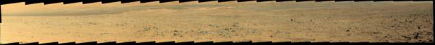
Anything left of the center, we will never see in more detail than it is now.
Curiosity finally returned to the tracks, which are paved in October 2012, but then deviated from them and moved in its annual eight-kilometer flight.
We can only continue to follow this most exciting trophy-raid in the solar system.
I have everything.
via Habr
Source:
17 photos + text.

But before you make a step towards the dream, Curiosity completed all business in Glenelg about this story today.
I recall, the rover landing went just beyond the center of the alleged landing ellipse and deviated from the route, which he outlined the creators before sending to Mars. Despite this, the accuracy of his "primarseniya" surpasses all previous experience NASA. When scientists looked closer to the place where landed Curiosity, then pay attention to one part of the landscape. Approximately 400 meters to the northeast, at one point came together three types of surface observed in the crater Gale. One of them - the removal of soil, which brought the flow of water from the edge of the crater. Rover just sat on it.
The second type of surface, seen from orbit by Mars Odyssey infrared camera distinguished by high thermal inertia, that is, it is heated for a long time and a long time to cool, than very different from neighboring areas. Outwardly, he looked like the bottom of a dried puddle - a sleek and cracked.

The third type of surface has attracted the attention of high-frequency location of small craters. It pointed to the fact that it is the ancient site that has survived millions of years of meteorite bombardment.

Scientists decided to unplanned travel to Glenelg. From the first steps of the way Curiosity studied under the surface "with their feet" and almost immediately found pebbles rounded by water. Once he got to Glenelg, scientists are faced with such geological diversity, which is not even dreamed of. Research from the satellite did not assume such an abundance of layers and types of rocks. Curiosity led the study after study that surprised geologists, and became the apotheosis of all searches extracted from the second well Cumberland almost wet clay.
Posted in [mergetime] 1373918517 [/ mergetime]
Curiosity drilling operations started at the bottom of depressions, called Yellowknifle Bay - one that looked like a dried puddle. No wonder that she turned it - the bottom of the lake. The water content of the clay was so high that the rover was delayed for a few days in the hope of finding the morning frost, which would condense the water evaporates over the hole. Found or not - it is not known. Official reports have not yet been.
LeAnn tried to determine spectrometer ChemCam

Meanwhile, the meeting of geologists scientific mission is getting hotter. Scientists have argued over the future activities of the rovers. Some, blinded by an abundance of Glenelg, offered to stay and continue to work for several months. Others - called for a return to the early route. The latter include and John Grotzinger - the supervisor of the program. As a result, the second well was the final at this stage.

But before you go on a long journey, scientists have persuaded the chief to stay another couple of months and see two objects, which have long looked closely, but not enough time to get to them. First in line was the site Point Lake. It is a dark cliff that looms over Yellowknifle Bay. He looked after in the fall by the provisional target for drill testing, but then found a more interesting object and drove past.
Posted in [mergetime] 1373918648 [/ mergetime]
At this time, the rover to act without delay. Choose a convenient place for lifting, crossed the "threshold" that separated the conventional "reservoir" from the "shore" and moved to the Point Lake

Along the way, his attention was drawn to the curious "bubbles" that occurred in that place before. Geologically, these formations belong to the same layer as the Point Lake, so the cause of them is the same.
But what is not yet known. NASA adheres to two basic hypotheses: volcanic or sedimentary rock. It is emphasized that none of them is preferred. Although I think it's still signs of activity of the volcano. I already wrote that the eye on the right near the mountain, which will suit the role of the candidate of the volcano, so if NASA confirms this hypothesis I will be pleased.
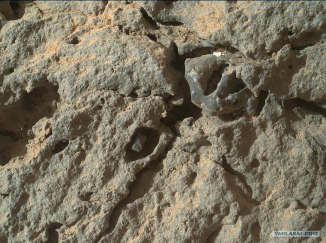
Point Lake wanted to explore using makrokamery MAHLI. But the original block to which the sizing, consider not work - at its foot was too rough surface, engineers feared that the situation is too unstable, and when deploying the rover arm can sway uncontrollably. So pay attention to closer and more accessible stone.
On the way he looked through a telescope ChemCam:

And, approaching closely, the same portions removed and MAHLI.

Preliminary examination showed that the bubble surface of the stone varies. Inside there is a breed of bubbles of different composition, and it better resists erosion. Moreover, in the distance, there are interesting stones that are still waiting to be discovered dinosaur egg shell of a captive audience REN-TV.

Such shells turned round when the "bubble" collapsed from erosion and rock fill it remained lying on the sand.
After MAHLI and ChemCam, Curiosity spectrometer APXS only kissed and moved on.
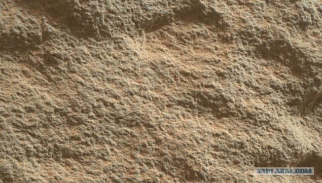
The next target was another interesting slope which was named after the American paleontologist Shaler and inspected at the beginning of winter. Then the bottom Yellowknifle Bay beckoned stronger, so the rover only one panorama shot and went down. Now it's time to go back and look better.

Shaler - quite a long section where the slope of the rock acts like our earth flagstone. But we have it often is limestone, ie formed with the participation of living organisms. Hoping to Mars is no longer necessary, so NASA geologists are considering two options for education, too: under the influence of wind or water. Another preliminary inspection showed that this sandstone - ie ordinary sand grains which are connected a cementitious breed.
Geologists had to find an answer to the question of what caused the displacement of sand in such layers. Once the water was preferred hypothesis, because grains were too large to be collected by the wind. The layers may also vary depending on changes in water regime, and one WSS place - from climate change. Separate intriguing point is that Shaler - a land of the most ancient area of Glenelg affected by meteorites.
Inspection and ChemCam MAHLI allowed to consider all the details.
Contrary to the initial impression, the layers Shaler does not uniform. There's a layer of coarse sand:

There are other, highly susceptible to erosion:

There, on the contrary unusually smooth, but also pitted time:

Of course, NASA, using data from the spectrometers, and attracting experienced geologists, get more information about this area than our superficial glance. Let's wait for the next conference, to take a look publications on this topic.
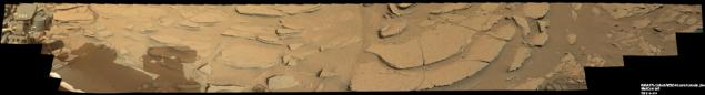
In parting, Curiosity took a last look at the foot of Mount Sharp.
Full size here gigapan.com/gigapans/134189

Anything left of the center, we will never see in more detail than it is now.
Curiosity finally returned to the tracks, which are paved in October 2012, but then deviated from them and moved in its annual eight-kilometer flight.

We can only continue to follow this most exciting trophy-raid in the solar system.
I have everything.
via Habr

Source:
Tags
See also
Russian diamonds
Mars rover Curiosity has completed basic scientific mission
Top 10 of best countries to travel this summer. Pakuy bags and hit the road!
Steve Palin: Do not place easily achievable goals!
Hiroshima and Nagasaki: 65 years of tragedy
5 dirty tricks used by Apple,
5 dirty tricks Apple uses to get you to buy a new iPhone