Beautiful pictures hazard - hurricane.
 Bashny.Net
Beautiful pictures hazard - hurricane. But in space, it is, fortunately, is perfectly safe.
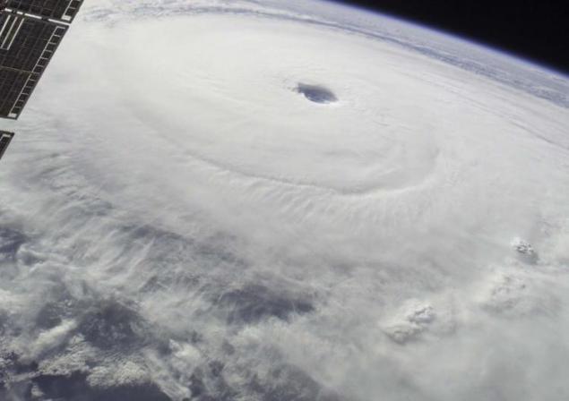
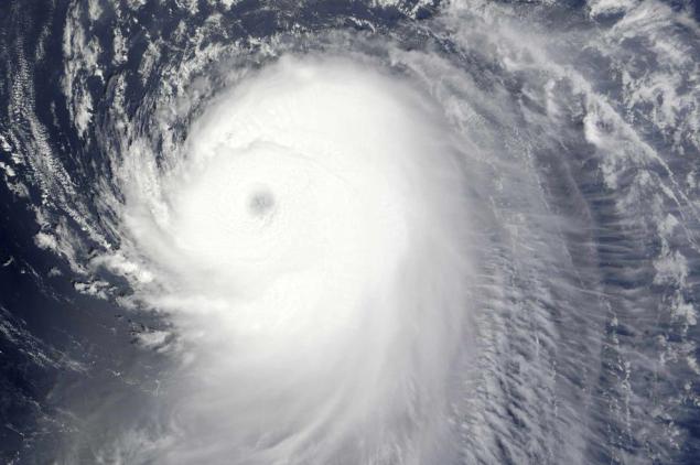
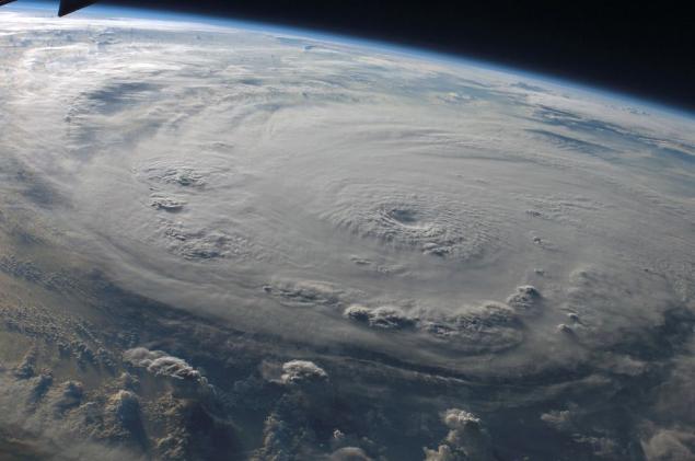
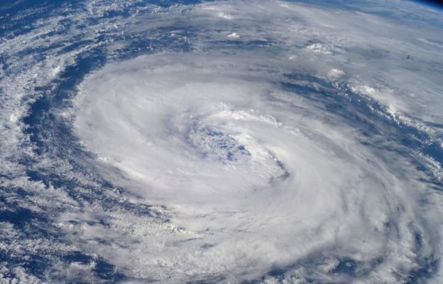
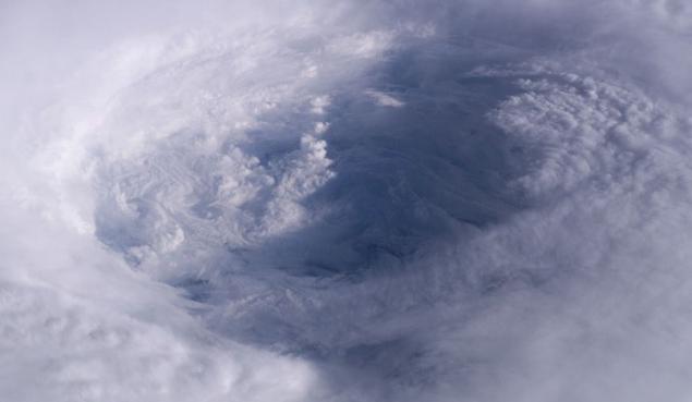
1. On the morning of September 4, at the time when this photograph was taken from the window of the International Space Station from a height of 220 miles, Hurricane Ike strengthened to the fourth category. Ike appeared in the northwest Atlantic Ocean, thanks to the wind in the 120 nautical miles, sometimes with gusts up to 145 miles. (Photo courtesy NASA and the crew of the International Space Station)
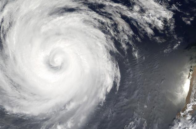
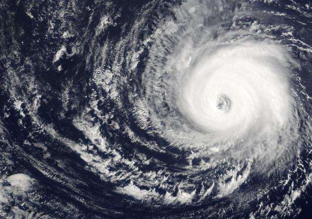
2. This picture taken by satellite Terra, remembering Hurricane Ike, who left the shores of the Lesser Antilles, and headed to the coast of the Bahamas, Thursday, September 4, 2008, 10:40 am. "Ike looks very dangerous," - said FEMA Administrator David Polison. (NASA / AP Photo)
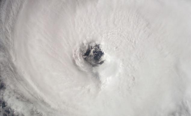
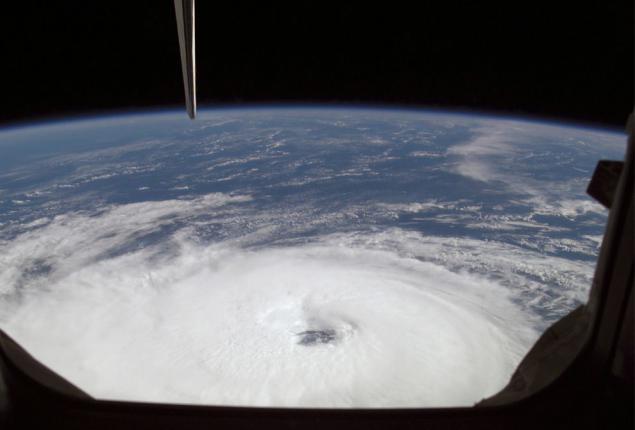
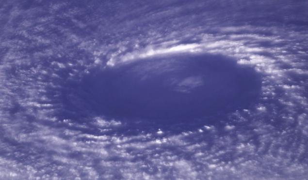
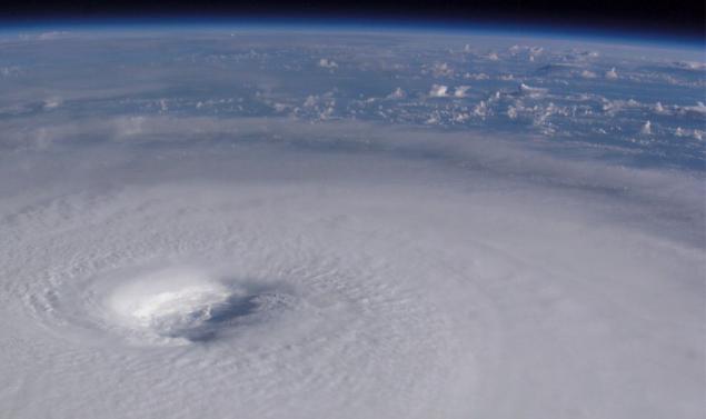
3. In this photograph taken from the spacecraft "Atlantis" September 18, 2006, clearly shows the eye of Hurricane Gordon. At the time when this photo was taken with a camera lens in 28 mm., The center of the hurricane was located at coordinates 37.5 ° north latitude and 46 ° east longitude 4 and moving in a northwesterly direction. Maintained hurricane winds of 80 nautical miles per hour with gusts up to 95 miles per hour. (NASA)
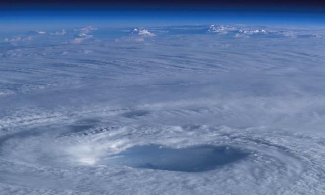
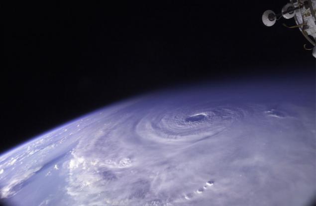
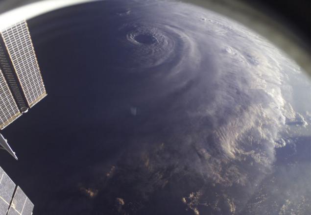
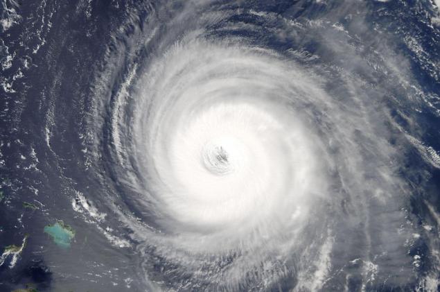
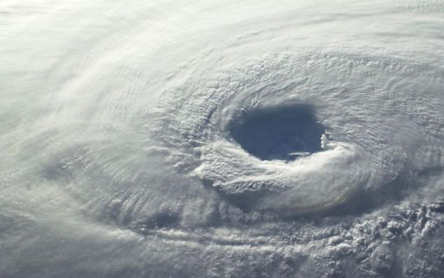
4. At the center of this picture you can see the eye of Hurricane Ivan and part of the solar panels of the International Space Station. The strongest hurricane Ivan was captured from a height of 230 miles an astronaut Edward Michael Fink - flight engineer team working at the time on the ISS. At the time of the shooting, Ivan was on the west of the Caribbean Sea, the wind speed was 160 miles per hour. (NASA)
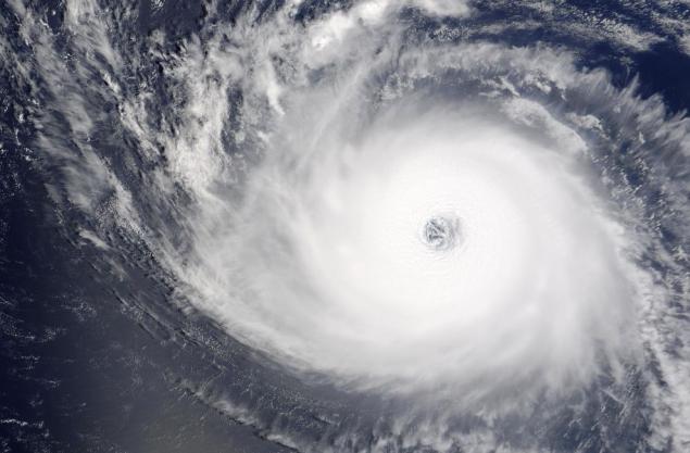
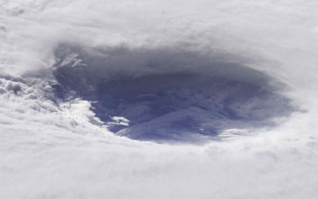
5. September 12, 2003 renders Moderate Resolution Spectroradiometer (MODIS), located on board the Terra satellite, remembering Hurricane Isabel off the coast of the Lesser Antilles. At that time, Isabel reached the highest category five power, wind speed is 160 miles per hour. (Jacques Descloitres, MODIS Rapid Response Team, NASA / GSFC)
6. This picture of Hurricane Felix was made on 3 September 2007 at 11:38:29 GMT. One of the members of the 15th expedition to the ISS took this picture using the camera with 28-70 mm. lens. At the time of the shooting ISS was over the eastern coast of Honduras. Because of squalls speed of 165 miles per hour with gusts Felix was awarded fifth category on a scale Saffir-Simpson Hurricane. (NASA)
7. Photo taken on board the Space Shuttle "Atlantis" September 18, 2006, allows a good view of Hurricane Gordon. At the time of the shooting eye of the hurricane was located at coordinates 37, 5 ° north latitude and 46.4 ° East longitude and moving in a northwesterly direction. Wind speed was 80 nautical miles per hour with gusts up to 95 miles per hour. (NASA)
8. Photo of Hurricane Katrina was made a member of the eighth expedition to the ISS March 27, 2004. Hurricane was shot on the way to the shores of the southern Brazilian state of Katrina (which is why he was given the name "Katrina"). Vortex cloud around the nucleus of the typhoon, cyclone circulation of the Southern Hemisphere, is at least to the first category. (NASA)
9. In this photograph taken by astronaut Edward Michael Fink day on Wednesday 15 September 2004, Hurricane Ivan was captured on the way to the northern part of the Gulf Coast. The wind speed at the epicenter was 135 miles per hour. This picture was taken from a height of 230 miles. (NASA)
10. This image of Hurricane Wilma made at 8:23 am, on Wednesday, October 19, 2005 members of the ISS crew, at a time when the station was at an altitude of 222 miles from the epicenter. Then Wilma became one of the most powerful storms, the wind speed reached 175 miles per hour. Wilma swept over the waters of the Caribbean Sea 340 miles from Cozumel, Mexico. (NASA)
11. In this photo captures Hurricane Ivan in the Gulf Coast, which is due to a severe storm hit the coast of Alabama, on September 15, 2004. The wind speed was 135 miles per hour. (NASA)
12. Photo Hurricane Epsilon in the Atlantic Ocean was made a member of the crew of the 12th expedition to the ISS 3 December 2005. The space station was located at an altitude of 190 miles. The epicenter of the hurricane was located at coordinates 34, 5 ° north latitude and 44.4 ° east longitude. (NASA)
13. Strongest Hurricane Ivan was captured from a height of 230 miles an astronaut Edward Michael Fink - flight engineer team working at the time on the ISS on September 11, 2004. (NASA)
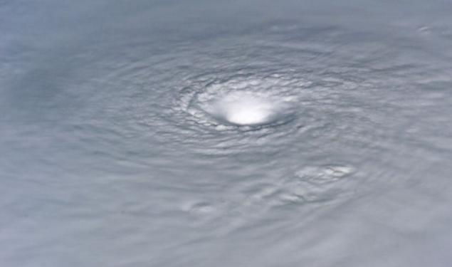
14. This close-up of the eye of Hurricane Isabel was shot September 15, 2003 one of the crew members of the 7th expedition to the ISS. (NASA)
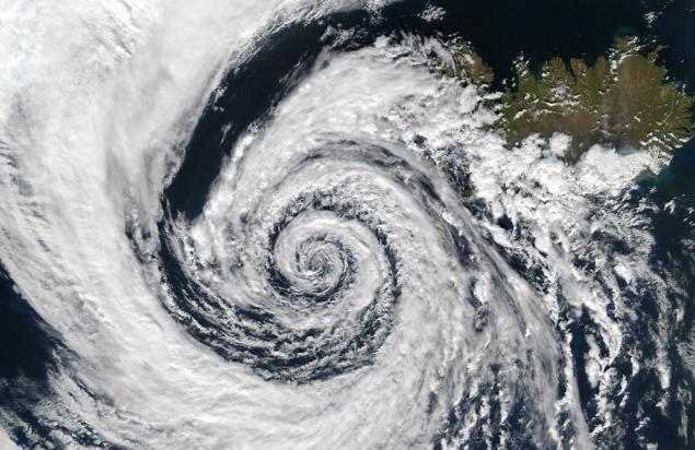
15. In the picture of 4 September 2003 there is a hurricane, but you can see a low pressure area, which constitutes a swirl of clouds in the south-east Greenland. This phenomenon illustrates the saying "nature abhors a vacuum." An empty space in this case resulted from the low atmospheric pressure. Rushed to fill the void of air layers with high atmospheric pressure, taking the clouds. This is a huge phenomenon circled over the Denmark Strait between Greenland and Iceland. (Jacques Descloitres, MODIS Rapid Response Team, NASA / GSFC)
16. This close-up of the eye of Hurricane Isabel was shot by a member of the crew of the seventh expedition to the ISS. At the time of the shooting, September 13, 2003, Isabel reached Category 5, the wind speed was 160 miles per hour. (NASA)
17. Hurricane Douglas, July 23, 2002. Power Douglas dropped to the first category, as he was removed from the peninsula of Baja California, deep Pacific Ocean. This picture was taken visualizing medium resolution spectroradiometer (MODIS), mounted on the Terra satellite on July 23. (Jacques Descloitres, MODIS Land Rapid Response Team, NASA / GSFC)
18. Strongest Hurricane Ivan was captured from a height of 230 miles an astronaut Edward Michael Fink - flight engineer team working at the time on the ISS on September 11, 2004. At the time of the shooting Ivan raged in the west of the Caribbean Sea, the wind speed reached 160 miles per hour. (NASA)
19. Close-up of the eye of Hurricane Ivan. The picture was taken from the International Space Station on Sept. 11, 2004. (NASA)
20. Visualize the Moderate Resolution Spectroradiometer (MODIS), mounted on the satellite Aqua, remembering Hurricane Isabel September 14, 2003, 17:55. The hurricane was about 400 miles from Puerto Rico, the wind speed was 155 miles per hour. (Jacques Descloitres, MODIS Rapid Response Team, NASA / GSFC)
21. Close-up of the eye of Hurricane Isabel. The picture was taken from the International Space Station on Sept. 15, 2003. (NASA)
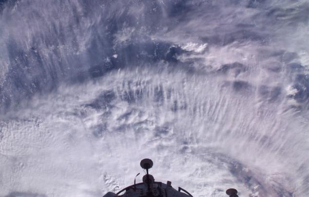
22. On the International Space Station are clearly visible ring of clouds at the time, the station passes over Hurricane Frances on September 2, 2004. (NASA)
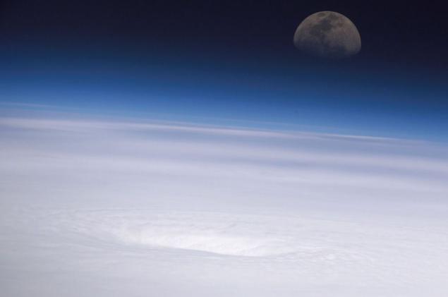
1. On the morning of September 4, at the time when this photograph was taken from the window of the International Space Station from a height of 220 miles, Hurricane Ike strengthened to the fourth category. Ike appeared in the northwest Atlantic Ocean, thanks to the wind in the 120 nautical miles, sometimes with gusts up to 145 miles. (Photo courtesy NASA and the crew of the International Space Station)

2. This picture taken by satellite Terra, remembering Hurricane Ike, who left the shores of the Lesser Antilles, and headed to the coast of the Bahamas, Thursday, September 4, 2008, 10:40 am. "Ike looks very dangerous," - said FEMA Administrator David Polison. (NASA / AP Photo)

3. In this photograph taken from the spacecraft "Atlantis" September 18, 2006, clearly shows the eye of Hurricane Gordon. At the time when this photo was taken with a camera lens in 28 mm., The center of the hurricane was located at coordinates 37.5 ° north latitude and 46 ° east longitude 4 and moving in a northwesterly direction. Maintained hurricane winds of 80 nautical miles per hour with gusts up to 95 miles per hour. (NASA)

4. At the center of this picture you can see the eye of Hurricane Ivan and part of the solar panels of the International Space Station. The strongest hurricane Ivan was captured from a height of 230 miles an astronaut Edward Michael Fink - flight engineer team working at the time on the ISS. At the time of the shooting, Ivan was on the west of the Caribbean Sea, the wind speed was 160 miles per hour. (NASA)

5. September 12, 2003 renders Moderate Resolution Spectroradiometer (MODIS), located on board the Terra satellite, remembering Hurricane Isabel off the coast of the Lesser Antilles. At that time, Isabel reached the highest category five power, wind speed is 160 miles per hour. (Jacques Descloitres, MODIS Rapid Response Team, NASA / GSFC)

6. This picture of Hurricane Felix was made on 3 September 2007 at 11:38:29 GMT. One of the members of the 15th expedition to the ISS took this picture using the camera with 28-70 mm. lens. At the time of the shooting ISS was over the eastern coast of Honduras. Because of squalls speed of 165 miles per hour with gusts Felix was awarded fifth category on a scale Saffir-Simpson Hurricane. (NASA)

7. Photo taken on board the Space Shuttle "Atlantis" September 18, 2006, allows a good view of Hurricane Gordon. At the time of the shooting eye of the hurricane was located at coordinates 37, 5 ° north latitude and 46.4 ° East longitude and moving in a northwesterly direction. Wind speed was 80 nautical miles per hour with gusts up to 95 miles per hour. (NASA)

8. Photo of Hurricane Katrina was made a member of the eighth expedition to the ISS March 27, 2004. Hurricane was shot on the way to the shores of the southern Brazilian state of Katrina (which is why he was given the name "Katrina"). Vortex cloud around the nucleus of the typhoon, cyclone circulation of the Southern Hemisphere, is at least to the first category. (NASA)

9. In this photograph taken by astronaut Edward Michael Fink day on Wednesday 15 September 2004, Hurricane Ivan was captured on the way to the northern part of the Gulf Coast. The wind speed at the epicenter was 135 miles per hour. This picture was taken from a height of 230 miles. (NASA)

10. This image of Hurricane Wilma made at 8:23 am, on Wednesday, October 19, 2005 members of the ISS crew, at a time when the station was at an altitude of 222 miles from the epicenter. Then Wilma became one of the most powerful storms, the wind speed reached 175 miles per hour. Wilma swept over the waters of the Caribbean Sea 340 miles from Cozumel, Mexico. (NASA)

11. In this photo captures Hurricane Ivan in the Gulf Coast, which is due to a severe storm hit the coast of Alabama, on September 15, 2004. The wind speed was 135 miles per hour. (NASA)

12. Photo Hurricane Epsilon in the Atlantic Ocean was made a member of the crew of the 12th expedition to the ISS 3 December 2005. The space station was located at an altitude of 190 miles. The epicenter of the hurricane was located at coordinates 34, 5 ° north latitude and 44.4 ° east longitude. (NASA)

13. Strongest Hurricane Ivan was captured from a height of 230 miles an astronaut Edward Michael Fink - flight engineer team working at the time on the ISS on September 11, 2004. (NASA)

14. This close-up of the eye of Hurricane Isabel was shot September 15, 2003 one of the crew members of the 7th expedition to the ISS. (NASA)

15. In the picture of 4 September 2003 there is a hurricane, but you can see a low pressure area, which constitutes a swirl of clouds in the south-east Greenland. This phenomenon illustrates the saying "nature abhors a vacuum." An empty space in this case resulted from the low atmospheric pressure. Rushed to fill the void of air layers with high atmospheric pressure, taking the clouds. This is a huge phenomenon circled over the Denmark Strait between Greenland and Iceland. (Jacques Descloitres, MODIS Rapid Response Team, NASA / GSFC)

16. This close-up of the eye of Hurricane Isabel was shot by a member of the crew of the seventh expedition to the ISS. At the time of the shooting, September 13, 2003, Isabel reached Category 5, the wind speed was 160 miles per hour. (NASA)

17. Hurricane Douglas, July 23, 2002. Power Douglas dropped to the first category, as he was removed from the peninsula of Baja California, deep Pacific Ocean. This picture was taken visualizing medium resolution spectroradiometer (MODIS), mounted on the Terra satellite on July 23. (Jacques Descloitres, MODIS Land Rapid Response Team, NASA / GSFC)

18. Strongest Hurricane Ivan was captured from a height of 230 miles an astronaut Edward Michael Fink - flight engineer team working at the time on the ISS on September 11, 2004. At the time of the shooting Ivan raged in the west of the Caribbean Sea, the wind speed reached 160 miles per hour. (NASA)

19. Close-up of the eye of Hurricane Ivan. The picture was taken from the International Space Station on Sept. 11, 2004. (NASA)

20. Visualize the Moderate Resolution Spectroradiometer (MODIS), mounted on the satellite Aqua, remembering Hurricane Isabel September 14, 2003, 17:55. The hurricane was about 400 miles from Puerto Rico, the wind speed was 155 miles per hour. (Jacques Descloitres, MODIS Rapid Response Team, NASA / GSFC)

21. Close-up of the eye of Hurricane Isabel. The picture was taken from the International Space Station on Sept. 15, 2003. (NASA)

22. On the International Space Station are clearly visible ring of clouds at the time, the station passes over Hurricane Frances on September 2, 2004. (NASA)

Tags
See also
A look at the Earth from a height of 350 km
3D-printer for the first time published in the product space
Beautiful pictures of Earth from space (11 photos)
Hit shots 2012. Part 4.
Pictures from space
Photos Sun Alan Friedman
Beautiful Planet
Incredible photo of astronaut Douglas Wheelock space
Photos of ghosts