View from the water - the only way to really see (21 photos)
 Bashny.Net
One blogger visited the stunning location and made some great shots. That's what tells ...

While the speed of travel continues to grow, good to know that there is (and always will) the places that can be reached only by water. I grew up in Georgia, and I was always amazed how easy it is to be in the boat, looking at the river bank or walk over the bridge (as opposed to sitting in the car on the bridge in a traffic jam), this gives you a completely different view of the world. It is in this spirit that I have collected the following photos of the places on the water, you have to see. Most of them are cut off in the sense that you can not get access to them in any way, except for the boat.
Rio Pacuare, Costa Rica
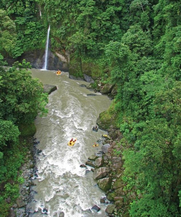
I rafted the Pacuare in early 2000, when it was under threat of flooding due to construction of the proposed hydroelectric plant. In subsequent years, the river, though, was safe from flooding, but no one knows when there will be new proposals. Since river canyons illustrate the concept of "out of sight, out of mind", they are particularly vulnerable to environmental legislation / energy policy, which can only rely on small public protest. Only those few indigenous people who live near and rely on a clean, unobstructed river for survival, and / or those who work in the tourism industry and helps to develop new local economy in the region, in fact, never even see these places and care them. With warm water and a large, cheerful, but not particularly difficult rapids, Pacuare River is a classic for rafting, and the only way to get access to some almost impassable areas of the cloud forest.
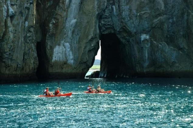
Marine Reserve Whanganui-A-Hei Marine Reserve, North Island, New Zealand
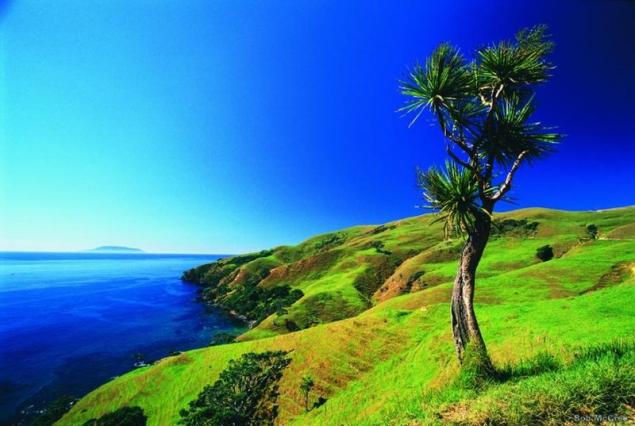
Marine Reserve Te Whanganui-A-Hei (also known as the Catherdral Cove) is named after the large sea cave that connects the bay to bay Leg Cathedral. The reserve also includes bays Gemstone and Stingray. Despite the fact that there are hiking trails on the northern end of Hahei Beach, Hahei between the top and the Gulf of Gemstone, the only way to really explore the area - take a sea kayak.
Average tributary Salmon, Idaho

Average tributary Salmon is one of the classic routes for boating in the US and crosses the region's largest off-road. Its length is more than 160 miles, and is usually divided into the journey 5 days; it passes through the deep canyons with more than 100 rapids, 60 of which belong to the class III and IV and took place in the early days. Particularly notable are the numerous natural hot springs along the river banks.
Charles Darwin Station, Santa Cruz, Galapagos Islands
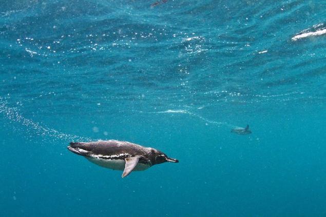
Magellanic penguins in the Galapagos Islands. The largest city of Santa Cruz is located in the archipelago, Puerto Ayora, and here are the same research station of Charles Darwin and the headquarters of the National Park Service of the Galapagos Islands.
National Park and Preserve Kluan, Yukon
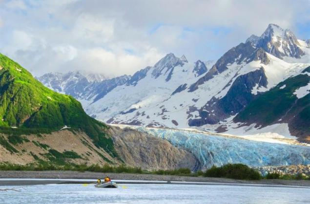
The largest protected area in the world is located in the Yukon, where converge National Park and Preserve Kuan and Wildlife Park Tatshenshini River, Alsek Bay Glesher and National Park Wrangell-Saint Elias. Bypass this area is carried out by a multi-day trips by boat down the river Alsek. Travel passes through massive canyons, dense forests and clusters of icebergs.
Baja, Mexico
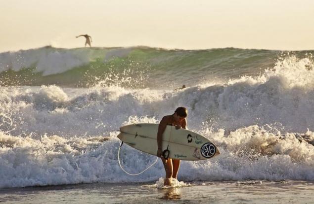
Despite the fact that to most of Baja can be reached by car (an important exception is the Sea of Cortez and several Pacific islands such as Todos Santos), there is probably another of the peninsula, the journey to which the water will be as comfortable as possible. When you surf on a deserted beach, and the point on the yellowtail fishing, diving in Los Cabos, enjoy sailing or just swimming with a mask and flippers, watching the lobster hastily flee in niches along the sandy bottom beach, you realize that you can not really "grasp" Bach without water.
Glacier Torresillas, Chubut, Argentina

Although the land approach to the glacier Torresillas theoretically possible, as many formations of the Andes, in fact it is only available for rowing boats on lakes and rivers. To get to Torresillas, you have to cross Lago Verde in Puerto Mermud, then go to Puerto Chuka. Reaching Puerto Chuck, you have to navigate through the eastern branch of Lake Menendez.
Panama Canal
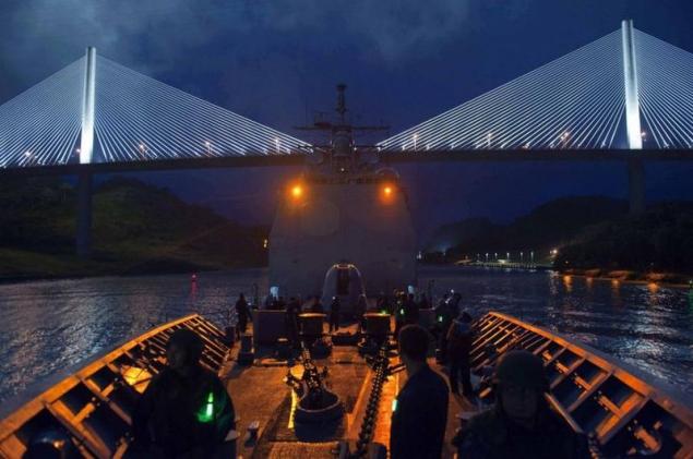
00 years later the Panama Canal remains one of the special feats in the world of technology. While the passage of his very popular, an incredible variety of wildlife and culture, bordering the waterway is less well-known, especially in the jungles of Darien, where the Embera indigenous people, whose traditional way of life has remained unchanged for 600 years. There are numerous access points for rafting and scuba diving on the beaches of the Pearl Islands, as well as wildlife watching Gatun Lake and the River Chagres.
Lake Taupo Maori, New Zealand
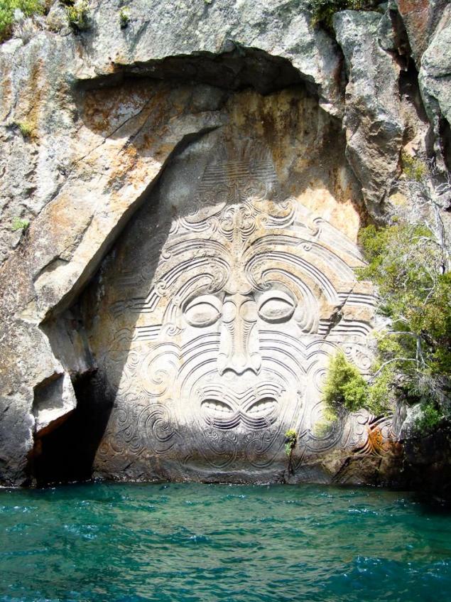
Lake Taupo is the largest lake in New Zealand and a place for various adventures, including the annual cycling race on 193-kilometer perimeter of the lake. On the northwest side of the lake, along the cliffs of the Gulf Main, has rock carvings Maori access to which is possible only by boat.
Bosphorus, Istanbul
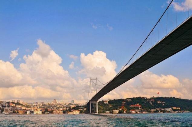
View from the water is always different: the Bosphorus, the narrow strait the most in the world used for international navigation, is the channel that separates Europe from Asia, and reaches less than 3,000 meters at its narrowest point. Ferries and cruise ships pass by the ornate palaces of the Ottoman Empire, such Rustem Pasha complex of the 16th century. Istanbul is situated on both sides of the strait.
The island of San Cristobal, Galapagos Islands
San Cristobal - a place in the Galapagos Islands, but once you find yourself there, you will need to get wet to really see everything. The combination of a boat trip, snorkeling and lying on the beach is the best in Cerro Brouilly, which is home to the blue-footed boobies, brown pelicans, marine iguanas, Sally Lightfoot crabs, sea turtles, sea lions, and sunlight - to Kicker Rock.
Darien Gap, Panama
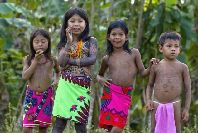
Embera indigenous children, whose mother is the province of Darien. Bordering the province in the east region of Colombia, known as the Darien Gap is the only off-road strip Pan-American Highway (interconnected system of roads from Alaska to the tip of South America). Despite the fact that Darien can be achieved in several ways land, the vast majority of travelers use the ferries around the dense swamps and jungle. Embera people also use the river system as a transport artery, building villages along the coast throughout the watershed Chukunak / Tuira / Balsas, Maranhão.
Victoria Island, Nahuel Huapi, Patagonia

Perhaps the most significant element of northern Patagonia is almost unreal transparency of its lakes and rivers. Nahuel Huapi, which surrounds Bariloche, Argentina, is the largest and deepest lake with clean water in the area of Lake. It has a natural reserve, Victoria Island, reachable by boat. One notable elements of Nahuel Huapi is a breeze. Several times I saw the winds are strong enough to make waves for surfing.
Svalbard, Norway

Spitsbergen is home to abundant wildlife, including polar bears, beluga whales, walrus, reindeer, arctic foxes, and the vast array of bird fauna. The only way to navigate passes through the area of the polar expedition ships, icebreakers.
Antarctica
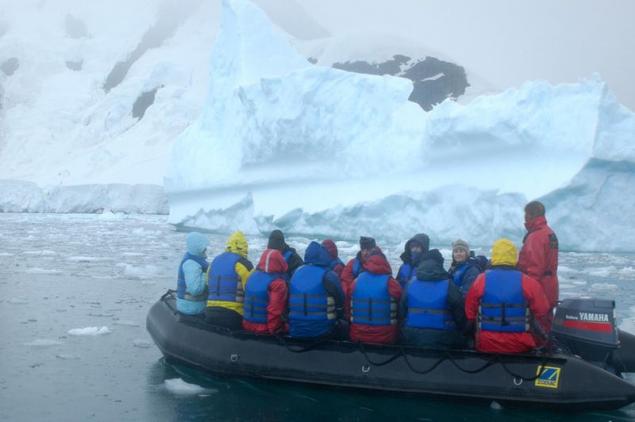
Court-breakers provide access to the fjords and tear off the ice of Antarctica, while the Zodiac (like this one) and kayaks allow us to consider a close-up wildlife during the Antarctic summer, the breeding season of penguins, seabirds, seals and whales.
Chichagof Island, Alaska
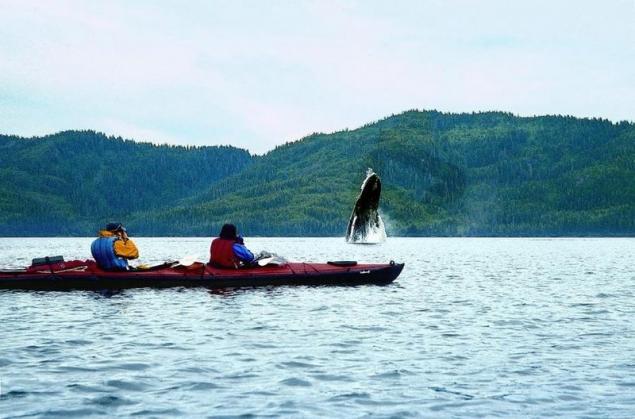
Chichagof Island is located in the Alexander Archipelago, Alaska on the spur of Alaska. The entire coastline (over 1120 km) and close to the land and its connecting paths - Baranof Island, Strait of danger, the Strait of Chatham Strait Strait, Cross Sound and the Gulf of Alaska - really available for exploration only by boat. This area is notable for its marine life, including humpback whales, sea lions, otters and seals.
The archipelago of Yasawa Fiji
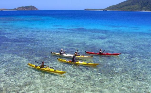
Part Fiji Yasawa Islands poorly developed for tourism, and until 2004 there was not yet any motorized vehicle for a trip to the largest island (Taveva), which means that a) the travelers in this part of the world are moving on a boat (better all sea kayak), and b) you can still see the true Polynesian culture.
Bay Alsek
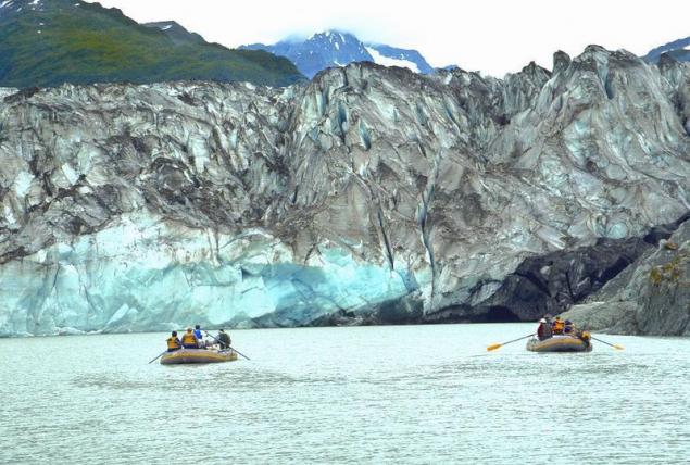
The river Tatshenshini River about 160 miles from Dalton Post in the Yukon Territory through the Alsek Bay, where huge chunks of ice break into the water from the 11-kilometer ice surface Alsek.
Amazon

After descending the river Napo, a large tributary of the Amazon, a boat crosses the lake Pilchikocha towards Sacha Lodge, a private ecological reserve area of 5,000 acres.
Tortuguero National Park, Costa Rica

Along with the Caribbean coast of Costa Rica (Limón), Tortuguero National Park can be studied only by boat. Tortuguero is home to 11 different habitats that include jungle, palm forests, mangroves, marshes, beaches and lagoons, and has an incredibly varied wildlife.
The Arctic National Wildlife Refuge, Alaska
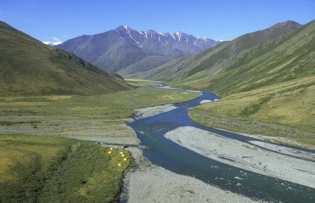
If you can not fly in a small plane, the only real way to see the Arctic National Wildlife Refuge is navigating the river Kongakut on the Brooks Range. In the end, reaching the Arctic coastal plain, the river passes through some of the wildest valleys in the world, where hundreds of square kilometers of pristine habitat provided grizzly Dalla sheep, wolves, deer and porcupines. In the summer, this area is almost constantly lit by daylight.
Source: www.expedia.mx

While the speed of travel continues to grow, good to know that there is (and always will) the places that can be reached only by water. I grew up in Georgia, and I was always amazed how easy it is to be in the boat, looking at the river bank or walk over the bridge (as opposed to sitting in the car on the bridge in a traffic jam), this gives you a completely different view of the world. It is in this spirit that I have collected the following photos of the places on the water, you have to see. Most of them are cut off in the sense that you can not get access to them in any way, except for the boat.
Rio Pacuare, Costa Rica

I rafted the Pacuare in early 2000, when it was under threat of flooding due to construction of the proposed hydroelectric plant. In subsequent years, the river, though, was safe from flooding, but no one knows when there will be new proposals. Since river canyons illustrate the concept of "out of sight, out of mind", they are particularly vulnerable to environmental legislation / energy policy, which can only rely on small public protest. Only those few indigenous people who live near and rely on a clean, unobstructed river for survival, and / or those who work in the tourism industry and helps to develop new local economy in the region, in fact, never even see these places and care them. With warm water and a large, cheerful, but not particularly difficult rapids, Pacuare River is a classic for rafting, and the only way to get access to some almost impassable areas of the cloud forest.
Marine Reserve Whanganui-A-Hei Marine Reserve, North Island, New Zealand

Marine Reserve Te Whanganui-A-Hei (also known as the Catherdral Cove) is named after the large sea cave that connects the bay to bay Leg Cathedral. The reserve also includes bays Gemstone and Stingray. Despite the fact that there are hiking trails on the northern end of Hahei Beach, Hahei between the top and the Gulf of Gemstone, the only way to really explore the area - take a sea kayak.
Average tributary Salmon, Idaho

Average tributary Salmon is one of the classic routes for boating in the US and crosses the region's largest off-road. Its length is more than 160 miles, and is usually divided into the journey 5 days; it passes through the deep canyons with more than 100 rapids, 60 of which belong to the class III and IV and took place in the early days. Particularly notable are the numerous natural hot springs along the river banks.
Charles Darwin Station, Santa Cruz, Galapagos Islands

Magellanic penguins in the Galapagos Islands. The largest city of Santa Cruz is located in the archipelago, Puerto Ayora, and here are the same research station of Charles Darwin and the headquarters of the National Park Service of the Galapagos Islands.
National Park and Preserve Kluan, Yukon

The largest protected area in the world is located in the Yukon, where converge National Park and Preserve Kuan and Wildlife Park Tatshenshini River, Alsek Bay Glesher and National Park Wrangell-Saint Elias. Bypass this area is carried out by a multi-day trips by boat down the river Alsek. Travel passes through massive canyons, dense forests and clusters of icebergs.
Baja, Mexico

Despite the fact that to most of Baja can be reached by car (an important exception is the Sea of Cortez and several Pacific islands such as Todos Santos), there is probably another of the peninsula, the journey to which the water will be as comfortable as possible. When you surf on a deserted beach, and the point on the yellowtail fishing, diving in Los Cabos, enjoy sailing or just swimming with a mask and flippers, watching the lobster hastily flee in niches along the sandy bottom beach, you realize that you can not really "grasp" Bach without water.
Glacier Torresillas, Chubut, Argentina

Although the land approach to the glacier Torresillas theoretically possible, as many formations of the Andes, in fact it is only available for rowing boats on lakes and rivers. To get to Torresillas, you have to cross Lago Verde in Puerto Mermud, then go to Puerto Chuka. Reaching Puerto Chuck, you have to navigate through the eastern branch of Lake Menendez.
Panama Canal

00 years later the Panama Canal remains one of the special feats in the world of technology. While the passage of his very popular, an incredible variety of wildlife and culture, bordering the waterway is less well-known, especially in the jungles of Darien, where the Embera indigenous people, whose traditional way of life has remained unchanged for 600 years. There are numerous access points for rafting and scuba diving on the beaches of the Pearl Islands, as well as wildlife watching Gatun Lake and the River Chagres.
Lake Taupo Maori, New Zealand

Lake Taupo is the largest lake in New Zealand and a place for various adventures, including the annual cycling race on 193-kilometer perimeter of the lake. On the northwest side of the lake, along the cliffs of the Gulf Main, has rock carvings Maori access to which is possible only by boat.
Bosphorus, Istanbul

View from the water is always different: the Bosphorus, the narrow strait the most in the world used for international navigation, is the channel that separates Europe from Asia, and reaches less than 3,000 meters at its narrowest point. Ferries and cruise ships pass by the ornate palaces of the Ottoman Empire, such Rustem Pasha complex of the 16th century. Istanbul is situated on both sides of the strait.
The island of San Cristobal, Galapagos Islands

San Cristobal - a place in the Galapagos Islands, but once you find yourself there, you will need to get wet to really see everything. The combination of a boat trip, snorkeling and lying on the beach is the best in Cerro Brouilly, which is home to the blue-footed boobies, brown pelicans, marine iguanas, Sally Lightfoot crabs, sea turtles, sea lions, and sunlight - to Kicker Rock.
Darien Gap, Panama

Embera indigenous children, whose mother is the province of Darien. Bordering the province in the east region of Colombia, known as the Darien Gap is the only off-road strip Pan-American Highway (interconnected system of roads from Alaska to the tip of South America). Despite the fact that Darien can be achieved in several ways land, the vast majority of travelers use the ferries around the dense swamps and jungle. Embera people also use the river system as a transport artery, building villages along the coast throughout the watershed Chukunak / Tuira / Balsas, Maranhão.
Victoria Island, Nahuel Huapi, Patagonia

Perhaps the most significant element of northern Patagonia is almost unreal transparency of its lakes and rivers. Nahuel Huapi, which surrounds Bariloche, Argentina, is the largest and deepest lake with clean water in the area of Lake. It has a natural reserve, Victoria Island, reachable by boat. One notable elements of Nahuel Huapi is a breeze. Several times I saw the winds are strong enough to make waves for surfing.
Svalbard, Norway

Spitsbergen is home to abundant wildlife, including polar bears, beluga whales, walrus, reindeer, arctic foxes, and the vast array of bird fauna. The only way to navigate passes through the area of the polar expedition ships, icebreakers.
Antarctica

Court-breakers provide access to the fjords and tear off the ice of Antarctica, while the Zodiac (like this one) and kayaks allow us to consider a close-up wildlife during the Antarctic summer, the breeding season of penguins, seabirds, seals and whales.
Chichagof Island, Alaska

Chichagof Island is located in the Alexander Archipelago, Alaska on the spur of Alaska. The entire coastline (over 1120 km) and close to the land and its connecting paths - Baranof Island, Strait of danger, the Strait of Chatham Strait Strait, Cross Sound and the Gulf of Alaska - really available for exploration only by boat. This area is notable for its marine life, including humpback whales, sea lions, otters and seals.
The archipelago of Yasawa Fiji

Part Fiji Yasawa Islands poorly developed for tourism, and until 2004 there was not yet any motorized vehicle for a trip to the largest island (Taveva), which means that a) the travelers in this part of the world are moving on a boat (better all sea kayak), and b) you can still see the true Polynesian culture.
Bay Alsek

The river Tatshenshini River about 160 miles from Dalton Post in the Yukon Territory through the Alsek Bay, where huge chunks of ice break into the water from the 11-kilometer ice surface Alsek.
Amazon

After descending the river Napo, a large tributary of the Amazon, a boat crosses the lake Pilchikocha towards Sacha Lodge, a private ecological reserve area of 5,000 acres.
Tortuguero National Park, Costa Rica

Along with the Caribbean coast of Costa Rica (Limón), Tortuguero National Park can be studied only by boat. Tortuguero is home to 11 different habitats that include jungle, palm forests, mangroves, marshes, beaches and lagoons, and has an incredibly varied wildlife.
The Arctic National Wildlife Refuge, Alaska

If you can not fly in a small plane, the only real way to see the Arctic National Wildlife Refuge is navigating the river Kongakut on the Brooks Range. In the end, reaching the Arctic coastal plain, the river passes through some of the wildest valleys in the world, where hundreds of square kilometers of pristine habitat provided grizzly Dalla sheep, wolves, deer and porcupines. In the summer, this area is almost constantly lit by daylight.
Source: www.expedia.mx
Tags
See also
25 dark facts about the popular tourist places that no one will tell you
"Guest from the Future". Special Effects, kinolyapy and realities
The special effects in the movie Guest from the Future
Special Effects
The special effects in "The Guest from the Future"
The special effects in the movie "The Guest from the Future"
Facts about the special effects in the film "Guest from the Future"
20 seats, which are more like a story than a reality. It's hard to believe that they - these!
50 completely unpredictable places that you should definitely visit. Collect the bags!
26 real places that look as if they were from a fairy tale