Where to fly multicopter? Technology Roadmap
 Bashny.Net
No one will argue that multicopter is not just a hobby for modellers. In addition to entertainment they can find a lot of useful applications in various fields. But in general, they can only perform two basic functions:
- the collection and transmission of data li>
- transportation of goods
When networking or swarms (swarm) multicopter these functions can be performed very efficiently.
For example, a coordinated effort will allow to transport cargo that can not afford to raise a single device. Or another example, a distributed swarm can simultaneously collect information and pass it on the basis of peer-2-peer networks.
I wonder what awaits them in the future. I'll try to answer this question using data for unmanned aerial vehicles.
Prospects drones h4>
Here are two reports showing prospects of unmanned aerial vehicles (UAVs) and unmanned aerial systems (BPLS):
- Civil UAV Capability Assessment. Draft Version. NASA. December 2004. Despite the fact that the report is dated 2004, it is worth a look. Available for download here: www.nasa.gov/centers/dryden/research/civuav/civ_uav_index.html
- The economic impact of unmanned aircraft systems integration in the United States. AUVSI. March 2013. Available for download here: www.auvsi.org/econreport
According to reports, in addition to military and scientific perspective the following areas of commercial and civil applications:
- precision agriculture
- Public Safety
- fighting forest fires
- monitoring agriculture
- emergency management < /
- a survey of linear infrastructure (power lines, pipelines)
- Strengthening measures to ensure the rule of law
- Telecommunications
- weather monitoring
- aerofotovideosemka and mapping
- TV, movies (shooting reports, movie scenes)
- monitoring of the environment
- reconnoitering oil and gas
- freight First 2 area covers about 90% of all known BPLS markets in the United States. Total estimated in 2015 for the US economic effect will be 2 276 million. Dollars and more than 23 thousand new jobs.
On the graph shows the numbers until 2025.
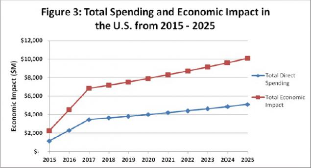
Total costs and economic benefits
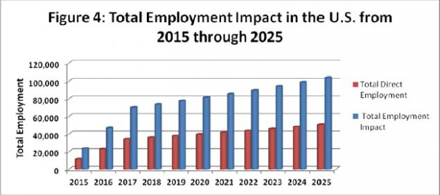
Job growth
It is very important to achieve such growth to solve the issues of state regulation of insurance and the use of airspace and flight safety.
But in addition to state regulation of insurance and require the creation of a number of technologies. What technologies are needed?
The Ministry of Defense and the Federal Aviation Administration called the following areas of research:
- The interaction and modularity - the development of an interface between modules (sensors, controllers and so on.) To reduce development time
- Communication systems - increasing range, bandwidth, and noise immunity
- Cybersecurity - increasing security threats BPLS from unauthorized access and disclosure of information
- Continuous improvement - improving characteristics such as size, weight, power, cooling, reliability, manageability, survivability, and others.
- Autonomy and cognitive behavior - reducing the cost of manual control man
- Armed - purely military applications
- Dropping sensors - the collection of information and performing other tasks on the surface
- Meteorology - collection of information for accurate weather forecasting
- High Performance Computing - increase in the number of sensors and the volume of information collected demanding higher computational efficiency
- Avoiding collisions - technologies for avoiding collisions, both in the air and on the ground
- Remote Monitoring and Control - change jobs during the flight, the UAV control groups
- The range and duration of flight - it is clear what I mean
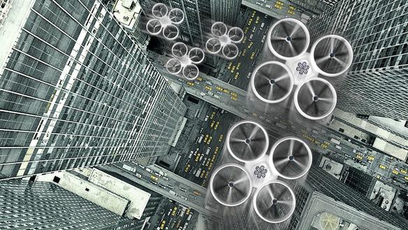
- Flying in formation - precise positioning of the UAV relative to each other in a system
- vertical flight - movement in the vertical direction for research at high altitudes
- Dock - on the ground and in the air with Georgia and other UAVs and so on.
- Manage unforeseen situations - minimizing the consequences of accidents UAVs and other situations
Here are some examples of the results obtained.
I am also interested in the topic to improve the range and duration of flight for multicopter as one of the top priorities.
Two solutions to improve the range and duration of flight h4>
Stand up for discussion are two solutions to improve the range and duration of flight multicopter.
Ask knowledgeable habravchan to participate and suggest answers to your questions.
copter wing + h5>
Multicopter combine with wings and get a new kind of VTOL. No ailerons and other moving parts (other than propellers).
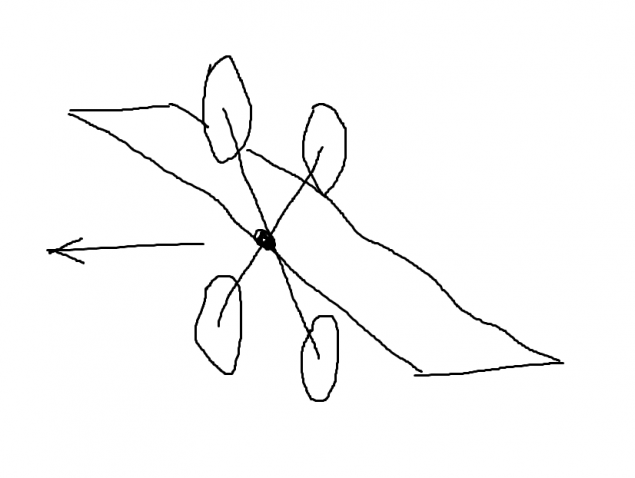
This solution is clear, but so far I have not found evidence that it has been successfully implemented in this form.
Questions for discussion:
How Come? What are the disadvantages of this solution have?
Here are the most successful examples of similar solutions:
And this windmill
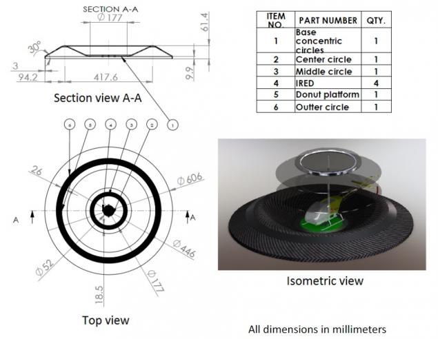
Ground Infrastructure h5>
More broad topic. As they say, is in the air. Meaning-making in the network of filling stations. Ideally - automatic.
Here the situation is better. There are specific designs. Take it and do.
Here are examples of works on the subject:
- Automatic Battery Replacement System for UAVs: Analysis and Design. Koji AO Suzuki Paulo Kemper F. James R. Morrison. Received: February 15, 2011 / Accepted: April 3, 2011
- UAV Consumable Replenishment: Design Concepts for Automated Service Stations. Paulo Kemper F.1 ∙ Koji A.O. Suzuki2 ∙ James R. Morrison3 *
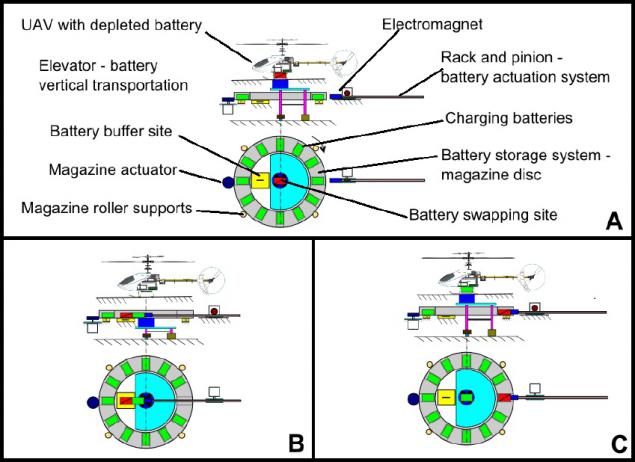
But there is a problem with the organization of a network of such stations with sufficiently dense coverage of the territory.
Questions for discussion:
What prevents to organize such a network, for example, in one of the districts of Moscow region by volunteers?
What are the technical problem to be solved?
Maybe someone else has already tried an autonomous non-stop flight to transport something to a friend or neighbor?
What should be the distance, height, trajectory between network nodes in accordance with the technical capabilities and standards of regulators?
Whether implemented automatic landing for topping up or changing the battery?
First we need to understand how far can a reliable autonomous flight from all points of view (technical, regulatory, legislative).
Then put on the map coordinates volunteers and understand the coverage area and the distance between them.
If the bands overlap, we can move on. Establish a procedure for refilling. And so on.
It is clear that the task is difficult, but I wonder the same to such a network has earned and began to carry loads.
I invite to discussion.
The discussion plan to formulate criteria (quantitative and qualitative) described the feasibility of ideas. Ideally I would like to receive the TK. B>
Not far off ... h4>
Let's dream a little and compare this project with the ARPANET. And after 30 years, so, imagine that this network (the name is already there - MatterNet) entangle all continents, and even across oceans will be transferred chain drifting gas platforms.
No borders and customs, almost nonexistent. Parcels with ebay and aliexpress from China go their way on multicopter.
In the comments to this post had enough ideas to implement. As they say it is small.
habrahabr.ru/post/181139/
Source: habrahabr.ru/post/209104/


Tags
See also
How will the delivery by drones from Amazon?
Cellar with their hands: sequential manual on the construction
Tiny drones for crop dusting
Students fashioned glider for the Martian atmosphere
Begin to fly